Table of Contents
Earthquakes
This article deals with ‘Earthquakes .’ This is part of our series on ‘Geography’ which is important pillar of GS-1 syllabus . For more articles , you can click here
Introduction
Sudden release of energy in Earth’s crust, which leads to series of motions due to waves created by the released energy is called Earthquake. Hence , it is nothing but release of energy.
Terminology
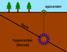
| Hypocentre/ Focus | Point inside surface where earthquake is generated by first rock displacement & fault is created. |
| Epicentre | Point on earths surface which is directly above hypocentre. Most destruction occurs here. |
Earthquakes occur in three forms of clusters
| Foreshocks | Occur before a larger one at same location. |
| Mainshocks | Are of highest magnitude & occur within an hour of foreshock. |
| Aftershocks | Are smaller quakes that occur at same general geographic location for days & even years after the larger main shock |
Types of Earthquake
1 . Types based on causes
a. Tectonic Earthquake
- Most common type are the tectonic earthquakes.
- These are generated due to sliding of rocks along a fault plane.
b. Volcanic Earthquake
- Due to volcanic eruption.
- But confined to areas having active volcanoes .
c. Collapse Earthquakes
- In the areas of intense mining activity, sometimes the roofs of underground mines collapse causing minor tremors.
d. Explosion Earthquake
- Ground shaking may also occur due to the explosion of chemical or nuclear devices.
e. Human Induced Earthquake
- Earthquakes that occur due to human activities
- Reservoir induced seismicity
- Mining related seismicity
- Groundwater extraction related earthquake
Types on basis of depth
a. Shallow focus
- Hypocentre is upto 70 km
- Not felt away from epicentre
- Cause maximum destruction in the region near epicentre (energy released is close to surface)
b. Medium focus
- Hypocentre is from 70 to 300 km
- Distance of impact and destruction potential between deep focus and shallow focus.
c. Deep Focus
- Hypocentre is below 300 km
- Felt upto large distance from epicentre
- Cause low destruction
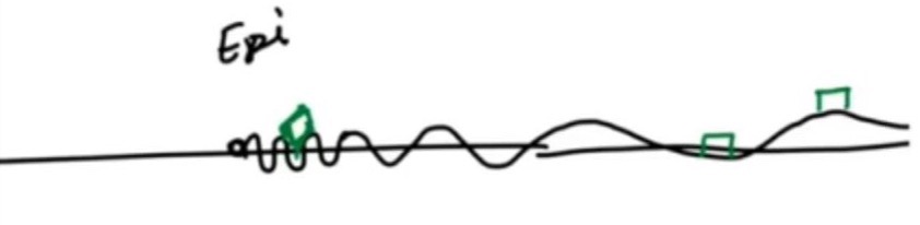
Side Topic : Why maximum destruction is near the epicentre?
As one moves away from the epicentre, wavelength of surface wave will increase. Hence, building situated near the epicentre will fall on both crest and trough of wave causing building to collapse while building situated away from the epicentre will either fall entirely on crest or trough not doing much damage.
Effects of Earthquake
Earthquake is a natural hazard. The following are the immediate hazardous effects of earthquake:
- Ground Shaking
- Land and mud slides.
- Soil liquefaction.
- Ground lurching .
- Avalanches.
- Ground displacement
- Floods from dam and levee failures .
- Fires.
- Structural collapse.
- Falling objects
- Tsunami.
- Change in course of river
- Human and property loss
- Cracks in building
Earthquake Belts in World
Three major earthquake belts in this world :-
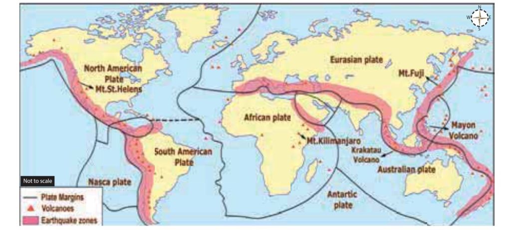
a. Circum-Pacific Belt
- Along a patch surrounding the Pacific ocean
- Region of great seismic activity eg Japan, Philippines, Chile etc lies here
- Coincides with Pacific Ring of Fire.
b. Alpine Himalayan Belt
- Runs through mountainous region that flank Mediterranean Sea extend through Iran & Himalayan mountains
- Frequent & destructive earthquakes occur here.
c. Other areas
- Northern Africa
- Rift Valley areas of the Red Sea and the Dead Sea.
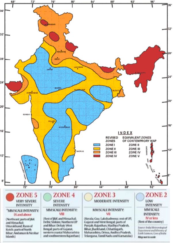
Earthquakes In India
- India has high frequency of great earthquakes (greater than 8.0) .
Reason
- Tectonic setting of India .
- Indian plate is moving at a speed of one cm/ year towards the north & north-eastern direction and this movement of plates is being constantly obstructed by the Eurasian plate from the north. As a result of this, both the plates are said to be locked with each other resulting in accumulation of energy . Excessive accumulation of energy results in building up of stress, which ultimately leads to the breaking up of the lock & sudden release of energy causing earthquake
Region has remained seismically quiet for more than 600-700 years => enormous buildup of strain => Earthquake of magnitude 8.5 or more can hit region in near future
Some Great Earthquakes occurred in India.
| 1819:Gujarat | 8.3 | |
| 1897:Assam | 8.7 | Extensive liquefaction in alleviated plains of Brahmaputra. |
| 1934:Bihar-Nepal | 8.4 | Extensive liquefaction —-> buildings tilted & slumped bodily into ground. |
| 1967:Koyna | 6.5 | – 1962 —-> Koyna Dam built —> earlier area was aseismic but after this seismic activity increased—-> dam induced earthquake – Revision of Indian Seismic was done and in Zone map, Koyana was moved from Zone I to zone IV & Bombay to Zone III. |
Question : What are the reasons for occurrence of earthquakes in geologically inactive regions like Peninsular India ?
- It is possible that collision of Indian and Eurasian plate has generated stresses not only at boundaries but also inside plate. As a result zones of weakness have formed on the plate. There is possible breaking up of Indian plate, which is most evident along river Bhima near Latur and Osmanabad, regions experiencing disturbances in the past.
- Peninsular India is home to some grand dams and reservoirs which have resulted in reservoir induced earthquakes (eg. Koyna Dam).
Measuring the Earthquake
- The earthquake events are
scaled either according to the magnitude or intensity of the
shock.
- The magnitude scale is known as the Richter scale. The magnitude relates to the energy released during the quake. The magnitude is expressed in absolute numbers, 0-10.
- The intensity scale is named after Mercalli, an Italian seismologist. The intensity scale takes into account the visible damage caused by the event. The range of intensity scale is from 1-12.
1 . Richter Scale
- Concept of Earthquake magnitude was developed by Richter who invented Richter scale .
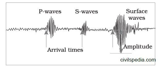
- It is Base 10 logarithmic scale obtained by calculating logarithm of shaking amplitude of largest displacement from zero Anderson Torsion seismometer at 100 kms from epicenter.
- Increase in 1 means 10 times more shaking amplitude.
- Earthquakes with magnitude more than 6 are destructive
2. Mercalli Scale
- Intensity scale is named after Mercalli, an Italian seismologist.
- Intensity scale takes into account the visible damage caused by the event.
- The range of intensity scale is from 1-12.
Side Topic: Shindo scale
- Known as Japanese Meteorological Agency(JMA) seismic intensity scale.
- Used in Japan & Taiwan.
- JMA scale tells us about degree of shaking at a point on earths surface .
- Ranges between Shindo 0(no shaking) to Shindo 7(most devastating).
- Same earthquake has different Shindo number at different locations.
EARTHQUAKE EARLY WARNING SYSTEM
- Earthquake Early warning system will issue warnings 1-40 seconds before earthquakes
- Based on detection of waves generated during an earthquake.
- P wave is harmless but travels faster than the Surface and S waves which cause maximum destruction
- This system works on detection of P wave for advance warning.
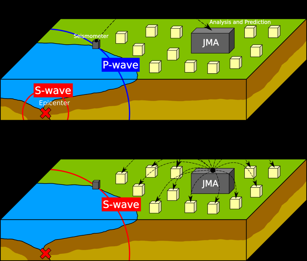
India has already installed it in Dehradun .