Table of Contents
Fluvial Landforms
This article deals with ‘Fluvial Landforms.’ This is part of our series on ‘Geography’ which is important pillar of GS-1 syllabus . For more articles , you can click here
Introduction
- When rain falls , part of it sinks into ground , some of it is evaporated back into the atmosphere & rest runs off as rivulets , streams and tributaries of rivers . This running water is potent agent of erosion .
- The river performs three types of work. They are erosion, transportation and deposition.
Materials transported/carried by river
When a river flows , it carries eroded material in four forms
- Solution – Material dissolved in water.
- Suspension – Sand, Silt & mud carried in suspended form.
- Saltation: Some of the fragments of the rocks move along the bed of a stream by bouncing continuously.
- Traction Load – This includes coarser materials such as pebbles , stones & boulders which are rolled along river bed .
Rivers carry great amount of material => Eg : Mississippi river removes 2 million tons to Gulf of Mexico daily .
River Erosion
In rivers, erosion comprise of following processes :-
- Corrasion / Abrasion : Mechanical grinding by
river’s traction load against banks & beds of river .
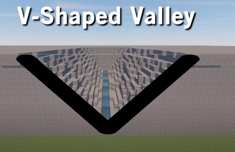
- Lateral Corrasion : sideways erosion which widens V-Shaped valley.
- Vertical Corrasion : downward action which deepens the river channel.
- Corrosion or Solution : chemical action of water on soluble or partly soluble rocks. Eg Calcium Carbonate in limestone is dissolved & removed in solution .
- Attrition : This is wear and tear of transported material themselves when they collide against one another.
- Hydraulic Action : This refers to mechanical action of water. Eg when water splashes against river banks , surges into cracks & disintegrate the rocks .
River deposition
- When the velocity of the stream decreases, the stream deposits sand, silt and other fragments
- When a river moves in a gentle slope, its speed reduces and river begins to deposit its load.
- The river starts depositing larger materials first and smaller and finer materials are carried further down to the mouth of the river.
Course of a River
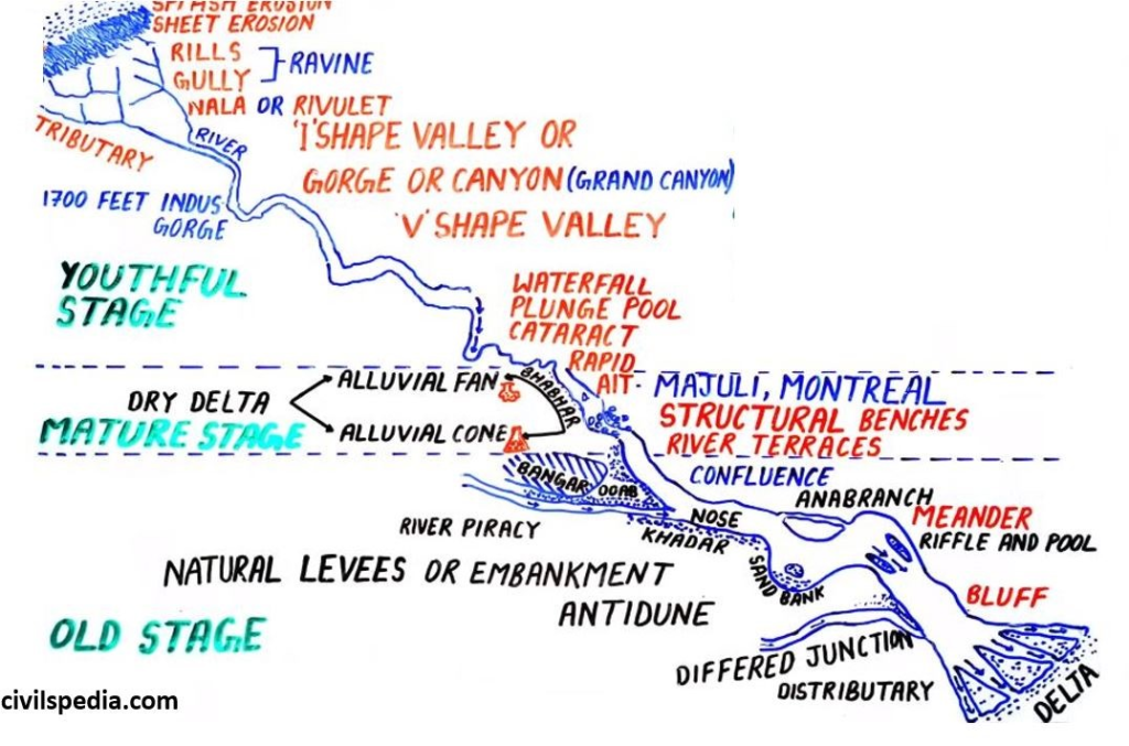
Upper or Mountain Course /Youthful Stage
In this stage
- Predominant Work = Erosion
- Predominant action = vertical corrasion.
Landforms formed in this stage
1. Valleys
1.1 V-Shaped Valley
- In upper course, vertical corrasion is at work . Downward cutting takes place so rapidly that lateral corrasion can’t keep pace. After some time, the loosened material slowly creeps downward and takes shape of V.
- The valley thus developed is deep , narrow & distinctively V-Shaped.
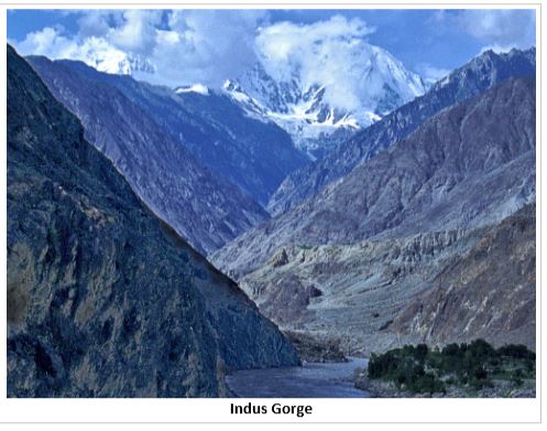
1.2 Gorges / I-shaped Valley
- In some cases, rocks are very resistant and hence afterward loosening don’t take place (because of resistant rock). The valley formed is so narrow & sides are so steep that gorges are formed .
- Eg : Indus Gorge in Kashmir .
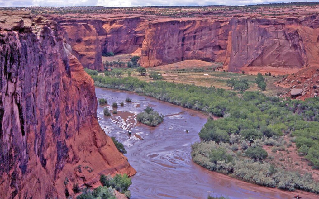
1. 3 Canyons
- Canyons are extended form of gorges.
- In arid regions, where there is little to widen the valley sides and river cuts deep into the valley floors , precipitous valleys called Canyons are formed.
- Eg Grand Canyon of Colorado river in Arizona state of USA .
2. Falls
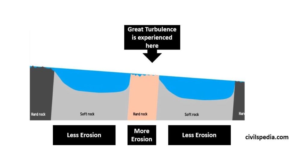
2.1 Rapids
- These can form in any part of river course but are more numerous in mountain course.
- They are formed when there are different layers of hard rock and soft rocks . Due to unequal resistance of hard & soft rocks , there is unequal erosion of both set of rocks . The hard rocks will make river to jump and fall down
2.2 Cataract
- Falls similar to rapids but of greater dimensions are referred to as Cataracts.
- There are 5 along the Nile that interrupt the smooth navigation.
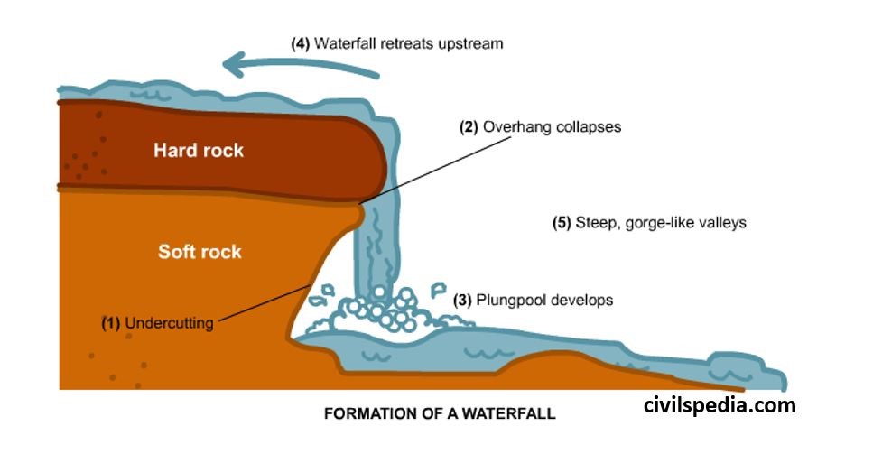
2.3 Waterfalls
- When rivers plunge down in a sudden fall of some height , they are known as waterfalls. Their force usually wears out a plunge pool beneath .
- They can be formed in various
ways
- When a bar of resistant rock lies transversely across a river valley . Eg Niagara Falls in US
- At fault line across river. Eg Victoria falls on River Zambezi
- When river plunges down the edge of a plateau like River Congo .
3. Entrenched /Incised Meanders
- These are formed when downcutting process is slow & river cause lateral erosion leading to asymmetric valley formation .
- Note : These are different from meanders which occur due to both erosion and deposition. In this, only erosion takes place.
Middle or Valley Course /Mature Stage
In Middle Course,
- In Middle Course, Erosion , Transportation and deposition is done by the river .
- But amount of erosion is very lower than Youthful stage and in that too, Lateral Corrasion tends to replace vertical corrasion.
- The volume of the water increases with the confluence of many tributaries & this increases the river’s load.
- Predominant work of the river = predominantly transportation with some deposition (main deposition happen in Oldage Stage).
Landforms formed in Middle Stage
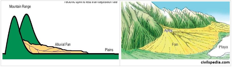
1 . Alluvial Fans
- Alluvial fans are formed when streams flowing from higher levels break into foot slope plains of low gradient. Normally very coarse load is carried by streams flowing over mountain slopes. This load becomes too heavy for the streams to be carried over gentler gradients and gets dumped and spread as a broad low to high cone shaped deposit called alluvial fan.
- Examples : Alluvial fans are found in Kosi river when it enters Bihar just after exiting Himalayas
2. Alluvial Cone
- As the velocity of river decreases, its transportation capacity also decreases. Due to this decline deposition starts in Foot Hills. This deposition forms Alluvial Cones.
- It is same as alluvial fan but slope is more (between 10 to 50 degree)
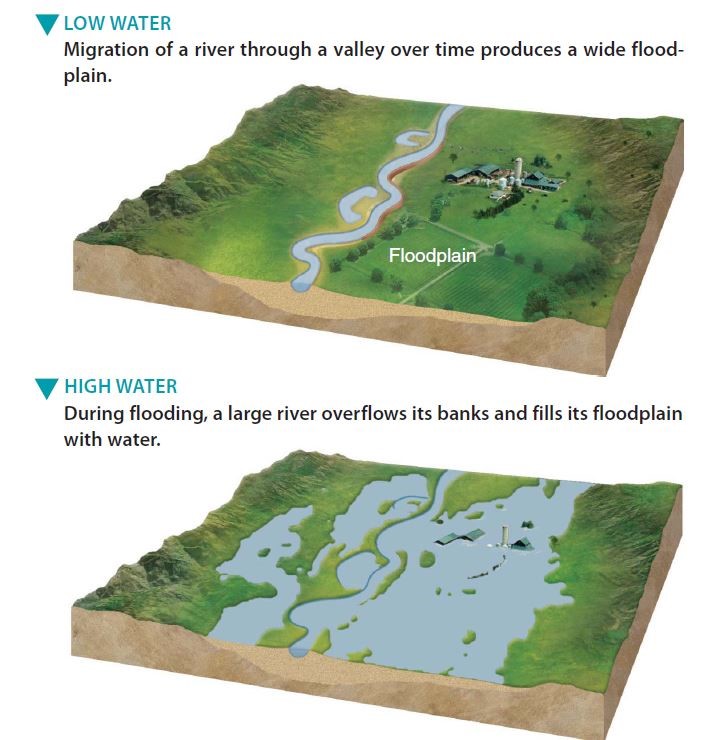
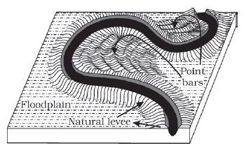
3. Flood Plains
- Rivers in their course carry large quantities of sediments . During annual or sporadic floods, these materials are spread over the low lying adjacent areas.
- A layer of sediment is thus deposited during each flood , gradually building up a fertile flood plain.
4. Levees
- With the continuous deposition of soil on the banks by the river, the level of banks rises and they look like natural dams known as levees .
- During flooding as the water spills over the bank, the velocity of the water comes down and large sized and high specific gravity materials get dumped in the immediate vicinity of the bank as ridges. They are high nearer the banks and slope gently away from the river
Lower or Plain Course /Old Age stage
In Lower/Oldage Course,
- River moving downstream across a broad and level plain is heavy with debris brought down from the upper course . Hence, work of the river is mainly deposition, building up its bed & forming extensive flood plains.
- Vertical corrasion has almost ceased though some lateral corrasion still goes on to erode its bank (like in Meanders).
Landforms formed in Later Stage
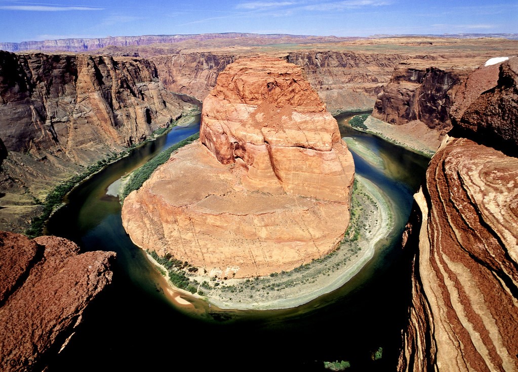
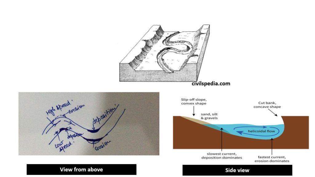
1 . Meanders
- A meander is a winding curve or bend in a river.
- Meanders are the result of both erosional and depositional processes.(explained in diagram below)
- The irregularities of the ground , force the river to swing in loops. Once the channel begins to flow in sinusoidal path , the amplitude & concavity of loop increases rapidly due to dense erosion occurring at the outside and deposition occurring inside .
- Note : Meanders can be found in Middle as well as Later Stage
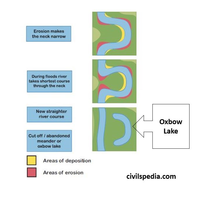
2. Ox-bow Lakes
- An oxbow lake is U-shaped body of water that forms when a wide meander from the main stream of river is cut off creating free standing body of water.
- It has different nomenclature at different places – Billabong in Australia, Rasacas in Texas etc
- Both meanders and ox bow lakes are formed both in middle and lower course. Ox Bow is more commonly found in lower course .
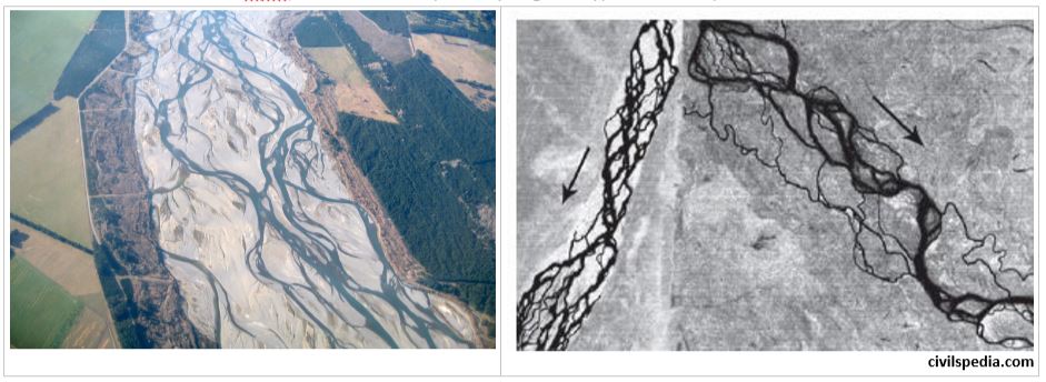
3. Braided Streams
- A braided stream is one which does not flow in a single definite channel but rather a network of everchanging, branching and reuniting channels.
- Thread-like streams of water rejoin and subdivide repeatedly to give a typical braided pattern
4. Delta
- When a river reaches the sea , the fine material it has not yet dropped are deposited at its mouth , forming a fan shaped alluvial area known as Delta .
- This alluvial tract is , infact , a seaward extension of the flood plain.
- Delta extend sideways and seaward at an amazing rate . The River Po extends its delta by over 40 feet a year
- (GK) Ganges Brahmaputra delta is the largest delta in the world.
Deltas differ in their size , shape , growth & importance. A number of factors such as the rate of sedimentation , the depth of the river & sea bed and character of tides , currents & waves greatly influence formation of Delta.
Different type of Deltas
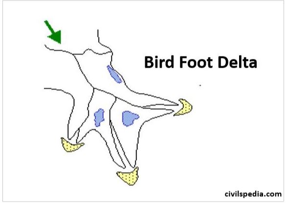
a. Bird’s foot Delta
- Deposited alluvial material divides the river into smaller distributaries. Several distributaries look like the foot of a bird.
- Example : Mississippi is example.
b. Arcuate shaped Delta
- Delta look fan shaped with numerous distributaries
- Examples are Amazon, Ganga & Mekong.

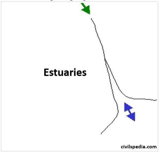
c. Estuarine Delta
- When river has their deltas submerged in coastal waters (mainly due to submerged coast like India’s western coast) or don’t have much deposition to form delta.
- Most of India’s west flowing rivers originating in Western Ghats.
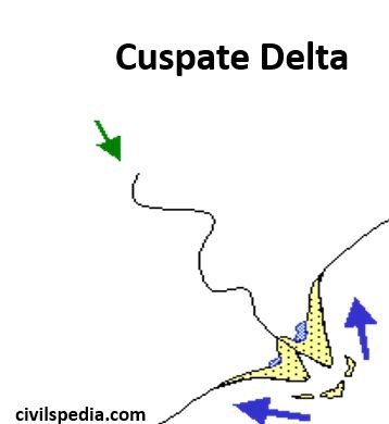
d. Cuspate Delta
- Have tooth like projection at their mouth.
- Example : Ebro of Spain.
Conditions favourable for formation of deltas are
- Active vertical & lateral erosion in upper course to provide sediments to be eventually deposited as Deltas.
- The sea adjoining the delta should be shallow or else the load will disappear in the deep waters.
- The coast should be sheltered, preferably tideless.
- There should be no large lakes in the river course to filter off the sediments.
- There should be no strong current running at right angle to the river mouth.
Importance of Deltas
a. Ecological importance
- Deltas absorb runoff from both floods (from rivers) and storms (from lakes or the ocean), filter water and thus reduces the impact of pollution flowing from upstream.
- Deltas are also important wetland habitats. They support extremely diverse and specialized flora and fauna and are areas of dense forests.
b. Economic importance
- Deltas are important places for trade and commerce, and major ports.
- Deltas due to rich accumulation of silt are fertile agricultural areas. World’s largest delta is the Ganges–Brahmaputra delta in India and Bangladesh, is densely populated supporting livelihood of millions. Fish, other seafood, and crops such as rice and tea are leading agricultural products of the delta.
- Deltas possess well sorted sand and gravel which is quarried.
- Due to their diversity they are centres of tourism and recreation.
Threat to Deltas
- Diversion of water for irrigation and creation of dams reduce sedimentation, which can cause delta to erode away.
- Climate change and rising sea level – rising sea level flood deltas bringing in saline water and threatening wetland ecosystem. For example nearly 31 square miles of Sundarbans have vanished entirely due to sea level rise.
- Use of water upstream can greatly increase salinity levels as less fresh water flows to meet salty ocean water.
While nearly all deltas have been impacted to some degree by humans, the Nile Delta and Colorado River Delta are some of the most extreme examples of ecological devastation