Table of Contents
Temperature and Heat Budget of Earth
This article deals with ‘Temperature and Heat Budget of Earth’ This is part of our series on ‘Geography’ which is important pillar of GS-1 syllabus . For more articles , you can click here
Air Temperature
- Air temperature of a particular place denotes the degree of hotness or coldness of air at a given place. It is generally measured in Celsius
Heating process of Atmosphere
There are different ways of heating & cooling of the atmosphere.
- Conduction :The air in contact with the land gets heated by conduction . Conduction is important in heating the lower layers of the atmosphere.
- Convection : The air in contact with the earth rises vertically on heating in the form of currents and further transmits the heat of the atmosphere. This process of vertical heating of the atmosphere is known as convection. The convective transfer of energy is confined only to the troposphere.
- Advection : The transfer of heat through horizontal movement of air is called advection. (In northern India, during summer season local winds called ‘loo’ is the outcome of advection process).
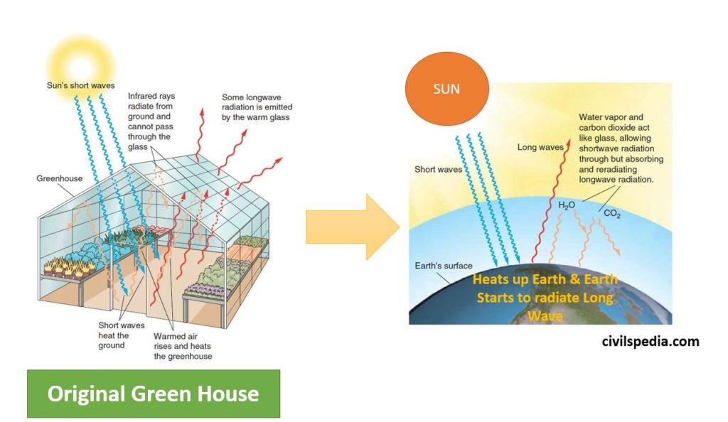
- Radiation (Green House effect) : The insolation received by the earth is in short wave form and it heats up surface. The earth after being heated itself becomes a radiating body and it radiates energy to the atmosphere in long wave form. The long wave radiation is absorbed by the atmospheric gases particularly by carbon dioxide & other Green House Gases. Thus, the atmosphere is indirectly heated by the earth’s radiation.
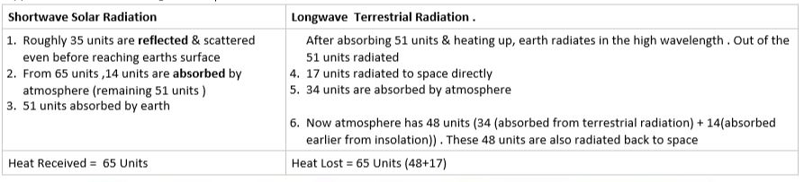
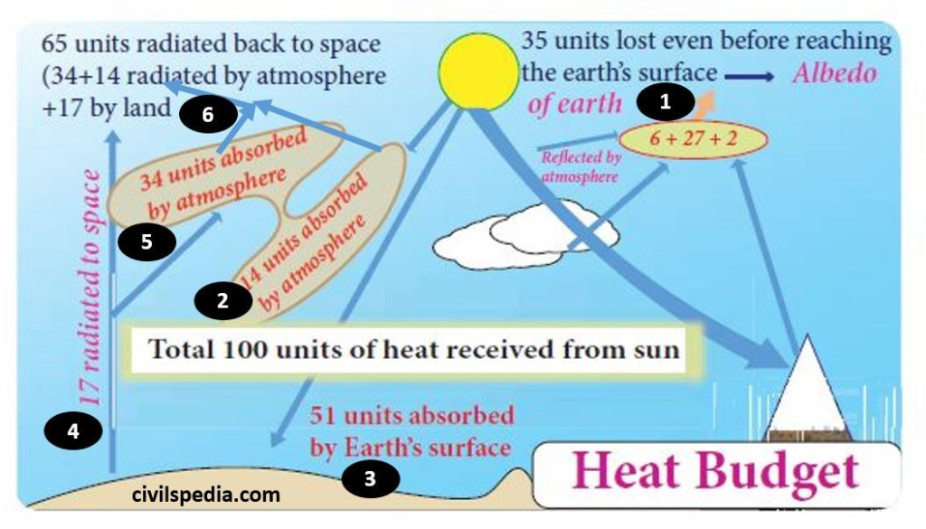
Heat Budget of Earth
The earth as a whole does not accumulate or loose heat. It maintains its temperature. This can happen only if the amount of heat received in the form of insolation equals the amount lost by the earth through terrestrial radiation. This is known as Heat Budget of Earth
This is done in following way
Suppose 100 units are coming to earth
Factors affecting Horizontal temperature distribution
1 . Latitude of the place
- Insolation received by any place depend upon latitude because when we move from equator towards pole, sun-rays become slanted . In slanted sun-rays, same energy is diffused over large area
- Conclusion : Temperature decreases from the equator to the poles.

2. Distribution of Land and Water
- Compared to land, the sea gets heated slowly and loses heat slowly. Land heats up and cools down quickly.
- So more land mass in northern hemisphere leads to higher average temperature than the southern hemisphere
3. Presence of warm & cold current
- Places located on the coast where the warm ocean currents flow record higher temperature than the places located on the coast where the cold currents flow.
4. Air mass circulation
- The passage of air masses also affects the temperature. The places, which come under the influence of warm air-masses experience higher temperature and the places that come under the influence of cold airmasses experience low temperature.
5. Cloudiness
- Cloudy sky obstructs the solar radiation from the sun to reach earth. Hence, clear sky increases the temperature of place.
- Due to this, Maximum insolation is received over the subtropical deserts, where the cloudiness is the least. Equator receives comparatively less insolation than the tropics because of clouds.
6. Nature of Surface
- Albedo ie ability of surface to reflect the sunrays also impact temperature of place.
- Fresh snow has albedo of upto 90% and more reflection from the snow surface leads to low temperature accumulation compared to bare land.
7. Local aspects
- Depend on position to position.
Factors affecting vertical temperature distribution
- The temperature decreases with increasing altitude from the surface of the earth.
- Reason : Atmosphere is indirectly heated by terrestrial radiation from below. Therefore, the places near the sea-level record higher temperature than the places situated at higher elevations.
- The vertical decrease in temperature of troposphere is called as ‘Normal Lapse Rate’ which is 6.5 C per 1000 meter of ascent.
Temperature Inversion
- Normally , within Troposphere, temperature decreases with increase in height . But if reverse happens, it is called Temperature Inversion .
- Since cold air is denser/heavier than warm air , in case of temperature inversion, air will not be able to move upward .

When Temperature Inversion can happen
- At Tropopause : Temperature starts to increase from here . As a result, air packets reach till Tropopause & then starts moving downward . There is no vertical air movement after that
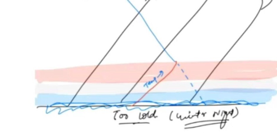
- A cool winter night with no clouds and stable air : Air above cold surface gets cold but layer above cold air is still warmer & hence it cant move upward . This phenomenon is prominent till 400 m above earth’s surface.
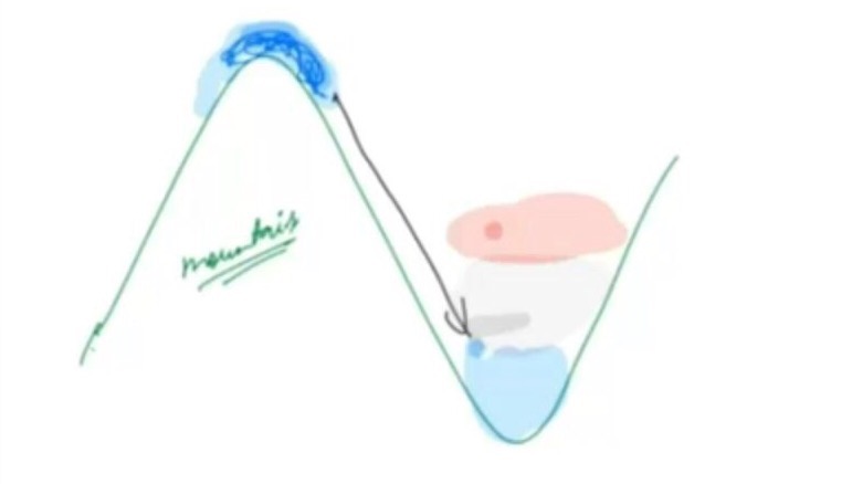
- Valley Inversion/Air Drainage : In winter, mountain top becomes cold quickly compared to valley . As a result, cold air comes down to occupy valley . This uplifts warm air of valley & situation is created when lower layer is cold & upper layer is warm
- Frontal inversion occurs when a cold air mass undercuts a warm air mass and lifts it
Implications of Temperature Inversion
1 . Formation of Fog
- As we have seen in currents , where ever warm & cold current meet , fog is created
- In same way , when warm air & cold air meets , fog is created . This lowers the visibility in region.
2. Atmospheric Stability
- Temperature Inversion prevents upward & downward movement of air.
- Hence, it discourages rainfall.
3. Impact on Agriculture
- Frost formed due to valley inversion damages crops in foothills, whereas trees and vegetation at top of hills and mountains are not damaged. The valley floors in the hills of Brazil are avoided for coffee cultivation because of frequent frosts.
- (Beneficial Case : Though generally fog (caused due to temperature inversion) is unfavourable for many agricultural crops such as grams, peas, mustard plants, wheat etc. but sometimes they are also favourable for some crops such as coffee plants in Yemen hills of Arabia where fog protect coffee plants from direct strong sun’s rays. )
4. Environmental problem
- In winters, concentration of pollutants raises to very high levels in cities as due to temperature inversion, air gets trapped . Eg : Delhi’s pollution levels are more in winters than summers.

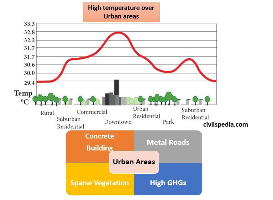
Urban Heat Island
An urban heat island is an urban area or metropolitan area that is significantly warmer than its surrounding rural area due to high concentration of high rise concrete buildings, metal roads, sparse vegetation cover and less exposure of soil. These factors cause urban regions to become warmer than their rural surroundings, forming an “island” of higher temperatures.