Table of Contents
Geographical Setting of India and it’s impact on History
This article deals with ‘Geographical Setting of India and it’s impact on History’ . This is part of our series on ‘Ancient History’, which is an important pillar of the GS-1 syllabus. For more articles, you can click here.
Introduction
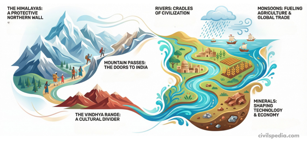
India’s history cannot be understood without first looking at its geography. Mountains, rivers, monsoon, passes, minerals and natural barriers have all shaped where people lived, how they farmed, traded and fought, and how cultures spread.
1. Himalayan Boundaries: A Natural Wall and a Shelter
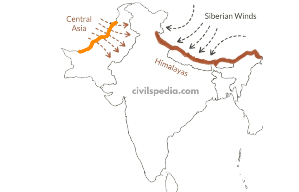
The Himalayas form India’s northern frontier.
- These mountains worked as a natural barrier against Central Asian tribes, reducing the frequency of invasions from the north.
- They also block icy Siberian winds, keeping northern India relatively warmer and making it a favourable place for human settlement and agriculture. Because of this, fertile plains such as those of the Ganga and Yamuna could sustain dense populations and continuous civilisation.
2. Mountain Passes: Gateways of Interaction
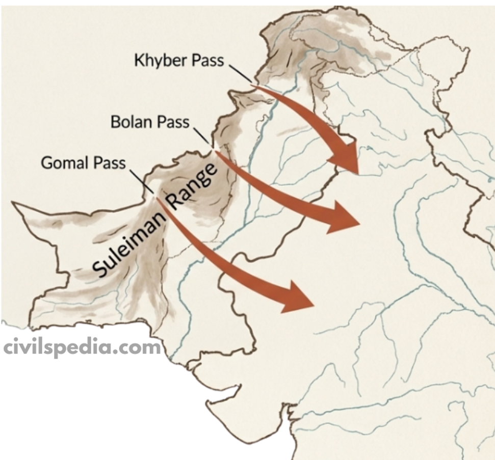
- Although the Himalayas formed a wall, certain gaps acted as doors.
- The Suleiman Range—an extension of the Himalayas—contains the famous Khyber, Bolan, and Gomal passes. Throughout history, invaders and migrants used these passes to enter India, bringing new ideas, goods and cultures. This is how Indo-Greek, Kushana, and later Central Asian influences reached the subcontinent.
3. Role of the Monsoon: Lifeline of Agriculture and Trade
- The monsoon dominates India’s climate. Seasonal rains enabled ancient farmers to cultivate surplus food, which in turn supported the rise of cities and complex societies. Without predictable monsoon rains, large settled populations would have been difficult to sustain.
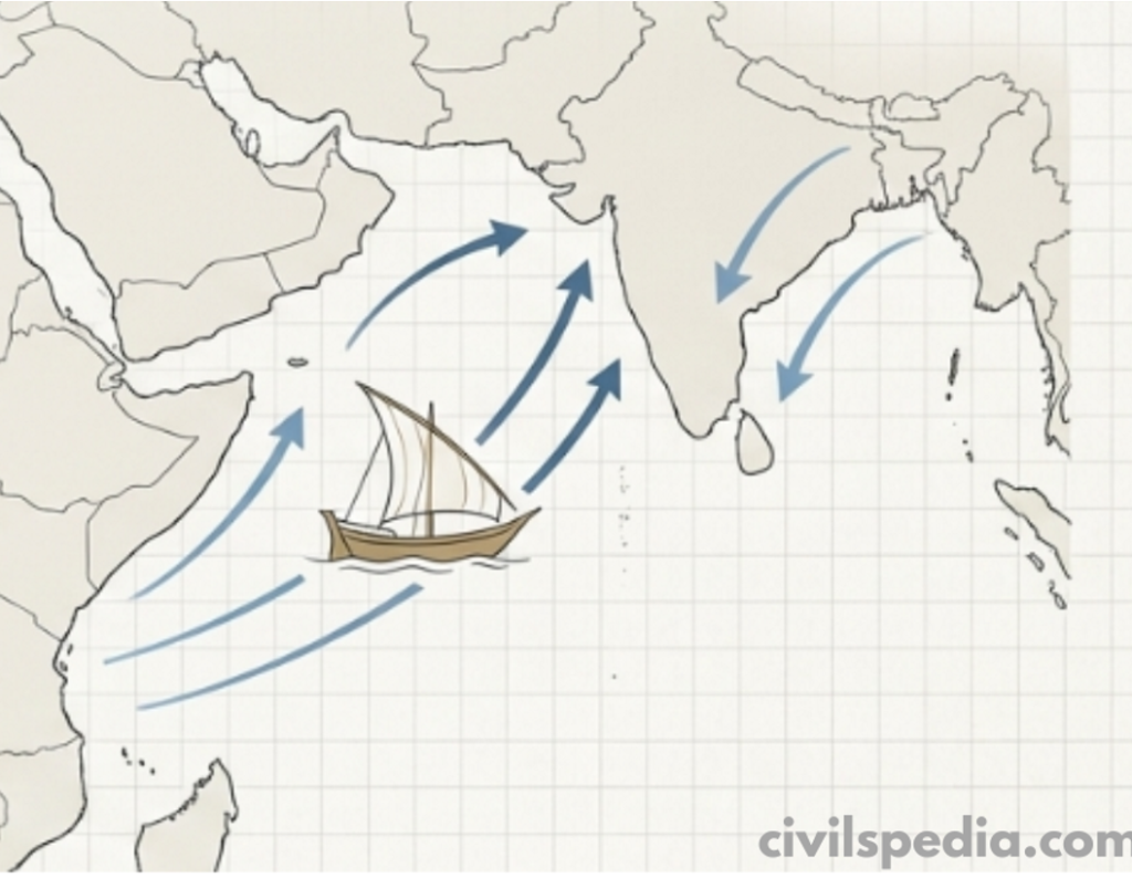
- Monsoon winds also shaped India’s external trade. Ancient texts like the Periplus of the Erythraean Sea mention that in 45 AD, the navigator Hippalus discovered the reversal of monsoon winds, enabling Roman traders to sail directly to Indian ports. Thus, the same winds that watered crops also carried ships and commerce.
4. Rivers: Cradles of Civilisation
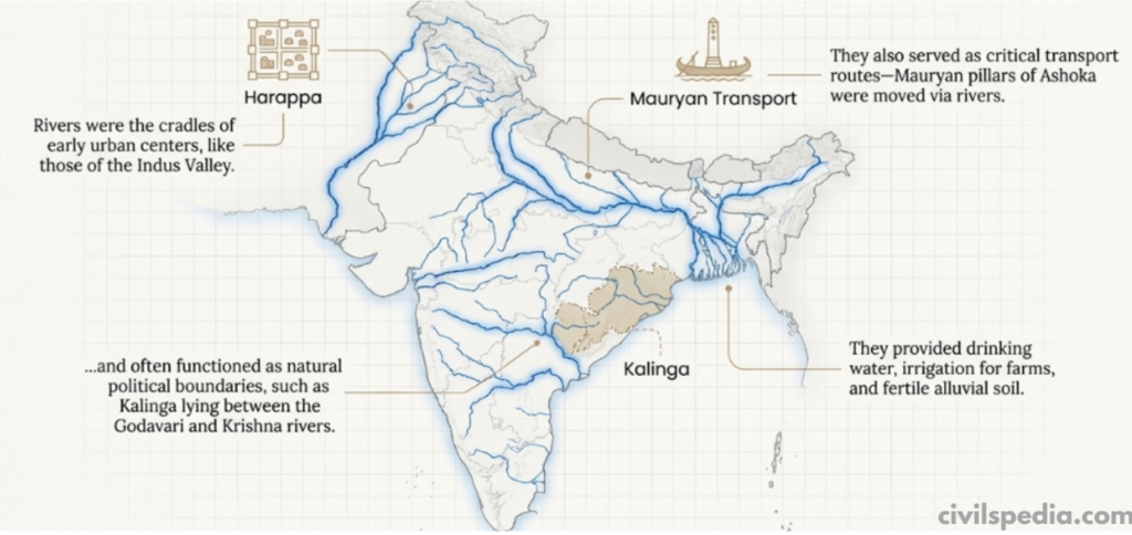
- Rivers are another major feature of India’s geography. They supplied drinking water, irrigation, fertile soil and transport routes. The earliest urban centres—like those of the Indus Valley—arose on riverbanks. Even in later times, Mauryan pillars of Ashoka were transported via rivers, showing how waterways eased movement.
- Rivers often served as political boundaries: for example, Kalinga lay between the Godavari and Krishna rivers.
The Indus in an “Arid” Region – Why Civilisation Flourished there?
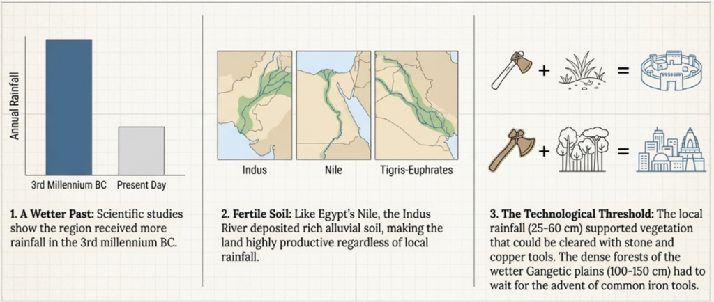
- Modern scientific studies show that during the 3rd millennium BC, the Indus region received more rainfall than today and had richer vegetation.
- Additionally, the Indus itself supplied irrigation water, so rainfall was not the only deciding factor.
- The main factor for the development of civilisation was agriculture. The Indus region was fertile. If we take the example of Egypt (Nile) and Mesopotamia (Euphrates), they lie in arid regions, but alluvial soil due to sediments brought by rivers became the reason that the greatest civilisations emerged in these regions.
- The Harappan civilisation grew mainly where annual rainfall was 25–60 cm, a zone that could be cleared with stone and copper tools. Further east, rainfall rose to 100–150 cm; such dense vegetation could only be cleared once iron tools became common, which explains why large settlements appeared later in the Gangetic plains.
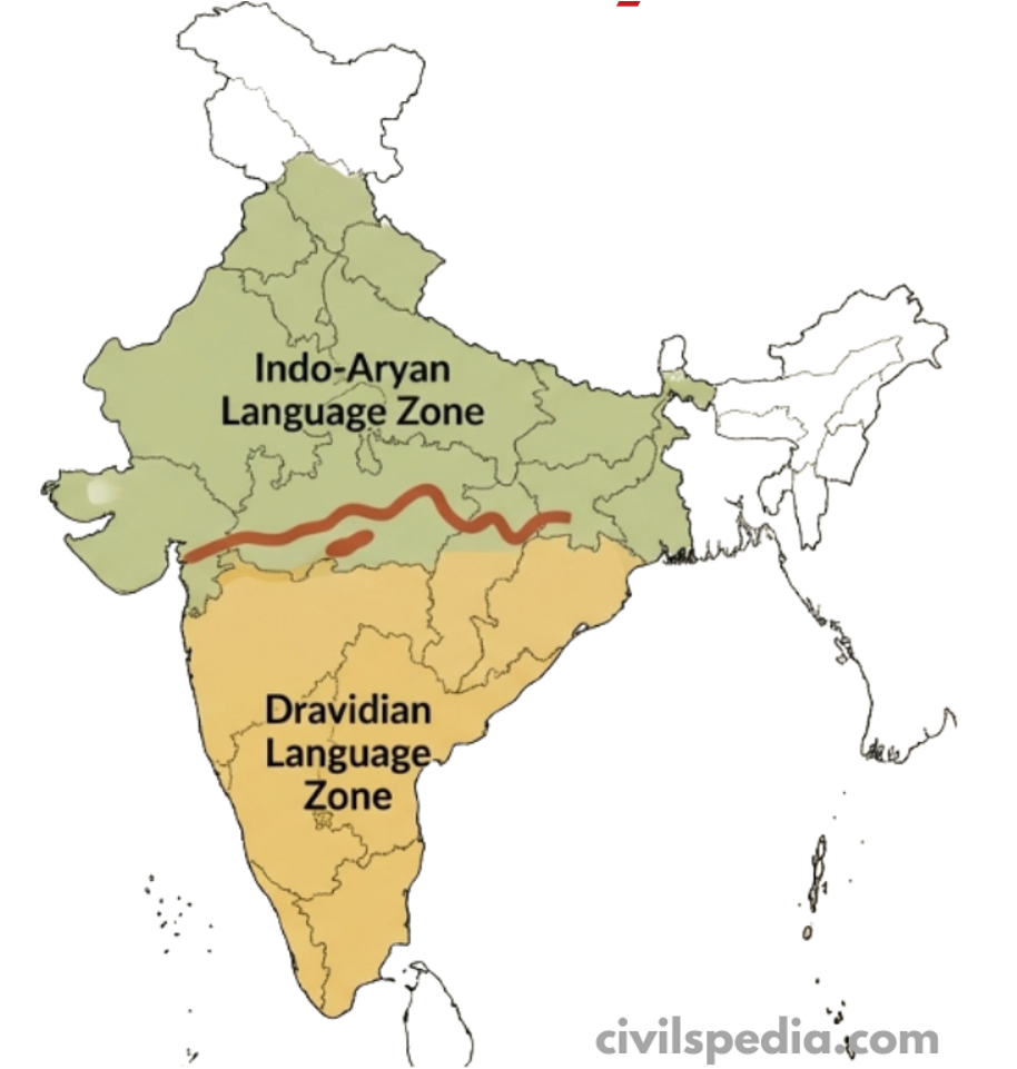
5. The Vindhyas: A Cultural Divider, Not a Complete Barrier
- The Vindhya range roughly separates North and South India. North of it, Indo-Aryan languages dominate; south of it, Dravidian languages prevail, and the architecture, temple styles and music also show regional differences.
- But Vindyas were not an insurmountable barrier as the Himalayas and many elements intermingled with each other, leading to a mix of northern and southern elements throughout history.
6. Minerals: Linking Regions and Shaping Technology
- Minerals occur in pockets, creating natural trade networks. For example, copper from the Khetri mines in Rajasthan reached the Indus Valley, indicating long-distance exchange even in prehistoric times.
- India, however, has very little tin, which is necessary to make bronze. This shortage meant that India’s Bronze Age was limited compared to Mesopotamia or Egypt, and even the Indus Valley produced fewer bronze artefacts.
- In contrast, Andhra had abundant lead deposits. The Satavahana dynasty, which ruled this region, minted large numbers of lead coins—an example of how local resources shaped political and economic practices.
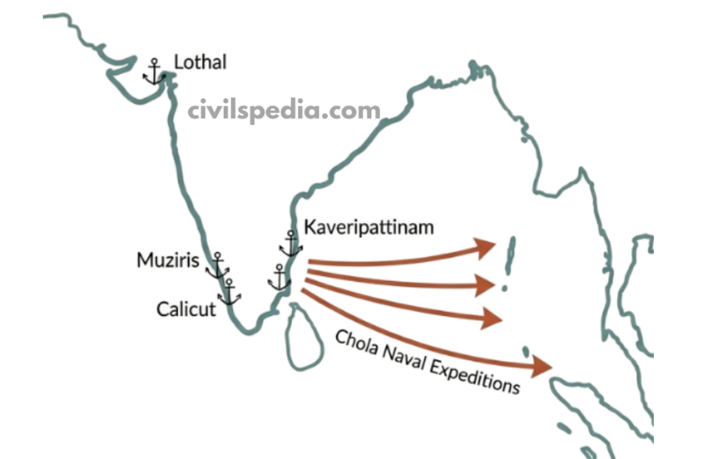
7. Coastal Geography & Maritime History
- India has a 7,500-km coastline with many natural harbours such as Lothal (Indus Valley), Muziris (Kerala), Kaveripattinam (Tamil Nadu), and later ports like Calicut. This geography enabled early maritime trade with the Persian Gulf, Egypt, Southeast Asia and later Rome and China.
- Coastal monsoon patterns created predictable “sailing seasons” and led to the rise of powerful coastal kingdoms such as the Cholas, who sent expeditions to Southeast Asia.
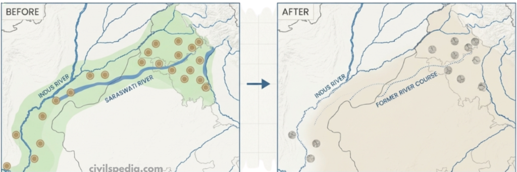
8. Seismic & River Course Changes
Rivers in India often changed their courses due to earthquakes and tectonic shifts. The Saraswati–Ghaggar–Hakra system, once a mighty river, gradually dried up, leading to the decline of many Harappan settlements along its banks. This shows how dynamic geography directly affected the stability and survival of ancient civilisations.