This article deals with ‘Defining Pollution – UPSC.’ This is part of our series on ‘Environment’, which is an important pillar of the GS-3 syllabus. For more articles on Science and technology, you can click here
What is Pollution?
Pollution is the undesirable change in biological, chemical and physical characteristics due to human and natural activities.
Pollutants are the agents which cause pollution.
Types of Pollutants
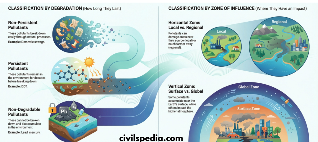
#1 On the Basis of Degradation
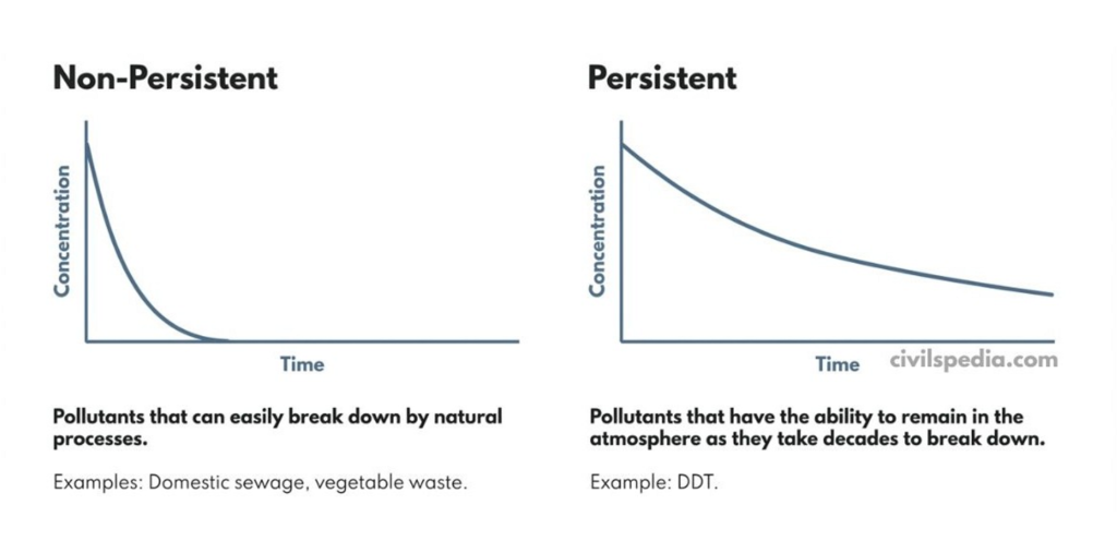
1. Non-Persistent Pollutants
Pollutants that can easily break down by natural processes.
For example, domestic sewage and vegetable waste.
2. Persistent Pollutants
Pollutants that have the ability to remain in the atmosphere as they takes decades to breakdown.
For Example, DDT
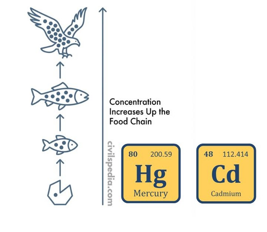
3. Non-Degradable Pollutants
These pollutants can’t be degraded by natural processes. Hence, they remain in the atmosphere forever and bioaccumulate if they are released into the atmosphere.
For Example, Toxic elements like lead, mercury, cadmium, chromium and nickel.
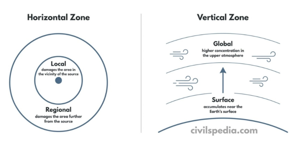
#2 On the basis of Zones of Influence
Pollutants can also be defined wrt their zones of influence
2.1 Horizontal Zone
It is defined wrt an area damaged by the pollutant
Local Pollutant: They damage area in the vicinity of the source
Regional Pollutant: They damage area further from the source
2.2 Vertical Zone
It is defined wrt the height up to which pollutants show their impact.
Surface Pollutant: These pollutants accumulate near the Earth’s surface.
Global Pollutants: These pollutants have a higher concentration in the higher atmosphere.
#3 Existence in Nature
3.1 Quantitative Pollutants
Substances which are already present in the environment, but are termed as pollutants when their concentration (quantity) increases in the environment.
E.g. : CO2 is present in the environment but when it’s concentration increases, it becomes pollutant.
3.2 Qualitative Pollutants
Substances that are present ordinarily present in the atmosphere and don’t cause any harm. But they become pollutants only when their concentration increases beyond a certain limit.
E.g., CO2 is present in the environment, but when its concentration increases, it becomes a pollutant.
Geographical Setting of India and it’s impact on History
This article deals with ‘Geographical Setting of India and it’s impact on History’ . This is part of our series on ‘Ancient History’, which is an important pillar of the GS-1 syllabus. For more articles, you canclick here.
Introduction
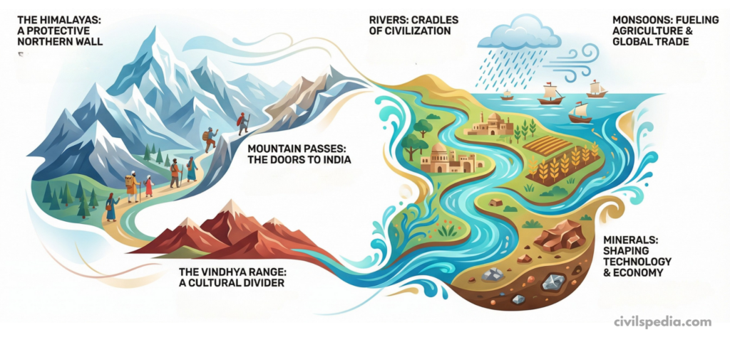
India’s history cannot be understood without first looking at its geography. Mountains, rivers, monsoon, passes, minerals and natural barriers have all shaped where people lived, how they farmed, traded and fought, and how cultures spread.
1. Himalayan Boundaries: A Natural Wall and a Shelter
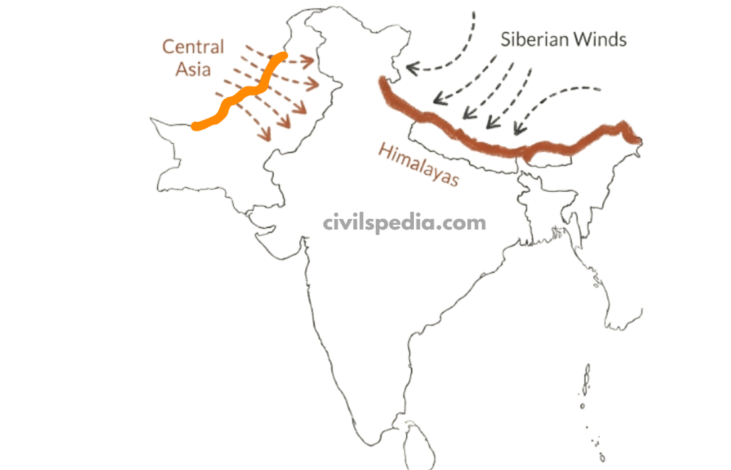
The Himalayas form India’s northern frontier.
These mountains worked as a natural barrier against Central Asian tribes, reducing the frequency of invasions from the north.
They also block icy Siberian winds, keeping northern India relatively warmer and making it a favourable place for human settlement and agriculture. Because of this, fertile plains such as those of the Ganga and Yamuna could sustain dense populations and continuous civilisation.
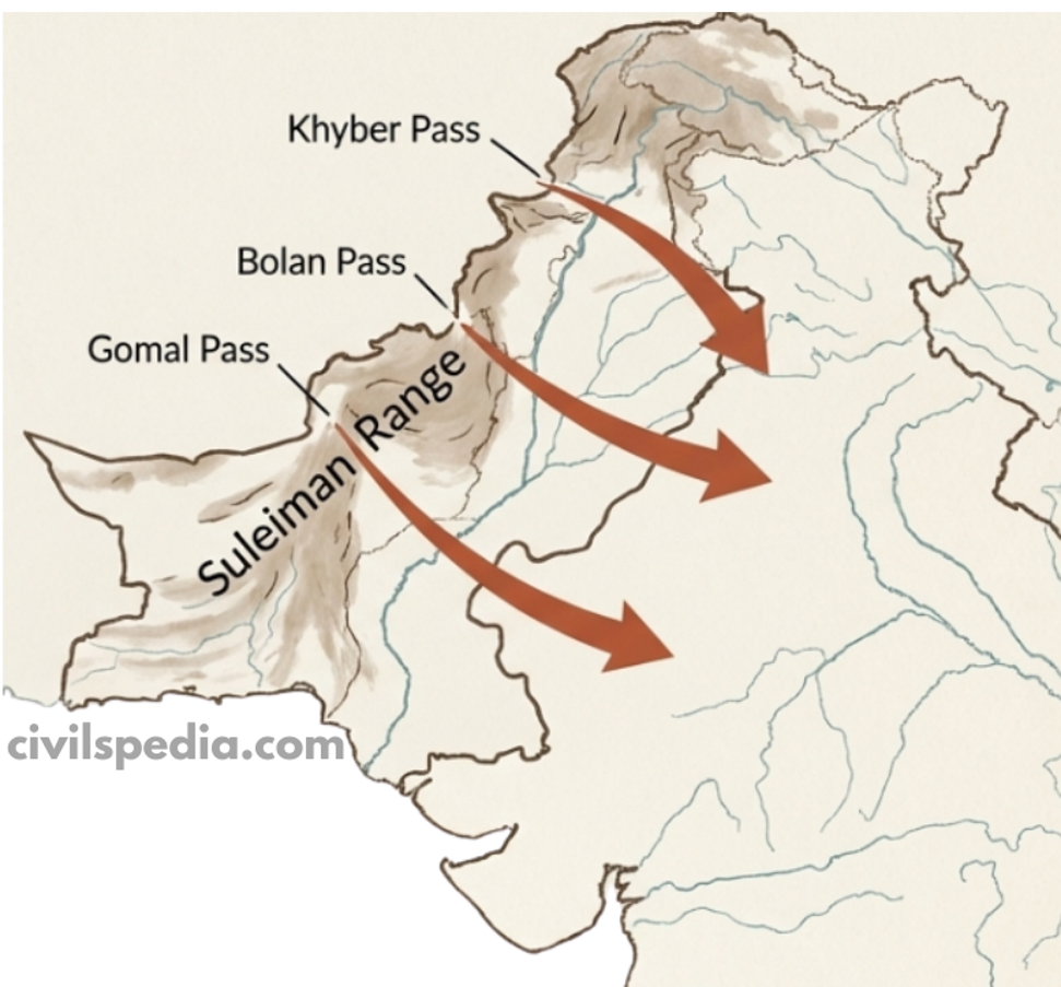
2. Mountain Passes: Gateways of Interaction
Although the Himalayas formed a wall, certain gaps acted as doors.
The Suleiman Range—an extension of the Himalayas—contains the famous Khyber, Bolan, and Gomal passes. Throughout history, invaders and migrants used these passes to enter India, bringing new ideas, goods and cultures. This is how Indo-Greek, Kushana, and later Central Asian influences reached the subcontinent.
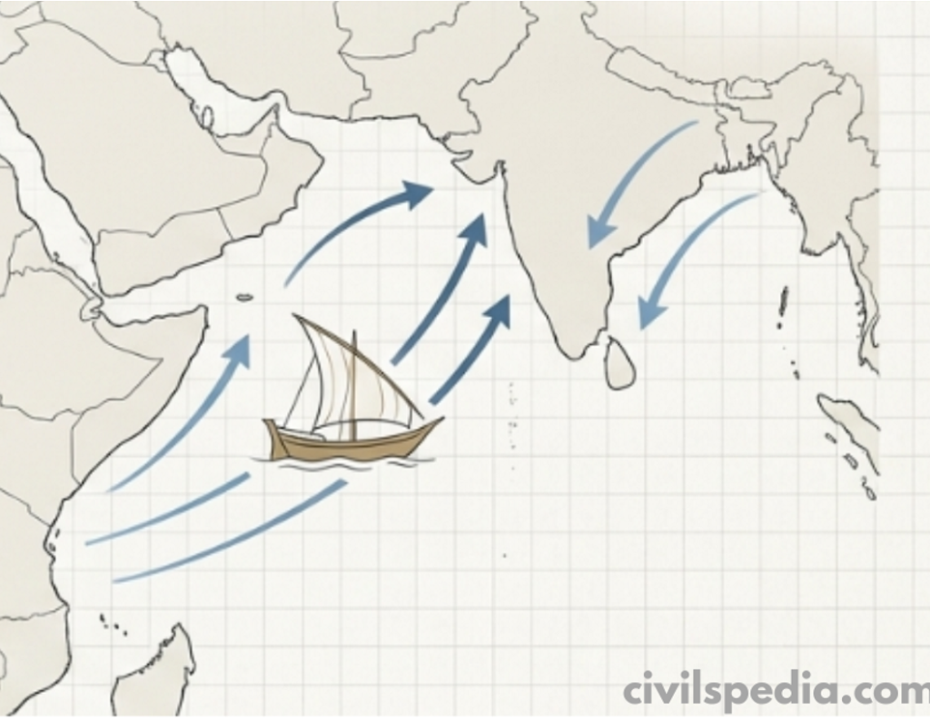
3. Role of the Monsoon: Lifeline of Agriculture and Trade
The monsoon dominates India’s climate. Seasonal rains enabled ancient farmers to cultivate surplus food, which in turn supported the rise of cities and complex societies. Without predictable monsoon rains, large settled populations would have been difficult to sustain.
Monsoon winds also shaped India’s external trade. Ancient texts like the Periplus of the Erythraean Seamention that in 45 AD, the navigator Hippalus discovered the reversal of monsoon winds, enabling Roman traders to sail directly to Indian ports. Thus, the same winds that watered crops also carried ships and commerce.
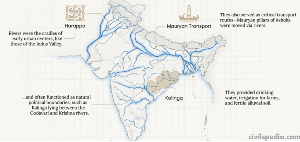
4. Rivers: Cradles of Civilisation
Rivers are another major feature of India’s geography. They supplied drinking water, irrigation, fertile soil and transport routes. The earliest urban centres—like those of the Indus Valley—arose on riverbanks. Even in later times, Mauryan pillars of Ashoka were transported via rivers, showing how waterways eased movement.
Rivers often served as political boundaries: for example, Kalinga lay between the Godavari and Krishna rivers.
The Indus in an “Arid” Region – Why Civilisation Flourished there?
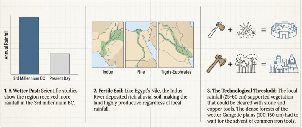
Modern scientific studies show that during the 3rd millennium BC, the Indus region received more rainfall than today and had richer vegetation.
Additionally, the Indus itself supplied irrigation water, so rainfall was not the only deciding factor.
The main factor for the development of civilisation was agriculture. The Indus region was fertile. If we take the example of Egypt (Nile) and Mesopotamia (Euphrates), they lie in arid regions, but alluvial soil due to sediments brought by rivers became the reason that the greatest civilisations emerged in these regions.
The Harappan civilisation grew mainly where annual rainfall was 25–60 cm, a zone that could be cleared with stone and copper tools. Further east, rainfall rose to 100–150 cm; such dense vegetation could only be cleared once iron tools became common, which explains why large settlements appeared later in the Gangetic plains.
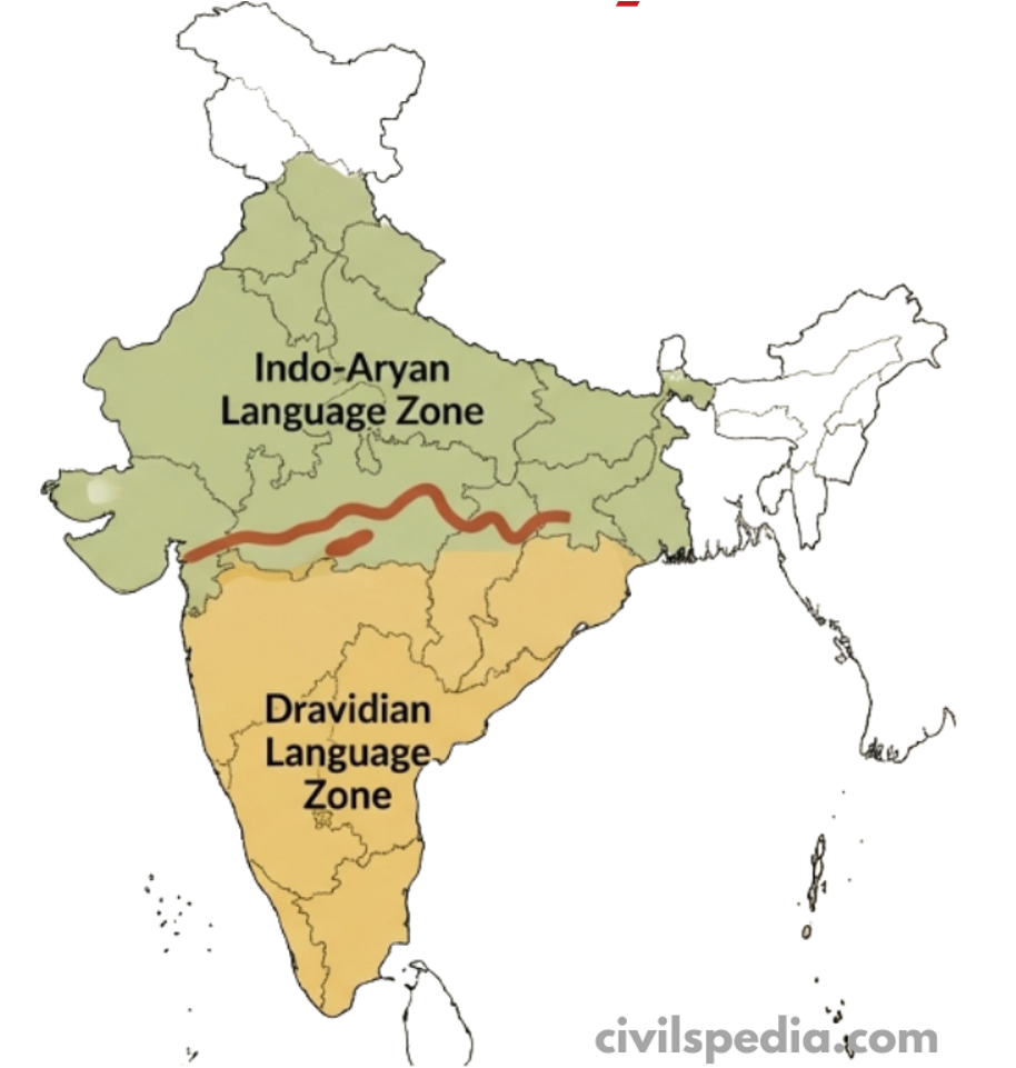
5. The Vindhyas: A Cultural Divider, Not a Complete Barrier
The Vindhya range roughly separates North and South India. North of it, Indo-Aryan languages dominate; south of it, Dravidian languages prevail, and the architecture, temple styles and music also show regional differences.
But Vindyas were not an insurmountable barrier as the Himalayas and many elements intermingled with each other, leading to a mix of northern and southern elements throughout history.
6. Minerals: Linking Regions and Shaping Technology
Minerals occur in pockets, creating natural trade networks. For example, copper from the Khetri mines in Rajasthan reached the Indus Valley, indicating long-distance exchange even in prehistoric times.
India, however, has very little tin, which is necessary to make bronze. This shortage meant that India’s Bronze Age was limited compared to Mesopotamia or Egypt, and even the Indus Valley produced fewer bronze artefacts.
In contrast, Andhra had abundant lead deposits. The Satavahana dynasty, which ruled this region, minted large numbers of lead coins—an example of how local resources shaped political and economic practices.
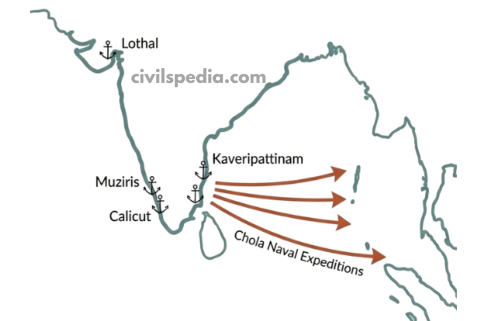
7. Coastal Geography & Maritime History
India has a 7,500-km coastline with many natural harbours such as Lothal (Indus Valley), Muziris (Kerala), Kaveripattinam (Tamil Nadu), and later ports like Calicut. This geography enabled early maritime trade with the Persian Gulf, Egypt, Southeast Asia and later Rome and China.
Coastal monsoon patterns created predictable “sailing seasons” and led to the rise of powerful coastal kingdoms such as the Cholas, who sent expeditions to Southeast Asia.
8. Seismic & River Course Changes
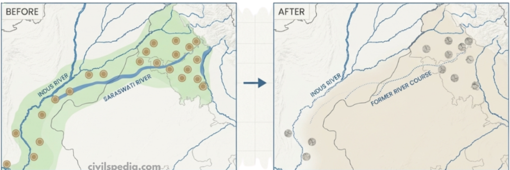
Rivers in India often changed their courses due to earthquakes and tectonic shifts. The Saraswati–Ghaggar–Hakra system, once a mighty river, gradually dried up, leading to the decline of many Harappan settlements along its banks. This shows how dynamic geography directly affected the stability and survival of ancient civilisations.
Last Updated: September 2025 (India-Mauritius Relations)
Table of Contents
India-Mauritius Relations
This article deals with ‘India-Mauritius Relations.’ This is part of our series on ‘International Relations’, which is an important pillar of the GS-2 syllabus. For more articles, you can click here.
Introduction
India and Mauritius share a relationship that is often described as civilisational rather than transactional. Bound together by a common history of migration, culture, language and values, Mauritius hosts one of the largest Indian-origin communities in the world. These deep people-to-people ties have translated into close political, economic, and security cooperation, making India Mauritius’ principal development partner and security provider in the Indian Ocean region. The island nation, in turn, serves as a bridge for India’s outreach to Africa and a key node in its maritime strategy.
Historical Context
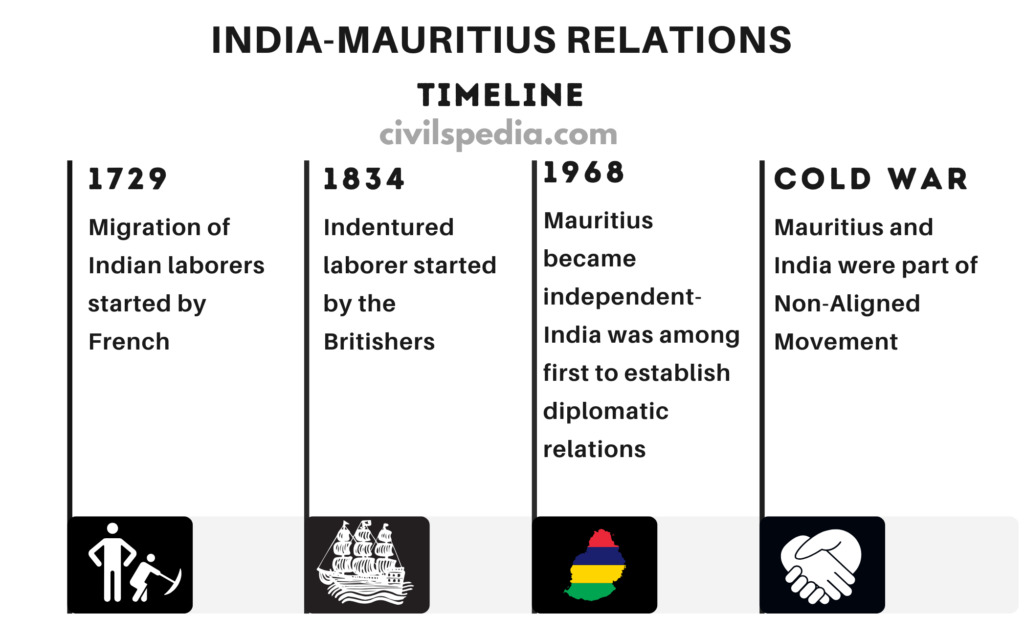
Early Contacts: Indian migration to Mauritius began under French rule in 1729 and intensified under British rule (1834–early 1900s) with the arrival of over half a million Indian indentured labourers. This laid the foundation for today’s large Indian-origin population.
Diplomatic Relations: India was among the first countries to establish diplomatic ties with independent Mauritius in 1968.
Shared Anti-Colonial Outlook: Both countries were active in the Non-Aligned Movement (NAM) and supported each other in anti-colonial and decolonisation efforts.
Defence
India is developing infrastructure, such as a runway and jetty in the Agalega Islands, to enhance surveillance and connectivity.
Mauritius is a key part of India’s “Necklace of Diamonds” strategy, aimed at countering China’s String of Pearls strategy. It offers India both political leverage and a logistical point in the Western Indian Ocean.
India has played a crucial role in developing the Mauritian Coast Guard, supplying patrol vessels, aircraft and training.
Economic Relations
Bilateral Trade: Trade increased from USD 206.76 million (2005–06) to USD 851.13 million (2023–24).
Indian exports: USD 778.03 million
Mauritian exports: USD 73.10 million
FDI Source: Mauritius remains a major source of FDI into India — about USD 175 billion since 2000 (roughly 25% of total inflows).
CECPA (2021): The Comprehensive Economic Cooperation and Partnership Agreement between India and Mauritius gives
Preferential access to 310 Indian export items
Preferential access to 615 Mauritian products, including speciality sugar, juices, alcoholic beverages and medical devices.
Local Currency Trade: Both countries have agreed to settle mutual trade in local currencies, reducing transaction costs.
Digital Public Infrastructure: Mauritius has joined India’s Digital Public Infrastructure initiatives, with the launch of UPI and RuPay card systems to enhance digital payments and financial inclusion.
Diaspora
Around 70% of Mauritius’ population is of Indian origin.
Indian migration began under French rule in 1729 and expanded under British rule (1834–early 1900s), when over half a million Indian indentured labourers arrived.
Two major political families of Indian descent — Jugnauths and Ramgoolams — have dominated Mauritian politics since independence in 1968.
Multilateral Forums
Indian Ocean Rim Association (IORA): India and Mauritius work closely within IORA to promote regional maritime security, trade facilitation, and blue-economy cooperation.
SAGAR Initiative: Mauritius is an important partner in India’s “Security and Growth for All in the Region” (SAGAR) vision for the Indian Ocean.
Africa Outreach: Mauritius serves as a strategic hub for India’s outreach to the African continent through development, trade, and capacity-building programmes.
Commonwealth Cooperation: Both countries coordinate positions within the Commonwealth of Nations on issues of democracy, development and small island states.
Other Cooperation
India supports Mauritius’ claim over the Chagos Archipelago, which remains under UK control. The UK has leased Diego Garcia (largest island) to the USA for a military base.
India is constructing the new Parliament building in Mauritius.
In 2025, India announced a plan to train 500 Mauritian civil servants over five years under a tailored capacity-building initiative.
Issues
Chinese Challenge: China’s growing footprint in the Indian Ocean (String of Pearls) raises security concerns for India and makes Mauritius strategically sensitive.
Tax & Investment Concerns: Mauritius has traditionally been a major route for FDI into India. Changes to the India–Mauritius Double Taxation Avoidance Agreement (DTAA) and stricter rules on “treaty shopping” have reduced inflows and created friction between businesses.
Delayed Project Implementation: Some Indian-assisted infrastructure projects in Mauritius have faced delays and cost escalations, creating local criticism.
Competition from Other Investors: Japan, France and Gulf countries are also stepping up their engagement with Mauritius, leading to more competition for Indian projects.
This article deals with ‘Biofuels – UPSC.’ This is part of our series on ‘Environment’, an important pillar of the GS-3 syllabus. For more articles on Science and technology, you can click here.
Introduction
Biofuels are renewable fuels made from biomass — organic materials such as plants, crop waste, used oils, animal waste, or industrial biowaste. Unlike fossil fuels like coal and petroleum, biofuels are cleaner and sustainable, releasing much fewer pollutants when burnt.
The two most common types of biofuels in use today are:
Ethanol (used with petrol)
Biodiesel (used with diesel)
Generations of Biofuels
Biofuels are categorized into four generations depending on the type of raw materials used and technology applied:
1G
– Biofuels are produced from food crops (leading to the Food vs. Fuel debate). – E.g., Ethanol produced from feedstock of sugarcane, cereals (rice, wheat, barley, corn & sorghum), sugar beet, etc.
2G
– Biofuels are produced from crop residues and non-food biomass (e.g., rice straw, wheat husk, bagasse) (it addresses food vs fuel debate, but the process is net carbon positive) – E.g., Ethanol produced from crop residues like wheat husk, rice straw
3G
– Biofuels are produced from Algae. They absorb CO₂ while growing and are net carbon neutral. – E.g., Ethanol produced from Microalgae.
4G
– Biofuels are produced from Genetically Modified Organisms. – Aim is to make the process net carbon negative and create artificial carbon sinks.
Ethanol
Ethanol (Ethyl Alcohol) is 99.9% pure alcohol.
It is manufactured from sugarcane, maize, and other sources with light starch content.
It is blended with petrol to reduce fossil fuel use and emissions.
The most common blend is E10 (10% ethanol + 90% petrol). India is aiming for E20 soon.
How is Ethanol Produced?
There are two main sources:
Sugarcane Juice / Molasses: Easier and cheaper to convert into ethanol.
Cereals like maize, rice, wheat: First require conversion of starch to sugar, hence more expensive and complex.
Benefits of Ethanol
Cuts fuel import bills — India can save ₹30,000 crore per year
Reduces carbon emissions and air pollution
Helps farmers by creating demand for sugarcane and waste crops
Creates employment and supports rural economy
Enhances energy security and reduces dependence on fossil fuels
Ethanol Policy Landscape in India
Ethanol Blending Program (EBP)
Launched: 2003
The target is to achieve:
10% blending by 2022 (achieved)
20% blending by 2025-26 (earlier 2030
National Biofuel Policy, 2018
Promotes ethanol production from diverse feedstocks, including sugarcane, maize, surplus rice, and damaged grains, with the aim of achieving 10% blending by 2022 and 20% blending by 2025-26.
Dr Rakesh Sarwal Committee Recommendations
Dr. Rakesh Sarwal’s committee was formed to suggest a roadmap for ethanol blending in India from 2020-2025.
It gave the following recommendations
Start using E10, i.e blending 10% Ethanol in Petrol from 2022.
Start using E20, i.e. blending 20% Ethanol in Petrol from 2025.
Invest in R&D for E20 compliant engines.
Provide tax subsidies to purchase E20-compliant vehicles.
The ultimate goal is E100 (i.e. Running a vehicle completely on ethanol, without petrol) in the future.
Other Measures
Budget 2022: ₹2/litre excise duty on unblended petrol
GST on ethanol reduced to 5%
PM-JIVAN Yojana: Viability gap funding for 2G bio-refineries
Challenges Ahead
Competing demands: Ethanol is also used in alcohol, pharma, and other industries
Water Stress: Sugarcane is a water-guzzling crop, and its production for producing Ethanol can cause irreparable damage to the water tables.
Cyclic sugar industry: Sugar industry is cyclic in nature due to availability of cane.
Food security: Diverting food grains for ethanol can impact food availability
Biodiesel
Biodiesel is a type of biofuel made from natural, renewable sources like vegetable oils, animal fats, or even used cooking oil. Unlike traditional diesel, which is made from crude oil (a fossil fuel), biodiesel is biodegradable, non-toxic, and produces much less pollution.
Benefits of Biodiesel
Reduces Greenhouse Gas Emissions: Biodiesel produces up to 75% less carbon dioxide compared to regular diesel.
Cleaner Air: It emits less particulate matter, sulphur, and carbon monoxide, improving air quality.
Can Be Used in Existing Engines: Biodiesel can be blended with regular diesel (e.g., B20 = 20% biodiesel + 80% diesel), requiring no major engine modifications.
Promotes Waste Management: Used cooking oil, which otherwise pollutes drains and soil, can be converted into biodiesel.
Supports Farmers: Raw materials for biodiesel like soybean, mustard, jatropha etc., can be grown by farmers — boosting rural incomes.
Challenges of Biodiesel
Food vs Fuel Debate: Using edible oils (like soybean or palm oil) for fuel can reduce food availability.
Limited Infrastructure: India still lacks large-scale facilities to produce and distribute biodiesel.
Seasonal Availability: Crop-based raw material supply is seasonal and dependent on monsoons.
India’s Initiatives
India launched the Biofuel Policy 2018, aiming to blend 5% biodiesel in diesel by 2030.
Focus on non-edible oil plants like Jatropha, grown on wastelands, is encouraged to avoid competition with food crops.
Side Topic: Jatropha Plant
Jatropha is a drought-resistant shrub that has gained attention in recent years for its potential as a biofuel crop, especially in countries like India.
Its seeds contain up to 30–40% oil, which can be converted into biodiesel
It is a hardy, non-edible plant that grows well on wastelands and marginal lands
Global Bio Fuel Alliance
Launched at the G20 Summit (held in India in 2023)
Led by India, the USA, and Brazil
Launched with nine initiating members–India, the US, Brazil, Argentina, Bangladesh, Italy, Mauritius, South Africa, and the United Arab Emirates. Now includes 29 countries & 14 international organisations
Aim: Promote global trade, cooperation, and sustainable use of biofuels
Can Biofuels Replace Fossil Fuels?
The search for alternatives to fossil fuels has brought biofuels into global focus due to their renewable nature and potential to reduce greenhouse gas emissions. However, the question remains: Can biofuels truly replace fossil fuels in a sustainable, equitable, and scalable manner?
Arguments in Favour of Biofuels as a Replacement:
Renewable and Cleaner: Biofuels like bioethanol and biodiesel are derived from organic materials and are biodegradable and reduce net carbon emissions, especially in the case of sugarcane-based ethanol
Energy Security: Biofuels offer countries like India a chance to reduce dependency on imported oil, thus improving energy security and supporting rural economic development through energy crop cultivation.
Use of Waste Biomass (2nd Generation Biofuels): These involve converting agricultural waste like stalks, husks, and bagasse into biofuel, offering a sustainable solution without compromising food security.
Challenges and Limitations of Biofuels:
Food vs Fuel Dilemma (1st Gen Biofuels): Using food crops like sugarcane, corn, and rice for fuel diverts resources away from food, worsening hunger and disproportionately impacting low- and middle-income populations, especially women and children.
Ecological Damage:
Deforestation for energy crop cultivation (e.g., in the Amazon) disrupts ecosystems.
Monoculture practices reduce biodiversity.
Water-intensive crops strain freshwater supplies in already water-scarce regions.
Socioeconomic Impact: Biofuel expansion has led to the displacement of indigenous communities and worsened climate variability in some regions.
While biofuels have a role to play in reducing fossil fuel use, they cannot fully replace fossil fuels without addressing serious challenges related to food security, ecology, emissions, and social justice. Thus, biofuels should be part of a broader energy transition strategy that includes solar, wind, hydrogen, and energy efficiency measures.
Climate Change Frameworks – Kyoto Protocol and Paris Climate Deal
This article deals with ‘Climate Change Frameworks – Kyoto Protocol and Paris Climate Deal – UPSC.’ This is part of our series on ‘Environment’, an important pillar of the GS-3 syllabus. For more articles on Science and technology, you can click here.
India’s Stand on Climate Change
Stand 1: India wants developed countries to reduce their carbon space for developing countries to grow. For example, India’s per capita carbon emissions are one-third of the global average. Hence, developed countries should reduce their carbon emissions so that developing countries can grow.
Stand 2: Since India’s contribution to the world’s cumulative emissions is less than 4%, it should be provided a greater share of the remaining carbon budget. Simultaneously, developed countries should strive towards sustainable consumption, acknowledging their historical consumption of carbon budget.
Part 1: Kyoto Protocol
United Nations Framework Convention on Climate Change (UNFCCC)
UNFCCC is an inter-governmental treaty that opened for signature at the ‘Rio Earth Summit’ in 1992 and entered into force in 1994.
Objectives of UNFCCC
Stabilize the GHG concentration in the atmosphere to prevent dangerous anthropogenic interference with climate systems.
Ensure global food production is not threatened.
Enable sustainable economic development.
Operating Mechanism of UNFCCC
Conference of Parties (COP): All the countries that are parties to the convention meet every year at the Conference of Parties, which acts as the supreme decision-making body of the convention.
Conference of the Parties serving as the meeting of the Parties to the Kyoto Protocol (CMP): It oversees the implementation of the Kyoto Protocol.
Conference of the Parties serving as the meeting of the Parties to the Paris Agreement(CMA): It oversees the implementation of the Paris Agreement.
What is Kyoto Protocol?
The Kyoto Protocol is an international treaty established as a result of the 3rd Conference of the Parties (CoP) to the United Nations Framework Convention on Climate Change (UNFCCC) held in Kyoto, Japan, in 1997.
Its primary objective is to address the issue of global warming by setting specific targets for industrialized nations to reduce their greenhouse gas (GHG) emissions.
The protocol sets a target for industrialized countries to collectively reduce their GHG emissions by approximately 5.2% below the levels recorded in 1990.
Kyoto Protocol came into force after the required number of Annex 1 Countries (industrialized nations) ratified it. This milestone was achieved in 2008.
The Kyoto Protocol’s first commitment period was from 2008 to 2012.
Common But Differentiated Responsibilities (CBDR)
CBDR suggests that while all nations share the common responsibility to reduce GHG emissions, there should be a distinction in the burden between developed and developing countries.
Developed nations, being historical culprits, bear a greater responsibility for emission reduction.
The Kyoto Protocol follows this principle.
Annex under Kyoto Protocol
Annex refers to additional information provided at the end of a book or treaty.
Side Topic: More about GHGs
Gas
Global Warming Potential
Lifetime yrs
Relative Contribution to Global Warming
CO2
1
50-200
60%
CH4
21
12
20%
Nitrous oxide
310
120
6%
HFCs
140-1200
1-270
14%
PFCs
6500-9200
800-50,000
Rank 5
SF6
23,900
3200
Rank 6
How the Kyoto Protocol really works
Under the Kyoto Protocol, every Annex 1 country was given a specific number of Kyoto Units called Target Quota. E.g. in 2009, Australia was given approximately 3 Billion Kyoto units (1 Kyoto Unit= 1 ton of CO2)
If Australia limits their emissions within the target range, everything is well & good. The approach of the Australian government should be to take all steps so that they don’t cross the quota. E.g.
They can promote Solar energy and wind energy.
Increase tax on polluting vehicles and industry.
Make strict Anti-pollution laws.
But if the country fails to limit GHG emissions within Target Quota, then the country will have to buy additional units from another country. Kyoto Protocol has 3 mechanisms for this.
#1 Emission Trading
Each Annex 1 country gives a fixed quota to companies.
Suppose an Iron factory was given 10 tons of GHG.
Tyre company was also given 10 tons of GHG.
If the tyre company owner increases the efficiency and uses less than given Kyoto Units, he will have some spare quota. Suppose the Iron Company owner needs more Quotas due to an increase in demand or any other factor. In this case, the Iron company owner can purchase the spare quota of the Tyre company. It is called Emission trading.
Countries in Annex 1 can also do the same thing at national level if they think that they are breaching the limits.
#2 Clean Development Mechanism (CDM)
Suppose an Annex 1 country like the UK is given a quota of 500 units but emits 520 units of GHG. In this case, the UK can finance a solar or wind project in India or any other non-annex country. They will get a certificate that it led to a reduction of 20 units of GHG to remain within their limit.
Companies in Annex 1 country can also do the same thing if that company is breaching their limit.
#3 Joint Implementation (JI)
JI operates similarly to CDM but involves Annex 1 countries conducting emission reduction projects in other Annex 1 countries.
In this context, the UK could initiate a beneficial project in another Annex 1 country, such as Australia, to offset excess emissions and earn certified emission reduction credits.
Time Frame
1992
Earth Summit was held in Rio de Janeiro, and UNFCCC came into being.
The Kyoto Protocol came into force, but the US, the largest polluter at the time, did not ratify it (alleging that it would impact its economic interests negatively since China and India were not obliged to reduce their emissions)
2009
The Copenhagen Accord was signed at CoP-15, held in Copenhagen, where it was agreed that all countries (including developing countries) should pledge to reduce GHG emissions. However, all of the pledges made under the Copenhagen Accord were voluntary.
2011
Canada becomes the first country to quit the Kyoto Protocol, arguing its flaws and the exclusion of major emitters like the USA and China.
2015
COP21 in Paris delivers the Paris Agreement as successor to the Kyoto Protocol.
4 Nov 2016
Paris agreement entered into force, 30 days after being ratified by at least 55 countries representing 55% of global greenhouse gas emissions.
Part 2: Paris Climate Agreement
The Kyoto Protocol, established in 1997, marked the initial step in creating a framework for binding emission reduction commitments primarily for developed nations. However, it faced significant challenges, including the absence of major emitters like the United States and China.
The limitations of the Kyoto Protocol underscored the need for a more inclusive and flexible approach that could garner global participation. The Paris Climate Agreement, adopted in 2015 during the 21st Conference of the Parties (COP21), emerged as the successor to the Kyoto Protocol.
Outcomes of Paris Climate
Limit Global Warming
Under the Paris Climate Agreement, 196 nations pledged to collaborate in efforts to restrict global warming, aiming to cap temperature increases at 2 degrees Celsius, with a stretch goal of keeping below 1.5 C (Compromise between Developed nations demanding 2 degrees & Small Island nations demanding 1.5 degrees Celsius).
Emission Cuts
Emission Cuts: There is no distinction between Developed & Developing nations wrt emission cuts. Every nation has to cut emissions based on its capability, known as its Nationally Determined Contributions. But there are no penalties for failing to achieve these targets
Global Stocktake (Pledge Review): ‘Global Stocktake’ is a ‘five-yearly review’ of a country’s climate change actions. The first global stocktake happened in 2023.
Principle of Progression: Revised targets (after a period of 5 years) can’t be less than targets already submitted. At each round of review, there is an expectation of higher ambitions.
Finance
Financial Commitment: Developed countries pledged to provide $100 billion annually from 2020 to address climate change issues. Developed countries have succeeded in inserting a provision asking developing countries to also raise financial resources, even as a voluntary effort.
Balanced Allocation: Allocation of finances has to be balanced between the mitigation & adaptation needs of developing countries
Regarding Concept of Common But Differentiated Responsibility
CBDR Diluted: There is no differentiation between developed and developing nations regarding emission reductions, although distinctions remain in terms of finance and capacity building. Each nation is required to reduce emissions based on its capabilities, indicating a dilution of the CBDR principle. Although CBDR still figures, historical responsibility finds no mention in the text.
Nationally Determined Contribution (NDC)
Intended Nationally Determined Contribution (INDC) is each country’s self-declared plan to cut greenhouse gas (GHG) emissions and adapt to climate change. It follows a bottom-up approach, shaped by national circumstances and capacity, aiming collectively to limit warming to 1.5–2°C above pre-industrial levels.
NDCs are submitted before ratifying the Paris Agreement; once ratified, they become NDCs (Nationally Determined Contributions) and are legally binding under international law.
They are applied equally to both developed and developing countries when ratified.
UNFCCC Ratcheting Mechanism
NDCs must be submitted and updated every 5 years, as per the Paris Agreement’s ratchet mechanism
In line with this, countries were urged to strengthen their 2030 targets by 2022. India responded by submitting its updated NDC in August 2022
India’s NDC
Drawing inspiration from Gandhi—”Earth provides enough for everyone’s need, not for everyone’s greed”—India’s climate targets have grown more ambitious:
Commitment
Original INDC 2015
Updated NDC 2022
Emission Intensity
33–35% reduction (2005–2030)
45% reduction (2005–2030)
Non-fossil Energy Share
40% of power capacity
50% of installed capacity by 2030
Carbon Sink
2.5–3 billion t CO₂ eq
Same
Additional qualitative commitments include promoting sustainable lifestyles, climate resilience in vulnerable sectors, and financing mechanisms.
As of July 2025, more than 50% of India’s electricity generation capacity comes from non-fossil fuel sources. Hence, India has achieved commitment #2 five years ahead of schedule.
Failures of the Paris Deal
Commitments are voluntary, lack penalties for non-compliance, and set no clear trajectory for limiting global warming below 2 degrees Celsius.
The Paris Deal is not legally binding in its entirety, diminishing its effectiveness in ensuring adherence to commitments.
The commitments of rich countries are not enough to meet their historical obligations. US comes in for particular blame (26-28% than 2005 levels)
The Paris Agreement calls for decarbonization but doesn’t distinguish between fossil carbon and dynamic forest carbon. Fossil carbon is generally static, whereas trees & forest carbon, which is in an active carbon pool (atmosphere & biosphere), can be easily released through activities such as forest fires
The promise of contributing $100 bn annually to the Green Climate Fund by developed countries is enormously short of what is needed.
Carbon Border Adjustment Mechanism (CBAM)
The European Union (EU) realized a problem: its domestic industries had to follow strict carbon emission rules under the Emissions Trading System (ETS). But imported goods—say, steel from India or cement from China—are not held to the same standards. This created what’s called “carbon leakage”: industries moved production to countries with looser rules to escape EU climate costs.
To address this issue, the EU introduced CBAM
It proposes a carbon tax on imports of carbon-intensive goods like steel, cement, aluminium, fertilisers, and electricity starting from 2026.
Importers in the EU will have to equal to the amount of carbon emissions embedded in the goods they bring in. If the product has already been taxed for carbon in the country of origin, that amount will be deducted.
The main idea is to ensure that foreign manufacturers do not get an unfair advantage over EU companies.
The EU argues this levels the playing field.
Concerns of Developing Countries like India:
Violates “Common But Differentiated Responsibilities” under the Paris Agreement.
Seen as a trade barrier that hurts exports from developing nations.
Unilateral in nature – introduced without global consensus.
Global Stocktake
The Global Stocktake (GST) is a formal process under the Paris Agreement to assess whether the world is on track to meet its climate goals, especially the goal of limiting global warming to well below 2°C, preferably 1.5°C.
It was agreed in the Paris Agreement (2015) that such a review would take place every 5 years, with the first-ever stocktake conducted in 2023 during the COP28 in UAE.
The process looks at the collective progress of all countries (not individual country performance) and aims to inform future Nationally Determined Contributions (NDCs).
Key Highlights of the 2023 Global Stocktake
The report confirmed that the world is currently off track to meet the Paris climate targets.
To limit warming to 1.5°C, global greenhouse gas (GHG) emissions must be reduced by 43% by 2030, compared to 2019 levels.
Major Developments
COP / Event
Year & Location
Major Outcomes / Highlights
COP21 (Paris)
2015, Paris
Paris Agreement adopted — goal to limit warming to well below 2°C, pursue 1.5°C; NDCs introduced; universal participation.
COP22 (Marrakesh)
2016, Morocco
Marrakech Action Proclamation to implement Paris Agreement; established “Marrakech Partnership” for climate action.
COP23 (Bonn)
2017, Germany (Fiji presided)
Fiji-led COP; advancement on rulebook development; focus on vulnerable countries and adaptation.
COP24 (Katowice)
2018, Poland
Katowice Climate Package adopted — detailed rulebook for Paris Agreement operationalisation; transparency guidelines agreed.
COP25 (Madrid)
2019, Spain
Delayed decisions on carbon markets (Article 6); calls for increased ambition; discussions on loss & damage finance.
COVID-19 Pandemic Impact
2020
COP26 postponed to 2021; many countries re-assessed climate ambitions.
COP26 (Glasgow)
2021, UK
Glasgow Climate Pact: phase down coal, boost finance to developing countries, methane reduction pledge, Article 6 carbon market rules agreed.
U.S. Rejoins Paris Agreement
2021
U.S. formally rejoins Paris Agreement, submitting updated NDC with higher targets.
COP27 (Sharm El-Sheikh)
2022, Egypt
Established loss and damage fund for vulnerable countries; focus on adaptation finance; continued dialogue on mitigation.
COP28 (Dubai)
2023
First Global Stocktake to assess collective progress; called for urgent action to close gaps in emissions reductions.
COP29 (Baku)
2024, Azerbaijan
– New Collective Quantified Goal (NCQG) on climate finance: mobilize $1.3 trillion/year by 2035, immediate $300B/year commitment. – Operationalization of Article 6.4 carbon market mechanism under UN oversight. – Loss & Damage Fund operationalized. – Launch of “Baku Dialogue on Water for Climate Action.”
Last Updated: July 2025 (Numismatics (UPSC Notes – Ancient History))
Table of Contents
Numismatics (UPSC Notes – Ancient History)
This article deals with ‘Numismatics (UPSC Notes – Ancient History)’ . This is part of our series on ‘Ancient History’ which is important pillar of GS-1 syllabus . For more articles , you canclick here.
Relevance to UPSC Syllabus
Prelims: Ancient History – factual details like coin types, dynasties, symbols, trade links.
GS Paper I – Mains:
Art & Culture – artistic quality of coins (Gupta coins = golden age of numismatics).
Ancient Indian History – political, social, economic, and religious developments.
Essay or Optional History Paper: Coins as material evidence to build historical narratives.
In this article, we will study the overview and basic concepts related to Numismatics in Ancient India, including the origin, evolution, and significance of coinage. The detailed analysis of coinage systems of individual dynasties—such as the Mauryas, Satavahanas, Kushanas, Guptas, and others—will be covered separately in their respective articles.
Introduction
Numismatics is the study of coins.
Coins are more than just currency, they are tiny time capsules offering deep insights into our history, politics, economy, religion, and art. Numismatics turns coins into storytellers.
Coins weren’t always around. So let’s begin at the beginning—when India had no coins at all.
Indian Coinage history
1. The Pre-Coin Era: Barter & Beginnings
1.1 Stone Age
No coins or currency.
Exchange of goods occurred via barter system.
1.2 Chalcolithic Cultures (Copper Age)
Continued reliance on barter trade.
1.3 Harappan Civilization (~2600–1900 BCE)
Had extensive trade, including overseas (Mesopotamia), but no coinage.
Trade was still barter-based, possibly aided by weighing stones and seals.
1.4 Vedic Period (1500–600 BCE)
Early Vedic texts like the Rigveda mention Nishka and Nishka-Griva—gold ornaments—but these cannot be equated with coins.
2. Birth of Coinage: 6th Century BCE
The emergence of states (Mahajanapadas) and urban centres in the 6th century BCE created the need for a standard medium of exchange—thus began Indian coinage.
3. Evolution of Indian Coins
3.1 Punch-Marked Coins (from 6th Century BCE)
These were the first coins used in India.
Mostly made of silver, but a few were of copper.
The metal was cut into pieces, and then different symbols were stamped (punched) onto them using tools.
These coins had no writing or names—only symbols like sun, animals, or trees.
They are called Karshapanas in old Buddhist texts written in Pali.
These coins were used widely in North India, and in some parts of South India, they were used for an even longer time.
3.2 Uninscribed Cast Coins
These came soon after punch-marked coins.
The method changed: instead of cutting and punching, metal was melted and poured into clay or metal moulds to make the coins.
These coins were also without writing—they had shapes or symbols, but no names or words.
Found in most parts of India, except the deep South.
3.3 Die-Struck Coins (from 2nd Century BCE)
This was a new and advanced way of making coins.
Metal pieces were pressed (struck) using dies to create clear designs and images on both sides of the coin.
Indo-Greek Coins
These were the first coins made using the die-struck method in India.
Usually round and made of silver.
One side (front) had the portrait (face) of the king, and the other side (back) had religious or cultural symbols.
These coins were the first to have writing—they included the king’s name and titles.
Showed realistic artwork, with clear details on the king’s face and dress.
Kushana Coins (1st to 4th Century CE)
The Kushana kings were the first in India to issue gold coins on a large scale.
They also made silver and big copper coins.
One side of the coin had the image, name, and title of the king.
The other side showed gods and goddesses from many religions—Hindu, Buddhist, Greek, and Zoroastrian. This tells us that India was a religiously diverse land, and people followed different faiths peacefully.
The large number of coins shows there was a strong money-based economy, and India had active trade with other regions.
Satavahana, Western Kshatrapa, and Roman Coins in the Deccan (Central-South India)
Satavahana coins had local symbols, and some even had the picture of a ship, which shows that sea trade was important in the Deccan region.
Western Kshatrapa coins also followed the die-struck method and had bilingual inscriptions.
Roman coins were found in large numbers in South India. These were not made in India but came here through foreign trade, especially with the Roman Empire. This proves that India had active trade relations with Europe, even 2000 years ago.
Imperial Gupta Coins (4th to 6th Century CE)
The Guptas issued some of the most beautiful gold coins in Indian history.
These coins had images of kings performing rituals, especially the Ashvamedha Yajna (horse sacrifice).
They also had mythological scenes, such as gods and goddesses.
The coins had clear writing in Sanskrit, showing that the language and script had become standardized.
Gupta coins are often called the golden age of Indian numismatics because of their beauty and artistic value.
Coins as Source of History
Coins may look small and ordinary, but they tell us a lot about ancient India. Historians treat coins like puzzle pieces that help build the picture of our past.
Language and Script
The writing on coins helps us understand which languages and scripts were used during that time. For example, Greek, Brahmi, and Kharosthi scripts appear on Indo-Greek coins.
Coins help us track the development of scripts like Brahmi into later Indian languages.
Economy and Trade
The number and spread of coins show how much trade happened in that period. For example, a large number of Kushana gold coins tells us that trade was booming.
Satavahana coins with pictures of ships prove that people were doing sea trade, especially in the Deccan region.
Roman coins found in India show that India had strong trade links with the Roman Empire.
Archaeology and Dating
When archaeologists find coins while digging, they use them to determine the age of the layers (strata) where they are found.
Political History and Empire Boundaries
Coins tell us about kings and rulers—even those who are not mentioned in texts. For example, many Indo-Greek kings are known only through their coins.
Coins also show the area of circulation, which helps us guess the size of their kingdom. But we have to be careful—since coins travel through trade, they can reach places beyond the king’s control.
Type of Government (Polity)
Some coins mention the word “Gana”, which means republic or group. For example, Yaudheya and Malava coins mention “Gana”, so historians believe these were republican states, not monarchies.
Some coins are named after cities like Ujjayini or Taxila.This shows that certain cities had power to issue coins, meaning they might have had some local self-governance.
Biographical Details
Sometimes coins give us personal details about rulers that we don’t find in texts.
For example:
Chandragupta I’s marriage to a Lichchhavi princess is known only through a commemorative coin.
Samudragupta and Kumaragupta I issued coins showing them performing the Ashvamedha Yajna (horse sacrifice)—telling us about their ritual practices and power.
Religious Beliefs and Practices
Many coins show deities (gods and goddesses). This helps us understand what religion the king followed and what religious symbols were popular at that time.
For example:
Kushana coins show gods from Hinduism, Buddhism, Zoroastrianism, and Greek mythology.
Indo-Greek king Agathocles issued coins showing Krishna and Balarama, proving that the cult of these deities was active in that region (present-day Afghanistan) in the 2nd century BCE.
Military Insights
Some coins show kings with weapons, bows, or in battle poses. This helps us understand how rulers wanted to project themselves as strong warriors or military leaders.
For example, some Gupta coins show Samudragupta playing the Veena (symbol of culture) while others show him performing rituals and holding weapons—showing a balanced image of a king.
Last Update: July 2025 (Neolithic Age (UPSC Notes – Ancient History))
Table of Contents
Neolithic Age (UPSC Notes – Ancient History)
This article deals with ‘Neolithic Age (UPSC Notes – Ancient History)’ . This is part of our series on ‘Ancient History’ which is important pillar of GS-1 syllabus . For more articles , you canclick here.
Introduction
The Neolithic Age, or New Stone Age, marks a major turning point in human history. It was a time when humans transitioned from hunting and gathering to agriculture and settlement, leading to the rise of villages, crafts, pottery, and eventually civilizations.
Early evidence of Neolithic culture is found in the Fertile Crescent region of Egypt and Mesopotamia, the Indus region, the Ganges valley of India, and China.
Relative Chronology: In the Indian Subcontinent, Neolithic period can be placed between 5,000 BCE to 1,500 BCE.
The oldest Neolithic cultures are found in the north-western part dating c. 7000 BCE. One of the most important site is Mehrgarh.
The Neolithic sites of the central India can be traced back to 4000 to 5000 BC.
In the other parts like Northern Neolithic (Kashmir), Eastern Neolithic (Assam, Bihar) and Southern Neolithic, it can be traced back to 2500 to 1500 BC.
Neolithic Age in India is generally associated with:
Food production
Pottery
Sedentary village life
Neolithic Revolution
The Neolithic Revolution refers to the profound changes brought about by the shift from a nomadic and hunter-gatherer lifestyle to a settled and agricultural way of life.
Key developments:
Domestication of plants (like wheat, barley, rice) and animals (like cattle, sheep, goats).
Art and decoration flourished (e.g., figurines, decorated pots)
This period set the foundation for all future human civilizations.
Tools Associated
Neolithic tools were more advanced than those of the Palaeolithic and Mesolithic periods.
Grinding and polishing of tools started. Grounded and polished tools are known as Celts.
Types of tools included
Agricultural Tools: Sickles, hoes, and ploughs for farming.
Grinding Tools: Mortars and pestles for processing grains.
Weapons: Axes, spears, and arrows for hunting and protection.
Climate
The Neolithic period coincided with the Holocene epoch, characterized by a relatively stable and warm climate.
Subsistence Pattern
Domestication of Plants and Animals: The Neolithic Age marked the beginning of agriculture in India, with the domestication of plants and animals.
Hunting and Gathering Continued: While agriculture became dominant, hunting, gathering, and fishing continued as supplementary subsistence activities.
Side Topic: What is Domestication
Domestication can happen in both plants and animals.
Plant collection means gathering wild grains and eating them all. Plant domestication begins when some grains are saved and planted for the next season.
Animal keeping is when people capture and keep wild animals. Animal domestication happens when animals are bred and raised by humans under controlled conditions for use or profit.
Settlement Patterns
Permanent Habitations: People built permanent houses using materials like mud bricks, wood, and stone.
Rural Settlements: The Neolithic Age saw the emergence of rural settlements, which later evolved into urban centers during the Chalcolithic and Bronze Ages.
Important Neolithic Cultures
The Neolithic cultures of India are divided into various regional cultures and they flourished in different time periods
1. North-Western India
The earliest evidence of the domestication of plants and animals is found in North-Western India.
Important Neolithic Sites include Mehrgarh, Sarai Khola, Rana Ghundai, and Jalilpur (all in Pakistan now)
The site of Mehrgarh (located in the Bolan Valley of Baluchistan) is the most important as
The earliest evidence of Neolithic times dating c. 7000 BCE comes from this site.
Evidence suggests that cattle, sheep and goats were domesticated, and wheat and barley were cultivated.
Pottery (both handmade and wheel made) was used.
Beadmaking was practiced. Beads were made from semi-precious stones such as lapis lazuli, turquoise, and agate, as well as of terracotta and shell.
Evidence of Lapis Lazuli, a semi-precious stone not found locally, points toward presence of trade.
People buried the dead and grave goods such as ornaments have been found.
2. Kashmir
Neolithic culture of Kashmir was contemporary to the Indus Valley Civilization.
The sites include Burzahom, Gufkral and Pampora which lies in the Karewa zone.
Most important site is Burzahom with following characteristics
Pit Houses: People lived in Pit Houses below the earth to escape the cold weather.
Domestication: Sheep and goats were domesticated, and plants were cultivated.
Trade with Harappans: They traded with Harappans.
Pottery: Mostly, handmade pottery was used.
Tools: Wide variety of stone and bone tools were used including perforated ‘harvesters.’
Burials: Humans were sometimes buried with animals such as deer, leopard, sheep, goat etc. An interesting find is the dog buried with humans suggesting dog might have been buried with his master.
3. Ganga Valley and Central India
Neolithic Cultures of Ganga Valley and Central India are found at Lehuradeva, Chopani Mando, Mahagara and Damdama
Important characteristics of Neolithic sites in Ganga Valley and Central India include
Evidence of plant and animal domestication.
Early evidence of rice cultivation is also found.
Pottery with cord impression was used.
4. South India
Important Neolithic sites in South India include
Karnataka: Brahmagiri, Maski, Piklihal and Hallur
Andhra Pradesh: Utnur, Nagarjunakonda and Ramapuram
Tamil Nadu: Paiyyampalli
Important feature of Neolithic sites in South India include ash mounds in the centre with settlements around them. Studies have revealed that ash is of burnt cow dung (but the exact function remains unknown).
5. Other
Kucha (Odisha), Sarutaru, Daojali Hading, and Marakdola (Assam) show early Neolithic settlements in the East and North-East India.
Last Updated: July 2025 (Jainism (Ancient History-UPSC Notes))
Table of Contents
Jainism (Ancient History-UPSC Notes)
This article deals with ‘Jainism (Ancient History-UPSC Notes)’ . This is part of our series on ‘Ancient History’ which is important pillar of GS-1 syllabus . For more articles , you canclick here.
Introduction
Jainism, one of the oldest philosophical and religious traditions of India, offers a rich and deeply ethical worldview grounded in non-violence, self-realization, and the pursuit of liberation (moksha). For UPSC aspirants, understanding Jainism is crucial, particularly for the Prelims under Ancient and Medieval History, and for Mains under Indian Philosophy, Society, and Religion.
Mahavira: Life and Legacies
In c. 300 BCE, the Jaina community was split into two main sects i.e. Digambara (“sky-clad”) and Shvetambara (“white-clad”). Both sects developed different hagiographies (life stories) of Mahavira. They agree on some aspects but differ on others.
Birth and Early Life
Year: 599 BCE (agreed by both sects)
Place: Kundagrama, near Vaishali (capital of Videha)
Father: Siddhartha – Chief of the Jnatri clan
Mother: Trishala – Sister of the king of Videha
Shvetambara version: Mahavira was originally conceived by a Brahmana woman named Devananda, but Indra (Shakra) transferred the embryo to Trishala’s womb, because a Brahman woman or one from low family was not worthy of giving birth to future Tirathankara . The significance lies in the interpretation, not the story itself.
Renunciation
Both sects have their own versions
Shvetambara:
He had extraordinary concern for ahimsa even before his birth. Hence, he laid absolutely still in Trishala’s womb so as to not cause her any pain & discomfort
He realised that how easy it is to cause parents pain & anxiety, Vardhamana vowed there and then not to renounce world as long as his parents are alive
He renounced when he was aged 30 after his parents death
Digambara:
Renounced the world at 30 while his parents were still alive, but with their permission.
Marriage
Both sects have differences
Shvetambara: Married Yashoda and had a daughter, Priyadarshana.
Digambara: Never married.
Enlightenment
Both sects agree on the Enlightenment.
He practiced severe austerities for 12 years.
Attained Kevalajnana (infinite knowledge) near Jambhikagrama, on the banks of the Rijupalika river.
Post-Enlightenment Life
Both sects have differences here
Digambara:
Mahavira freed from defects of ordinary human existence such as hunger, thirst, sleep & disease. He no longer engaged in mundane activities & sat fixed
Task of teaching was that of Gandharas (chief disciples ) . First disciples were Brahmin named Indrabhuti Gautama & his two brothers. Hence, sangha was created & later it expanded
Shvetambara:
Mahavira actively travelled and taught his doctrine himself.
Death
Both traditions agree that he died at Pava/Papapuri (near modern-day Patna) at the age of 72 in 527 BCE.
This marks the start of the Vira-nirvana Era (used as a calendar by Jainas).
Jain Councils: Codifying the Faith
The evolution of Jainism was not just spiritual but also institutional. Key efforts to preserve and organize the vast oral teachings of Jainism culminated in two major Jain councils, each marking a turning point in the development of the religion’s doctrinal framework.
First Jain Council (c. 300 BCE) – Pataliputra
Venue: Pataliputra (modern-day Patna, Bihar)
Presided by: Sthulabhadra, a senior monk and contemporary of Bhadrabahu
Royal Patronage: Likely convened under the auspices of Chandragupta Maurya, who had embraced Jainism late in life under Bhadrabahu’s influence
The council was held in the aftermath of a devastating famine that had caused a major migration of monks to southern India. When the monastic community regrouped, there were concerns about the dilution of teachings. As a response, Sthulabhadra and his associates compiled the Jaina canon into 12 Angas (primary sections). However, this codification was accepted only by the Shvetambara sect. The Digambaras did not recognize it, maintaining that the original teachings were lost during the migration and famine.
Second Jain Council (c. 512 CE) – Vallabhi
Venue: Vallabhi (in present-day Gujarat)
Presided by: Devardhigani Kshemasramana, a prominent monk of the Shvetambara sect
Royal Patronage: Not clearly documented, though it likely had the support of regional monarchs of western India
This council was exclusively Shvetambara and was called to further compile and preserve Jain scriptures that were at risk of being forgotten. The existing canon was reaffirmed, and additional texts, known as Upangas (secondary texts), were appended to the main corpus. These texts offered interpretations, narratives, and commentaries crucial for ritual and philosophical understanding.
Jainism Philosophy
Jaina Doctrine is much older than Buddhist Doctrine (but difficult to ascertain exact dates). Buddha & Mahavira were contemporaries & there are similarities in some of their teachings e.g. rejection of authority of Vedas , emphasis on renunciation & human efforts to attain salvation, establishment of monastic order for men & women.
Pancha Mahavratas
Mahavira accepted most of the religious doctrines laid down by Parsvanatha. However, he made some alterations and additions to them. The five doctrines of Jainism (five vows), known as Panchamahavratas, are for the monks.
4 doctrines advocated by Parsvanatha
Ahimsa (Non-violence) – Absolute abstention from causing harm to any living being, in thought, word, or deed.
Satya (Truthfulness) – Commitment to speaking the truth without distortion or deceit.
Asteya (Non-stealing) – Refraining from taking anything that is not willingly given.
Aparigraha (Non-possession) – Renunciation of material wealth and attachments.
5th Doctrine: Mahavira retained all four of Parsvanatha’s vows but introduced a fifth and more rigorous vow:
Brahmacharya (Celibacy or Chastity) – This went beyond mere control of desires and required complete celibacy, even in thought. For Mahavira, spiritual progress was impossible without strict restraint over sensory pleasures.
These were to be observed in their strictest form by Jaina monks and nuns, while lay followers were expected to follow Anuvratas—less intense versions of the same vows adapted to household life.
Doctrines of Truth and Perception
Anekantavada: Reality is manifold and complex. Different perspectives reveal different facets of truth.
Syadavada: No statement is absolutely true. Truth depends on context, condition, and perspective. Thus, every statement is qualified by the phrase “syat” (maybe).
Together, these doctrines reject absolutism and advocate for intellectual tolerance and philosophical humility.
Nature of the Jiva (Soul)
Jainism posits an infinite number of jivas (souls), each with inherent qualities:
Chaitanya (consciousness)
Sukha (bliss)
Virya (energy or power)
Jiva has no fixed shape and becomes co-extensive with the body it inhabits—like light filling a room.
Karma and Transmigration
Karma in Jainism is a physical substance—minute particles that attach to the jiva due to passions (kasayas) like anger, pride, deceit, and greed.
The most harmful karmas are mohaniya karmas (deluding karmas), which obscure the true nature of the jiva.
These karmas distort the soul’s inherent qualities and lead to bandha (bondage).
Liberation Process
Some jivas possess bhavyatva—an innate potential to attain liberation.
Liberation involves two main steps:
Samvara: Blocking the influx of new karma through right conduct and restraint.
Nirjara: Gradual shedding of existing karma through austerity and self-purification.
When all karmic particles are removed, the jiva attains moksha—a state of pure knowledge, bliss, and infinite energy.
Jina & Tirthankara
Jaina means follower of Jina which means victor, a person who has attained infinite knowledge and teaches others how to attain moksha, i.e., liberation from the cycle of rebirth.
Tirthankara is another word for jina and means ‘ford builder,’ i.e., one who builds fords that help people across the ocean of suffering.
Concept of Time
Time is cyclic and divided into two half-cycles:
Utsarpini: Ascending arc – a progressive phase where happiness increases.
Avasarpini: Descending arc – a regressive phase with increasing sorrow.
These half cycles last vast span of time & further divided into 6 stages known as Kalas
There are supposed to be 24 Tirathankaras in each half cycle to guide beings to liberation.
Jaina Tirathankaras in present half cycle
Present half cycle is Avasarpani ie regressive happiness period
First tirathankara of this age => Rishabadeva
Historicity of most of the tirathankaras are not easy to ascertain .
22
Neminatha
Belong to Saurahtra region of Gujarat
23
Parshavanatha
Lived in Benaras
24
Vardhamana aka Mahavira
the most historically verifiable and prominent Tirthankara.
Jaina Discipline
Triratna (three gems) of Jainism consists of
Right Faith (Samyag-Darshana)
Right Knowledge (Samyag-Jnana)
Right Conduct (Samyag-Charitra)
Ahimsa is central to Jainism, and it is the first vow for renunciants as well as the laity. The extent to which Jainas carry this principle is connected to their idea of different forms of life.
Jaina doctrine recognizes four main forms of existence—of gods (deva), humans (manushya), hell beings (naraki), and animals and plants (tiryancha).
Animal and plant category is further sub-divided into smaller sub-categories on the basis of their sense faculties. The lowest category comprises the single-sense bodies (ekendriya).
Renunciant is supposed to take the observation of ahimsa to a higher level in his daily living.
Laypersons are supposed to avoid harming beings with two or more senses
But the renunciant is supposed to refrain from harming even single-sense beings (ekendriya) and element bodies (sthavara). Monks and nuns must not dig the earth, lest they kill earth bodies. They must avoid bathing, swimming, or walking in the rain, lest they kill water bodies. They must not light or extinguish flames, to avoid harming fire bodies. They must not fan themselves, to avoid harming air bodies
Of the differences in daily practices between Digambara and Shvetambara monks, the most important relates to clothing. Both traditions agree that Mahavira and his early disciples had moved around naked. The Digambaras follow that tradition strictly. According to them, a monk must renounce all possessions, including clothes. The only things a monk can carry are a small broom for brushing insects away before sitting down and a water gourd (kamandalu) for toilet hygiene. The Shvetambaras, on the other hand, wear white robes; they view nudity as a practice that had fallen into abeyance and was now unnecessary.
Jaina texts list six occupations—governing (asi), writing (mashi), farming (krishi), the arts (vidya), trade (vanijya), and the practice of various crafts (shilpa). Of these, governing and agriculture potentially involve injuring life (insects are destroyed while tilling the soil, while governing can involve warfare) and therefore tend to get ruled out. Trade is likely to cause less injury and it remains a preferred occupation for Jainas even today.
Social Composition of Jaina Sangha & Laity
Kshatriya Superiority
Jaina texts reflect the idea of Kshatriya varna’s superiority over others.
These texts criticize Brahmanas, their rituals, and their arrogance.
Caste Inclusivity and Practice
Theoretically, people from all varnas could enter the sangha. For instance, Uttaradhyayana Sutra narrates story of Harikeshiya—a monk from a Chandala background.
Notwithstanding the theoretical position, key disciples of Mahavira were Brahmanas.
Among laypersons, Jainism had strongest following among the urban merchant class.
Women in Jainism
Jaina texts, like Buddhist ones, depict women as obstacles to monk celibacy.
Despite this, a monastic order for women was established.
According to the Kalpa Sutra, when Mahavira died, there were 14,000 monks and 36,000 nuns, 159,000 laymen, and 318,000 laywomen.
The Digambara–Shvetambara Schism
The schism between the Digambara and Shvetambara sects is explained differently by both groups:
Digambara tradition: Attributes the split to a migration led by Bhadrabahu during a famine. The monks spent 12 years in the Karnataka region. Upon returning to Pataliputra, they found that local monks under Sthulabhadra had started wearing clothes and had codified the Jaina canon. The Digambaras rejected both practices, leading to the formation of the two sects. The Digambaras saw the Shvetambaras as having deviated from the original path.
Shvetambara tradition: Claims the Digambara sect originated from a monk named Shivabhuti, who revived the old practice of nudity on his own initiative. According to them, there was no forced migration or famine-related schism.
Modern historians regard both these explanations as doctrinal rather than historical. Archaeological and inscriptional evidence indicates a gradual transition among Jaina monks from complete nudity to wearing clothes.
The Council of Valabhi in the 5th century CE played a significant role in institutionalizing the division. This council, attended only by Shvetambara monks, formally compiled their canon. Digambara monks did not participate and rejected the textual compilation.
Geographical separation further cemented the division:
Shvetambaras became prominent in western India.
Digambaras established their stronghold in the south.
Over time, these differences evolved into distinct theological, ritualistic, and cultural practices.
Image Worship & Temple starts
Early Image Evidence: One of the earliest archaeological findings linked to Jainism is a naked and headless stone torso found at Lohanipur near Patna, believed to belong to the Maurya period. Scholars have tentatively identified it as a depiction of a Jaina Tirthankara, though this remains debated.
Inscriptions and References: The Hathigumpha inscription of King Kharavela (1st century BCE) refers to the retrieval of a Jina image, making it the earliest known epigraphic reference to image worship in Jainism.
Development of Temple Cult: From around 200 BCE onwards, Jaina image worship became more prominent. However, Jainism followed a distinct path in temple development compared to Buddhism. While Buddhist monastic orders held authority over shrines, Jainism saw the temple tradition grow outside the direct control of the monastic order. Instead, lay followers and wealthy patrons often managed temple activities and maintenance.
Sectarian Influence: Despite doctrinal differences between Digambaras and Shvetambaras, both sects embraced the practice of building temples and worshipping Tirthankara images, though with variations in iconography and ritual emphasis.
Jaina Literature
Jainism boasts a rich literary tradition that has played a crucial role in preserving its philosophy, history, and culture. Most of the early Jaina canonical texts were composed in Prakrit, and they were systematically compiled during the 6th century CE at the Valabhi Council in Gujarat.
Canonical Texts
The core canonical scriptures of Jainism are primarily written in an eastern dialect of Prakrit called Ardhamagadhi. – These include the
Angas, which form the principal sections of the Jaina canon
Upangas, which are supplementary texts expanding on various doctrines.
Non-Canonical Literature
Beyond the canonical works, Jainism developed a vast body of non-canonical literature composed partly in various Prakrit dialects—especially Maharashtri Prakrit—and partly in Sanskrit. This corpus includes:
Commentaries on canonical texts, such as the Churnis, which help explain and elaborate the original scriptures.
The Jaina Puranas, which are hagiographical narratives detailing the lives and deeds of the 24 Tirthankaras. A notable example is the Adi Purana, which chronicles the life of the first Tirthankara, Rishabhanatha (Adinatha).
However, Jaina texts arent studied as extensively as Buddhist sources.
Relevance of Jain Ideology in today’s World
The core principles of Jainism remain profoundly relevant in addressing the ethical, environmental, and social challenges of the modern era. Rooted in peace, restraint, and holistic understanding, Jain doctrines offer timeless guidance to bring about harmony in both individual lives and society at large.
Anekantavada (Multiplicity of Views): In an increasingly polarized and ideologically fragmented world, Anekantavada fosters intellectual tolerance and social harmony. It teaches that truth is multi-faceted, encouraging dialogue over dogma and helping societies embrace diversity of thought.
Ahimsa (Non-violence): In today’s world threatened by nuclear weapons, terrorism, and violent conflicts, the Jain emphasis on absolute non-violence promotes peace-building and conflict resolution. It also extends to environmental ethics and animal rights, making it deeply aligned with current global concerns.
Aparigraha (Non-possession/Non-attachment): Amid rising consumerism, climate crisis, and mental stress from material excess, this principle encourages minimalism and mindful consumption. It can serve as a philosophical tool to curb greed, reduce ecological footprints, and promote sustainable development.
Triratna (Three Jewels: Right Faith, Right Knowledge, Right Conduct): The Triratnas offer a universal framework for personal transformation. In a world facing ethical degradation, these can guide individuals—irrespective of gender or background—towards moral living, self-discipline, and liberation from societal subjugation.
Practice Questions
Which language is primarily associated with the canonical Jaina texts compiled at the Council of Valabhi? a) Sanskrit b) Pali c) Ardha-Magadhi d) Prakrit Maharashtri Answer: c) Ardha-Magadhi (Explanation: The canonical Jaina scriptures were composed in Ardha-Magadhi, an eastern dialect of Prakrit.)
The Jain canonical scriptures include which of the following?
Angas
Upangas
Vedas
Agamas Select the correct answer: a) 1 and 2 only b) 1, 2 and 4 only c) 2 and 3 only d) All of the above Answer: a) 1 and 2 only (Explanation: Jain canonical texts include Angas and Upangas. Agamas are Buddhist scriptures, and Vedas are Hindu texts.)
Which council is credited with compiling and preserving the Jaina canonical texts? a) First Buddhist Council b) Council of Valabhi c) Fourth Buddhist Council d) Synod of Kalinga Answer: b) Council of Valabhi (Explanation: The Valabhi council in Gujarat during the 6th century CE compiled the Jain canonical texts.)
Which of the following languages is NOT commonly found in Jaina non-canonical literature? a) Sanskrit b) Prakrit Maharashtri c) Tamil d) Pali Answer: d) Pali (Explanation: Jaina non-canonical texts are in Sanskrit, various Prakrit dialects, and regional languages like Kannada and Tamil, but not Pali which is primarily associated with Buddhist texts.)
The ‘Adi Purana’ is a Jaina text that primarily deals with: a) The life of Mahavira b) The history of Jain monastic orders c) The life of the first Tirthankara, Rishabhanatha d) Rules of Jain temple worship Answer: c) The life of the first Tirthankara, Rishabhanatha
Last Updated: July 2025 (Pharma Sector (in India and World))
Table of Contents
Pharma Sector (in India and World)
This article deals with the ‘Semi-Conductor Industry (in India and World).’ This is part of our series on ‘Geography’, which is an important pillar of the GS-1 syllabus. For more articles, you canclick here.
Link with UPSC Syllabus
Geography (GS1): Industrial location factors, resource distribution
Economy (GS3): Manufacturing, exports, employment
Sci-Tech (GS3): Biotech, IP, pharma innovation
International Relations (GS2): Health diplomacy, soft power
Introduction
Every morning, when millions of Indians swallow a pill for blood pressure, diabetes, or fever, they rarely stop to wonder—where was this medicine made? How did a factory in Baddi (Himachal) or Hyderabad (Telangana) become a global hub for life-saving drugs?
The answer lies in a complex interplay of geographical, economic, and policy factors that make India the ‘Pharmacy of the World’.
Why Do Pharma Industries Locate Where They Do?
1. Proximity to R&D
Pharmaceutical manufacturing is science-intensive. R&D is crucial for developing new drugs, vaccines, and biosimilars.
For instance
Indian companies like Sun Pharma, Dr. Reddy’s, Biocon invest in in-house R&D, often in Hyderabad, Bengaluru, and Pune.
Switzerland (Basel) thrives due to investment in biotech and R&D (Novartis, Roche HQs).
2. Availability of Raw Materials and APIs
Pharmaceutical production requires a large number of Active Pharmaceutical Ingredients (APIs) and chemical intermediates. Active Pharmaceutical Ingredients (APIs) are the “active” part of any medicine.
China’s Hebei and Jiangsu provinces dominate global API production due to cheap chemical inputs and scale.
Earlier, India imported ~70% of APIs, mostly from China. But now, India is shifting to self-reliance in API manufacturing, e.g.,:
Vizag (Andhra Pradesh) → API cluster under PLI scheme
Solan (Himachal Pradesh) → Bulk drug park
3. Availability of Skilled Manpower
Pharma requires chemists, biotechnologists, clinical researchers, and data analysts.
For instance
Boston (USA) and Cambridge (UK) excel due to presence of world-class universities (Harvard, MIT, Oxford).
India has 20% of the world’s pharma engineers, with institutes like NIPER, BITS Pilani, and IITs producing talent.
4. Transport and Export Facilities
Pharma requires:
Quick supply to hospitals, chemists
Cold chain for vaccines and sensitive drugs
Ports and airports for export
Preferred Zones:
Mumbai-Pune-Navi Mumbai belt – Access to JNPT port
Ahmedabad – Linked to Kandla port and roadways
New Jersey (USA) and Hamburg (Germany) have port access for global exports.
5. Regulatory Environment and Government Policy
Pharma industry is tightly regulated. Ease of approvals, IP laws, and export-import policies matter.
For Example
Ireland and Netherlands attract pharma MNCs due to low taxes and business-friendly laws.
Belgium is known for its rapid drug approval systems.
Baddi (Himachal) – low land cost + tax holidays
In India, schemes like Pharma PLI Scheme, Bulk Drug Parks and 100% FDI via Automatic Route are aimed at promoting pharma sector.
6. Cluster Effect
Presence of supporting industries like packaging, chemicals, logistics, and contract research creates economies of scale.
Examples include
Silicon Valley model applied to pharma in Boston and Basel.
Hyderabad Pharma City: World’s largest integrated pharma cluster under development.
7. Water and Power Requirements
Pharma plants require ultra-clean water and uninterrupted electricity for chemical processing, sterilization, and cleanroom operations.
Example:
Many API parks are located in coastal Andhra Pradesh (e.g., Vizag) due to water availability.
Singapore: Biopolis cluster provides reliable utilities with centralized wastewater treatment
8. Market Access & Proximity to Healthcare Hubs
Pharma industries tend to locate near urban health ecosystems to supply to hospitals, get real-world data, and conduct clinical trials.
Example:
Mumbai, Hyderabad, and Delhi-NCR — access to super-specialty hospitals, diagnostic labs, and testing infrastructure.
New Jersey/NYC corridor — world’s densest hospital-Pharma-R&D ecosystem
Global Pharma Industry
United States – World Leader
Presence of global pharma giants like Pfizer, Johnson & Johnson, Merck
Ivy League and top research universities (Harvard, MIT)
Strong IP protection and venture capital ecosystem
Note: The US leads in new drug discovery and biotech research, not just generics
Switzerland – Precision Pharma
Presence of global pharma giants like Novartis and Roche
Swiss pharma is highly innovation and research-intensive—often setting global standards.
Strict quality control and regulatory standards
Germany – Europe’s Pharma Powerhouse
Companies: Bayer, Boehringer Ingelheim
Germany focuses on both bulk drug production and high-end medical research.
United Kingdom – Research and Exports
Companies: GlaxoSmithKline (GSK), AstraZeneca
Presence of Prestigious research institutions like Oxford
UK played a major role during COVID-19 with Oxford vaccine collaboration
China – Global Leader in Bulk Drugs
Dominates bulk drug and API manufacturing with large-scale, low-cost production
Backed by strong government support under the “Made in China 2025” initiative
Limitation: Still lags behind countries like the USA in original patent drug innovation
India – Generic Medicine Leader
Major hubs: Hyderabad, Ahmedabad, Mumbai, Baddi, Sikkim, Vizag
Known as the “Pharmacy of the Global South”
Focus on generics, vaccines, and bulk drugs
India- Pharmacy of the Global South
India’s Position in Global Pharma
Third largest producer of pharmaceuticals by volume
Supplies over 60% of global demand for vaccines
Accounts for 20% of global generic drug exports
Major destinations: USA, Africa, EU
Pharma exports: $25+ billion annually
Employs over 3 million people (direct + indirect)
Pharma Industry Location in India
India is home to both global and domestic pharmaceutical giants such as Sun Pharma, Dr. Reddy’s, Cipla, Lupin, Biocon, Aurobindo Pharma, and Zydus Lifesciences.
Region/City
Highlights
Hyderabad (Telangana)
– Known as the Bulk Drug Capital of India. – Also hosts R&D centres and global pharma companies like Dr. Reddy’s, Aurobindo, Divi’s, and Natco Pharma. – Home to the upcoming Hyderabad Pharma City, world’s largest integrated pharma cluster.
Ahmedabad-Baroda (Gujarat)
– Companies like Zydus, Cadila, and Torrent Pharma operate here.
Mumbai-Pune Belt (Maharashtra)
– Headquarters of several major companies like Cipla, Glenmark, and Lupin. – Strategic location with access to ports and international airports for exports.
Baddi (Himachal)
– Hosts the largest number of pharmaceutical units in India. – Grew rapidly due to tax holidays and industrial incentives. – Contract manufacturing of pharmaceuticals happen here.
Bengaluru (Karnataka)
– Biotech and pharma R&D hub. Home to Biocon and multiple biotech startups.
Visakhapatnam (Andhra)
– Emerging API and bulk drug cluster. – Hosts Ramky Pharma City and upcoming Bulk Drug Park under PLI scheme.
Sikkim
– Hub for formulation plants due to tax exemptions. Many companies shifted facilities here in 2000s.
Indore, Nagpur (Central India)
– New pharma SEZs and industrial parks coming up.
Why Is India Called the “Pharmacy of the Global South”?
India is globally recognized as the “Pharmacy of the Global South” — a title earned through its high-volume, low-cost production of generic medicines, crucial for public health systems in developing countries.
Largest provider of generic drugs globally — exporting to over 200 countries, including Africa, Latin America, and Southeast Asia.
Supplies over 60% of global vaccine demand (e.g., via Serum Institute of India).
Plays a critical role in affordable access to life-saving medicines like antiretrovirals (HIV/AIDS), TB drugs, and malaria treatments.
Supported countries through initiatives like Vaccine Maitri during COVID-19.
India supplying low-cost drugs to developing countries (Africa, LATAM) improves its image as a “Vishwaguru” and strategic partner.
Side Topic: What Are Generic Drugs?
Generic drugs are bioequivalent versions of branded medicines whose patents have expired. They have the same dosage, safety, strength, quality, and efficacy as the original, but are:
Far cheaper
Made without repeating expensive R&D
Widely accepted under WHO and FDA standards
India’s pharma sector thrives on these, making healthcare accessible and affordable, especially in the Global South.
Government Initiatives to Promote Pharma Industry
1. Production-Linked Incentive (PLI) Scheme
Under the PLI Scheme, companies get financial incentives for increasing their production over a set base year. Higher production compared to previous years = more incentive.
In the pharma sector, this means: If a company manufactures important raw materials for medicines — like Active Pharmaceutical Ingredients (APIs) — in India instead of importing them, the government gives them a financial reward. This encourages companies to set up factories in India, create jobs, and reduce our dependence on countries like China for raw materials used in life-saving drugs.
2. Bulk Drug Parks
Special zones in Himachal Pradesh, Tamil Nadu, and Andhra Pradesh for API manufacturing
They benefit from state/central subsidies
3. 100% FDI via Automatic Route
Attracts foreign capital and technology transfer
4. Jan Aushadhi Scheme
Government initiative to provide low-cost generic drugs through Pradhan Mantri Bhartiya Jan Aushadhi Kendras
Helps achieve universal health coverage
Challenges Faced by Indian Pharma Sector
Overdependence on API Imports: India imports ~70% of its Active Pharmaceutical Ingredients (APIs), mainly from China. It creates vulnerability to global supply shocks and geopolitical tensions.
Low Innovation Focus: Majority of Indian pharma companies rely on generic drug production. There is minimal investment in original drug discovery and patented molecules.
Quality and Safety Concerns: Some small and medium manufacturers face criticism for inconsistent quality. Frequent inspections by USFDA and EU regulators, warning letters and import bans affect credibility and exports.
Government Pricing Controls: The National Pharmaceutical Pricing Authority (NPPA) caps prices of essential drugs. It reduces profit margins and may discourage investment in R&D.
Last Updated: July 2025 (Food Processing Industry in India )
Table of Contents
Food Processing Industry in India
This article deals with ‘Food Processing Industry in India – UPSC GS3 Notes.’ This is part of our series on ‘Economics’, which is an important pillar of the GS-3 syllabus. For more articles, you can click here.
Introduction – From Farm to Fork
Imagine a farmer named Ramesh from Maharashtra. He grows tomatoes. After harvesting, if Ramesh doesn’t sell them quickly, they will rot. He will lose money, and consumers will pay more for tomatoes in the market.
Now imagine, instead of selling raw tomatoes, Ramesh sells them to a food processing unit that converts them into packaged tomato puree, ketchup, or sun-dried tomatoes. Not only does Ramesh get a better price, but these products reach far-off consumers with a longer shelf life.
This is the power of Food Processing Industry—it acts as a bridge between farmers and consumers, between agriculture and industry.
What is Food Processing?
In simple terms:
It means adding value to harvested crops, dairy, fish, meat, or poultry using various techniques.
The goal is to make them longer-lasting, more convenient, market-ready, and consumer-friendly.
For example:
Wheat → Flour → Bread/Biscuits
Milk → Cheese / Paneer / Flavored Milk
Mango → Mango Juice / Aam Papad
Food processing is a sunrise industry, i.e. it has
High growth potential
High employment potential
Food Processing Sector is a Sunrise Sector contributing
1.8% to the total GVA to the country (FY 2021-22)
Employing 20 lakh people
AAGR of 7.25% (from 2014 to 2022)
Estimated market size to touch $535 billion by 2025
How can the Food Processing Industry benefit India
Food processing is crucial because it acts as a linkage between agriculture and industry.
Employment
The Food Processing Industry can generate direct & indirect employment.
For example: A new milk processing plant in Punjab creates jobs for dairy farmers, transporters, machine operators, and marketers.
Addressing Agriculture Stress
Food Processing can help increase farmers’ income and act as the central pillar of doubling farmers’ income.
Curb Food Inflation
Food Processing helps increase the shelf life of products and contain food inflation during the lean season.
Crop Diversification
In the absence of the food processing industry, farmers are left with no choice but to grow wheat and rice. The development of the Food Processing Industry will lead to crop diversification as it will generate a market for fruits, vegetables, milk, fish, meat, poultry, grain, etc.
Increase in Value Addition
The gross value addition will increase. E.g., exporting processed mushrooms or fish will fetch more in monetary terms than exporting raw fish or mushrooms.
Reducing Malnutrition
Processed food can be fortified with minerals and vitamins to fight the issue of malnutrition in the population.
Reduce Food Wastage
According to UN Report, 40% of food is wasted due to post-harvest losses. However, this loss can be contained with the help of food processing close to the farm-gate.
Preserve Nutritional Value
Modern techniques like flash freezing, vacuum packaging and dehydration help retain nutrients.
Increases Consumer’s Choices
It increases the food choices available to the consumer. For example, with the help of the food processing industry, consumers can enjoy a meal of carrot (a winter vegetable) even in the summers.
Increase Foreign Earnings
India can export agricultural products to other countries and earn substantial foreign reserves. E.g., Indian Basmati has massive demand in the Middle East, Indian wheat has high demand in Iran, Spices are considered exotic produce in the EU and North America.
For India, it is a strategic sector that connects the farm to the fork, and the village to the global market.
Evolution of FPI in India
Phase 1: Before the 1960s – Ignored Agriculture and Industry-Centric Approach
After Independence, India’s focus was on building a self-reliant industrial base (especially capital goods industries).
Despite agriculture contributing 48% of GDP in 1950-51, agriculture and food processing remained neglected.
Food Processing Industry was virtually non-existent, except for basic flour mills, oil mills, and small-scale cottage industries.
Phase 2: 1960–1990 – Agricultural Focus, Green Revolution & Food Buffer Building
1960s food crisis forced the government to shift focus towards agriculture and self-sufficiency in food production.
Major developments included Green Revolution (1966 onwards, creation of Buffer Stock, land reforms etc. But government’s focus was not on Food Processing Industry.
1991 Onwards – LPG Reforms and Opening up of Food Processing Sector
The 1991 Economic Reforms (Liberalization, Privatization, Globalization – LPG) became a watershed moment for all industries, including food processing.
Food processing identified as a “Sunrise Sector” due to its high growth potential, employment creation ability, and export opportunities. Major Government initiatives started (like Mega Food Parks, Agro-Processing Clusters, etc.).
Scope /Potential of Food Processing Industry
The Food Processing Industry (FPI) in India holds tremendous potential but remains underdeveloped compared to other countries like the USA and China.
1. Abundant Raw Material
Due to the well-developed agriculture sector and diverse agro-climatic conditions, India has abundant raw materials required for Food Processing Industry. E.g., India is
Ranked 1
Milk, Banana, Guava, Papaya, etc.
Ranked 2
Rice, Wheat, Potato, Green Peas, Sugarcane, Tea etc.
India’s diverse natural endowments support year-round agricultural production.
46 types of soils (e.g., alluvial, black, red soil) are present in India.
More than 26 types of climatic conditions are present in India (from tropical to temperate). Hence, India can cultivate a large variety of fruits, vegetables etc.
India has a large coastline suitable for the development of the fishing and seafood processing industries.
A variety of animals like cows, goats, chickens, lambs etc., are found in India.
3. New Demand
The demand for processed food in India is high because of the following reasons
India has a growing youth population that doesn’t shy away from trying new products.
The number of nuclear families has been increasing, and as a result, they have less cooking time.
Due to rising income and the creation of the middle class, a large population can afford processed foods.
Media penetration can help to create demand for processed food.
4. Government Initiatives for FPI
Many food processing sectors earlier reserved for small scale industries have been de-reserved.
FDI limit has been relaxed.
The government is promoting the FPI sector with various schemes like Pradhan Mantri SAMPADA Yojana.
Many states have overhauled their APMC Acts and allowed contract farming to promote Food Processing Industry.
Obstacles to FPI
The Food Processing Industry is less developed in India, corroborated by the following stats
Country
%age food processed
India
6%
China
~20%
USA
~70%
1. Dis-economies of Scale
Most of the Food Processing Industry in India is in unorganised sector. Food Processing Units are small in size. As a result, they can’t reap the benefit of economies of scale, like negotiating the price with the supplier, bulk purchase inputs, or invest in large-scale infrastructure.
2. Lack of Testing Facilities
The number of HACCP or Codex certified laboratories in the country is insufficient. The Indian labs aren’t equipped to test antibiotic residues and toxic contaminants, due to which Indian products face frequent rejections from the US and EU.
3. Preference For Fresh
Due to cultural factors and the traditional mentality that fresh means nutritious, Indians prefer freshly cooked products compared to packaged products. It negatively impacts Food Processing Industry.
4. Packaging
In India, Packaging cost is very high, which discourages the food processing industry. E.g.
Processed Food
Packaging cost as %age of total cost
Potato Chips
20%
Fruit Juice
19%
High packaging cost increases the final retail price, making processed foods less affordable for lower-income groups.
5. Difficulty in doing Contract Farming
Legal barriers (like restrictive APMC Acts) in many states prevent easy procurement of raw materials directly from farmers. This increases procurement costs, middlemen dependency, and supply uncertainties for processors.
6. Logistics
Logistics cost in India is around 12% of the total product price, much higher than developed countries (6–8%).
Poor last-mile connectivity, high fuel costs, and overburdened road networks add to the problem. Indian National Highways, though forming only 2% of total road length, carry 40% of cargo, causing severe congestion. This delays transport of perishables, leading to spoilage and wastage.
7. Inadequate Infrastructure – Especially Cold Chain
India suffers from a chronic shortage of cold chain and post-harvest management infrastructure.
Additionally, cold storages are mostly concentrated in a few states (like UP, Punjab, Maharashtra) and are largely used for single commodities like potatoes, neglecting other perishables.
What is Cold Chain Infrastructure?
A Cold Chain refers to a temperature-controlled supply chain system that ensures the storage, transportation, and distribution of perishable products (like fruits, vegetables, dairy, fish, meat) at specific temperature ranges, from farm to fork.
It includes:
Pack-houses near farm gates
Cold storage warehouses
Refrigerated trucks and containers
8. Taxation
In India, the tax on processed food is disproportionately high. It has to be noted except India; no country distinguishes between branded and unbranded food sectors as far as taxation is concerned.
This discourages branding, packaging, and organized sector growth.
9. Inspector Raj
The Food Inspectors cause harassment and demand bribes under the provisions of outdated acts.
Result: Fear of inspections keeps small processors in the unorganized and informal sector.
10. Lack of Manpower
There is a lack of a trained workforce in the Food Processing Industry as few universities offer special courses for food processing. Hence, there is a shortage of food technologists, quality control experts, cold chain managers, etc.
11. Post Harvest Losses
Post Harvest losses in India are between 10-25% of the produce, which is significantly higher than first-world nations.
India’s Food Processing Industry is a classic case of “High Potential but Low Performance”. While the agricultural base, market demand, and government focus are strong enablers, the structural, logistical, regulatory, and infrastructural obstacles hold it back.
Issue: Food Safety & Laws in India
Food Safety and Standards Authority of India
FSSAI (Food Safety and Standards Authority of India) was established as a statutory body under FSSAI Act, 2006.
FSSAI Act replaced outdated food laws like the Prevention of Food Adulteration Act (PFA) and other old food-related “Orders”.
FSSAI is responsible for:
Guidelines: Frame and enforce scientific food standards + Set guidelines for food lab accreditation
Advisory Role: Provide scientific advice and technical support to Central and State Governments.
Survey: Collect data on food consumption, contamination, biological risks, etc.
Human Resource Development: Conduct training for food business operators and other stakeholders
Why FSSAI Became an Obstacle for FPI Growth?
The ‘Maggi Row’ (2015) highlighted serious gaps in both regulatory oversight and unnecessary red tape.
Approval Delays: Slow clearance of new food products discourages investors
Arbitrary Norms: FSSAI’s packaging and labelling rules differ from global standards, leading to product rejections
Discretionary Rejections: Clearances often withheld for petty reasons, increasing costs and time for companies
Regulatory Failure: Example: Maggi was initially FSSAI-approved, but later failed safety checks, raising doubts about FSSAI’s testing processes
Codex Standards
Set up in 1960s by FAO (Food & Agriculture Organization) and WHO (World Health Organization).
When India exports food items like fruits, groundnuts, or seafood to countries like the USA or European Union, these countries check if the food meets international safety and quality standards made under Codex Standards.
HACCP
Full Form: Hazard Analysis and Critical Control Points
It is an international food safety certification system adopted by the Codex Alimentarius Commission (under FAO & WHO).
Many Indian food exports fail these tests. Common reasons include
Shrimps : Found with Antibiotic Residues
Groundnuts : Contain Aflatoxins (harmful natural toxins from fungi)
Fruits: Contaminated with Fruitflies (major pest concern abroad)
Government & Food Processing Industry
Recognizing the gaps mentioned above, the Government of India has taken several steps over the years to boost the Food Processing Industry (FPI)—an important bridge between agriculture and industry.
Ministry: Ministry of Food Processing Industry (MoFPI)
The key government department responsible for the food processing sector is the Ministry of Food Processing Industries (MoFPI).
It runs various schemes to promote food processing industry in India.
Scheme: PM Kisan Sampada Yojana
The full form of SAMPADA is: Scheme for Agro-Marine Processing and Development of Agro-Processing Clusters
Year of Launch: Launched in 2017
Budget Allocation: ₹6,000 crore was allocated for the scheme
Why was SAMPADA launched?
India produces huge amounts of fruits, vegetables, grains, dairy, and marine products. But according to estimates, 30-40% of this is wasted due to lack of storage, cold chains, and processing facilities.
SAMPADA was designed to solve this problem by creating infrastructure, reducing wastage, generating jobs, and promoting value addition.
Major Schemes under SAMPADA (Umbrella Scheme)
SAMPADA combines and integrates all major schemes run by the Ministry of Food Processing Industries (MoFPI).
Sub-scheme
Focus Area
Mega Food Parks
Creating large industrial zones for food processing with facilities like cold storage, testing labs, and logistics support (dealt in detail below)
Integrated Cold Chain and Value Addition Infrastructure
Setting up modern cold storage chains, reefer vans (refrigerated trucks), and packaging centers to prevent spoilage of perishable items.
Food Safety and Quality Assurance Infrastructure
Building food testing labs and quality control facilities to meet domestic and international food standards
Infrastructure for Agro-Processing Clusters
Developing small-scale food processing clusters in rural areas to encourage local entrepreneurship and rural employment.
Creation of Backward and Forward Linkages
Connecting farmers (producers) with food processors and linking processors with retailers/exporters.
Creation of Food Processing and Preservation Capacities
Encouraging private companies and cooperatives to set up new food processing units or expand existing ones.
Operation Greens (TOP Scheme)
Launched specially to tackle price volatility in Tomato, Onion, and Potato (TOP) crops by building storage, transportation, and processing facilities.
Objectives of PM Kisan SAMPADA Yojana
The government aims to achieve multiple goals through this single umbrella scheme:
Reduce Food Wastage: India loses food worth thousands of crores annually due to lack of storage and processing. SAMPADA focuses on creating infrastructure to minimize this loss.
Employment Generation: SAMPADA creates direct employment in factories, logistics, and storage units, and indirect employment for farmers, transporters, and packaging industries.
Increase Farmer Incomes: By offering farmers better prices for their produce and creating new markets for processed goods, SAMPADA aligns with the goal of doubling farmers’ income.
Encourage Private Investment: The scheme offers financial assistance to private companies, farmer groups, and cooperatives to invest in food processing infrastructure
Scheme: Mega Food Parks
Mega Food Parks are large, well-equipped industrial zones where farm produce is collected, processed, tested, packaged, stored, and transported—all in one integrated facility.
Launched under the Ministry of Food Processing Industries (MoFPI), MFPs aim to provide modern infrastructure for food processing close to the production areas (farm gates).
How does a Mega Food Park work? (The Hub-and-Spoke Model)
Think of it like this: Imagine a big hub (Central Processing Centre – CPC) surrounded by many small satellite points (Collection Centres and Primary Processing Centres
Component
Role
Collection Centres (CCs)
Small hubs in villages where farmers deliver their produce for initial aggregation.
Primary Processing Centres (PPCs)
Early-stage processing happens here—like cleaning, sorting, grading, and packing. Facilities like refrigerated trucks also start from here to transport goods further.
Central Processing Centre (CPC)
The main industrial unit with modern facilities for full-scale food processing, quality testing, value addition, packaging, cold storage, and dispatch to markets.
This Hub-and-Spoke Model ensures minimal time delay and prevents spoilage at every stage.
Financial Provisions
Provision
Details
Project Cost Sharing
– General Areas: 50% of project cost covered by Government (excluding land cost) – North Eastern States: 75% covered
Maximum Government Grant
₹50 crore per project
Minimum Land Requirement
50 acres (Land cost excluded from project grant)
Execution Model
Implemented by a Special Purpose Vehicle (SPV) which can include farmers’ associations, private investors, financial institutions, and state government agencies as equity partners.
Challenges / Problems
Despite the good intentions, implementation hasn’t been easy.
Land Acquisition Issues: Acquiring a continuous 50-acre plot, especially near production areas, is tough. Also, changing land use from agriculture to industrial takes time.
Attracting Stakeholders: SPVs struggle to attract Primary Processing Centres (PPCs) and Collection Centres (CCs), making the network incomplete.
Power Shortages: Some MFPs (especially in UP) shut down due to inadequate electricity supply.
Finance and Credit Bottlenecks: Banks hesitate to fund MFP projects as the concept is new and many projects struggle to achieve financial closure.
Quality of Raw Materials: Lack of uniform quality in farm produce affects food processing units inside MFPs, which need consistency for mass production.
APMC and Contract Farming Restrictions: Many states haven’t reformed APMC Acts, making direct purchase from farmers difficult. First sale often still has to happen in APMC Mandis.
Export Connectivity Weakness: Limited focus on global value chains. Poor logistics and infrastructure limit India’s food export potential.
Way Forward
To make Mega Food Parks successful:
Flexibility in Land Requirements Reduce rigid 50-acre requirement or allow phased land acquisition.
Land Use Reforms: Fast-track the process to convert agricultural land for industrial use.
Encouraging Contract Farming: Promote legally binding agreements to ensure consistent supply and quality from farmers.
Private Sector Financing: Allow SPVs to raise capital more easily from private investors and international partners.
Power Infrastructure Development: Ensure uninterrupted power supply in rural areas where MFPs are located.
Link to Global Value Chains: Upgrade quality standards, logistics, and infrastructure to attract foreign investors and boost exports.
Scheme: Production Linked Incentive (PLI) Scheme for Food Processing Industry
Launched: March 2022
Ministry Involved: Ministry of Food Processing Industries (MoFPI)
How does the PLI Scheme work?
The government gives financial incentives (cash back/subsidy) to companies based on how much they increase their production and sales of eligible food products every year over a base year.
This reward (incentive) is linked to actual output performance, not just promises or paperwork.
Target Sectors under PLI Scheme for Food Processing Industry
The scheme focuses on sectors where India can become a world leader:
High Growth Potential Segments
Examples
Marine Products
Frozen seafood, prawns, fish fillets
Processed Fruits & Vegetables
Packaged mango pulp, tomato puree, frozen peas
Ready-to-Eat / Ready-to-Cook Products
Packaged curries, instant mixes, frozen parathas
Others (Indian Brands for Global Promotion)
Indian snacks, ethnic food products
Scheme: Krishi UDAN 2.0
Full Form: Krishi UDAN = Krishi Ude Desh ka Aam Nagrik
Launched: October 2021
Aim: Boost air transportation of perishable agricultural products (like fruits, vegetables, fish, meat, dairy, processed foods, etc.)
Focus Regions:
Hilly Areas
North Eastern States
Tribal Areas
Other remote locations
Scheme: Operation Greens
Budget 2018: Operation Greens announced under Ministry of Food Processing Industries
It is modelled on the lines of Operation Flood (for milk) for enhancing production & reducing price volatility of fruits & vegetables.
It was started with Tomatoes, Onion and Potatoes (TOP). But the scope of the scheme has been increased to 22 perishables , including mango, apple, garlic, ginger, etc.
Finance in Food Processing Industry
One of the biggest hurdles the Indian Food Processing Industry faces – Shortage of Funds and Investment.
FDI
100% FDI is allowed in Food Processing Industry
NABARD
Offers refinance facilities for food processing, agri infrastructure, development
SIDBI
Gives loan to Micro Small and Medium Enterprises (MSMEs) in the country
MoFPI
Provides capital grants and financial assistance under schemes like Mega Food Park Scheme (up to ₹50 crore per project) and PM Kisan SAMPADA Yojana.
Venture Funds/Angel investors
Non-existent for food processing sector.
Despite these measures, finance is still a major bottleneck for the Food Processing Sector.
Supply Chain Management of Food Processing Industry
A farmer in Punjab grows tomatoes. A ketchup company in Delhi needs tomatoes. A grocery store in Bangalore wants to sell that ketchup. What connects all three? The Supply Chain.
Supply Chain = system that links company with suppliers & customers
Understanding “Upstream” and “Downstream” (Simple Terms)
Think of a river
Upstream = Where the water (inputs) comes from
Downstream = Where the water (output) goes
Point of Reference
Upstream (Who gives input)
Downstream (Who buys output)
Farmer
Seed companies, fertilizer suppliers
Middlemen, mandis, food companies
Food Processing Company
Farmers, mandi agents, packaging suppliers
Distributors, wholesalers, retailers, customers
So, Upstream = Input Side, Downstream = Output Side.
Forward and Backward Integration
Type
Meaning
Why?
Real Example
Backward Integration
Company expands towards raw material source
To get cheap, steady, uniform-quality supply
Amul creating village milk cooperatives
Forward Integration
Company expands towards final customer
To control sales and customer experience
Amul opening own ice cream parlours and pizza outlets
Both (Vertical Integration)
When a company controls both upstream and downstream
Full control from farm to customer
Shell Oil owning oil wells + refineries + petrol pumps
Why Vertical Integration is Difficult in Indian FPI
Unlike giant oil companies or global food chains, India’s food entrepreneurs are mostly small players.
Reason
Explanation
Lack of Funds
Vertical integration needs huge capital investment, which small units don’t have.
APMC Laws
Outdated Agricultural Produce Market Committee (APMC) Acts in many states force farmers to sell only via mandis. Companies can’t buy directly from farmers easily.
Infrastructure Gaps
Lack of cold chains, warehouses, and transport facilities makes managing the whole chain difficult.
Approach for Food Processing Industry Questions
Whenever there is a question on the Food Processing Industry (FPI) in Mains (GS3), ALWAYS structure your answer by covering these three stages:
1. Upstream Issues (Before Processing Stage)
Think of everything before raw material reaches the factory, like:
Agricultural inputs
Crop variety
Contract farming challenges
Post-harvest losses
Storage and transport issues
Farmer-level problems
2. Processing Stage Issues (Inside the Factory)
Think of what happens inside the food processing units, like:
Infrastructure gaps (Cold chain, Mega Food Parks etc.)
Financial issues (FDI, NABARD, SIDBI etc.)
Regulatory hurdles (FSSAI, Codex, HACCP)
Technology, skill gap, and R&D
High packaging and logistics cost
Quality control and certification
3. Downstream Issues (After Processing till Final Customer)
Think of everything that happens after food is processed, like:
Supply chain and distribution network problems
Export barriers (like SPS, Codex issues, rejections in EU/US)
Cold chain gap in retail
Consumer awareness and preference for fresh over processed food
High logistics and retailing cost
Marketing and branding challenges
Way Forward / Solutions
After covering the three stages, always conclude with:
Promoting exports and integration with the global value chain
Consumer awareness and retail ecosystem strengthening
Case Study: Fruits & Veggies
India is the world’s second-largest producer of fruits and vegetables. Despite this, the share of processing remains below 2%, leading to significant post-harvest losses, farmer distress, and missed export opportunities. The problems can be analyzed at three levels – upstream, processing, and downstream stages.
Upstream Issues
Before any fruit or vegetable reaches a food processing factory, it goes through multiple stages like cultivation, harvesting, collection, and transportation. These stages are collectively called the “Upstream” part of the supply chain.
Simply put: Upstream = Everything that happens before raw materials (fruits/vegetables) reach the processing company.
1. Wrong Varieties for Processing
Most of the fruits and vegetables grown by Indian farmers are not suitable for industrial processing.
For example:
Indian oranges are often too bitter to make packaged orange juice.
Indian potatoes are not of uniform size and have high sugar content, making them unsuitable for making chips or French fries like you see from brands like Lay’s or McCain.
The government and food companies need to promote new crop varieties that meet industry standards.
2. Lack of Direct Link Between Farmers and Companies (Contract Farming Issues)
In most parts of India, food companies can’t directly sign contracts with farmers to grow specific quality or varieties of crops because of old APMC (Agricultural Produce Market Committee) laws, farmers are forced to sell their produce in government mandis. This prevents food processing companies from supplying uniform seeds, giving inputs, and buying produce directly.
Impact:
No control over quality
No steady supply
Farmers don’t get long-term price assurance
Companies can’t plan production smoothly
States should relax APMC rules and allow contract farming. This way, companies can partner with farmers for better, uniform quality raw material.
3. Inadequate Cold Storage Facilities
Fruits and vegetables are perishable by nature. Without proper cold storage, they start rotting within a few days. India faces a severe shortage of cold storage infrastructure.
This leads to:
High post-harvest losses
Distress sales during harvest season
Seasonal price fluctuations
Solution:
Provide subsidized loans, tax benefits, and affordable electricity rates for cold storage units.
Encourage private sector participation.
4. Poor Transport Infrastructure
Even after harvest, the transportation from farm to processing unit is full of hurdles owing to
Poor village roads
Lack of refrigerated vans (called Reefer Vans)
Railways don’t run enough special freight trains for horticulture products
Solutions:
Improve rural road network
Offer easy loans to buy reefer trucks
Indian Railways should run more horticulture trains on priority routes.
Unless we fix these upstream issues, food processing companies will continue to struggle with poor quality inputs and erratic supply, leading to low capacity utilization and higher costs.
Processing Stage Challenges
Once the fruits and vegetables leave the farm and reach the food processing company, the next stage is “Processing”. This includes steps like cleaning, grading, cutting, freezing, juicing, preserving, and packaging. But the Indian Food Processing Industry (FPI), especially for fruits and vegetables, faces many challenges at this stage too.
1. Underutilized Processing Units
Many food processing factories are running at less than full capacity. For example: A juice processing plant designed to process 100 tons per day may end up processing only 40-50 tons.
Why? Because raw material doesn’t arrive in required quantity or quality at the right time.
2. Inconsistent Quality of Raw Material
Even when raw material comes, quality is inconsistent. For example:
Tomatoes may have different water content
Potatoes may differ in size
Oranges may vary in taste and acidity
Why does this matter? Inconsistent quality makes it difficult to produce a uniform final product. For industries like chips, juices, or frozen vegetables, standardization is critical to meet consumer expectations and export standards.
3. Outdated Technology
Many small and medium-sized food processing units use old machines, manual handling, and low-tech preservation techniques.
4. Food Safety Compliance Issues
For food exports, companies need certifications like HACCP (Hazard Analysis and Critical Control Points). But most Indian processing units lack such certifications.
Why?
Lack of trained manpower
Poor awareness
Expensive certification process
Lack of accredited testing labs nearby
Downstream Challenges
Once the fruits and vegetables are processed (like cut, frozen, juiced, packaged), the next challenge is getting them to the market or to the final consumer. This is called the “Downstream” stage. But in India, the downstream supply chain for processed fruits and vegetables faces several issues.
1. High Transportation and Export Costs
For perishable fruits and vegetables like strawberries or mangoes, air transport is preferred for exports. However, in India:
Air cargo costs are very high
There are extra charges like fuel surcharge, handling fees, and terminal charges
Even when the product is suitable for sea transport (like potatoes or onions), India’s port handling charges are very high compared to other countries.
Result: Indian fruits become more expensive in foreign markets, reducing their demand.
2. Rejection in Foreign Markets due to Quality Issues
Developed countries like EU and USA follow strict quality standards (Codex standards) for imported food products.
Indian fruits and vegetables face frequent rejection in international markets due to non-compliance with Codex standards and WTO SPS measures.
3. Poor Domestic Marketing Channels
Consumer Awareness is low:
Most Indian consumers still prefer fresh, unpackaged produce
There is lack of trust in packaged food, especially for fruits and vegetables
Retail infrastructure for processed food is weak:
Few dedicated outlets for selling frozen peas, ready-to-cook veggies, or fruit pulps
Rural areas are still untapped markets for processed food
4. Limited Export Branding
India has not built strong global brands for processed fruits and vegetables, like Del Monte or Dole from other countries.