Last Updated: Dec 2024 (Indian Satellites)
Table of Contents
Indian Satellites
This article deals with ‘Indian Satellites‘. This is part of our series on ‘Science and Technology’ which is an important pillar of the GS-3 syllabus. For more articles, you can click here
Introduction
- A satellite is a natural (moon) or man-made object that orbits around a planet or star. E.g., the Moon is the satellite of Earth and Earth is a satellite of the Sun.
- Artificial Satellites are man-made objects orbiting around the Earth which help us to study, communicate and observe the distant universe. Artificial Satellites include Aryabhata, Bhaskara, Rohini, INSAT, GSAT, AstroSat, CartoSat etc.
Timeline
| 1957 | Sputnik-1 launched by the Soviet Union |
| 1958 | Explorer-1 launched by the USA |
| 1975 | Aryabhatta – the first Indian satellite was launched (with Soviet Launch Vehicle). |
| 1980 | Rohini – the first satellite was launched using Indian Launch Vehicle. |
Theory

If a stone is thrown with some speed in the horizontal direction, it will follow a curved path as it falls to the ground. If the stone is thrown at a higher speed, it follows a path of a bigger radius.
Conclusion: Greater the speed => Greater the Radius of Curved Path

If somehow we could throw the stone with such tremendous speed that the radius of its path becomes a little greater than the radius of Earth, the stone would never fall on the Earth & would keep revolving around it. This is the principle on which Artificial Satellites work.
Side Topic: Types of Orbits
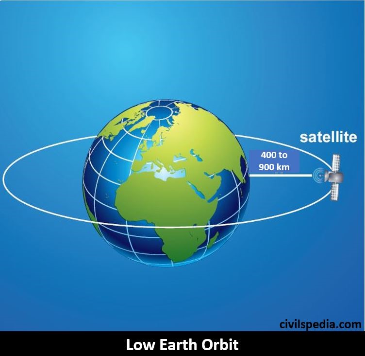
1. Low Earth Orbit (LEO)
- It is situated 400 to 900 km above the surface of the Earth.
- As it is situated closest to Earth, satellites have to overcome massive drag due to the atmosphere. Hence, satellites located in Low Earth Orbit have a shorter life span of 2-3 years.
- They appear to be moving in the sky & take approx. 1.5 hours for one revolution.
- The maximum time LEO satellites are visible from a fixed point on Earth is 20 minutes.
- Following are placed in LEO
- Astronomical Telescopes (eg : India’s Astrosat)
- Space Stations (eg : International Space Station (ISS))
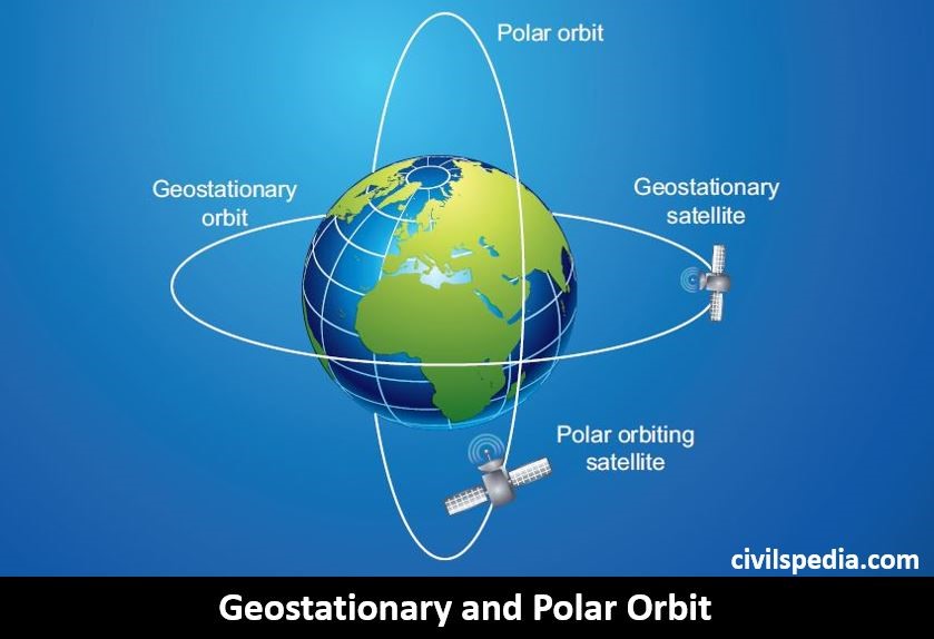
2. Geostationary Orbit
- There is only one Geostationary Orbit at 36,000 km above the earth surface above the equator.
- Satellites placed in the Geostationary Orbit revolves around the Earth with an orbital period of one sidereal day (23hours, 56 minutes, and 4.1 seconds).
- It is a circular orbit lying in the equatorial plane.
- It has a special property of remaining permanently fixed in the same position in the sky, meaning ground-based antennas do not need to track them but can remain fixed in one direction.
- Such satellites are often used for communication and broadcast purposes (due to the above property).
- Note: Single Geostationary Satellite can cover about 40% of the Earth’s surface. If three satellites are placed at proper longitude, the whole Earth can be covered. Arthur C Clarke first conceptualized this & the Geostationary orbit is sometimes referred to as Clarke’s Orbit in his honour.
3. Geosynchronous Orbit
- Geosynchronous Orbit is also situated at 36,000 km above the Earth’s surface, but it is non-circular & non-equatorial.
- Satellites placed in the Geosynchronous orbit also revolve around the Earth in one sidereal day, but they don’t appear to be stationary from Earth.
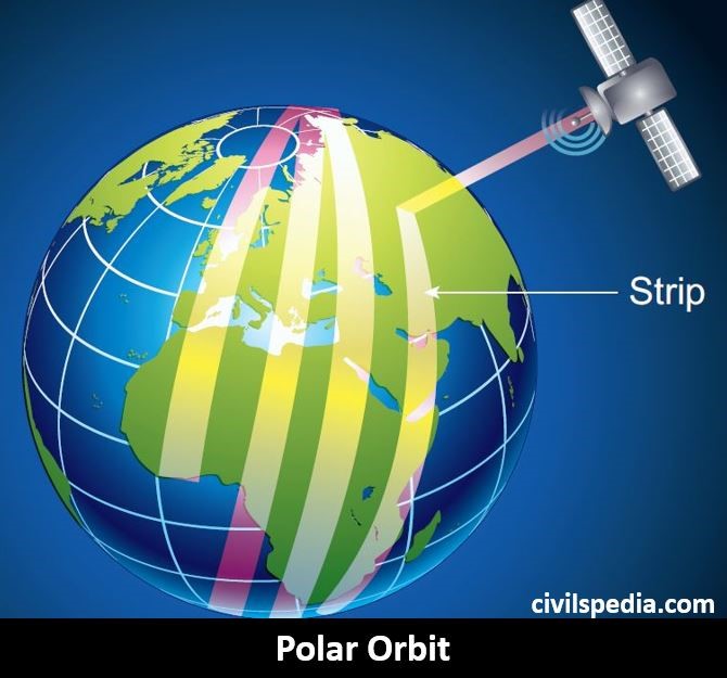
4. Polar Orbit
- Polar Satellites pass above both poles of Earth, i.e. they are inclined at 90 degrees from the equator.
- They are used for earth mapping, earth observation, surveillance & weather.
How it is used for mapping?
The time period of a polar satellite is nearly 100 minutes, and the Satellite completes many revolutions in a day. A Polar satellite covers a small strip of the area from pole to pole during one revolution. The next revolution covers a different area strip since the Earth would have moved by a small angle. In this way, polar satellites cover the entire surface area of the Earth.
5. Sun Synchronous Orbit
- It is a special type of Polar Orbit.
- In this, altitude & inclination are set in such a way that it guarantees the same illumination.
- It has the same application as polar satellites.
6. Junk Orbit / Graveyard Orbit
- When the life of Geo-Stationary Satellite completes, they are sent above Geostationary Orbit known as Junk Orbit
- It is an excellent way to tackle space junk.
7. Halo Orbit
- It is a specific type of solar orbit located at three Lagrange points (L1, L2 and L3) between Earth and the Sun.
- Lagrange point is a point in the space where the combined gravitational force of two bodies is equal to the centrifugal force felt by a third body.
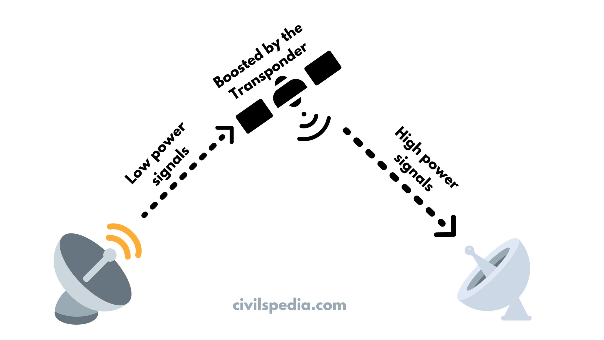
Transponders
- Transponders are part of the payload of satellites.
- Since the radio waves have to transverse long distances, the satellite receives the carrier signals at very low power. Therefore, satellites need to significantly boost the power of these signals before re-transmission back to Earth, ensuring that they are detectable by an Earth-based receiver. Transponders perform this function.
Different Types of Transponders
| Transponder Band | Frequency Range | Application |
| L | 1 to 2 GHz | GPS |
| S | 2 to 4 GHz | Weather radar |
| C | 4 to 8 GHz | Communication |
| X | 8 to 12.5 GHz | Military (defence tracking, maritime and air traffic control) and Meteorological (weather monitoring) |
| Ku | 12.5 to 18 GHz | DTH, Internet and VSAT services. |
| K | 18 to 26.5 GHz | BSS and FSS (Fixed Satellite Service) |
| Ka | 26.5 to 40 GHz | High resolution and close range targeting radars |
Satellite Systems
Remote Sensing Satellites
- Remote Sensing is the acquiring of information from a distance. Satellites that are used for such purposes are called Remote Sensing Satellites.
- These satellites are
- Placed in Polar Orbits.
- Sun-Synchronous (so that illuminance of the point is the same)
- Revolves around the Earth in low earth orbit (900 Km)
- Spaceborne remote sensing is better than ground surveys and airborne sensing because it is
- Cheaper
- Speedier
- More Accurate
- Reliable
- Multidimensional
- IRS-1A, launched in 1988, was India’s first remote sensing satellite. Present examples include Cartosat, Resourcesat, Scatsat, Oceansat, Saral etc.
Applications of Remote Sensing Satellites
1. Defence
- These satellites act as the ‘Spy in the Sky’ and are used for reconnaissance.
- They can easily pick up the troop movement and deployments by the enemy.
2. Agriculture
- Remote Sensing Satellites can be used to
- Assess net crop area.
- Movement of locust.
- Damage assessments.
- India is divided into 15 Agro-climatic zones based on data from IRS 1A and 1B.
- Pradhan Mantri Fasal Bima Yojana is also using the data of these satellites to estimate crop damages.
3. Disaster Management
- They are used for
- Early warning of cyclones, floods etc.
- Monitoring of forest fires.
4. Natural Resource Management
- Remote Sensing Satellites are used in
- Land use mapping
- Mineral prospecting
- Forest surveys
5. Urban Studies
- They are used in
- Mapping urban sprawl.
- Structural plans for cities.
6. Governance
- Geotagging of all the assets created under schemes like MNREGA, RKVY etc., can be done using these satellites.
7. Fisheries
- By analyzing the colour of the ocean, surface temperature and wind conditions from the oceans, it is possible to identify areas in the sea where the fish school will assemble.
Side Topic: BHUVAN
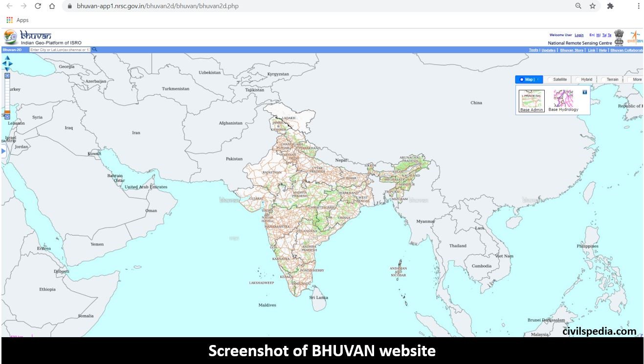
- BHUVAN is an application developed by ISRO using data provided by Indian Remote Sensing Satellites like Resourcesat, Cartosat-1 and Cartosat-2. National Remote Sensing Agency (NRSA) played an essential role in its creation.
- It provides medium to high-resolution imagery, with spatial resolution ranging from 10-100 metres, of entire India over the internet.
- The portal is designed to run even on slow internet. Images of Bhuvan includes weather information, administrative boundaries etc.
List of Remote Sensing Satellites
- Starting from IRS 1A, ISRO has launched many Remote Sensing Satellites, including HysIS, ScatSat, Cartosat etc.
- Initially, ISRO used to name its Remote Sensing Satellites as 1A, 1B etc. Later, it started to name these satellites based on the application of the satellites like CartoSat, OceanSat etc.
Important Indian Remote Sensing Satellites are as follows:-
1 . SARAL
- SARAL= Satellite with ARgos and ALtiKa.
- It is an Indo-French satellite.
- It was launched from Sriharikota, Andhra Pradesh.
- Application: meteorology, oceanography, climate monitoring etc.
2. Megha Tropiques
- It is an Indo-French Joint Venture.
- It was launched in 2011 using PSLV.
- Application: Study the tropical atmosphere and climate-related aspects such as monsoons, cyclones, etc.
3. NISAR
- NISAR = NASA-India Synthetic Aperture Radar
- Project was started in 2019. The satellite was completed in 2023 and has been sent to India to be launched from Satish Dhawan Launch Station.
- It is India’s first radar imaging satellite.
- NISAR is a combined mission of NASA (of USA) and ISRO (of India).
- Main features
- It is a dual-frequency (L and S-Band) Radar Imaging Satellite.
- NISAR is an Earth-monitoring satellite. NISAR will take images of the Earth every week. It is strong enough to take images of a tectonic plate and small changes in land use patterns.
- Landslides, volcanoes, drought, flood, etc., can be easily be observed through NISAR.
- Its application includes mapping and monitoring natural resources, assessing soil moisture, mangroves, surface deformation due to seismic activities, etc.
4. Spadex Mission
- Spadex Mission constitutes two satellites – SDX01 or Chaser and SDX02 or Target and acts as a technology demonstrator mission to demonstrate in-space docking.
- Docking is a process where two satellites are aligned and then joined in space. This technology is essential for India’s space ambitions, such as Indian astronauts on the Moon, sample return from the Moon, the building and operation of Bharatiya Antariksh Station (BAS), etc.
- The mission will constitute the following.
- Align in the same orbit
- Reduce distance between each other
- Join and transfer electrical power between them.
- Then separate.
- After they separate, payloads on both satellites will continue to function for two years.
- Satellites will be launched using a PSLV launch vehicle.
- India is the fourth country in the world to have space docking technology.
5. Cartosat Series
- Cartography is the science of drawing maps.
- Cartosat satellites: Cartosat series are earth observation satellites in a sun-synchronous orbit. They have high-resolution cameras installed on them. The imagery sent by Satellite is useful for cartographic (drawing maps) applications.
5.1 Cartosat-2
- Cartosat-2 was launched in 2017.
- In 104 satellite launches, this was the primary Satellite.
- It is primarily meant for military requirements (hence, it can be said that ISRO is moving from Civilian to Military uses too).
5.2 Cartosat 2s
- It was launched in 2018.
- It was launched using PSLV-40, which was India’s 100th launch, along with 30 other satellites.
5.3 Cartosat 3
- Cartosat 3 satellite has high-resolution imaging capability.
- Application: It is used for large scale urban planning, rural resource and infrastructure development, coastal land use and land cover along with Disaster Management Support Programs like Cyclone and Flood Mapping & Monitoring, Landslide Mapping & Monitoring, Agricultural Drought, Forest Fire, Earthquakes etc.
6. RISAT Series
RISAT (Radar Imaging Satellite) is series of Indian satellites providing all weather, day and night imaging.
6.1 RISAT 1
- Launched in 2012
- Provide high resolution images for agriculture, forestry, disaster management.
6.2 RISAT-2
- Launched in 2009
- Launched in aftermath of 2008 Mumbai attack, it was intended to provide border surveillance and deter terrorist infiltration
6.3 RISAT-2B
- Launched in 2019
- Provide earth observation intended to improve agriculture, forestry, and disaster management services.
6.4 RISAT-2BR1
- Launched in 2020
- Applications same as RISAT-2B
7. EOS-01
- EOS = Earth Observation Satellite .
- Launched in November 2020 in Polar Orbit using PSLV launch vehicle (PSLV-C49).
- Applications: Agriculture, forestry and disaster management.
8. EMISAT
- DRDO developed EMISAT under Project Kautilya.
- It is India’s first Electronic Intelligence Satellite.
- Application: EMISAT is meant for electromagnetic spectrum measurement and provides information to armed forces about hostile radars placed at the borders.
9. SCATSAT
- It is a weather satellite that mainly focuses on Cyclone formation.
- It has replaced the (earlier) Oceansat.
10. Oceansat Series
- Oceansat 1 (1999) , Oceansat 2 (2009) and Oceansat 3 (2022) have been launched till date. Latest, Oceansat 3 was launched in 2022.
- It is a sun-synchronous satellite.
- Oceansat satellites are designed and developed for ocean studies.
11. Kalam Global Sat
- It is a global satellite for Disaster Risk Reduction.
- It was launched at UN World Conference on Disaster Risk Reduction held at Sendai in Japan in March 2015.
12. HySIS
- HySIS is India’s first Hyperspectral Imaging Satellite (HySIS).
- It was launched with PSLV in Polar Orbit.
- Hyperspectral Imaging Technology combines the power of digital imaging and spectroscopy. Hence, every pixel in the image contains much more detailed information about the scene than a standard colour camera. It is used for mineral prospecting, soil survey, coastal water studies etc.
Side Topic: Indian Data Relay Satellite System (IDRSS)
- ISRO plans to launch a set of satellites that will track, send and receive information from other Indian Satellites.
- IDRSS satellites will be of 2,000 kg class and will be launched using GSLV launcher to geostationary orbit around 36,000 km away.
- In the coming years, these satellites will be vital to ISRO, whose roadmap includes advanced LEO missions such as space docking, space station, and distant expeditions to the moon, Mars and Venus.
Geosynchronous Satellites
INSAT and GSAT are the backbones of Indian Geosynchronous Satellite systems.
- Ford Aerospace Corporation of USA built the INSAT series under contract.
- GSAT series is an indigenous system developed by ISRO to make India self-reliant in broadcasting services.
Applications
India is considered a leader in the application of space technology to solve problems on Earth.
1. Telecommunication
- Satellites are responsible for the communication revolution in India.
- Using satellites, remote and far-flung areas have been effectively connected.
2. Television
India uses geostationary satellites to provide DTH (Direct to Home) services all over the country.
3. Disaster Management & Meteorology
Satellites can be used to provide
- Warning mechanism for the cyclone.
- Short term weather forecasting.
- Impact assessment for droughts and floods.
- Geosynchronous satellites can also be used in satellite aided search & rescue.
4. Navigation
- All the navigation systems like GPS, GLONASS, NAVIC, Galileo etc., use geosynchronous and geostationary satellites.
Important Geosynchronous satellites of ISRO
Earlier, India used the INSAT series, but now the GSAT series is used. INSAT 1 and 2 series (except INSAT 2E) has expired, but many INSAT 3 and 4 series satellites are still functional.
1. INSAT-3
- INSAT-3A was launched in 2003 using the Arianne launch vehicle, followed by INSAT-3B and 3C.
- INSAT-3 satellites have C and Ku band transponders and were meant for communication purposes.
2. INSAT-4
- INSAT-4A was launched in 2005 using the Arianne launch vehicle, followed by INSAT-4B.
- These satellites are used for telecast purposes. E.g., INSAT-4A is used by TATA Sky and INSAT-4B is used by Sun Direct and DD Direct.
3. CMS-01
- CMS-01 is the communication satellite launched by ISRO in December 2020.
- It has replaced GSAT-12, which was launched by India in 2011 and was India’s primary communication satellite.
- It will provide telecommunication services to mainland India as well as Andaman-Nicobar and Lakshadweep Islands.
4. Kalpana 1
- It was launched in 2002 using PSLV (weighing around 1060 kg).
- It is India’s exclusive meteorological Satellite and was initially named MetSat.
5. GSAT-7
GSAT 7 series satellites are advanced satellites developed by ISRO to meet the communication needs of the defence services. The satellites of GSAT 7 series include
- GSAT 7 satellite (launched in 2013) is mainly used by the Indian Navy for its communication needs.
- GSAT 7A (launched in 2018) helps in boosting the connectivity between the ground radar stations, airbases and the airborne early warning and control aircraft (AEW&C) of the IAF (Indian Air Force).
- GSAT 7B (to be launched shortly) will primarily fulfil the communication needs of the Army and enhance surveillance in border areas.
6. SAARC or South-Asian Satellite / GSAT-9
- PM Narendra Modi announced it at the SAARC Summit of 2014, and it was launched in 2017 using a GSLV launch vehicle.
- It points to India’s having started to use space diplomacy to strengthen the “neighbours first policy”.
- It is a communication satellite with Ku band transponders. South Asian countries, namely Bangladesh, Sri Lanka, Bhutan, Nepal, Maldives and Afghanistan, will get at least 1 Ku transponder each. It will provide the nations with capability in teleeducation, telemedicine, broadcasting, Direct-to-Home services (DTH) and VSAT capacity.
- It was the first Indian Satellite to use Electric Propulsion.
- India has borne all the other costs for the launch of the satellite.
7. GSAT-11
- It was launched in Dec 2018.
- It is the ISRO’s heaviest Satellite (5855 kg).
- GSAT-11 is aimed at providing broadband internet from space to untouched areas.
8. GSAT – 29
- It was launched in 2017 with Indian Launcher GSLV Mk – III with operational Cryogenic Stage from Sriharikota (first Satellite to be launched with GSLV MK III – Earlier all GSATs were launched with the help of French Agency Ariane Aerospace.)
- Application: Drive India’s Broadband Internet from space to the untouched areas by providing the throughput data rate of 16 Gbps.
Some Satellites of other countries
1. Amazonia 1
- Amazonia-1 is a Brazilian satellite launched by ISRO using PSLV (C51).
- It is a sun-synchronous remote sensing satellite that will be preliminary used for monitoring deforestation in the Amazon forests.
2. Laser Communication Relay Demonstration (LCRD) Satellite
- NASA has launched the LCRD, the first Satellite to use a laser communication system. Till now, radio communication has been used to transmit data via satellites.
- It is advantageous because it uses optical communication, which uses a shorter wavelength can transmit more data in a shorter time. Moreover, optical communication systems are lighter and are cheaper to launch.
3. Ravana 1
- The Sri-Lankan satellite was launched with Japanese (JAXA) help.
4. Ibuki 2
- Japanese satellite to observe Greenhouse Gases.
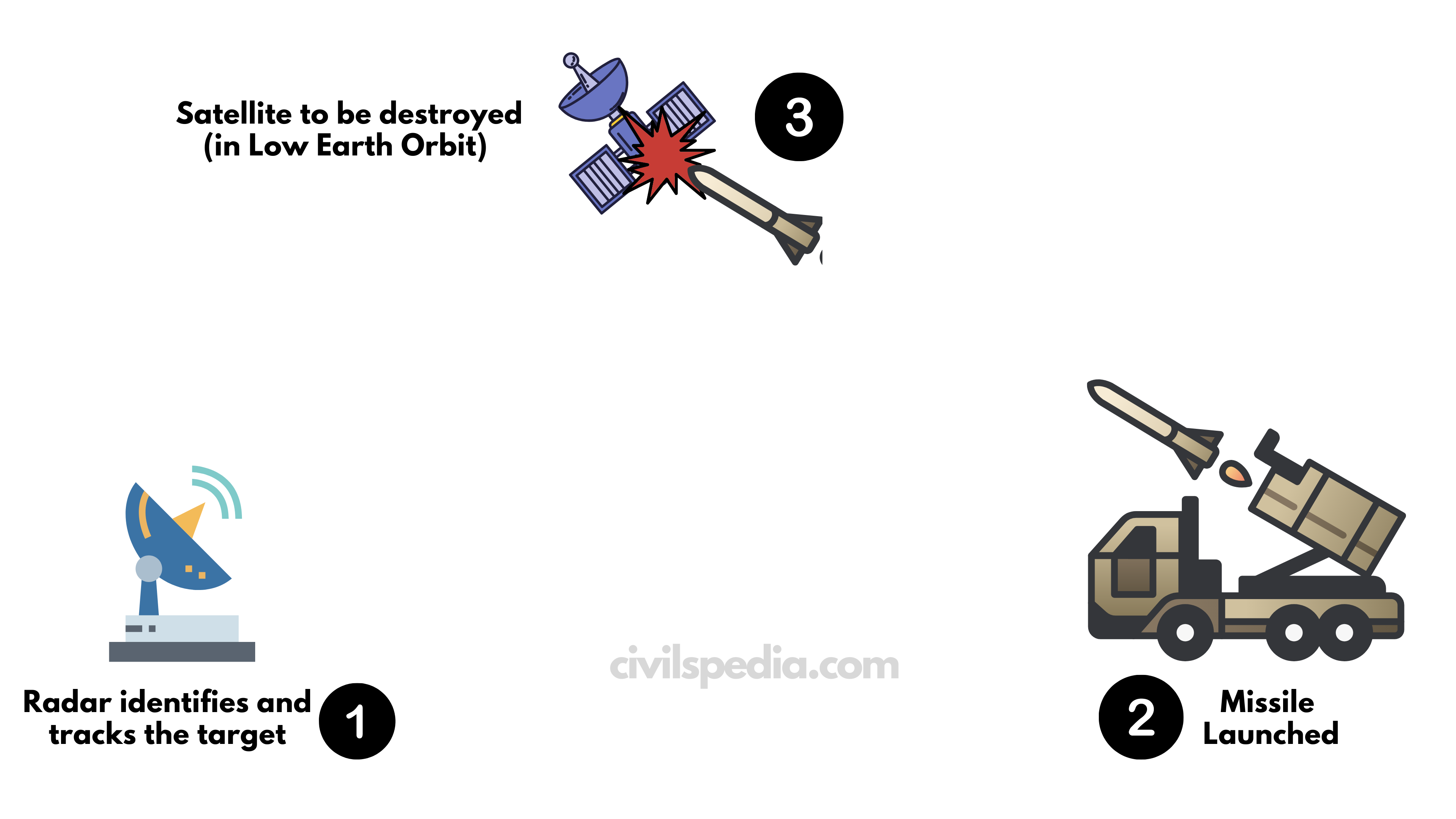
Mission Shakti – Anti Satellite Missile
What is Mission Shakti?
- Mission Shakti is an Anti-Satellite Missile.
- It is made by DRDO (not ISRO).
- It is the modified version of the Ballistic Interceptor Missile.
- It can detect, target & destroy space objects.
- To show it’s working, an obsolete (Indian) satellite at 300 km was tracked with sensors and destroyed.
- Note: Outer Space Treaty prohibits placing any weapon in earth orbit or on the celestial body. But none of the treaties is against such tests.
Importance
- It has made India a Space Power as India is the 4th country after the US (1958), Russia (1964) & China (2007) to have this capability.
- It will create a ‘credible deterrence‘ against attacks on India’s growing space assets (especially China).
- It will help India to avoid any chance of repeating the experience of what happened in the nuclear domain. If NPT-like mechanisms come in the space domain, India will be on the safer side.
Against
- It has created huge space debris. Earlier, 2007 Chinese tests produced 2000 space debris. NASA criticized India for the creation of Space Debris.
- It will lead to Arms Race in Asia. Pakistan will get an excuse to get this technology from China to claim parity.