Last Updated: June 2023 (Brahmaputra River System)
Brahmaputra River System
This article deals with the ‘Brahmaputra River System (UPSC notes)’. This is part of our series on ‘Geography’, which is an important pillar of the GS-1 syllabus. For more articles, you can click here.
Information at Glance
| Origin | Kailash Range of Tibet |
| Length | 2900 km (total) |
| Other names | 1. Yarlung Tsangpo (Tibetan name) 2. Dihang (in Arunachal Pradesh) 3. Brahmaputra (in Assam) 4. Jamuna (in Bangladesh) |
| Catchment Area | – Total: 12 lakh km2 – India: 3.21 lakh km2 |
| Tributaries | Left Side Tributaries: Dibang, Lohit, Dhansiri, Kelong, Kapili , Dikhu Right Side Tributaries: Kameng, Manas, Raidak, Subansiri , Teesta |
Flow of Brahmaputra
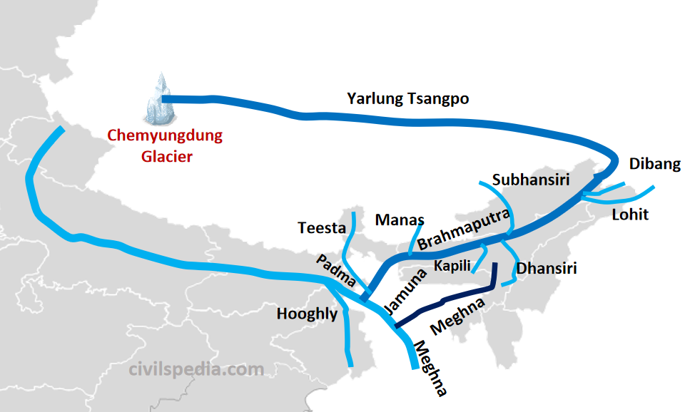
Flow in Tibet
- Brahmaputra River originates in Chemyungdung Glacier in the Kailash Range of Tibet.
- It traverses eastward longitudinally for 1,200 km in southern Tibet (known as Yarlung Tsangpo in Tibet). In Tibet, it receives water from tributaries (like Raga Tsangpo, Ngangchu, Kyichu etc.)
Flow in India
- After flowing for 1800 km eastward, Brahmaputra suddenly turns and emerges as a turbulent river after carving out a deep gorge (Dihang Gorge) in the Central Himalayas near Namcha Barwa. Here the river is known as Dihang or Siang. The river enters India in the west of Sadiya Town of Arunachal Pradesh.
- From Sadiya in Arunachal Pradesh to Dhubri in Assam, the river is navigable, and the Government of India has designated it as National Waterway 2.
- Here also, a large number of tributaries join the Brahmaputra. These include
| Right Bank Tributaries | Kameng, Manas, Raidak, Subansiri , Teesta |
| Left Bank Tributaries | Dibang, Lohit, Dhansiri, Kelong, Kapili , Dikhu |
- Note: Before the terrible floods of 1787, the Teesta was a tributary of the Ganga; however, it changed its path to join the Brahmaputra by heading east.
- Most of the Brahmaputra’s passage through Assam has a braided course. The river keeps on shifting its channel constantly. It forms many islands, the most important of which is Majauli (the largest river island in Asia, having 144 villages on it)
- Due to concentrated rainfall during the monsoon months, the river has to carry enormous amounts of water and silt, resulting in disastrous floods in the rainy season. Hence, it is also called a ‘River of Sorrow.’
Flow in Bangladesh
- At Dhubri, the river takes a southward turn and enters Bangladesh.
- It flows for 270 km under the name Jamuna and joins the Ganga. The united stream is known as Padma.
- Later, Meghna joins Padma on the left bank (Meghna originated in the mountainous region of Assam). The united stream of Padma and Meghna is known as Meghna, which forms a broad estuary before entering the Bay of Bengal.
Teesta River
- Origin: Kangse Glacier, Sikkim
- Teesta River enters Bangladesh after passing through West Bengal & meets Brahmaputra before entering the Bay of Bengal.
- It is the fourth largest river in Bangladesh after Brahmaputra, Ganga & Meghna.
- India & Bangladesh have a Water Dispute over sharing of the Teesta waters. After various rounds of dialogue, no consensus has been reached. It is the major source of irritant between Indo-Bangla Relations, which otherwise is a valuable ally of India.
Side Topic: Barak River
- Barak River rises in Manipur, then passes through Mizoram & Assam.
- The famous city of Silchar (Assam) is situated on it. After Silchar, it flows for about 30-odd kilometres & near Badarpur, it divides itself into the Surma and Kushiyara rivers and enters Bangladesh. Surma River then merges with the Meghna River.
- It is declared as National Waterway-6 by Govt. of India.
- India has also proposed the Tipaimukh Dam, which has become a source of conflict between India and Bangladesh.