Table of Contents
The Cycle of Seasons in India
This article deals with ‘The Cycle of Seasons in India.’ This is part of our series on ‘Geography’, which is an important pillar of the GS-1 syllabus. For more articles, you can click here
Introduction
India has four seasons as mentioned below.

Winter Season
- Winter season commences in January and remains till the end of February.
- During this period, due to the sun’s apparent movement towards the south, vertical rays of the sun fall over the Southern Hemisphere. That is why the temperature starts to decrease in the Northern Hemisphere, and pressure belts along with Inter Tropical Convergence Zone (ITCZ) start to move southwards.
- As the temperature over Indian Subcontinent starts to decrease in winter, the pressure starts to increase. The high pressure replaces the low pressure over Northern India.
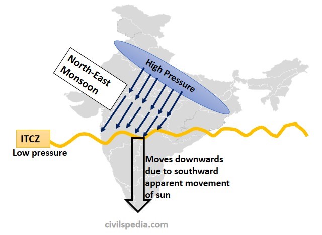
- The Inter-Tropical Convergence Zone (ITCZ) starts to move southwards and gradually moves out of India. As a result, monsoon winds also start to retreat, moving towards ITCZ, i.e. from North-West to South-East. These winds are dry as they move from land towards the sea and have already shed moisture. These are known as retreating monsoon or North East Monsoon.
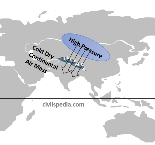
Cold Waves
- During this period, high-pressure areas develop over central and western Asia. Dry and cold continental winds from the Caspian Sea and Turkmenistan enter the Northern Plains, which cause a fall of many degrees in the temperature of the great plains. These north-western cold winds, moving at a speed of 3 to 5 km per hour, are termed as the Cold Waves.
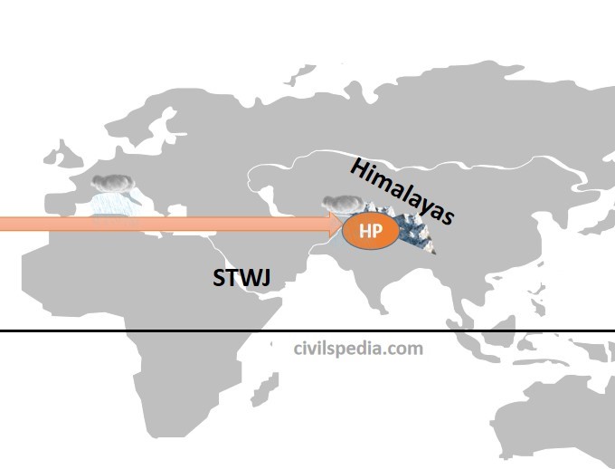
Jet Stream and Upper Air Circulation
- Along with that, Sub-Tropical Westerly Jet (STWJ), flowing over Tibet Plateau in the summers, shifts southwards and creates high pressure over North India. STWJ extends from the Mediterranean sea to Western Asia, the Persian Gulf, Iran and Pakistan, crosses the great plains of India and reaches the China sea.
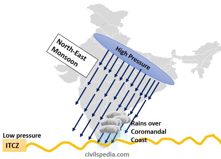
Rainfall due to North East Monsoon over Coromandal Coast in Winter
- Rain occurs in winter due to the North-East monsoon as well.
- When Inter-Tropical Convergence Zone (ITCZ) moves out of India, dry continental winds start to blow from North East to South-West.
- But a part of North-East winds pass over the Bay of Bengal & cause rainfall on the Coromandal Coast. It is known as North-East Monsoon and precipitates over Coromandal Coast only.
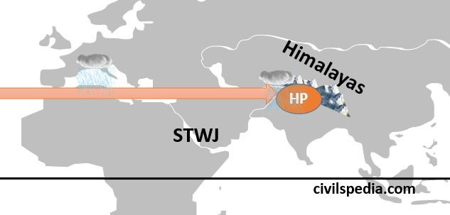
Western Disturbances
- Sub-Tropical Westerly Jet reaches Northern India after passing over the Mediterranean Sea, where it rains during winter. These winds bring cyclonic disturbances formed over the Mediterranean Sea to north India.
- Due to Sub-Tropical Westerly Jet,
- Punjab, Haryana, northern Rajasthan, Jammu and Kashmir and Western Uttar Pradesh receive an average of 20 to 50 cm of cyclonic rainfall, which is very useful for the Rabi crops.
- Neighbouring Himachal Pradesh, Kashmir and Kumaon Hills experience snowfall.
- Precipitation during the winter season is good for Rabi crops, especially wheat.
- But excessive rainfall can also cause crop damage, landslides and avalanches.
Weather in Cold Season
- The weather is pleasant in winter.
- Days are pleasantly warm (moderate)
- Nights are cold.
- Skies are clear with dry weather.
- Temperature decreases from south to north. It falls from 31° C in Trivandrum, 26° C in Calicut, 24° C in Chennai, 16° C in Varanasi, and Drass Valley has a temperature of -45° C
- Due to the sharp fall in night temperature, sometimes dense or heavy fog appears.
- Due to the cold waves in the plains, a severe frost occurs.
Summer Season
- At the end of February, the temperature rises as sun-rays fall vertically over areas north of the equator. Hence, the summer season remains from March till the end of May, and it is the longest season in India.
- Interior areas record the maximum daily temperatures. E.g., The maximum daily temperature recorded is
- 38° C in Nagpur
- 40° C in Madhya Pradesh
- 45° C in the North-Western parts
- 48° C in the Barmer (Rajasthan)
- But coastal lands have moderate climates due to moderating effect of ocean and sea breeze. The temperature remains between 30 to 32° C in South India.
Pressure Systems
- With an increase in temperature, Inter-Tropical Convergence Zone (ITCZ) starts shifting towards the north.
- In May and June, due to high temperatures, a low-pressure Thermal Depression develops in the north–western parts of the country. Additionally, the Sub-Tropical ‘Jet’ stream shifts towards the north of the Himalayas. In this way, a special situation develops in the north–west, in which till the height of 6–7 Km from the surface of the land, the low-pressure cycles join each other and attract the monsoon winds fastly towards themselves.
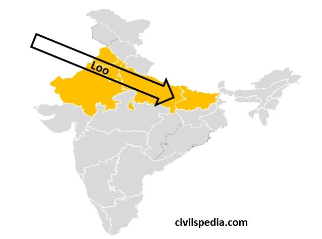
Loo
In summer, North India comes under the influence of Loo. Loo is a strong, dusty, hot, and dry summer wind blowing from the west over the western Indo-Gangetic plains region of Northern India. It is especially strong in May and June. Due to its very high temperatures, exposure to it leads to fatal heat strokes. Due to its high temperature and dryness, it has severe drying effects on vegetation leading to browning in the areas it affects.
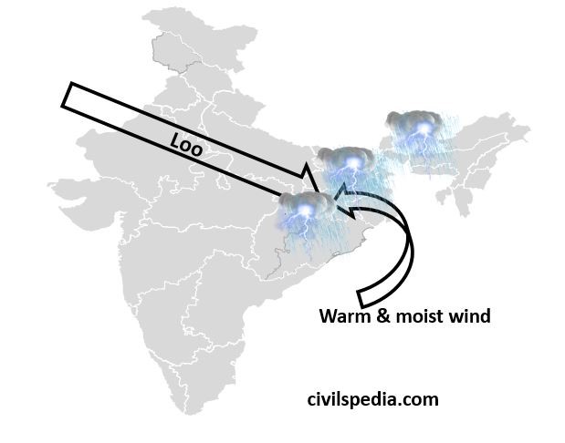
Norwesters or Kalbaisakhi
- The Loo ends in late summer due to the arrival of the monsoon. Loo (dry winds at high temperature) from the North-West and warm & moist winds from the Bay of Bengal converge around the Chotanagpur plateau. It causes thunderstorms and lightning accompanied by strong winds and heavy rainfall, mainly in the states of Assam and West Bengal.
- These local winds are known as ‘Norwesters’ or ‘Kalbaisakhi,’ i.e. calamity of the month of Baisakh. They bring rainfall in Assam, West Bengal and Odisha. This rainfall is quite beneficial for the cultivation of Jute and Rice in West Bengal and Tea in Assam.
Blossom and Mango Showers
- The coastal areas of Kerala and Karnataka receive rainfall close to the end of summer. These showers are extremely useful in the cultivation of tea, coffee and mango. They are also known as Mango Showers in Kerala (as they help in the early ripening of mangoes) and ‘Blossom Showers‘ in Karnataka, as with these showers, coffee flowers blossom in these areas.
Monsoon Season
Due to the rapid temperature increase in May over the north-western plains, the low-pressure conditions further are intensified. By early June, low pressure is powerful enough to attract the monsoon winds from the Indian Ocean. (we have discussed this already in the previous article)
The rain in this season begins abruptly. This sudden onset of monsoon with violent thunder and lightning is called the “burst” or “break” of the monsoons. The monsoon burst can happen in the first week of June in coastal Kerala, Karnataka, Goa and Maharashtra, while it may be delayed to the first week of July in interior parts.
With the onset of monsoon winds, the weather conditions change in the whole country. Its chief characteristics are
- High heat
- High humidity
- Extensive clouding
- Several spells of heavy to moderate rain with strong surface winds
Side Topic: Long Period Average (LPA)
- LPA is the average annual rain received by the country during the South-West monsoon (June to September) for 50 years.
- For 50 years ranging from 1960 to 2010 (used by IMA presently), India’s LPA is 88 cm (approx.)
| Deficient | If rainfall is less than 90% of LPA. |
| Below Normal | If rainfall is between 90-96% of LPA |
| Near Normal | If rainfall is between 96 to 104% of LPA |
| Above Normal | If rainfall is between 104% to 110% of LPA |
| Excess | If rainfall is above 110% of LPA |
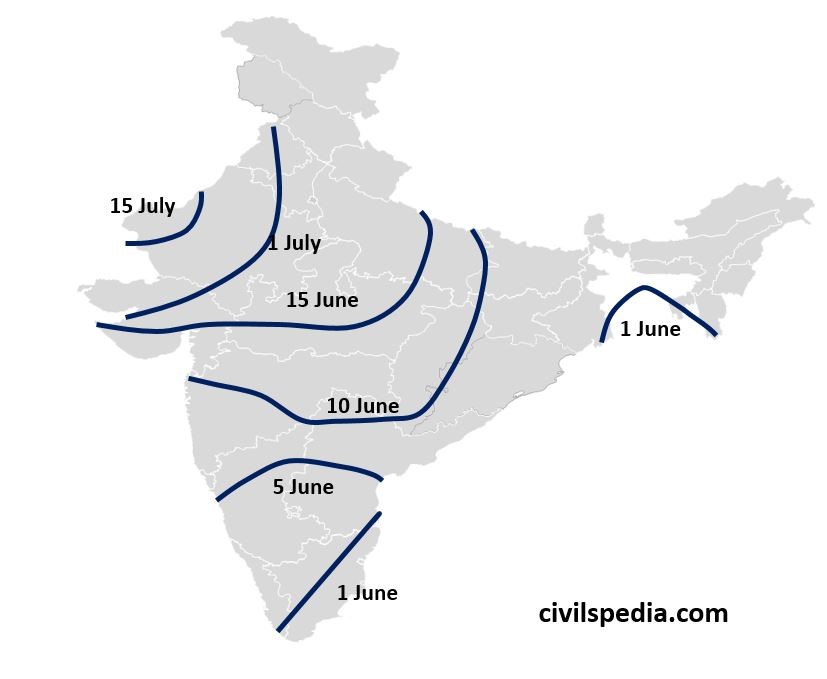
March of Monsoon Winds in India
When moisture-laden winds reach the southernmost tip of the Indian Peninsula, it divides into two parts due to its topography. These branches are the Arabian Sea Branch and the Bay of Bengal Branch.
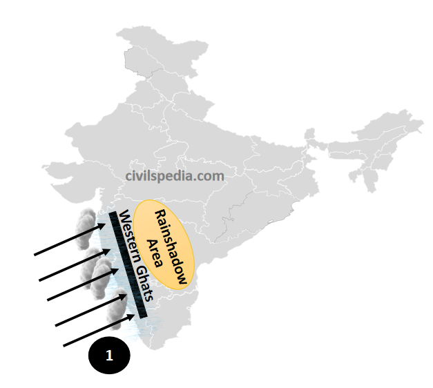
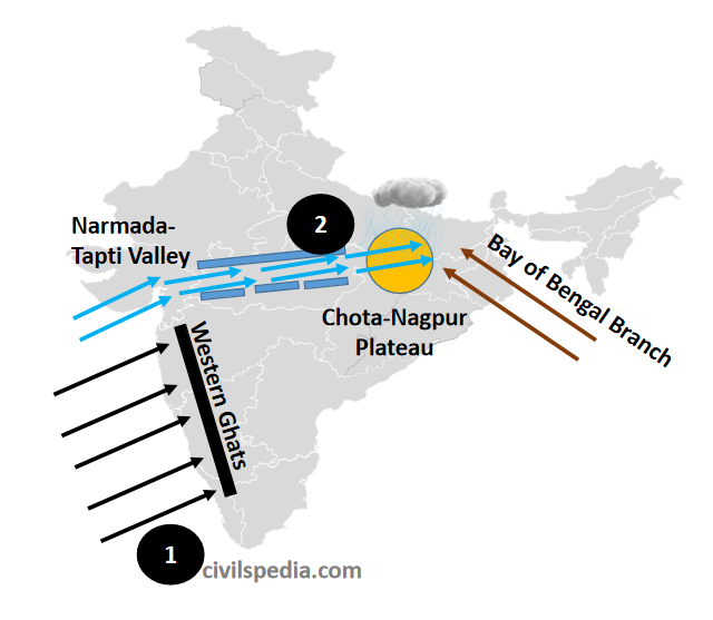
1. Arabian Sea Branch
- First of all, it encounters the Western Ghats. Full of moisture, when this branch tries to cross the 2000 metres-high Western Ghats, it gets cooled at the ‘lapse rate’ and starts raining. But it rains only on the windward side, i.e. western slopes of Western Ghats, while the leeward side, i.e. South Karnataka Plateau, Rayalaseema, Vidarbha etc., receives very scanty rainfall. Also, the amount of rainfall decreases as the moisture decreases while moving north of the Arabian Sea. For example, Mangalore receives 330 cm. of rainfall, and Mumbai receives 100 cm.
- The second sub-branch of the Arabian Sea moves through the valleys of Narmada and Tapi and reaches the Chota-Nagpur Plateau, where it joins the Monsoon winds coming from the Bay of Bengal and causes more than 150 cm of rainfall.
- Third sub-branch of the monsoon winds of the Arabian sea moves towards the north, through Gujarat and Sind delta. It causes very less rainfall over Kutch, Saurashtra and Thar Desert due to the following reasons.
- By this time, the moisture content is largely decreased
- Aravalli range is parallel to these winds, and these just move straight, without rising high, along these mountains.
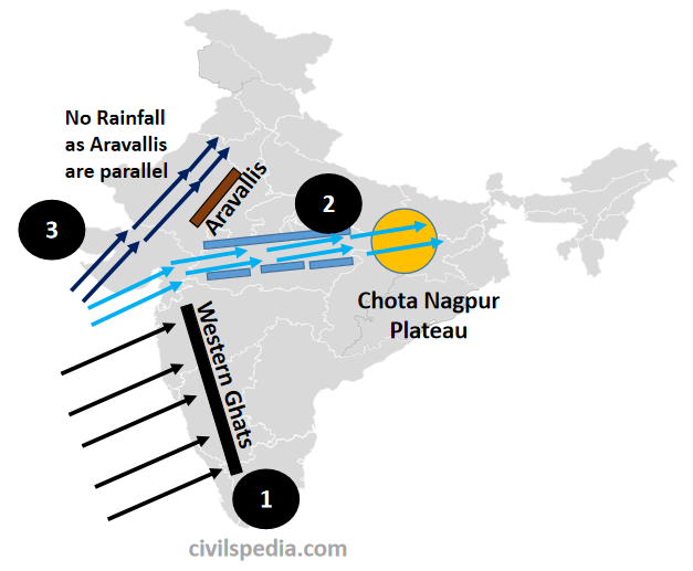
- On reaching Punjab, Haryana and Himachal Pradesh, these monsoon winds join the Bay of Bengal monsoon branch and bring rainfall to these regions.
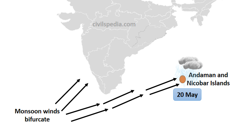
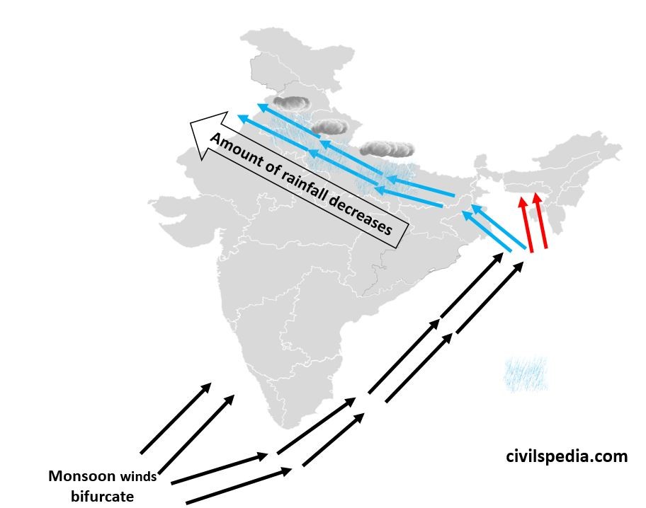
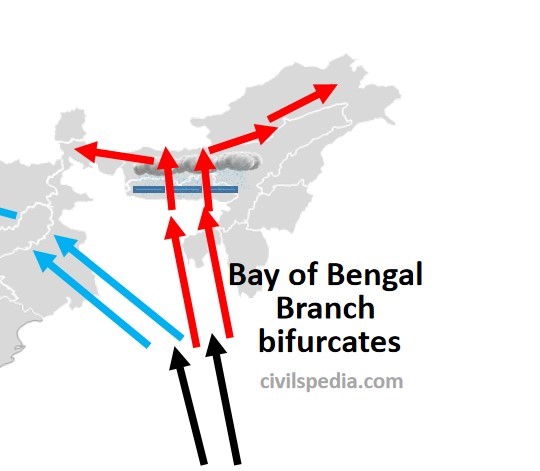
2. Bay of Bengal Branch
- First of all, Monsoon winds hit Andaman and Nicobar Island on 20 May (MCQ = first of all, it hit A&N . Hit Western Ghats and North East on 1 June)
- Bay of Bengal Branch is then directed towards Myanmar and South-East Bangladesh. However, owing to the presence of Arakan Yoma hills along the coast of Myanmar, a large part of the Bay of Bengal Branch is deflected towards the Indian subcontinent. The monsoons, therefore, enter West Bengal and Bangladesh from the South and South-East.
- The Bay of Bengal branch then bifurcates into two branches. One branch moves along the Ganga Plain, pouring rain on the Northern plains. It rains very heavily in West Bengal. But by the time monsoon winds reach Punjab and Haryana, they become dry resulting in lesser rainfall over these regions. The rainfall decreases from East to West, i.e. Kolkata receives 120 cm, Patna receives 102 cm, Allahabad receives 91 cm, Delhi receives 56 cm, Ludhiana receives 40 cm, and Amritsar receives 25 cm from the Bay of Bengal branch.
- The second sub-branch of the Bay of Bengal Branch moves towards the Brahmaputra valley. First, it strikes the Garo, Khasi and Jaintia hills of Meghalaya. While crossing the 1500 m high hills, these saturated winds bring heavy rainfall. Chirapunji and Mawsynram, which are situated in the southern part of Khasi hills, receive the highest average rainfall in the world. Then these winds move towards Assam and Arunachal Pradesh and cause rainfall in Guwahati, Darjeeling etc.
Note: Tamil Nadu Coast doesn’t receive any rainfall from the Bay of Bengal branch because the Tamil Nadu Coast is situated parallel to the direction of the Bay of Bengal Branch and in the rain-shadow area of the Arabian Sea branch.
Depressions in the South West Monsoon
An Easterly Jet Stream flows in the Upper Troposphere of the southern part of Peninsular India in June. It is confined to 15 N in August and 22 N in September. This Easterly Jet Stream usually does not extend north of 30 N.
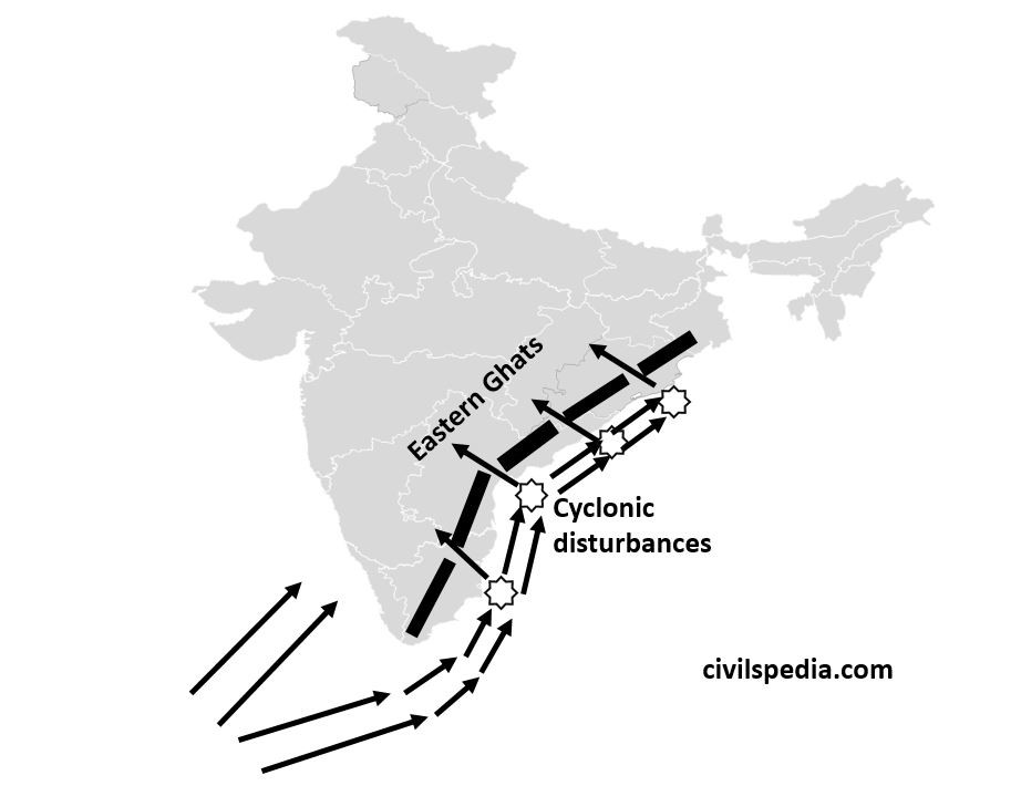
ITCZ while passing over the Bay of Bengal, cause the formation of Tropical cyclones in the Bay of Bengal. These Tropical cyclones are then steered inwards through the gaps in the Eastern Ghats (made by the eastern flowing rivers) by the Tropical Easterly Jet Streams and cause cyclonic rainfall.
Dates when South West Monsoon hits various regions
Characteristics of the Indian Monsoon
Some of the unique features of the Indian monsoon are
- Sudden onset: start of the monsoon is very abrupt.
- Gradual advance: once started, it advances very slowly & gradually
- Gradual retreat: monsoon winds go back slowly
- Seasonal in Character: Rainfall received from the southwest monsoon is seasonal in character and occurs only between June & September.
- Largely governed by topography: Monsoon rains are governed by the region’s topography. E.g., Western ghats receive massive rainfall, and Aravallis receive almost none (explained above).
- Monsoon has ‘breaks,’ i.e., wet spells of few days interspersed by rainless days.
- Monsoon has Variations: These variations are both regional & temporal.
Variation in Monsoon
We will cover both Temporal and Spatial Variation when asked about variations.
1. Temporal Variations
The distribution of rainfall varies temporally during the four seasons.
- Winter Season
- In winter, there is little rainfall in regions of India.
- The reason for the winter rainfall in North-West India is Western Disturbances.
- Summer Season
- In Summer, torrential local rains happen when there is a sudden contact between dry and moist air masses.
- South-West Monsoon season
- The four wet months of June through September account for more than 80% of the annual precipitation.
- In the coastal regions, the monsoon begins in the first week of June; however, it may not begin until the first week of July in the nation’s interior parts.
- Rainfall from monsoons is mostly influenced by relief or topography, and it tends to decrease as one gets farther from the sea.
- Retreating Monsoon
- In response to the sun’s southward march, the monsoon begins to weaken around the end of September.
- India’s north experiences dry weather, whereas the Coromandal Coast experiences rain.
2. Spatial Variations
- Areas of High Rainfall (Over 200cm): Maximum rainfall occurs along mountain ranges that block moist winds, such as the west coast, as well as in sub-Himalayan regions in the northeast, such as the Garo, Khasi, and Jaintia hills.
- Areas of medium Rainfall (100-200 cm): Medium rainfall happens in the north-eastern Peninsula covering Orissa, Jharkhand, Bihar and eastern Madhya Pradesh, east Tamil Nadu, southern parts of Gujarat, and northern Ganga plain.
- Areas of low Rainfall (50-100 cm): Most regions showing continentality, like Jammu and Kashmir, Punjab, Haryana, eastern Rajasthan, Western Uttar Pradesh, Delhi, Deccan Plateau and Gujarat.
- Areas of inadequate Rainfall (Less than 50 cm): In Ladakh, western Rajasthan and the Interior Peninsula (Andhra Pradesh, Karnataka and Maharashtra)
4. North East Monsoon /Retreating Monsoon
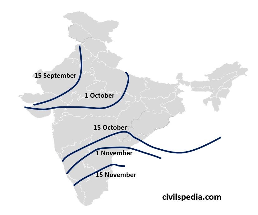
- Rain happening in October and November is known as Retreating Monsoons.
- The Inter-Tropical Convergence Zone begins moving southward in response to the sun’s southward movement towards the end of September, which weakens the southwest monsoon. Hence, the temperature in the Northern Plains starts decreasing, and consequently, pressure starts increasing. In response to this, Monsoon winds start to retreat from northern India, and this is also known as North-East monsoon as the winds blow from North-East to South-West.
- These monsoon winds retreat in almost the same sequence as they arrive in the country.
- They first leave Punjab till 15 September,
- Uttar Pradesh till 1 October,
- Ganges Delta till 15 October
- Till 15 November, these leave southern parts of Karnataka and Andhra Pradesh.
- The retreat of the monsoon is marked by clear skies and a drop in the night temperature. But the land still remains moist. The combination of high temperature and humidity gives rise to oppressive weather and is known as ‘October Heat.’
- The North-East monsoons are generally dry as they originate on land except on the coastal areas of Tamil Nadu, i.e. Coromandal coast because when they pass over the Bay of Bengal, they collect moisture and shed that moisture on the Tamil Nadu coast.

Cyclones on the Eastern Coast during retreating monsoon
- Due to the shifting of ITCZ over the Bay of Bengal and the convergence of winds on both sides of ITCZ, cyclonic depressions are created in the Bay of Bengal, whose water is already at high temperature due to continuous heating throughout the summers. These cyclones move towards the west or north-west.
- These cyclones frequently hit the eastern coastal region and cause significant damage to life and property. The areas most vulnerable to these storms include the coastal belt of Tamil Nadu, Andhra, Odisha and West Bengal.
- The number of devastating severe Cyclones hitting the Indian coasts has been increasing owing to the increase in sea surface temperature in the northern Indian Ocean.