This article deals with ‘Satyendra Nath Bose – UPSC.’ This is part of our series on ‘Science and Technology’ which is an important pillar of the GS-3 syllabus. For more articles, you can click here.
Introduction
Satyendra Nath Bose was an Indian physicist renowned for developing the theory of Bose-Einstein statistics and the concept of the Bose-Einstein condensate.
He hailed from the Nadia district in West Bengal and pursued his education at Presidency College, Kolkata.
Contribution 1: Bose-Einstein Statistics
It describes how a collection of non-interacting and indistinguishable particles distribute themselves among a set of available discrete energy states, at thermodynamic equilibrium.
Bose sent his findings to Albert Einstein. The statistics was extended to gas molecules by Einstein, and particles that obey the B–E statistics principle are referred to as “Bosons”(named after S. N Bose). Bosons are fundamental articles that have integer values of spin (0, 1, 2, etc.). E.g. Photon, Gluon, etc.
Contribution 2: Bose-Einstein Condensates (BEC)
At extremely low temperatures (near 0 Kelvin or -273.15 Celsius), a large fraction of bosons can occupy the same lowest-energy quantum state and become indistinguishable from each other, forming a unique state of matter (e.g., superfluid helium or ultra-cold atomic gases). BEC is referred to as the ‘fifth state of matter.’
Properties of BEC include:
Superfluidity: Bose-Einstein Condensates (BEC) have zero viscosity and can flow without resistance.
Superconductivity: Bose-Einstein Condensates (BEC) have zero resistance, leading to optimal conductivity.
Coherence: All particles in the BEC are in the same quantum state, behaving as a single entity.
Bose-Einstein Condensates has important complications and usage in areas of
Quantum Computing
Superconductivity
Precision Measurements
Sensing Technologies
Atom Lasers
Side Topic: God Particle
The Higgs Boson, also known as the God Particle, was discovered using scientific principles rooted in Bose-Einstein statistics and the concept of BEC.
This article deals with ‘Space Junk‘. This is part of our series on ‘Science and Technology, which is an important pillar of the GS-3 syllabus. For more articles, you can click here.
Introduction
Space Junk is the collection of defunct objects in orbit around Earth.
Two primary debris fields exist, i.e. (1) the ring of objects in the Geostationary Orbit and (2) the cloud of objects in the Low Earth Orbit (LEO).
Kessler’s Syndrome
Matter in the orbit travels at ridiculously high speeds. If this matter were to travel in the same plane and direction indefinitely, it would be impossible for any matter to collide. However, in space, uncontrolled objects do not follow a straight path. Instead, each piece of debris is subject to drift and decay and can collide with each other at any time.
The chance of collision is influenced by the number of objects in space. Beyond a certain point, a runaway chain reaction may occur that would rapidly increase the number of debris objects in orbit and significantly increase the risk to operational satellites. This is known as Kessler’s Syndrome.
Risks associated with Space Debris
Kessler Syndrome (explained above)
Increased cost of space launches due to extra protective and mitigation measures.
Interference with astronomical observations.
Risk to space assets and astronauts
Large space debris re-entering the atmosphere in an uncontrolled way can create a risk to the population on the ground.
Steps to Combat Space Junk
Steps by India
Project NETRA (Network for Space Object Tracking and Analysis): It is a joint project of ISRO and the Indian Institute of Astrophysics (IIA). Under the project, optical telescope facilities, connected radars, data processing units, and a control centre will be established to track space objects as small as 10 cm up to an orbit of 2,000 km.
Debris-Free Space Missions (DFSM) 2030: It aims to achieve debris-free space missions by all Indian space actors by 2030.
Space Situational Awareness Control Centre (SSACC): It assimilates tracking data of inactive satellites
International Level
Inter-Agency Debris Coordination Committee (IADC): It is an international governmental forum for worldwide coordination related to man-made and natural debris in space.
Zero Debris Charter: Signed by 12 countries, it contains high-level guiding principles and jointly defined targets to become debris-neutral by 2030.
This article deals with ‘Dr. Hargobind Khorana – UPSC.’ This is part of our series on ‘Science and Technology’ which is an important pillar of the GS-3 syllabus. For more articles, you can click here.
Initial Life
Dr Hargobind Khorana was born in Raipur village of Multan district (Punjab) in 1922. He later became a naturalized citizen of the US.
His early training was in chemistry, but later, he started applying chemistry to solve problems in biology, beginning the field of Chemical Biology.
Major Achievements
Interpretation of the Genetic Code
He received the 1968 Nobel Prize for Physiology or Medicine (shared with Nirenberg and Holley) for interpreting genetic codeand its function in protein synthesis.
Synthetic DNA
Dr Khorana constructed the world’s first synthetic gene, paving the way for further advancements in the field of genetic engineering and biotechnology.
Exploration of DNA Polymerase
DNA Polymerase are enzymes that help in replicating DNA. He contributed to the science of Polymerase Chain Reaction (PCR) tests, used to detect genetic material from a specific organism, like a virus.
Discovery of tRNA
Dr. Khorana discovered the structure of transfer-RNA, or tRNA (small RNA molecule that participates in protein synthesis).
Vision Studies
He had an interest in investigating the molecular process behind vision.
He investigated rhodopsin mutations associated with retinitis pigmentosa, which causes night blindness. Rhodopsin is a light-sensitive protein found in the retina of the vertebrate eye.
This article deals with ‘Parliamentary System– Indian Polity.’ This is part of our series on ‘Polity’ which is important pillar of GS-2 syllabus . For more articles , you can click here.
Introduction
In India, there
is a Parliamentary form of
government at the State and Centre levels.
Centre
Article 74 and
Article 75 speak about it.
State
Article 163 and
Article 164 speak about it.
Definition of Parliamentary System
Government in which the Executive is responsible to the Legislature for its policies is known as Parliamentary System of Government.
It is also known as
Cabinet
System
Responsible Government
Westminster Model of
Government
Features of the Parliamentary System
The President
is the nominal (de jure) head, while the Prime Minister is the real (de
facto) Executive.
The Party, which secures a
majority of seats in Lok Sabha, forms the government.
Ministers are collectively
responsible to
Parliament (i.e. they swim and sink together).
Usually, members of the
Council of Ministers belong to the same Political party and hence share
the same ideology.
There is a double membership.
Ministers are members of the Executive and legislature.
The Prime Minister plays a
leadership role, and he is the leader of the council.
President can dissolve the
lower House on the recommendation of the Prime Minister.
Merits of the Parliamentary System
Harmony
between the Legislature and Executive as members of Executive are members of the
Legislature, too.
Government is
responsible as
it is answerable to Parliament for acts of omission and commission.
Prevents
despotism as Executive is
controlled by various tools like No Confidence Motion, Zero Hour Discussion
etc.
There is ready
alternate government if no-confidence motion is passed against the ruling
party.
It provides broad
representation as the Executive consists of a variety of members
Demerits of the Parliamentary System
The
government is unstable and stands at the mercy of Legislators.
There is no continuity of
policies. When government changes, policies also change, which is bad for
the economy.
The government can become
autocratic if the ruling party enjoys an absolute majority.
It is against the
Principle of Separation of Power.
It is not conducive to
administrative efficiency as ministers are not experts in their
fields.
Why did India Choose the Parliamentary System?
Historical Continuity: Familiarity with the system due to its presence in
British India.
Emphasis on Responsibility: Preference was given to the system that
prioritizes responsibility over stability.
Recognition
of the need to avoid the Legislative-Executive divide, which was necessary for an
immature democracy like that of India
Fear of an Overly Strong Executive: Constituent Assembly feared
too strong Executive
Representation in a Diverse Society: In a diverse society like
India, this system provides representation to more diverse groups in the
Executive
Avoidance of Personality Cult: The alternative to the Parliamentary Executive
was a Presidential form of government. However, the Presidential
Executive puts much emphasis on the President. There is always danger
of a personality cult.
Indian System is different from British System
India Parliamentary System
BritishParliamentary System
Republican system
Monarchial system
Parliament is not supreme and
enjoys limited and
restricted powers due to the
written constitution, judicial review and fundamental rights
It is based on the Doctrine of
Sovereignty of Parliament
PM can
be a member of any of the two houses
PM
should be a member of the Lower house
Non-MP
can be appointed as a Minister, but he has to
acquire
membership within 6 months
MP alone
can be appointed as Minister
There is
no legal responsibility of the Minister
The
legal responsibility of the Minister is present
There is no Shadow Cabinet
Shadow Cabinet is present
Features of the (American) Presidential System
The President in the American
Presidential System holds a dual role as both the head of state and head
of government.
President is elected by the
electoral college for 4 years and can be removed by impeachment.
President governs with help of
his secretaries who are not elected and are answerable to him only.
Advice of secretaries not
binding on the President
The President and his
secretaries are neither answerable to the Congress nor have any
membership.
The American Presidential
System operates on the fundamental principle of the separation of powers
in which the executive, legislature & judiciary are independent &
separate.
Should India switch over to Presidential System?
Question of changing
over to Presidential System has been raised various times
1956
Nehru himself
expressed his doubts about whether the Parliamentary System could meet the
needs of the times and the complexities of modern administration.
1960s
The desirability of
a switch-over to the Presidential system was discussed & several eminent
men, including a person like JRD Tata, advocated a Presidential system for
India.
1967
After Nehru, Congress’s monopoly of power began to
be eroded at the level of States. The Presidential model is
described as a remedy for all of India’s ills.
Indira’s Reign
Demand became the
most prominent
Arguments against
This issue was
sufficiently discussed in the Constituent Assembly, and it made an informed
choice after
considering both the British and American models.
It would violate the ‘basic
structure‘ of the
Constitution.
Presidential system centralises
power in one individual unlike the Parliamentary System, where Prime
Minister is first among equals.
A diverse
country like India can only function with consensus-building. But the Presidential System
works on a “winner takes it all” approach.
‘Outside’ talent can be
brought into a parliamentary system, too. Examples: C.D. Deshmukh, T.A.
Pai, Manmohan Singh etc.
Arguments in flavor
There is no
genuine separation of powers as the legislature cannot truly hold the executive
accountable since the government wields the majority in the House.
During the time of the coalition
government, the government is unstable and stands at the mercy of MPs &
MLAs
Cabinet posts would not be
limited to those who are electable rather than able. Experts can
become ministers/secretaries.
Fear that an elected President
could become a Caesar/Authoritarian is ill-founded since the President’s
power would be balanced by the legislature (including Rajya Sabha)
It is good for diverse country
like India because to get Bills passed, President instead of facing a
monolithic opposition, would have the opportunity to build
issue-based coalitions on different issues.
The Parliamentary system
was taken from Britain, but conditions similar to Britain do
not exist in India. It
requires the existence of clearly defined political parties, whereas, in
India, a party is all too often a label of convenience.
The Present Parliamentary System has been tried and tested for nearly 70 years. As a famous saying goes – Why fix a thing which isn’t broken? Rather than changing the system, we should reform thoroughly and cleanse the electoral processes.
This article deals with ‘Mother & Child Health – for UPSC.’ This is part of our series on ‘Society’, which is an important pillar of the GS-1 syllabus. For more articles, you can click here.
Why government should invest in Mother and Child Health?
Question: Imagine government as an investor. Given fiscal and capacity constraints, where would it invest to reap maximum benefits?
According
to the Economic Survey, low-cost maternal
and early-life health and nutrition programs offer very high returns because:
Spending on a mother is an economical option as a healthy mother is more likely to give birth to a healthy baby who learns better and stays in school longer. Additionally, a newborn’s most rapid physical and cognitive development occurs in the womb.
The success of subsequent interventions—schooling and training—is influenced by early-life development. E.g. Government’s investment in skills training can reap the best results only if Child has developed full Cognitive & Physical Health at an early age.
Important Indicators
Neo-Natal Mortality Rate
It is the number of deaths of children below the age of 1 month per 1000 live births.
According to NFHS-5 (2019-2021), India’s Neo Natal Mortality Rate is 24.9
NFHS-5 (2019-2021)
24.9
NFHS-4 (2015-2016)
29.5
Neo-Natal Mortality depends upon Mother’s health, as the leading cause of Mortality during the first month differs from the next 11 months. It depends on Utero Nutrition which is determined by the Birth-Weight of Children.
India has high Neo-Natal Mortality because Indian women begin pregnancy at low weight. Along with that, they don’t gain weight during pregnancy, resulting in low birth weight of the child.
Infant Mortality Rate (IMR)
Number of deaths of children below the age of 1 year per 1000 live births.
According to NFHS-5 (2019-2021), India’s Infant Mortality Rate is 35.2.
NFHS-5 (2019-2021)
35.2
NFHS-4 (2015-2016)
40.7
Note: IMR is an important indicator for determining the socio-economic status of any country because, more than any age group, the survival of infants depends upon their socio-economic environment.
Child Mortality Rate (CMR)
CMR is the number of deaths of children in the age group of 0-4 years per 1000 live births.
Under Five Mortality Rate (U5MR)
Number of deaths of children in the age group of 0-5 years per 1000 live births.
According to NFHS-5 (2019-2021), India’s U5MR is 41.9.
NFHS-5 (2019-2021)
41.9
NFHS-4 (2015-2016)
49.7
U5MR is an internationally accepted standard instead of Child Mortality Rate. Hence, India is moving towards it.
Maternal Mortality Rate (MMR)
The Maternal Mortality Rate is the death of mothers during or within 42 days of childbirth per 1 lakh live births.
According to NFHS-5 (2019-2021), India’s MMR is 97.
NFHS-5 (2019-2021)
97
NFHS-4 (2015-2016)
130
Schemes of Government to reduce MMR , IMR , CMR
Pradhan Mantri Suraksheet Matritva Yojana (SMY)
Launched by Health Ministry in 2016
It provides Ante-Natal (before birth) check-ups for pregnant women on the 9th of every month by specialist doctor
Janani Suraksha Yojana
Launched by Health Ministry in 2005
To promote Institutional delivery of pregnant women instead of home births, which can be risky
LaQshya Program
LaQshya, or Labour Room Quality Improvement Initiative, was launched in 2018 by Health Ministry.
The scheme aims to upgrade the Labour Room infrastructure, ensure essential supplies’ availability, and enhance healthcare providers’ skills.
Pradhan Mantri Matru Vandana Yojana
Launched by Health Ministry in 2017
Under the scheme, ₹5,000 is given to eligible mothers. The benefits are provided in the following manner:
First instalment: ₹1,000 is given upon early registration of pregnancy, usually within the first trimester (up to 180 days).
Second instalment: ₹2,000 is given upon receiving at least one antenatal check-up after six months of pregnancy.
Third instalment: ₹2,000 is given upon the birth of the child and registration of the child’s birth, along with the submission of the child’s immunization details.
It is applicable for first two children
Integrated Child Development Program
It is a flagship scheme which aims to improve the nutrition, health status & school dropout ratio of children in the age group 0-6 years.
In 2016-17, other schemes like Anganwadi Services and National Crèche Scheme were brought under this scheme.
To Combat Diseases among Pregnant Women & Infants
Anaemia: Major problem in Pregnant women. Iron Folic Acid Supplements are given by the government
Diarrhoea: A large number of infants die because of this. The government gives ORS and Zinc Tablets.
This article deals with ‘The Northern Mountains(Geomorphology of India).’ This is part of our series on ‘Geography’, which is an important pillar of the GS-1 syllabus. For more articles, you canclick here.
6 physiographic divisions of India
India
can be divided into 6 Physiographic features.
The Northern Mountains
The Great Northern Plains
The Peninsular plateau
The Indian Desert
The Coastal Plains
The Islands
The Northern Mountains
Himalayas extend ~2500 km in length, passing through 12 Indian states covering 17% of the Indian geographical area & consist of many valleys between them.
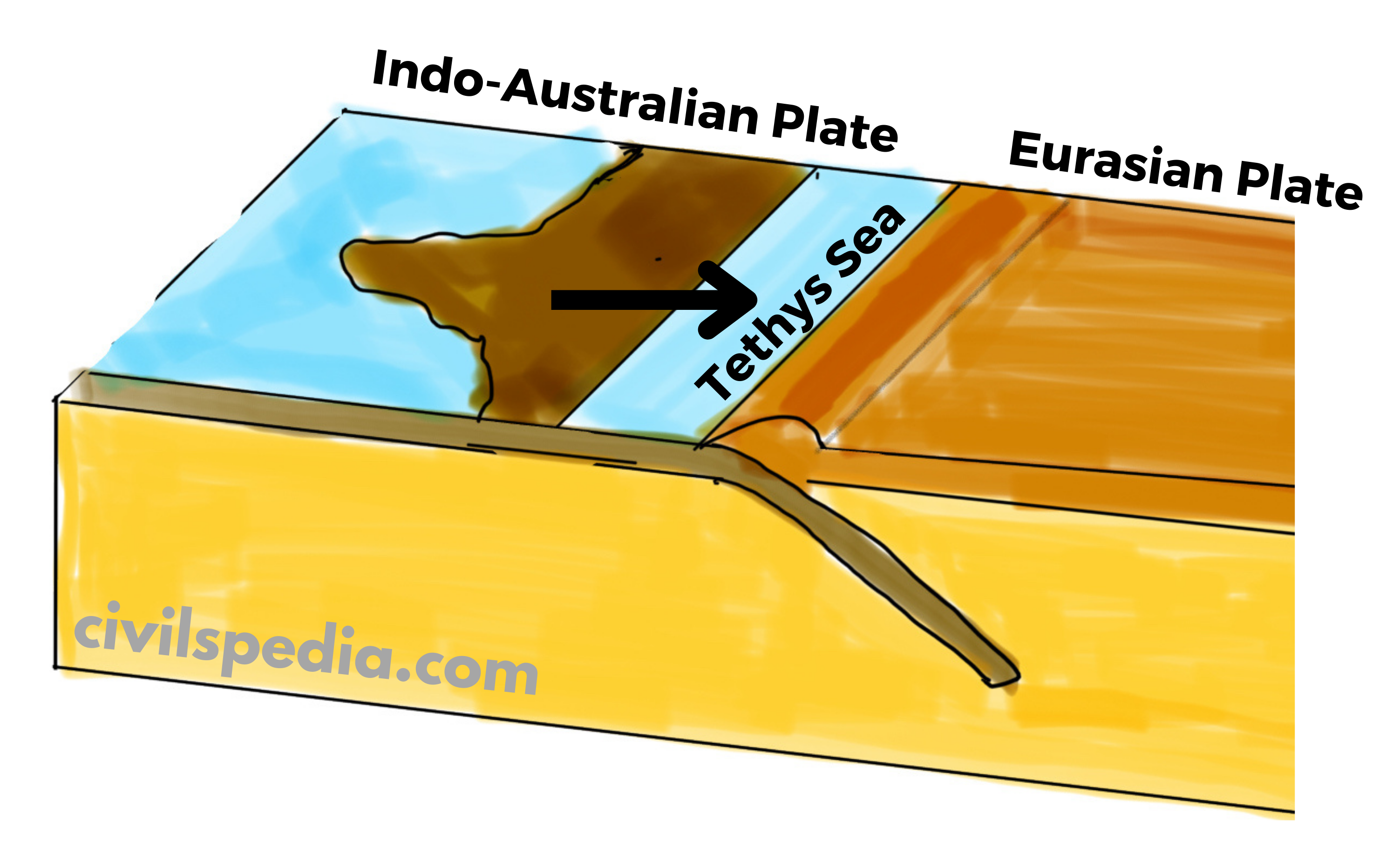
These mountains consist of the youngest and the loftiest mountain chains in the world because they were formed only a few million years ago due to the collision of the Indo-Australian and Eurasian plates.
The region is vast, rugged & versatile, supporting remarkable cultural, ethnic & biological diversity.
Formation of Himalayas
The Himalayas were formed due to the convergence of tectonic plates, i.e. Indo-Australian plate in the south and the Eurasian plate in the north.
The place where the Himalayas are situated today was occupied by the Tethys Sea. On its sea bed, sediments were deposited, brought by the then rivers from the Tibetan plateau in the north and Gondwana land (Deccan Plateau) in the south.
About 70 million years ago, the Indo-Australian plate separated from Gondwanaland and started to move towards the Eurasian plate at a speed of 12cm/year. As a result, Tethys Sea began to contract.
Since the Indian plate was made up of denser material than the Eurasian plate, the Indian plate started to subduct under the Eurasian plate causing the lateral compression and folding of sediments accumulated in the Tethys Sea. The Himalayas are thought to have formed as a result of the compression of sediments from the Tethys Sea over three distinct stages.
First Phase: Started about 50 million years ago and completed 30 million years ago with the formation of the Great Himalayas.
Second Phase: Took place between 30 to 25 million years ago, resulting in the formation of the Middle Himalayas.
Third Phase: Took place between 20 to 2 million years ago, resulting in the formation of Shivaliks.
The Indo-Australian plate is still moving northwards at 5 cm/year, and the Himalayas are still rising.
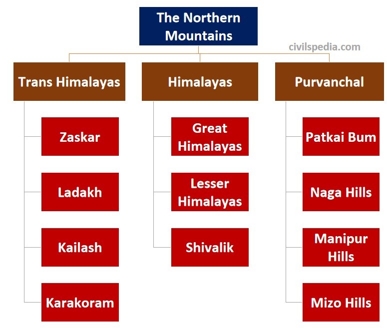
Divisions of Northern Mountains
The collision of the Indo-Australian plate with the Eurasian plate was not smooth. This collision led to the formation of a number of ranges. These ranges include Trans-Himalayas, Himalayas and Purvanchal. The Himalayas and other high peaks are joined by the Pamir Knot, also referred to as the “Roof of the Earth.”
In India, the Northern Mountains are grouped into three divisions. 1) The Trans-Himalayas, 2) the Himalayas, 3) the Eastern or Purvanchal Hills.
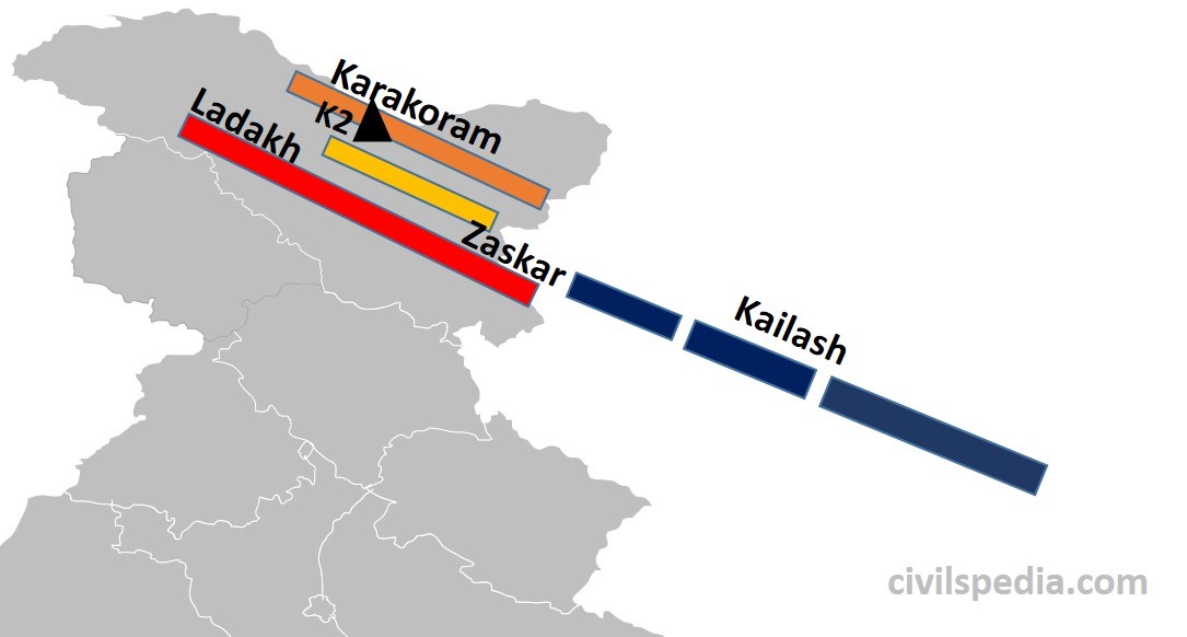
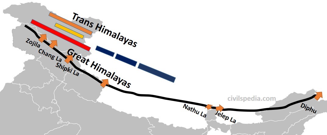
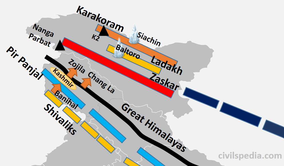
1.1 Trans Himalayas
It lies north of the great Himalayan range in Kashmir, Ladakh, and the Tibetan plateau.
They are of volcanic origin as they were formed by the volcanic eruption due to the initial interactions between the oceanic part of the Indo-Australian and Eurasian plates.
They also contain the Tethys sediments.
The prominent ranges of the Trans Himalayas are Karakoram, Ladakh, Zaskar and Kailash.
It has some of the highest peaks in the world, like K2 (the highest mountain peak in India and the second-highest peak in the world).
To the north of trans-Himalayas lies the heavily dissected, eroded, flat region known as the Tibet plateau. This region has numerous saline lakes like Salt Lake, Pangong Tso, Tso Moriri etc.
Karakoram-Ladakh region has India’s largest notified protected area (i.e. national park) known as Hemis National Park. It has the highest density of Snow Leopards in the world.
1.2 The Himalayas
The Himalayas are the core part of the northern mountains.
The Himalayas extend from the Indus Gorge in the west to Namcha Barwa (or Dihang Valley or Brahmaputra Gorge) in the east (~2500 km).
These are young fold mountains formed very recently in Earth’s geological history.
The shape of the Himalayas is like a convex curve towards our country, whose middle portion is sagged inwards India. Its reason lies in the process of its formation. When Indo-Australian Plate collided with Eurasian Plate, Aravalli and Shillong Plateaus were situated at the western and eastern edge of the colliding region where the Himalayas were formed. Hence, the western and eastern edge was strong, but the middle part was plain & therefore weak, which got sagged, resulting in the convex shape of the Himalayas.
The slope of these mountain ranges in the south towards India is very steep, whereas it has a gentle slope towards China in the north (due to the presence of the high Tibetan Plateau). That is why it is difficult to cross the Himalayas from the south.
Many Antecedent rivers reach plains after passing through the Himalayan mountains. Antecedent rivers are those that were present before the formation of the Himalayas, and their water source is beyond the Himalayas. Although their path was blocked due to the formation of the Himalayas, they gradually made their way after eroding the Himalayas. These include Indus, Sutlej, Brahmaputra etc.
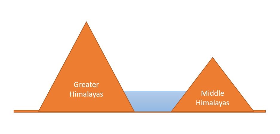
The main divisions of the Himalayas are
Greater Himalayas
Lesser Himalayas
Shivaliks
1.2.1 The Greater Himalayas
These are also known as Internal Himalaya or Himadri.
They are about 25 km wide.
The average height in this range is 6100 meters. Mount Everest (8,848 m), the highest peak in the world, is also situated in this range along with other high peaks like Kanchenjunga, Makalu, Dhaulagiri etc.
Due to their great heights, the peaks of almost all mountains remain snow-covered throughout the year. Since it is a region with permanent snow cover, it has many glaciers like Gangotri, Yamnotri, and Siachin.
It is the longest and most continuous sub-division of the Himalayas. Its length is 2400 km and extends from Nanga Parbat (or Indus Gorge) in north–west to Namcha Barwa (or Dihang Valley or Brahmaputra Gorge) in the east.
It contains sedimentary rocks (due to the folding of sediments of the Tethys Sea) as well as Metamorphic rocks (due to pressure created by the collision of two plates).
It contains many passes. Although, it is very difficult and dangerous to cross this mountainous subdivision. But still, many passes are found to cross this, like Burzil and Zojila in Kashmir, Chang La in Ladakh, Shipki La in Himachal Pradesh, Lipulekh in Uttarakhand, Nathula and Jelep La in Sikkim and Diphu pass in Arunachal Pradesh.
The Greater Himalayas receive less rainfall than the Lesser Himalayas and the Shivaliks.
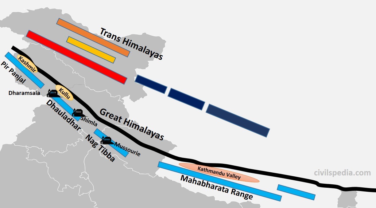
1.2.2 The Lesser Himalayas
They are also known as Himachal or Middle Himalayas.
The height of this range varies from 3,700 to 4,500 m.
Its width varies up to 80 km. (hence, it is lower in height but wider than Greater Himalayas)
Slate, limestone & quartzite are the major rocks found in this range.
This region is subjected to extensive erosion due to heavy rainfall, deforestation and urbanization.
It also contains famous hill stations of the Himalayas like Shimla, Mussourie, Nainital, Almora, Ranikhet and Darjeeling.
Lesser Himalayas are not a continuous range (unlike Greater Himalayas) and is divided into
Pirpanjal (J&K)
Dhauladhar (Himachal Pradesh)
Nag Tibba (Uttarakhand)- Mussourie & Kumaon ranges are part of Nag Tibba
Mahabharata Range (Nepal)
The region between Greater Himalayas and Lesser Himalayas contains many valleys like Kashmir Valley, Kangra Valley, Kullu Valley, Bhagirathi Valley and Mandakini Valley.
Many passes are also present, which provide passage through Lesser Himalayas to reach these valleys like Banihal and Qazigund, connecting Jammu with Kashmir.
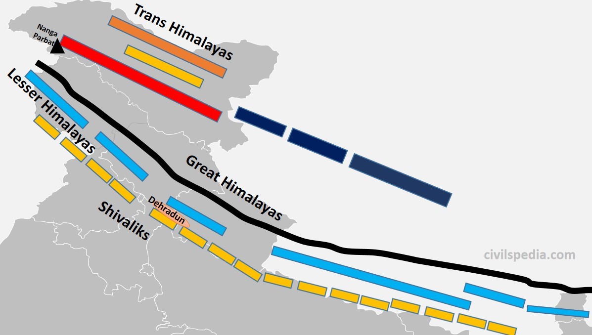
1.2.3 The Shivaliks
Also known as Outer Himalayas and Southern Himalayas
Siwaliks extend from Jammu and Kashmir to Assam.
Their average height varies between 900 to 1200 metres. Hence, they are the lowest among all Himalayas.
It is mainly made by the debris brought by the Himalayan rivers as they were geologically formed during the Tertiary period by the upliftment of the foothills of the Himalayas, where rivers have settled their sediments.
It is the most discontinuous range.
Longitudinal valleys are found between the Shivaliks and the Lesser Himalayas, which are called Duns. The most famous among these are Dehradun, Patlidun, Udhampur etc.
They are known by various names like
Jammu Hills (in J&K)
Dhang and Dundwa (in Uttaranchal)
Churia Ghat Hills (in Nepal)
Dafla, Miri, Abhor and Mishmi (in Arunachal)
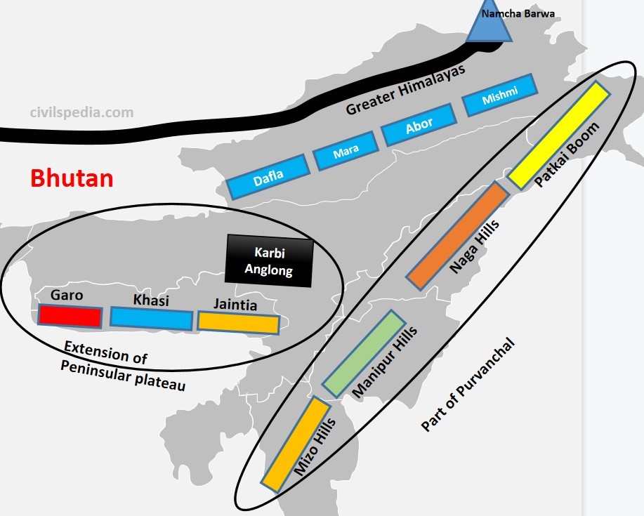
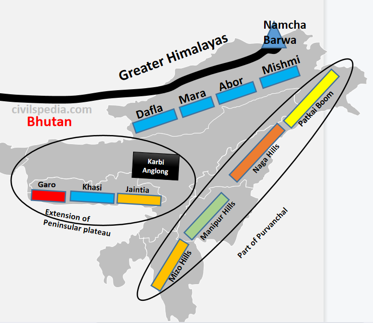
1.3 Purvanchal
After
crossing Dihang Gorge, the Himalayas bends southward (syntaxial bend), forming
a series of hills. They have the same progeny as that of the Himalayas &
are part of the Northern mountain system. They are aligned north to south and
are known by different local names.
Patkai Bum
Forms border between India and Myanmar
Naga Hills
Situated in Nagaland and forms the border between India and Myanmar
Manipur Hills
The physiography of Manipur is unique, represented by the presence of ‘Loktak’ lake in the centre and surrounded by mountains called Manipur Hills from all sides.
Mizo Hills
– They are also known as the Lusai Hills. – Mizoram is also known as the ‘Molasses Basin’as it is made up of soft unconsolidated deposits brought by small rivers originating in these hills.
Arakan Yoma
Purvanchal extends in Myanmar as Arakan Yoma, which further continues southwards as Andaman and Nicobar Islands.
Above ranges in the Purvanchal are separated from each other by numerous small rivers.
Note:
Garo, Khasi, and Jaintia hills of the Meghalaya plateau are not a part of
Purvanchal or the Himalayas in general. They are an extension of the Peninsular
Plateau.
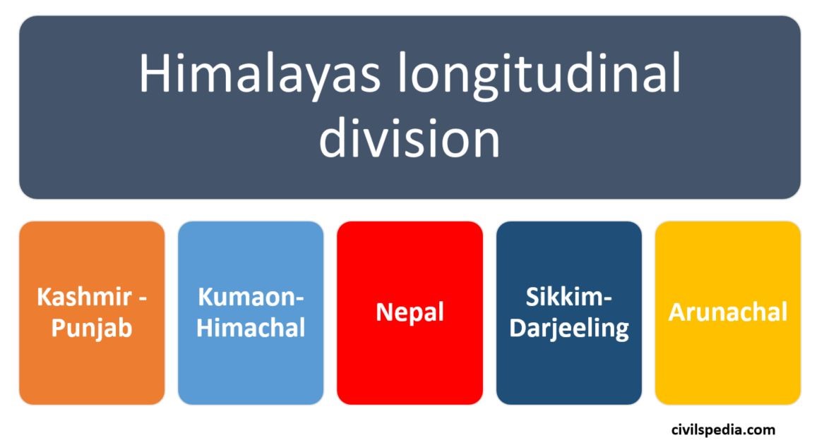
2. Longitudinal Divisions of Himalayas
There
is another way to divide the Himalayas longitudinally into Kashmir-Punjab
Himalayas, Kumaon Himalayas, Nepal Himalayas, Sikkim-Darjeeling Himalayas and
Assam Himalayas.
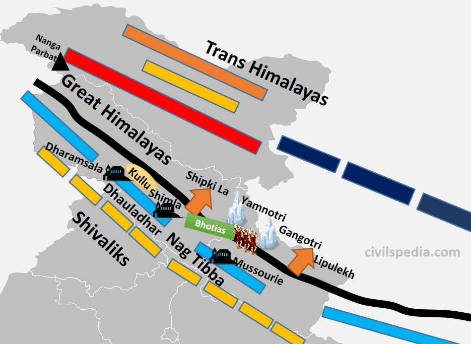
2.1 Kashmir-Punjab Himalayas
Major Characteristic of the Kashmir Himalayas is deep valleys, and high mountain passes like Zoji la, Bara Lacha La, Banihal and Qazigund.
Between Great Himalayas and the Pir Panjal range lies the world-famous valley of Kashmir
The Baltoro and Siachen glaciers, two significant glaciers in South Asia, can also be found here.
Kashmir Himalayas are famous for its Karewa formations, known for cultivating Zafran, a local variety of saffron.
Some of the important freshwater lakes like Dal & Wular and saltwater lakes like Pangong Tso & Tso Moriri are also in this region. ( Note: Dal Lake is Oxbow Lake).
Srinagar is located on the banks of the Jhelum River, and Dal Lake, situated in Srinagar, presents an interesting geographical feature. Jhelum River in Kashmir valley is still in its youth stage but forms a meander – a feature associated with the mature stage of rivers.
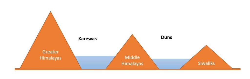
Side Topic: Karewas Formation
During the Quaternary period, when Pir Panjal Mountains were formed, the Kashmir valley, surrounded by Great Himalayan Range in the north & Pir Panjal Range in the south, was submerged under water, and a big lake of about 5000 sq km area was formed. All the sediments that rivers brought to this giant lake kept settling downwards.
Later, because of endogenic forces, Baramullah Gorge was created, and this vast lake was drained through the gorge leaving behind sediments. These deposits are called Karewas. Hence, Karewas are fluvio-lacustrine Plains
Examples of lacustrine plains include.
The Kashmir Valley of India.
The Imphal Basin in the Manipur hills
The watershed of the Red River in the USA and Canada
The Karewas are well suited for the cultivation of saffron, walnut, almond, and orchards.
Jhelum is still in its Youthful stage in Kashmir, but it forms Meanders, characteristic of the Mature Stage. Why?
Meanders are formed when moving water erodes the outer banks, whereas the inner part of the river, having less intensity, deposits silt and sediments, which results in a snake-like pattern of the water stream.
The main requirement for the Meander formation is the need for silt and sediments and the slow speed of river waters.
In Kashmir valley, these sediments are provided by local base levels of formerly existing Karewas.
It is the reason Jhelum meanders. Along with that, the formation of Wular Lake, which is an Oxbow lake, is also explained by this phenomenon.
Shivalik (locally called Dhang and Dundwa Range in Uttaranchal)
In Lesser/Middle Himalayas section of the Kumaon-Himachal Himalayas, the altitude between 1,000-2,000 m attracted the British colonial administration due to its moderate climate (resembling the British weather). Subsequently, important hill stations such as Dharamshala, Mussorie, Shimla, Kaosani etc., were developed in this region.
Dun formation is an important feature of this part. The largest of all the duns, Dehra Dun measures roughly 35–45 km in length and 22–25 km in width.
This section, too, has passes like Shipki La and Lipulekh pass. Lipulekh is used as a pathway to reach Kailash Mansarovar in Tibet.
In the Great Himalayan section of the Kumaon-Himachal Himalayas, the valleys are inhabited mainly by the Bhotias. The Bhotias is a nomadic tribe that moves to the higher ranges’ called “Bugyals” (summer grasslands) in the summer and return to the valleys in the winter.
Kumaon-Himachal Himalayas has many glaciers like Nandadevi, Badrinath, Kedarnath, Gangotri and Yamnotri, a source of rivers like Yamuna and Ganga. Many pilgrimages, such as the Gangotri, Yamnotri, Badrinath, Kedarnath and Hemkund Sahib, are also situated here.
Side Topic: Duns formation
Duns are the same as Karewas, i.e. they too are fluvio-lacustrine plains formed with sediments left behind by a former lake, with the only difference being that they are formed between Middle Himalayas and Siwaliks.
When Shivalik was formed, drainage of the region was impounded & the whole area was submerged in water between Shivalik & Middle Himalayas, creating a huge lake. The river gradually finds weak rocks to cut across mountains & flows through it. Lake dries up & duns are formed by the sediments left by the former lake.
E.g. Dehradun between Siwaliks and Mussoorie range, Jammu Dun between Pir Panjal and Shivaliks, Pathankot Dun between Siwaliks and Dhauladhar, Chandigarh-Kalka dun etc.
Some of the water remained in the depressions forming lakes known as Taals. Examples include Nainital, Bhimtal etc.
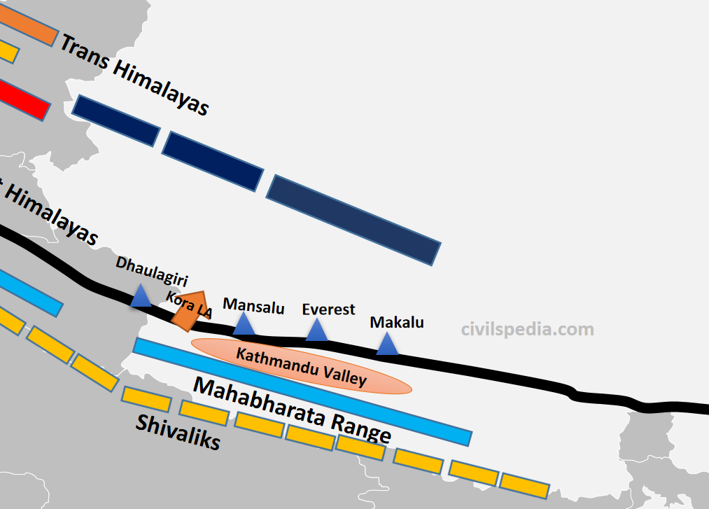
2.3 Nepal Himalayas
It is the tallest section of the Himalayas.
Mountain sections in it include
Great Himalayas containing peaks like Dhaulagiri, Annapurna, Mansalu, Everest, Makalu etc
Middle Himalayas: Mahabharata range
Shivaliks (locally called Churia Ghat Hills)
The famous and densely populated Kathmandu Valley is situated between Great Himalayas and Middle Himalayas.
Passes like Kora La connects Kathmandu valley with Tibet (will be used by China to build railways and roads and was in the news).
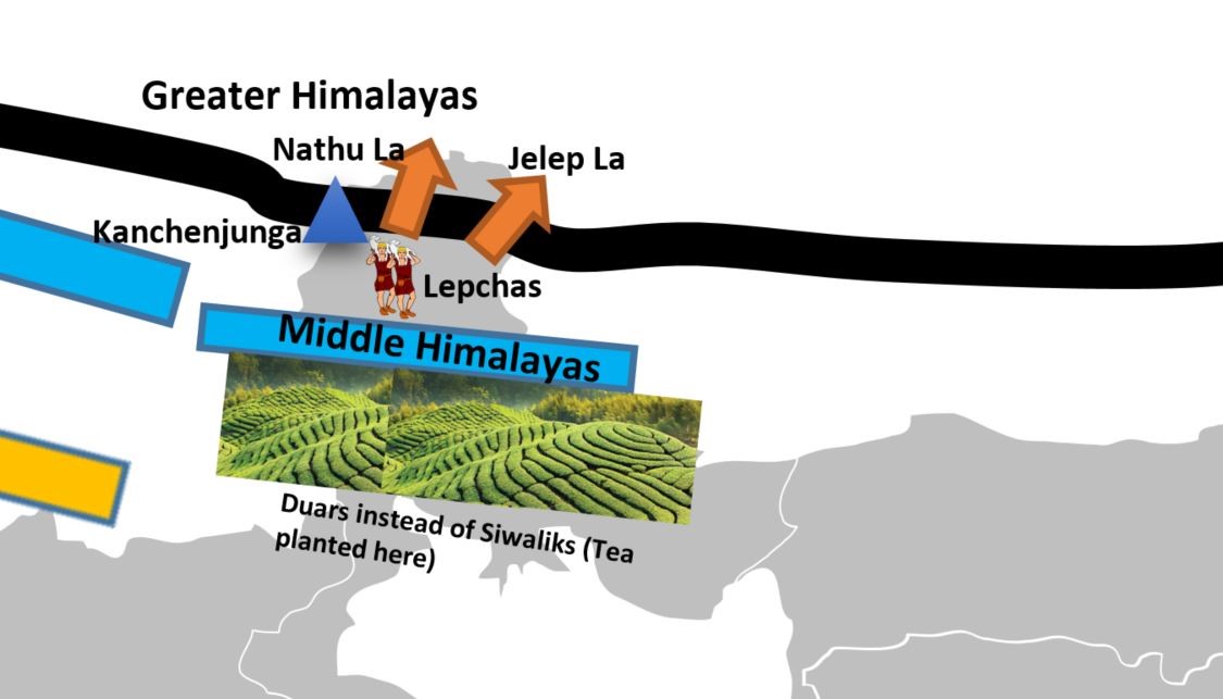
2.4 Sikkim/Darjeeling Himalayas
Sikkim Himalayas lies between Kosi & Teesta Rivers.
It is an area with deep valleys and lofty mountain peaks like Kanchenjunga (Kanchengiri).
Lepcha tribes inhabit the higher reaches of this region, while the southern part (Darjeeling) has a mixed population consisting of Bengalis, Nepalis and tribals from Central India.
The British established tea plantations in this area by taking advantage of the favourable physical circumstances, which included a moderate slope, thick soil cover with high organic content, evenly distributed rainfall throughout the year, and mild winters. They, together with the Arunachal Himalayas, stand out from the other Himalayan ranges due to the absence of the Shivalik formations. Here, the “duar formations” are significant—which have also been exploited to create tea gardens.
Sikkim & Darjeeling Himalayas are known for their scenic beauty & rich flora & fauna, particularly various orchids.
Sikkim Himalayas has passes like Jelep la ( forming a tri-junction of India-China-Bhutan) and Nathula.
Side Topic: Duars
Duars are floodplains on the foothills of the Himalayas in Assam and the northern part of West Bengal (Darjeeling).
They are made up of loose sediments brought down by Himalayan rivers and deposited each season. The streams often than not shift course and spread the load over broad tracts. Some streams disappear underground and re-emerge only later. It makes duars very damp regions.
Duars are not the peneplains (uniform and almost levelled plain). They may have considerable height. The altitude of this region varies widely, with as low as 90 m and as high as 1,750 m.
The British introduced tea plantations in this region due to the following physical conditions.
Moderate slope.
well-distributed rainfall throughout the year
Thick soil with high organic content
Mild winters (tea can’t withstand frost & snow)
2.5 Arunachal Himalayas
Arunachal Himalayas spans between Bhutan Himalayas (in the east) to the Namcha Barwa (in the west).
They have the following sections
Greater Himalayas
Middle Himalayas are absent
Shivaliks are known by the names Dafla, Miri, Abor and Mishmi.
Important mountain peaks of the Arunachal Himalayas include Kangtu & Namcha Barwa.
Rapidly moving rivers cut deep gorges in these mountain ranges. The Brahmaputra cuts a deep gorge after crossing Namcha Barwa called Dihang or Brahmaputra gorge. The Kameng, Subansiri, Dihang, Dibang, and Lohit are the other significant rivers of this region. They have huge hydroelectric power potential since they are perennial and have a high rate of fall.
Arunachal Himalayas are inhabited by numerous ethnic tribal communities. Some of the prominent ones are the Abor, Mishmi, Nyishi and Nagas. Primarily, they practise Jhumming agriculture.
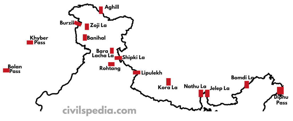
Side Note: Important Passes in the Himalayas
As previously discussed, the Himalayas and associated mountains have many passes. These types of questions can be asked in the exam. Hence we are going to provide a list in concentrated form
Aghill pass
Ladakh
Connects
Ladakh with Xinjiang province.
Burzil Pas
Ladakh
Connecting link between India and Afghanistan and other Central Asian countries.
Zoji La
J&K and Ladakh
Connects Kashmir valley with Ladakh.
Bara Lacha La
Himachal
Connects Manali in Himachal Pradesh to Ladakh.
Shipki La
Himachal
River Satluj enters
India through it and it is the sole trade route between India and Tibet
Lipulekh
Uttarakhand
– It is at the trijunction of India (Uttaranchal), Nepal and China. – Kailash Mansarovar Yatra use this pass – It was in the news due to the Kalapani dispute with Nepal because Lipulekh sits at the top of Kalapani.
Jelep La
Sikkim
Tri
Junction of India, Bhutan and China
Nathu La
Sikkim
Important trade route between India and China
Bomdi La
Arunachal
Connects Arunachal with Lhasa.
Diphu Pass
Arunachal
Tri Junction of India, Myanmar and China
Khyber Pass
Pakistan
Connects Pakistan and Afghanistan (but important because in history, invaders used this to invade India, and traders used this for trade with Central Asia)
Bolan Pass
Pakistan
In Pakistan (has the same history as that of Khyber Pass)
Kora La
Nepal
Connects
Nepal and Tibet
Banihal & Qazigund
J&K
Connects Jammu to Kashmir & contains Jawahar Tunnel
Rohtang Pass
Himachal
Side Topic: Important Glaciers
Siachin Glacier
UT of Ladakh
In the Karakoram Ranges. It is the longest glacier outside the polar regions.
Baltoro
UT of Ladakh
Situated in the
Ladakh ranges
Gangotri Glacier
Uttarakhand
Source of Ganga river
Yamnotri Glacier
Uttarakhand
Source of Yamuna river
Pindar Glacier
Uttarakhand
Source of Pindar river
Zemu Glacier
Sikkim
Source of Teesta river
Importance of Himalayas
Climatic Importance
The Himalayas protect us from the extremely cold winds coming from the north.
The Himalayas also forces southwest monsoon winds to shed whole moisture in India.
Due to the obstruction of the Himalayas, the Westerly Jetstream shed rainfall and snowfall in winters, known as Western Disturbances.
Rivers
The Himalayas are the source of perennial rivers which has deposited large amount of alluvium, forming the Great Plains of India.
Various major rivers of India originate from the Himalayas. These rivers are a source of irrigation for a significant portion of agriculture in India.
They are the source of Hydroelectric power.
Biodiversity
Himalayas go through different bio-geographic and climatic zones. There is a succession of vegetation from topical to tundra. Hence, biodiversity is very high in the Himalayas with large endemism.
Many animals, including tigers, snow leopards, elephants, rhinoceros, etc., are found in the Himalayas.
A large number of herbs of medicinal value are also found in the Himalayas.
Tourism and Religious Importance
Tourists from all over the world visit the hill stations situated in the Himalayas. E.g. McLeod Ganj, Shimla, Nainital Mandi, Mussoorie, Darjeeling etc.
Various religious places are also part of the Himalayas, e.g. Kailash, Amarnath, Kedarnath, Vaishno Devi, Jawala Ji, Chintpurni, Gangotri, Yamnotri, Hemkund Sahib etc.
Mineral Resources
The Himalayas are rich in metallic minerals such as copper, lead, zinc and gold.
The Himalayan rock salt is used in traditional medicines and aromatherapy.
The Siwaliks are a very good source of limestone.
Coal is found in Jammu & Kashmir (Kalakot) and Arunachal Pradesh (Namchik-Namphuk)
Petroleum in India was first discovered in the Himalayas in the upper Assam region.
This article deals with ‘The Cycle of Seasons in India.’ This is part of our series on ‘Geography’, which is an important pillar of the GS-1 syllabus. For more articles, you can click here
Introduction
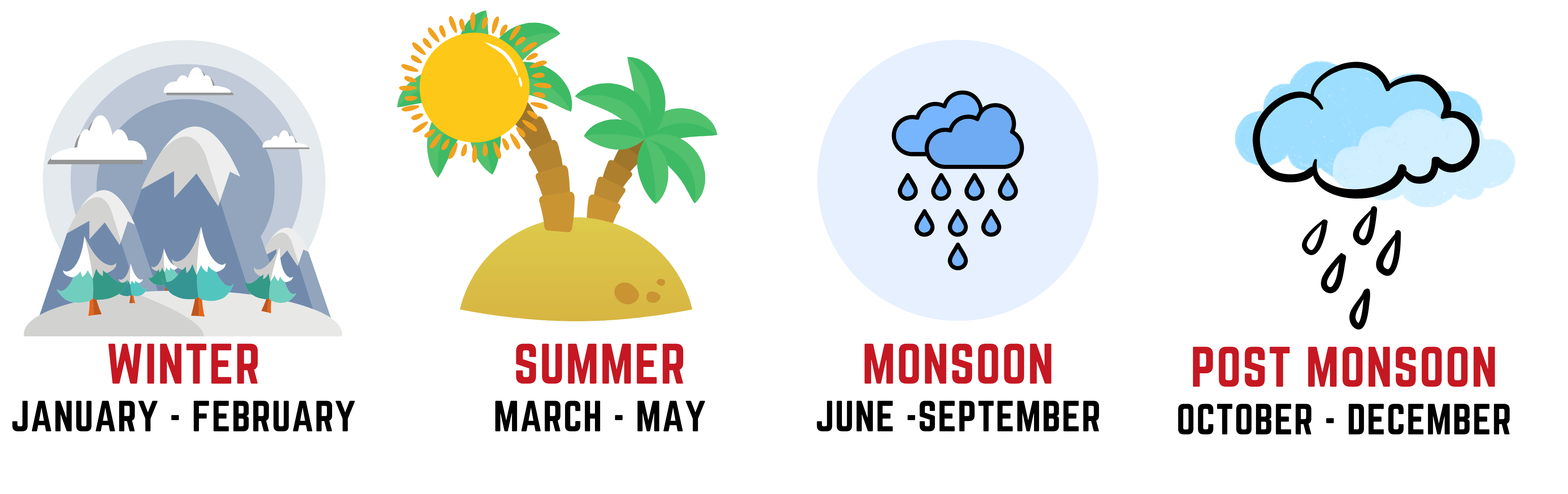
India has four seasons as mentioned below.
Winter Season
Winter season commences in January and remains till the end of February.
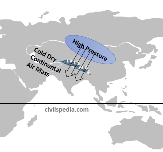
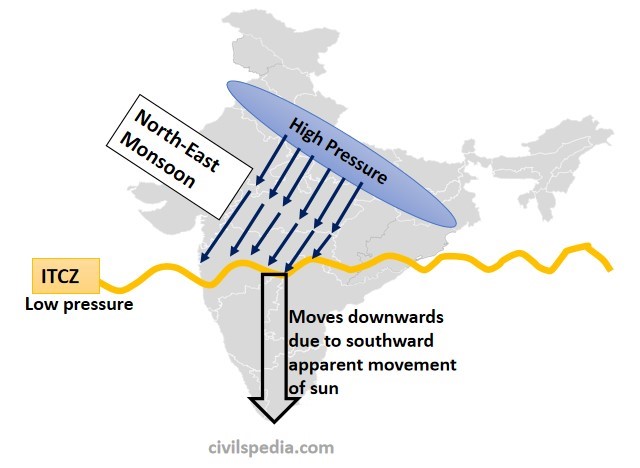
During this period, due to the sun’s apparent movement towards the south, vertical rays of the sun fall over the Southern Hemisphere. That is why the temperature starts to decrease in the Northern Hemisphere, and pressure belts along with Inter Tropical Convergence Zone (ITCZ) start to move southwards.
As the temperature over Indian Subcontinent starts to decrease in winter, the pressure starts to increase. The high pressure replaces the low pressure over Northern India.
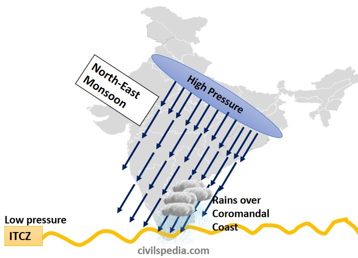
The Inter-Tropical Convergence Zone (ITCZ) starts to move southwards and gradually moves out of India. As a result, monsoon winds also start to retreat, moving towards ITCZ, i.e. from North-West to South-East. These winds are dry as they move from land towards the sea and have already shed moisture. These are known as retreating monsoon or North East Monsoon.
Cold Waves
During this period, high-pressure areas develop over central and western Asia. Dry and cold continental winds from the Caspian Sea and Turkmenistan enter the Northern Plains, which cause a fall of many degrees in the temperature of the great plains. These north-western cold winds, moving at a speed of 3 to 5 km per hour, are termed as the Cold Waves.
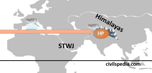
Jet Stream and Upper Air Circulation
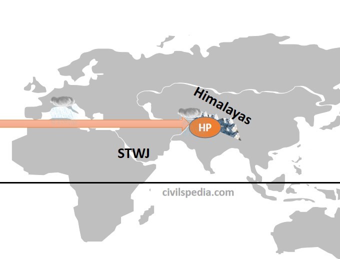
Along with that, Sub-Tropical Westerly Jet (STWJ), flowing over Tibet Plateau in the summers, shifts southwards and creates high pressure over North India. STWJ extends from the Mediterranean sea to Western Asia, the Persian Gulf, Iran and Pakistan, crosses the great plains of India and reaches the China sea.
Rainfall due to North East Monsoon over Coromandal Coast in Winter
Rain occurs in winter due to the North-East monsoon as well.
When Inter-Tropical Convergence Zone (ITCZ) moves out of India, dry continental winds start to blow from North East to South-West.
But a part of North-East winds pass over the Bay of Bengal & cause rainfall on the Coromandal Coast. It is known as North-East Monsoon and precipitates over Coromandal Coast only.
Western Disturbances
Sub-Tropical Westerly Jet reaches Northern India after passing over the Mediterranean Sea, where it rains during winter. These winds bring cyclonic disturbances formed over the Mediterranean Sea to north India.
Due to Sub-Tropical Westerly Jet,
Punjab, Haryana, northern Rajasthan, Jammu and Kashmir and Western Uttar Pradesh receive an average of 20 to 50 cm of cyclonic rainfall, which is very useful for the Rabi crops.
Neighbouring Himachal Pradesh, Kashmir and Kumaon Hills experience snowfall.
Precipitation during the winter season is good for Rabi crops, especially wheat.
But excessive rainfall can also cause crop damage, landslides and avalanches.
Weather in Cold Season
The weather is pleasant in winter.
Days are pleasantly warm (moderate)
Nights are cold.
Skies are clear with dry weather.
Temperature decreases from south to north. It falls from 31° C in Trivandrum, 26° C in Calicut, 24° C in Chennai, 16° C in Varanasi, and Drass Valley has a temperature of -45° C
Due to the sharp fall in night temperature, sometimes dense or heavy fog appears.
Due to the cold waves in the plains, a severe frost occurs.
Summer Season
At the end of February, the temperature rises as sun-rays fall vertically over areas north of the equator. Hence, the summer season remains from March till the end of May, and it is the longest season in India.
Interior areas record the maximum daily temperatures. E.g., The maximum daily temperature recorded is
38° C in Nagpur
40° C in Madhya Pradesh
45° C in the North-Western parts
48° C in the Barmer (Rajasthan)
But coastal lands have moderate climates due to moderating effect of ocean and sea breeze. The temperature remains between 30 to 32° C in South India.
Pressure Systems
With an increase in temperature, Inter-Tropical Convergence Zone (ITCZ) starts shifting towards the north.
In May and June, due to high temperatures, a low-pressure Thermal Depression develops in the north–western parts of the country. Additionally, the Sub-Tropical ‘Jet’ stream shifts towards the north of the Himalayas. In this way, a special situation develops in the north–west, in which till the height of 6–7 Km from the surface of the land, the low-pressure cycles join each other and attract the monsoon winds fastly towards themselves.
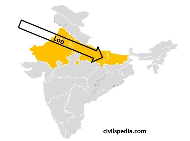
Loo
In summer, North India comes under the influence of
Loo. Loo is a strong, dusty, hot, and dry summer wind blowing from the west
over the western Indo-Gangetic plains region of Northern India. It is
especially strong in May and June. Due to its very high temperatures, exposure
to it leads to fatal heat strokes. Due to its high temperature and dryness, it
has severe drying effects on vegetation leading to browning in the areas it
affects.
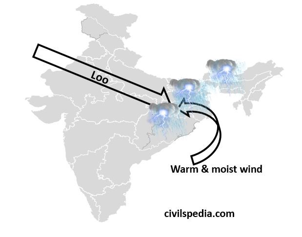
Norwesters or Kalbaisakhi
The Loo ends in late summer due to the arrival of the monsoon. Loo (dry winds at high temperature) from the North-West and warm & moist winds from the Bay of Bengal converge around the Chotanagpur plateau. It causes thunderstorms and lightning accompanied by strong winds and heavy rainfall, mainly in the states of Assam and West Bengal.
These local winds are known as ‘Norwesters’ or ‘Kalbaisakhi,’ i.e. calamity of the month of Baisakh. They bring rainfall in Assam, West Bengal and Odisha. This rainfall is quite beneficial for the cultivation of Jute and Rice in West Bengal and Tea in Assam.
Blossom and Mango Showers
The coastal areas of Kerala and Karnataka receive rainfall close to the end of summer. These showers are extremely useful in the cultivation of tea, coffee and mango. They are also known as Mango Showers in Kerala (as they help in the early ripening of mangoes) and ‘Blossom Showers‘ in Karnataka, as with these showers, coffee flowers blossom in these areas.
Monsoon Season
Due to the
rapid temperature increase in May over the north-western plains, the
low-pressure conditions further are intensified. By early June, low pressure is
powerful enough to attract the monsoon winds from the Indian Ocean. (we have
discussed this already in the previous article)
The rain in this season begins abruptly. This sudden onset of
monsoon with violent thunder and lightning is called the “burst” or “break” of the
monsoons. The monsoon burst can happen in the first week of June in
coastal Kerala, Karnataka, Goa and Maharashtra, while it may be delayed to the
first week of July in interior parts.
With the onset of monsoon winds, the weather conditions change in
the whole country. Its chief characteristics are
High heat
High humidity
Extensive clouding
Several spells of heavy to moderate rain with strong surface winds
Side Topic: Long Period Average (LPA)
LPA is the average annual rain received by the country during the South-West monsoon (June to September) for 50 years.
For 50 years ranging from 1960 to 2010 (used by IMA presently), India’s LPA is 88 cm (approx.)
Deficient
If rainfall is less than 90% of LPA.
Below Normal
If rainfall is
between 90-96% of LPA
Near Normal
If rainfall is
between 96 to 104% of LPA
Above Normal
If rainfall is
between 104% to 110% of LPA
Excess
If rainfall is
above 110% of LPA
March of Monsoon Winds in India
When
moisture-laden winds reach the southernmost tip of the Indian Peninsula, it
divides into two parts due to its topography. These branches are the Arabian
Sea Branch and the Bay of Bengal Branch.
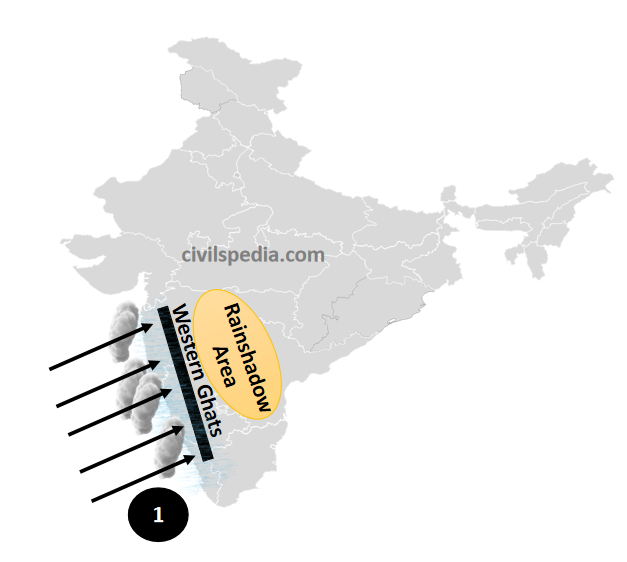
1. Arabian Sea Branch
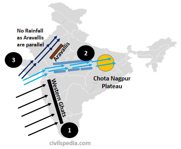
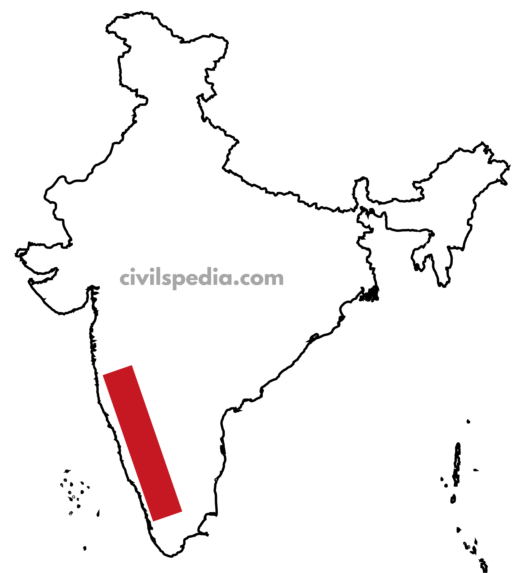
First of all, it encounters the Western Ghats. Full of moisture, when this branch tries to cross the 2000 metres-high Western Ghats, it gets cooled at the ‘lapse rate’ and starts raining. But it rains only on the windward side, i.e. western slopes of Western Ghats, while the leeward side, i.e. South Karnataka Plateau, Rayalaseema, Vidarbha etc., receives very scanty rainfall. Also, the amount of rainfall decreases as the moisture decreases while moving north of the Arabian Sea. For example, Mangalore receives 330 cm. of rainfall, and Mumbai receives 100 cm.
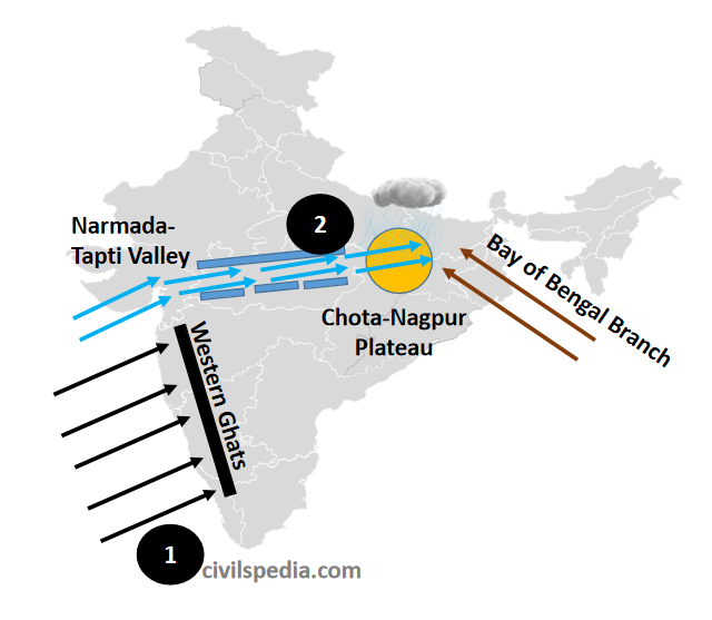
The second sub-branch of the Arabian Sea moves through the valleys of Narmada and Tapi and reaches the Chota-Nagpur Plateau, where it joins the Monsoon winds coming from the Bay of Bengal and causes more than 150 cm of rainfall.
Third sub-branch of the monsoon winds of the Arabian sea moves towards the north, through Gujarat and Sind delta. It causes very less rainfall over Kutch, Saurashtra and Thar Desert due to the following reasons.
By this time, the moisture content is largely decreased
Aravalli range is parallel to these winds, and these just move straight, without rising high, along these mountains.
On reaching Punjab, Haryana and Himachal Pradesh, these monsoon winds join the Bay of Bengal monsoon branch and bring rainfall to these regions.
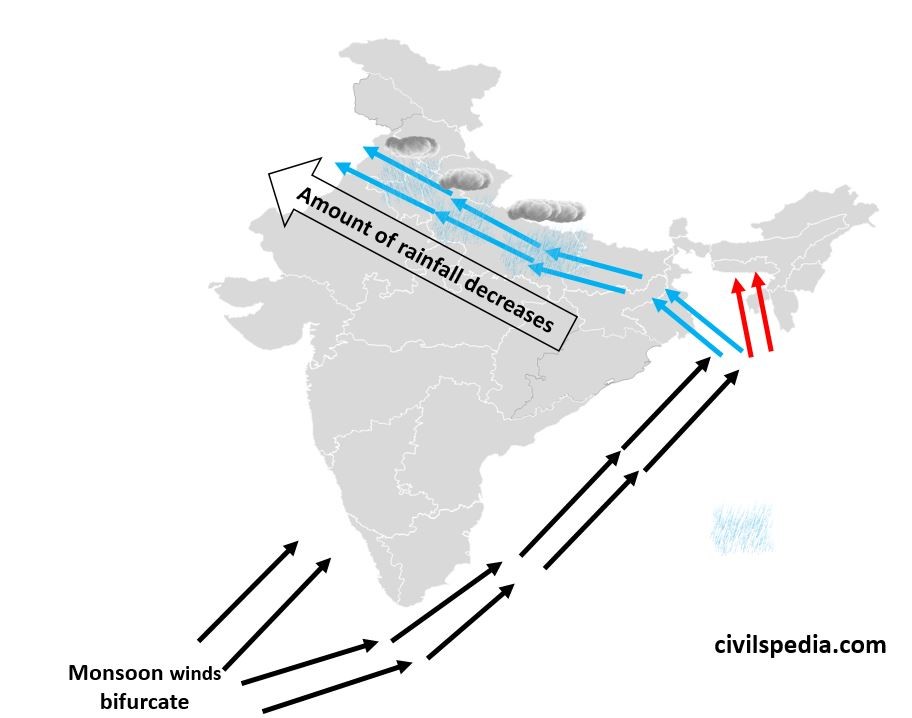
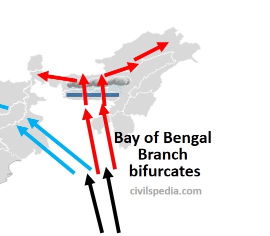
2. Bay of Bengal Branch
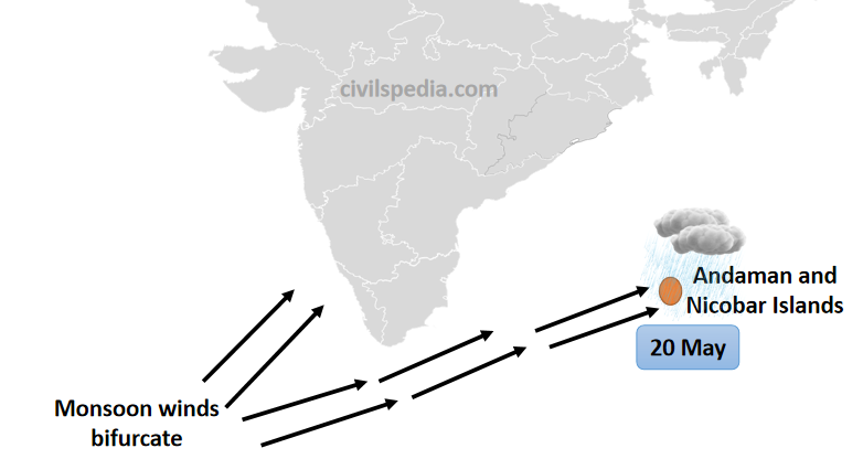
First of all, Monsoon winds hit Andaman and Nicobar Island on 20 May (MCQ = first of all, it hit A&N . Hit Western Ghats and North East on 1 June)
Bay of Bengal Branch is then directed towards Myanmar and South-East Bangladesh. However, owing to the presence of Arakan Yoma hills along the coast of Myanmar, a large part of the Bay of Bengal Branch is deflected towards the Indian subcontinent. The monsoons, therefore, enter West Bengal and Bangladesh from the South and South-East.
The Bay of Bengal branch then bifurcates into two branches. One branch moves along the Ganga Plain, pouring rain on the Northern plains. It rains very heavily in West Bengal. But by the time monsoon winds reach Punjab and Haryana, they become dry resulting in lesser rainfall over these regions. The rainfall decreases from East to West, i.e. Kolkata receives 120 cm, Patna receives 102 cm, Allahabad receives 91 cm, Delhi receives 56 cm, Ludhiana receives 40 cm, and Amritsar receives 25 cm from the Bay of Bengal branch.
The second sub-branch of the Bay of Bengal Branch moves towards the Brahmaputra valley. First, it strikes the Garo, Khasi and Jaintia hills of Meghalaya. While crossing the 1500 m high hills, these saturated winds bring heavy rainfall. Chirapunji and Mawsynram, which are situated in the southern part of Khasi hills, receive the highest average rainfall in the world. Then these winds move towards Assam and Arunachal Pradesh and cause rainfall in Guwahati, Darjeeling etc.
Note: Tamil Nadu Coast doesn’t receive any rainfall from the Bay of Bengal branch because the Tamil Nadu Coast is situated parallel to the direction of the Bay of Bengal Branch and in the rain-shadow area of the Arabian Sea branch.
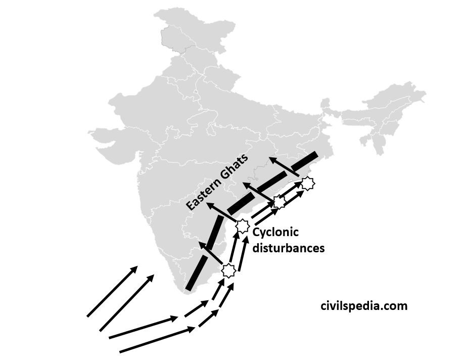
Depressions in the South West Monsoon
An
Easterly Jet Stream flows in the Upper Troposphere of the southern part of
Peninsular India in June. It is confined to 15 N in August and 22 N in
September. This Easterly Jet Stream usually does not extend north of 30 N.
ITCZ while passing over the Bay of Bengal, cause the formation of Tropical cyclones in the Bay of Bengal. These Tropical cyclones are then steered inwards through the gaps in the Eastern Ghats (made by the eastern flowing rivers) by the Tropical Easterly Jet Streams and cause cyclonic rainfall.
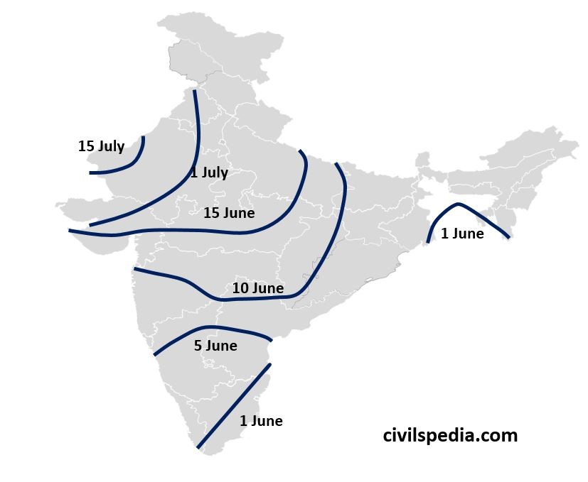
Dates when South West Monsoon hits various regions
Characteristics of the Indian Monsoon
Some of the unique features of the Indian monsoon are
Sudden onset: start of the monsoon is very abrupt.
Gradual advance: once started, it advances very slowly & gradually
Gradual retreat: monsoon winds go back slowly
Seasonal in Character: Rainfall received from the southwest monsoon is seasonal in character and occurs only between June & September.
Largely governed by topography: Monsoon rains are governed by the region’s topography. E.g., Western ghats receive massive rainfall, and Aravallis receive almost none (explained above).
Monsoon has ‘breaks,’ i.e., wet spells of few days interspersed by rainless days.
Monsoon has Variations: These variations are both regional & temporal.
Variation in Monsoon
We will cover both
Temporal and Spatial Variation when asked about variations.
1. Temporal Variations
The
distribution of rainfall varies temporally during the four seasons.
Winter Season
In winter, there is little rainfall in regions of India.
The reason for the winter rainfall in North-West India is Western Disturbances.
Summer Season
In Summer, torrential local rains happen when there is a sudden contact between dry and moist air masses.
South-West Monsoon season
The four wet months of June through September account for more than 80% of the annual precipitation.
In the coastal regions, the monsoon begins in the first week of June; however, it may not begin until the first week of July in the nation’s interior parts.
Rainfall from monsoons is mostly influenced by relief or topography, and it tends to decrease as one gets farther from the sea.
Retreating Monsoon
In response to the sun’s southward march, the monsoon begins to weaken around the end of September.
India’s north experiences dry weather, whereas the Coromandal Coast experiences rain.
2. Spatial Variations
Areas of High Rainfall (Over 200cm): Maximum rainfall occurs along mountain ranges that block moist winds, such as the west coast, as well as in sub-Himalayan regions in the northeast, such as the Garo, Khasi, and Jaintia hills.
Areas of medium Rainfall (100-200 cm): Medium rainfall happens in the north-eastern Peninsula covering Orissa, Jharkhand, Bihar and eastern Madhya Pradesh, east Tamil Nadu, southern parts of Gujarat, and northern Ganga plain.
Areas of low Rainfall (50-100 cm): Most regions showing continentality, like Jammu and Kashmir, Punjab, Haryana, eastern Rajasthan, Western Uttar Pradesh, Delhi, Deccan Plateau and Gujarat.
Areas of inadequate Rainfall (Less than 50 cm): In Ladakh, western Rajasthan and the Interior Peninsula (Andhra Pradesh, Karnataka and Maharashtra)
4. North East Monsoon /Retreating Monsoon
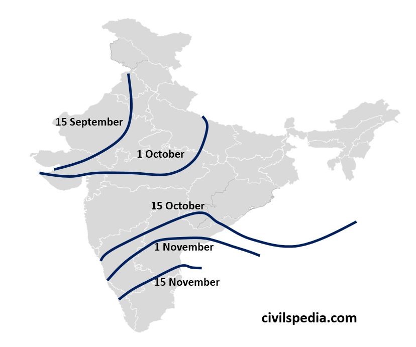
Rain happening in October and November is known as Retreating Monsoons.
The Inter-Tropical Convergence Zone begins moving southward in response to the sun’s southward movement towards the end of September, which weakens the southwest monsoon. Hence, the temperature in the Northern Plains starts decreasing, and consequently, pressure starts increasing. In response to this, Monsoon winds start to retreat from northern India, and this is also known as North-East monsoon as the winds blow from North-East to South-West.
These monsoon winds retreat in almost the same sequence as they arrive in the country.
They first leave Punjab till 15 September,
Uttar Pradesh till 1 October,
Ganges Delta till 15 October
Till 15 November, these leave southern parts of Karnataka and Andhra Pradesh.
The retreat of the monsoon is marked by clear skies and a drop in the night temperature. But the land still remains moist. The combination of high temperature and humidity gives rise to oppressive weather and is known as ‘October Heat.’
The North-East monsoons are generally dry as they originate on land except on the coastal areas of Tamil Nadu, i.e. Coromandal coast because when they pass over the Bay of Bengal, they collect moisture and shed that moisture on the Tamil Nadu coast.
Cyclones on the Eastern Coast during retreating monsoon
Due to the shifting of ITCZ over the Bay of Bengal and the convergence of winds on both sides of ITCZ, cyclonic depressions are created in the Bay of Bengal, whose water is already at high temperature due to continuous heating throughout the summers. These cyclones move towards the west or north-west.
These cyclones frequently hit the eastern coastal region and cause significant damage to life and property. The areas most vulnerable to these storms include the coastal belt of Tamil Nadu, Andhra, Odisha and West Bengal.
The number of devastating severe Cyclones hitting the Indian coasts has been increasing owing to the increase in sea surface temperature in the northern Indian Ocean.
This article deals with the ‘Knowledge-Based Industry in India.’ This is part of our series on ‘Geography’, which is an important pillar of the GS-1 syllabus. For more articles, you canclick here.
Introduction
The advancement in information technology has profoundly influenced the country’s economy. The Information Technology (IT) revolution opened up new economic and social transformation possibilities.
The Indian software industry has emerged as one of the fastest-growing sectors in the economy.
A majority of the multinational companies operating in the area of information technology have either software development centres or research development centres in India.
Knowledge-Economy
Knowledge-Economy is primarily based on intangible assets such as the value of its workers and IPR. These sectors include Space, Pharma, IT, e-learning etc.
India’s competitors in Knowledge-Economy
China
China is the most formidable competitor to Indian companies in the knowledge economy.
ASEAN Nations
ASEAN countries such as the Philippines, Vietnam, Indonesia etc., have graduated with command over the English language, thus encroaching upon the Indian market.
Indian Knowledge-Based Economy
1. Space
India has been able to develop Space Sector due to the support given by the Indian government. But, apart from ISRO, India has not been able to produce a world-class space company (such as SpaceX of the USA)
2. BPO
Indian BPO sector is well developed and is a major contributor to Forex earnings of India.
3. Electronics
The Indian government has not supported developing the electronics sector in the past. Hence, India’s electronics sector was not able to develop.
The present government wants to develop the Electronics sector in India and has started schemes like Production Linked Incentive (PLI) scheme. Companies such as Samsung and Apple have started manufacturing their products in India.
4. Pharma
India is known as the ‘pharmacy of the developing world’ and the 11th largest drug producer globally. But private companies are not spending on R&D and hence not able to produce novel and revolutionary drugs, for which Indians are dependent on foreign companies such as Pfizer, Novartis etc.
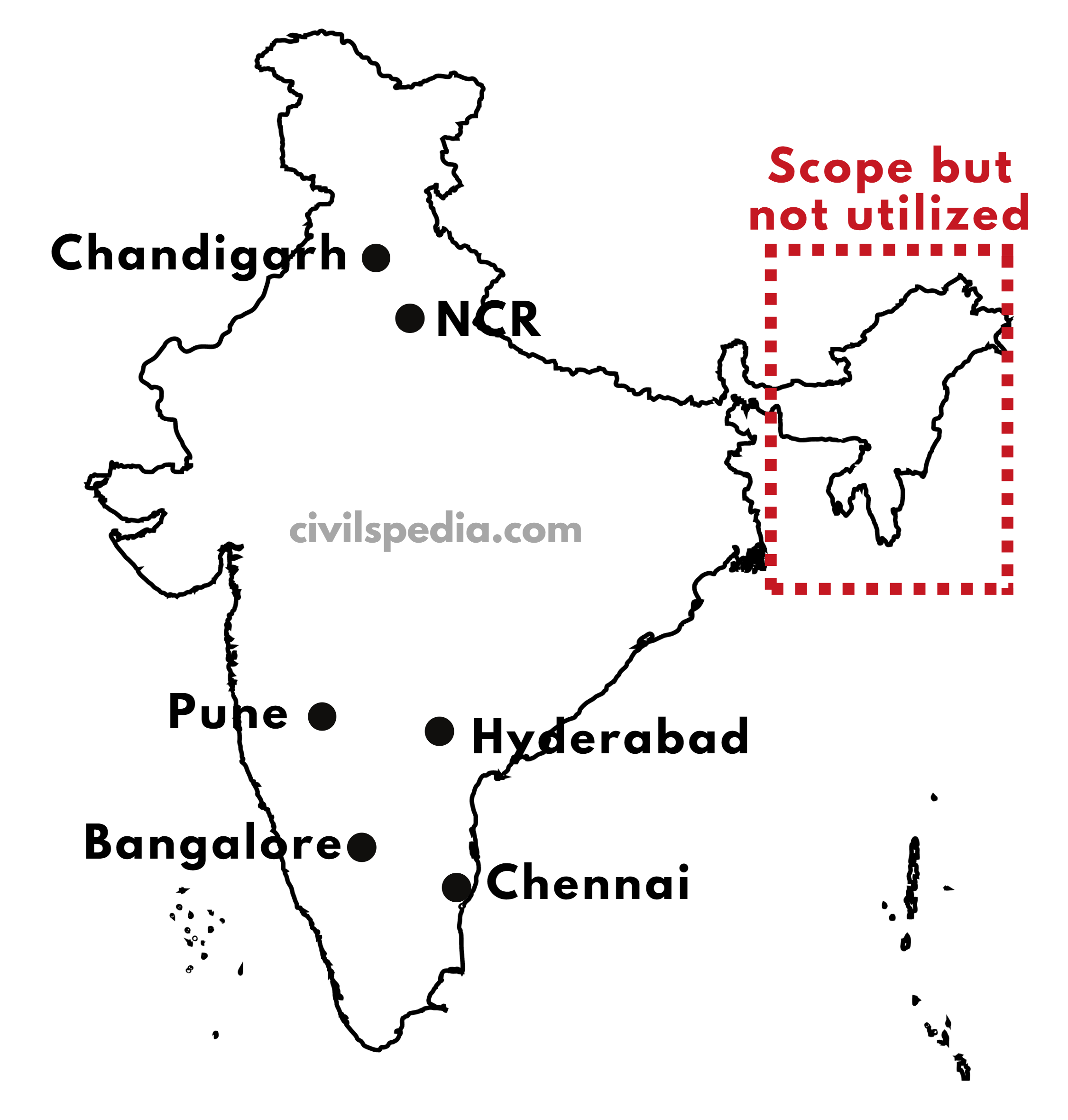
IT Industry in Bangalore. Why?
Bangalore is known as the silicon valley of India.
1. Historical perspective
In the 1950-70s, Bharat Electronics Limited, IISC, National Defence lab, HAL, and ISRO were set up here. It created backward & forward linkages in the field of electronics.
2. Well Connected
The city is well connected by road, railways & air.
3. Skilled Labour
IISC & a large number of institutions around Bangalore provide a large number of professionals to work in the software industry.
4. Progressive Government
The government’s policies helped, like providing land at reasonable rates, tax concessions etc.
5. Pleasant climate
A pleasant climate is a perk for professionals, especially in Tropical countries like India. It is an ideal place to living
But Bangalore has not been able to cope with the rapid increase in population. Due to jammed roads & increased pollution, other cities came up to compete like Pune, Gurgaon, Noida etc.
Challenges faced by India’s IT Sector
1. Loss of Market Access
Indian IT Industry is losing market access
USA: Due to the “Buy American, Hire American” Policy & H1B Visa restrictions
EU has also introduced Data Protection and Privacy Rules (DPPR) that effectively prevent Indian companies from providing services from India, while the US has been given safe harbour status.
2. Competition from new entrants
Indian service companies are now challenged by startups like Luxoft, which are using cloud-based technology, and new digital entrants from Eastern Europe and Latin American countries.
3. Domestic challenges
There are also some domestic challenges like
shortage of skilled talent
underdeveloped infrastructure in Tier 2 & 3 cities
Some restrictive regulations for product startups.
Meanwhile,
the Government of India’s rapid
adoption of technologies as a platform for delivering government-to-government and government-to-citizen
services is a tremendous push factor for the domestic ITBPM market.
This article deals with ‘Climate Funding – UPSC.’ This is part of our series on ‘Environment’, an important pillar of the GS-3 syllabus. For more articles on Science and technology, you can click here.
Introduction
As per the Sharm el-Sheikh Implementation Plan, released during COP27, an annual investment of $4 trillion must be invested in renewable energy until 2030 to reach net zero emissions by 2050. No single source will be sufficient for this amount.
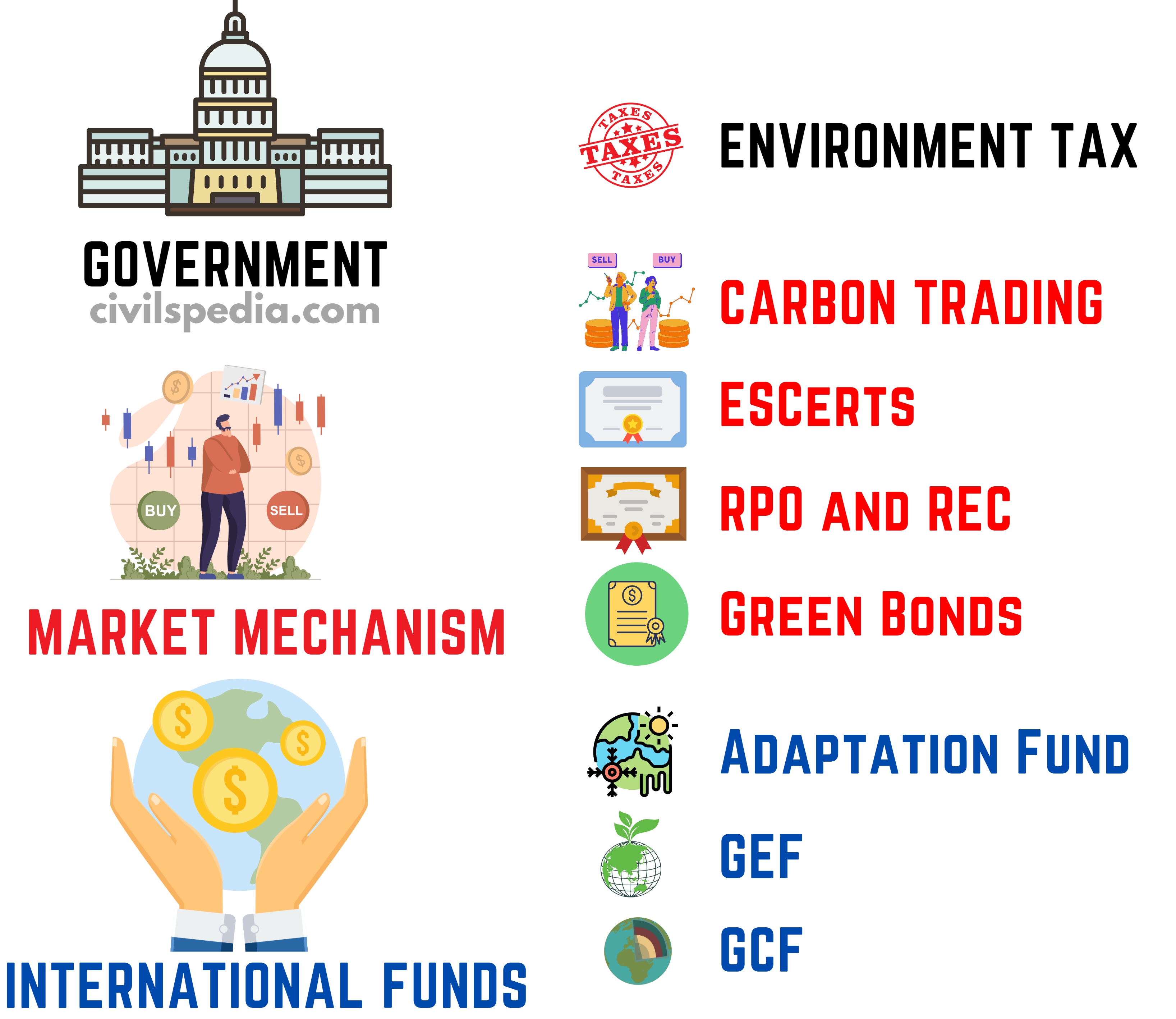
Classification of Finance Sources
We can
classify the cash streams based on who is the prominent player
1. Government Funding
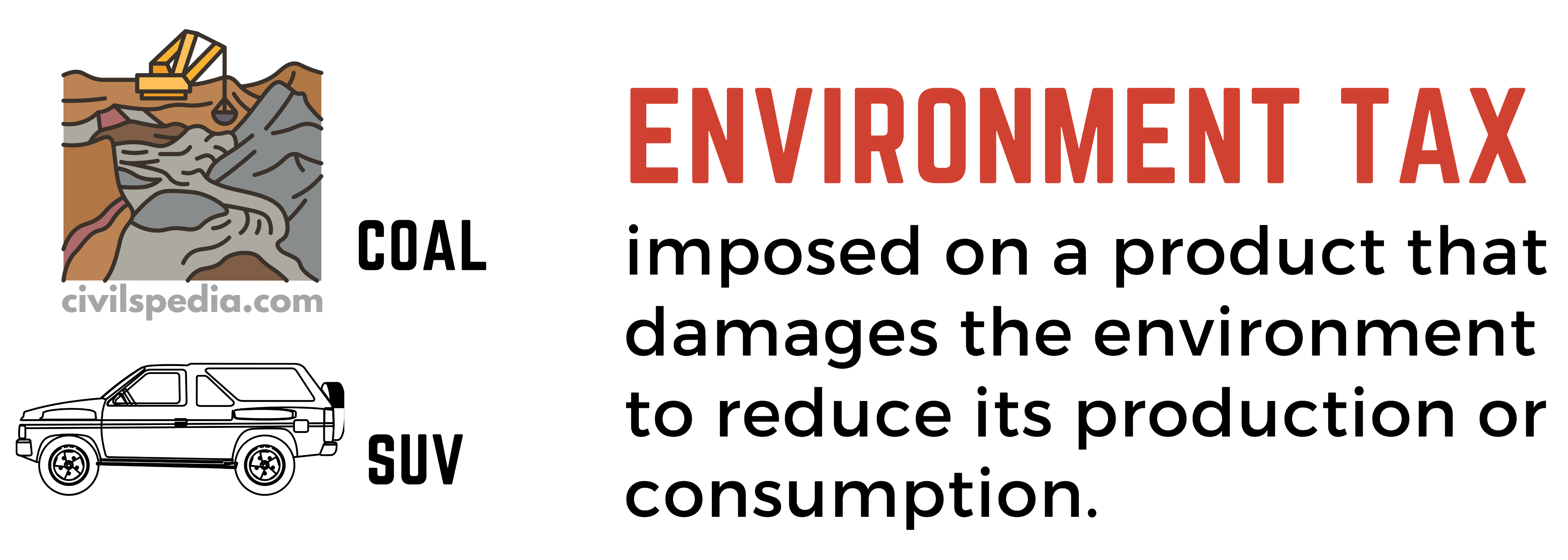
1.1 Environment Tax
An ‘‘environment” or ”green” tax is imposed on a product that damages the environment to reduce its production or consumption.
It is in line with the ”polluter pays principle”.
Benefits of Environment taxes
They internalize environmental costs into prices.
Deter actions that lead to environmental damage
Encourages innovation and development of new technology
Government can use the revenue raised by environmental taxes for development activities and thus reduce the level of other taxes (e.g. income tax or excise duty on medicines)
Government’s initiatives in this regard
1. Clean Environment Cess
The government introduced Clean Energy Cess on coal at Rs.50 per ton in 2010.
The rate is subsequently increased to Rs. 400 per ton presently.
The money thus collected is transferred to the National Clean Energy and Environment Fund.
2. Higher Excise Duties on SUV
Government charges higher excise duty on fuel-guzzling SUVs.
2. Market-based Mechanisms
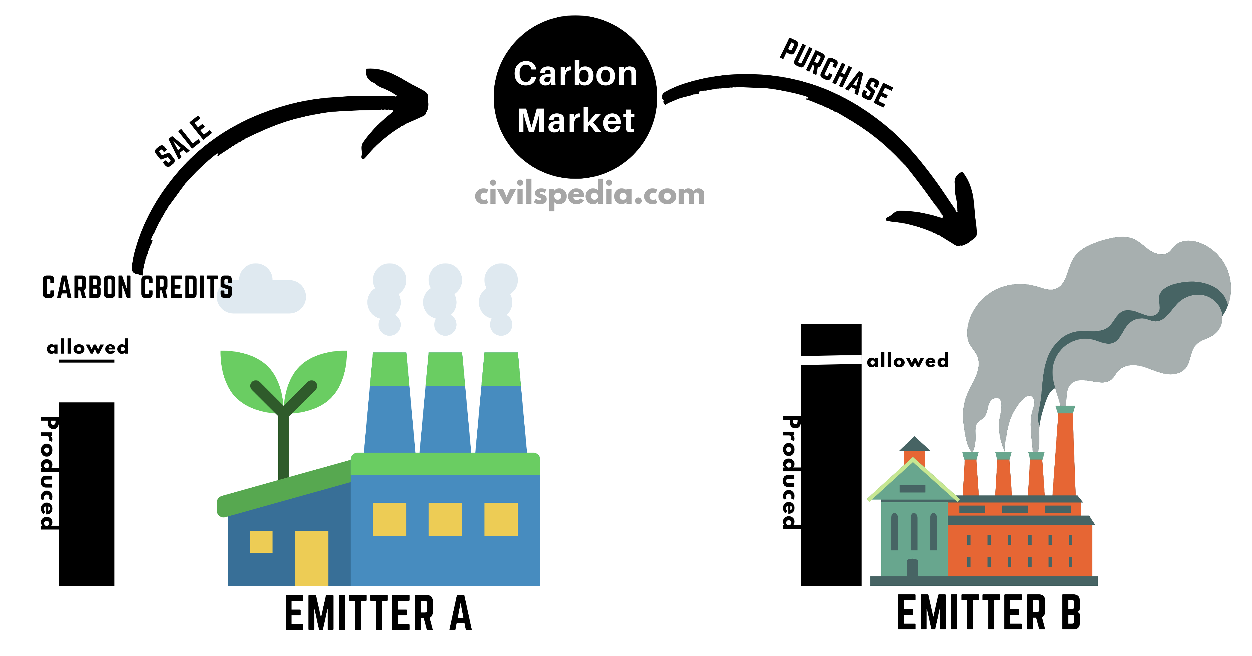
2.1 Carbon Trading or Cap and Trade
Carbon Trading, also called carbon emissions trading, is a market-based system of buying and selling permits and credits that allow the permit holder to emit carbon dioxide. The model used in most carbon trading schemes is called ”cap and trade”.
How does ‘cap and trade’ work?
Setting a cap: An overall limit or cap is set on the amount of emissions allowed from significant carbon sources, including the power industry, automotive and air travel.
Issuance of permits: Governments issue permits up to the agreed limit. Each permit is usually measured in terms of one tonne of carbon dioxide equivalent (CO2e).
Selling and buying of permits: If a company curbs its own carbon significantly below the cap, it can trade the excess permits on the carbon market for cash. If it’s not able to limit its emissions, it may have to buy extra permits.
2.2 PAT (Perform Achieve and Trade) & ESCerts
It was launched by the Bureau of Energy Efficiency (Ministry of Power) under the National Mission for Enhanced Energy Efficiency (NMEEE).
It is a market-based mechanism in which sectors are assigned efficiency targets. Industries that over-achieve targets get incentives through Energy-Saving Certificates (ESCert). Other companies can buy those ESCerts to meet their targets
2.3 Renewable Purchase Obligations (RPO) & Renewable Energy Certificates (RECs)
Under the Renewable Purchase Obligations (RPO) mechanism, DISCOMs must purchase certain percentage of their total energy in the form of renewable energy.
Renewable Energy Certificates (RECs) are provided under the RPO mechanism if DISCOM is using more than the required Renewable Energy. DISCOM is entitled to RECs equivalent to the surplus
Those Discoms, which are not able to use the required Renewable Energy can buy these RECs and claim that they have purchased renewable energy.
2.4 Green Bonds
What are green bonds?
The Green Bond is a type of bond (debt instrument). But the issuer of a green bond publicly states that capital is being raised to fund ”green” (environment-friendly) projects, like renewable energy, clean transportation etc.
It can be issued by Banks as well as Companies.
Timeline
2007
In 2007, green bonds were first launched by European Investment Bank & the World Bank
2015
Yes Bank & later EXIM bank launched India’s first dollar-denominated green bond.
2016
SEBI issued Green Bond guidelines.
2017
L&T issued the first SEBI-approved Green Bonds.
2022
Budget 2022 announced that the Government of India would issue Sovereign Green Bonds (SGB) for projects leading to a less carbon economy.
Importance
India has set an ambitious target of generating 40% of its energy through Renewable sources by 2030 as part of its Paris Climate Deal obligations (INDC). It requires massive funding, and Green Bonds can help in raising that.
Higher interest rates in India raise renewable energy costs by about 25%. Green bonds carry a lower interest rate
Green bonds enhance an issuer’s reputation by showcasing its commitment towards sustainable development.
It allows issuers to tap into pools of global investors & capital funds dedicated to ethical climate change and green investing.
Risks & challenges
Greenwashing: There have been heated discussions regarding whether the projects that green bond issuers fund are environmentally friendly. E.g., Reuters reported how activists were claiming that the proceeds of the French utility GDF Suez’s$3.4 billion green bond issue were used to fund a dam project that hurts the Amazon rainforest in Brazil.
Most green bonds in India have a shorter tenure of about 10 years (compared to international issuances). A typical loan is for minimum 13 years.
Most Indian Green Projects are small and unattractive to investors due to their small scale.
Borrowing costs and information asymmetry: In India, the cost of green bond issuance has consistently remained higher than that of other bonds.
Further steps required
Standardizing the definition of green
Going towards securitization & aggregation: Many standalone green projects such as rooftop solar, energy efficiency, and rural water supply remain unattractive to institutional investors owing to the smaller scale and vast geographical spread. Aggregation and securitization of such projects could be a welcome move in providing mainstream debt to small-scale green projects.
Side Topic: Blue Bonds
It is a sub-type of green bond.
Blue bonds are sustainability bonds used to fund initiatives to preserve and protect the ocean and its surrounding ecosystems. E.g.,
Sustainable fisheries
protection of fragile ecosystems
reducing pollution and acidification
E.g. 2018- Seychelles issued the world’s first ”Blue Bond” to expand its marine protected areas and fisheries sector.
3. International Funds
3.1 Adaptation Fund
Adaptation Fund was established under United Nations Framework Convention on Climate Change (UNFCCC). 2% of the trade of Carbon Credits goes to Adaptation Fund.
From the Adaptation Fund, the funds are sent to the National Implementation Entity (NIE) of countries.
For India, this Agency is NABARD (it is the only NIE in the Asia Pacific)
3.2 Global Environment Facility (GEF)
Global Environment Facility (GEF) was established during the Rio Earth Summit of 1992 to address the world’s most challenging environmental issues.
GEF provides funding for 5 things
UNFCCC
Convention on Biological Diversity (CBD)
Stockholm Convention on POPs
Minamata Convention on Mercury
UN Convention to Combat Desertification
World Bank serve as the Trustee of the GEF
3.3 Green Climate Fund (GCF)
It was established in 2010 at COP 16 held in Cancun.
GCF raise money from rich countries to fight climate change. Projects will be carried out in developing countries to fight climate change using this fund.
The aim is to spend $100 Billion per year from 2020.
Countries have to appoint a National Designated Authority (NDA) that acts as the interface between their government and GCF. India’s NDA is NABARD.
Issues with GCF
How to define Green Climate Finance. E.g :
Will US NGOs (e.g. Ford Foundation or Melinda Gates Foundation) working on providing clean water in Africa be considered within US Green Climate Obligations in Account books? Developed countries are re-categorising all these funds under GCF Obligations.
Is Technology Transfer part of Green Climate Finance? Suppose Patents are transferred like the US transferred patents to produce Solar Cells in India. Will the cost of the patent be counted under GCF obligations? Developed countries are in favour while Developing countries are opposed to this.
Which Countries have the first claim over GCF Corpus? Should AOSIS Nations, which are most affected by Climate Change, get these funds or African Nations or Other developing countries?
Whether to spend it on Mitigation or Adaptation projects
This article deals with ‘Introduction to Mineral Resources of India.’ This is part of our series on ‘Geography’, which is an important pillar of the GS-1 syllabus. For more articles, you canclick here.
Mineral Resources
Minerals are aggregates of two or more than two elements having a definite chemical composition and atomic structure & formed by the inorganic process.
The development of the entire secondary sector is based on minerals. India has vast deposits of minerals.
In the earth’s crust, they are in the form of ore. They are extracted, processed & then utilised for the economic benefit of society.
Minerals have certain characteristics
These are unevenly distributed over space.
There is an inverse relationship between the quality and quantity of minerals, i.e., high-quality minerals are less in quantity than low-quality minerals.
All minerals are exhaustible over time. These take a long to develop geologically, and they cannot be replenished immediately at the time of need. Thus, they have to be conserved & not misused as they do not have a second crop.
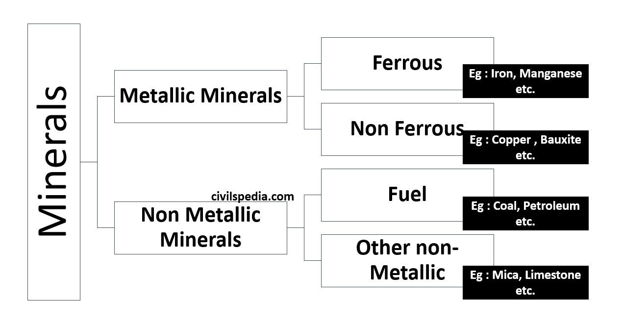
Classifications of Mineral Resources
Classification into Metallic and Non-Metallic Minerals
Classification into Renewable and Non-Renewable Minerals
1. Renewable Resources
Resources which can be renewed or replenished fast
They are always available & not affected by human activities.
E.g., Solar Energy, Wind Energy etc.
2. Non-Renewable Resources
These have been built over a large geological time.
They need to be used judicially & in a planned way.
Fossil fuels, iron, gold etc.
Distribution of Minerals in India
Minerals are mainly associated with metamorphic & igneous rocks of Peninsular India. The vast alluvial plain tract of north India is devoid of minerals of economic use.
Mineral resources provide the country with the necessary base for industrial development.
Each mineral region is associated with a prior geological activity.
Geological Events which led to the formation of Minerals
3 Geological events happened in India due to which minerals are found in those areas.
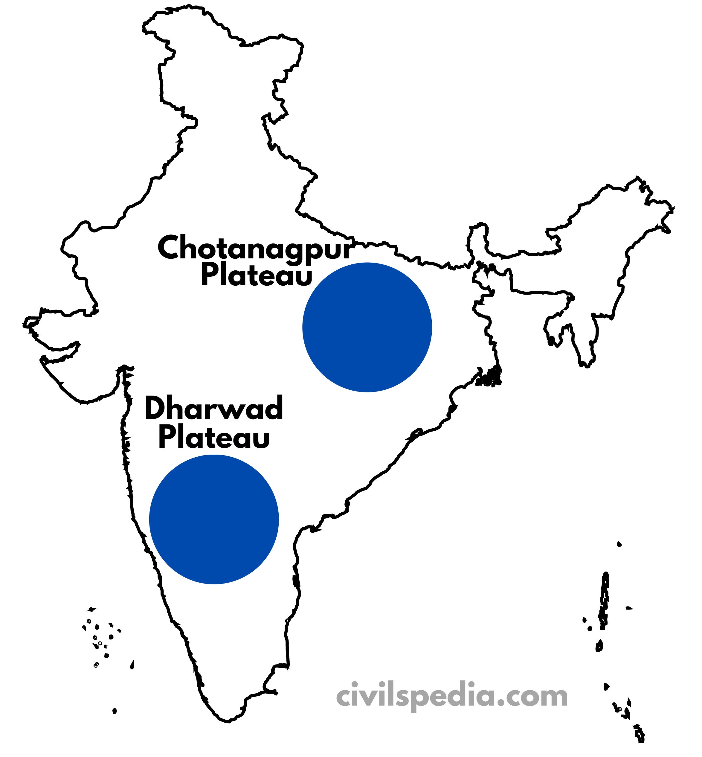
1. Shield Regions
These were mountains millions of years ago but have now eroded to plateaus.
Metallic Minerals are found in large quantities, particularly in Chotanagpur Plateau & Dharwad Plateau.
Reason for minerals: Volcanic Activity when it passed over Reunion Island.
2. Rift Valley during Gondwana Time
During Gondwana times, the rifting along Damodar & Mahanadi led to large-scale forest submergence. Over the years, this has resulted in the formation of Coal deposits.
The main regions where these are found are
Damodar Valley
Mahanadi Valley
Godavari and Wardha Valley
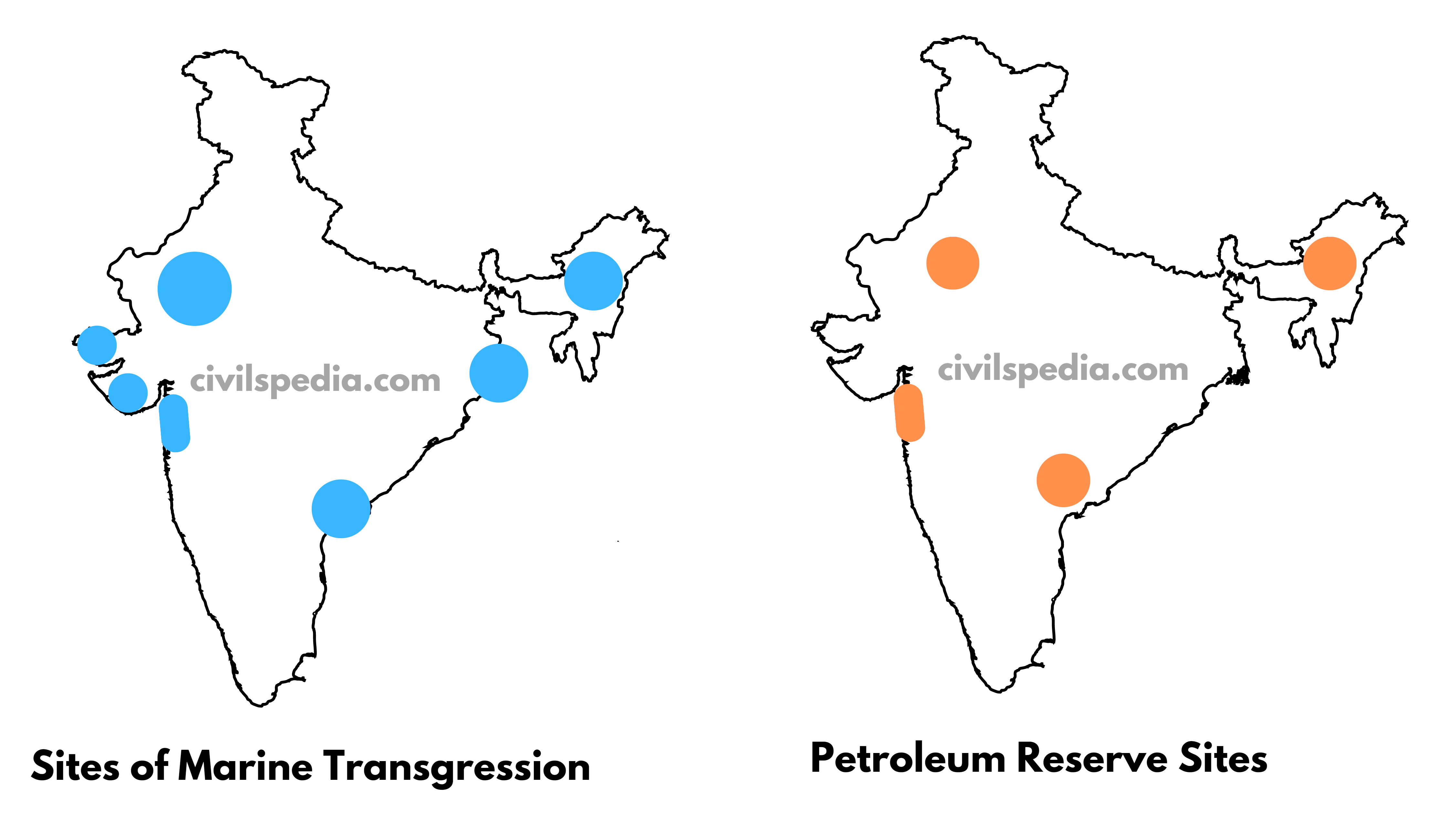
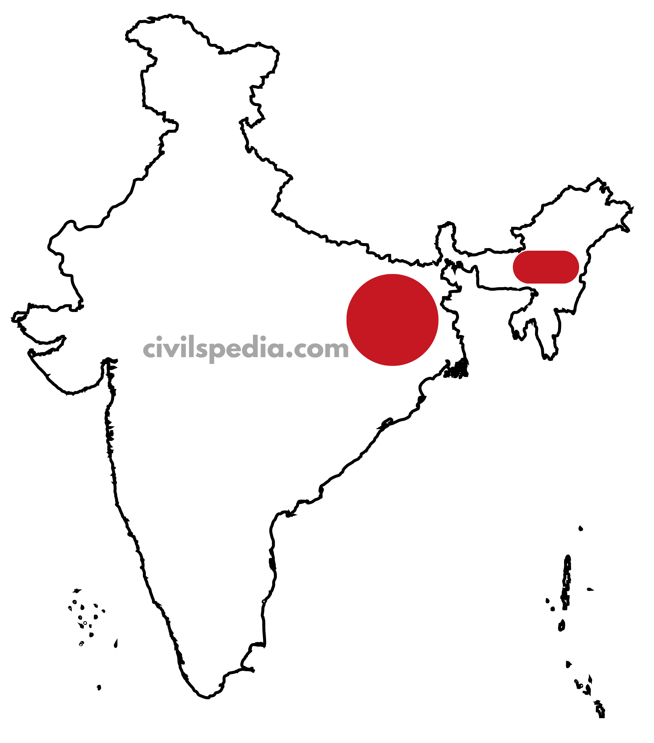
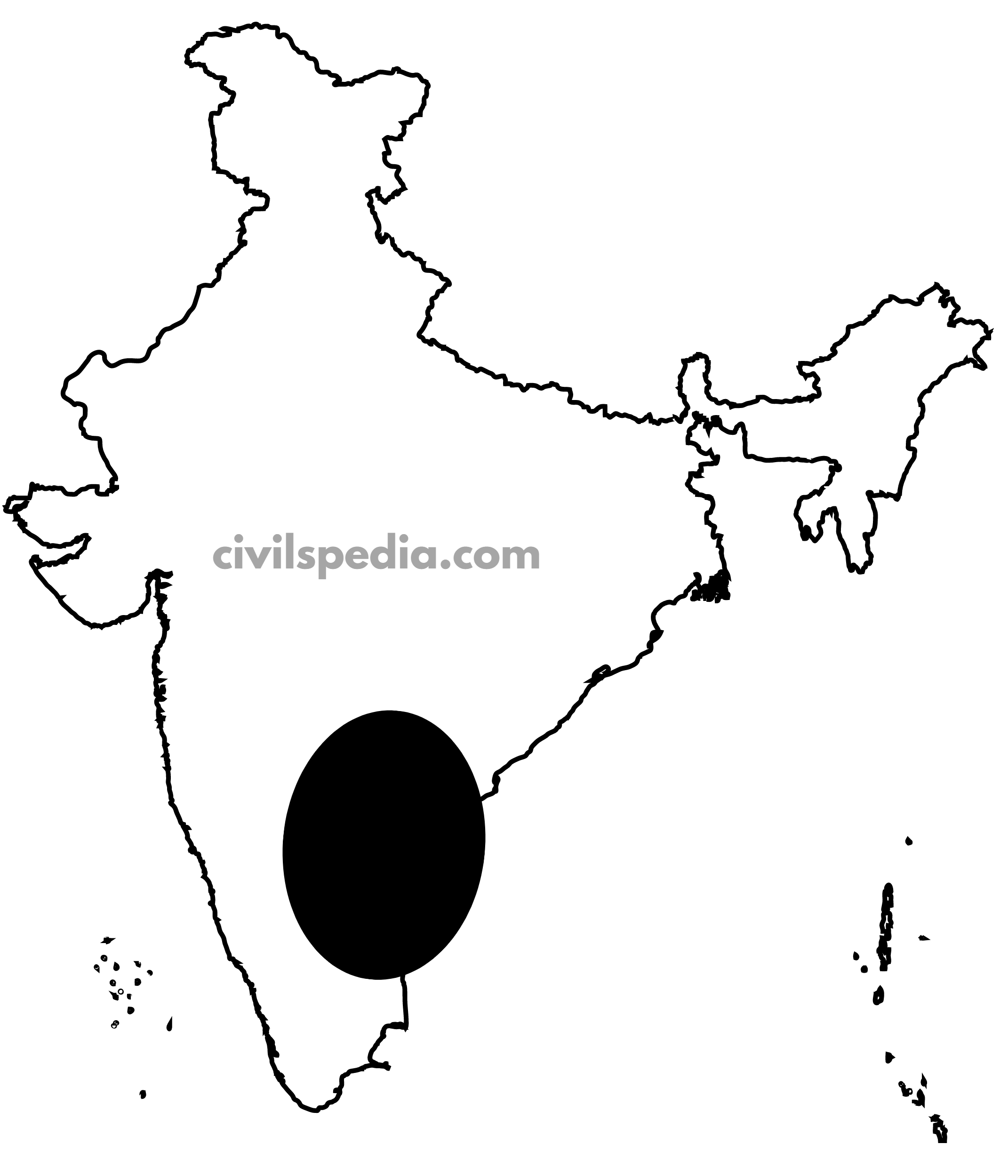
3. Marine transgression during Tertiary time
Petroleum reserves are found at sites of marine transgression.
These regions Include
Gulf of Khambat and Gulf of Kutch.
Brahmaputra-Shillong Shelf
Bengal-Bangladesh Shelf
KG Basin
5 Mineral rich Regions of India
There are 5
mineral-rich regions in India where most minerals are concentrated.
1. Northern-Eastern Belt
It is the richest mineral region of India.
It consists of following
Chotanagpur Plateau
Kyanite (100% of India’s reserves)
Iron (90% of India’s reserves)
Chromium (90% of India’s reserves)
Mica (75% of India’s reserves)
Coal (70% of India’s reserves)
Others: Manganese, Copper and Limestone
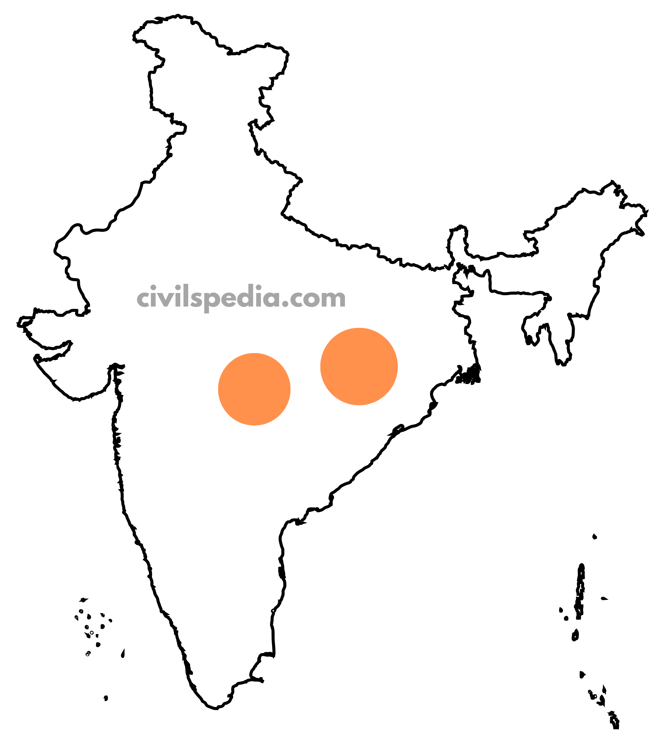
Assam
Petroleum Reserve
Lignite Coal
2. Central Belt
It is
found in the Chhattisgarh region
It is an extension of the Chotanagpur Plateau.
Iron and limestone are found here.
Coal is found here due to the Godavari-Wardha valley rifting.
3. South-East Region
In this region, the
following minerals are found
East Karnataka (Hospet Bellary Region): Iron
Andhra (Cuddapah & Kurnool): Iron
Andhra (Nellore): Mica, Manganese and Coal
Telangana: Bauxite
Tamil Nadu (Neyveli): Lignite coal
4. South-West Region
In this
region, the following minerals are found
Karnataka Dharwar: Iron, manganese, and limestone are found here
Goa: Iron is found here
Maharashtra (Ratnagiri): Iron is found here.
Kerala has deposits of Monazite and Thorium and Bauxite clay.
5. North-West region
In this region, the following minerals are found
Petroleum
Rajasthan: Barmer
Gujarat: Gulf of Kutch
Building material
Rajasthan is rich in building stones, i.e. sandstone, granite, and marble. Gypsum and Fuller’s earth deposits are also extensive. Dolomite and limestone provide raw materials for the cement industry.
From Lakes
Salt from Playa lakes of Rajasthan.
Lake Sambhar and Lake Didwana of Rajasthan – contain gypsum & borax deposits.