Table of Contents
Ganga River System
This article deals with the ‘Ganga River System (UPSC notes)’. This is part of our series on ‘Geography’, which is an important pillar of the GS-1 syllabus. For more articles, you can click here.
Information on Glance
| Origin | Gangotri Glacier |
| Length | 2,525 km |
| Catchment Area | 8.61 lakh sq. km |

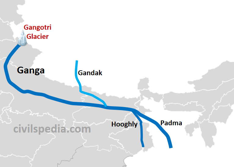
Origin and Flow of River
Origin
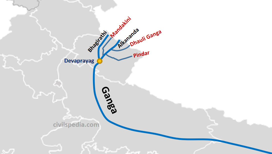
- Ganga originates as Bhagirathi from Gangotri glacier near Gaumukh in the Uttarkashi district of Uttarakhand.
- Alkananda joins Bhagirathi at Devaprayag. But before the river reaches Devaprayag, the Dhauliganga, the Pindar, and the Mandakini rivers pour into the Alaknanda.
- Below Devaprayag, the combined water of the Bhagirathi and Alaknanda flows under the name of the Ganga.
The flow of Ganga in Plains
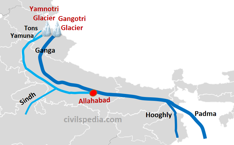
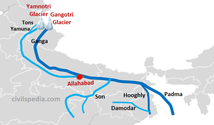
- Ganga enters plains at Haridwar.
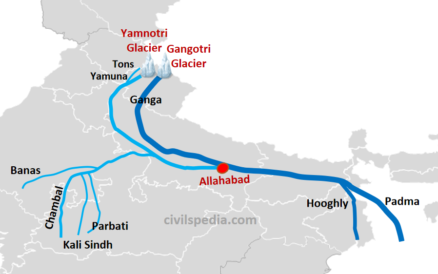
- From here, it flows in south and southeast directions for a distance of 770 km to reach Allahabad, where the Yamuna joins it. After that, it passes through the Bihar plains.
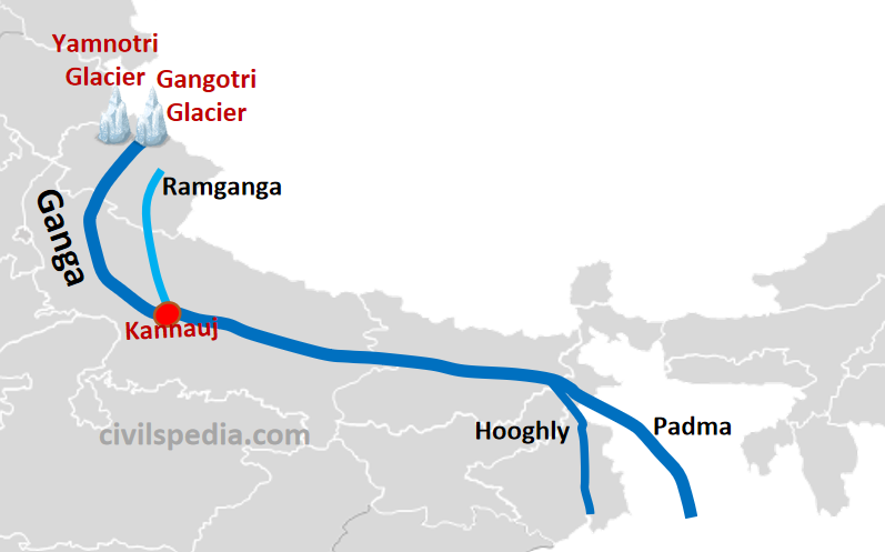
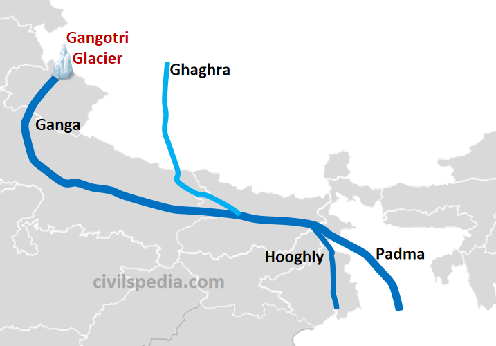
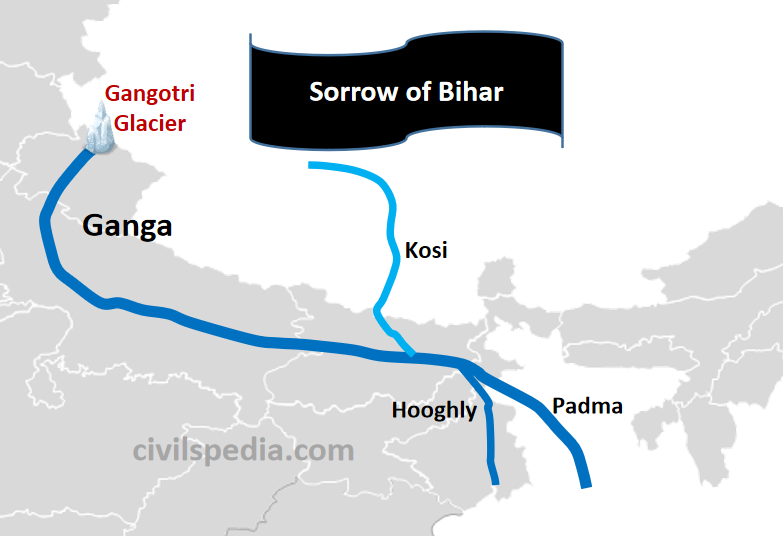
- It ceases to be known as Ganga as it turns southeast and south of Farraka near Rajmahal Hills. It splits into Padma in Bangladesh and Hugli in West Bengal.
- After travelling 220 km further down in Bangladesh, the Brahmaputra (or the Jamuna as it is known here) joins it at Goalundo.
- Further, it meets Meghna and joins the Bay of Bengal.
- The Ganga and the Brahmaputra form the largest delta in the world before entering the Bay of Bengal. The delta comprises a web of distributaries and islands covered by dense forests called the Sundarbans.
Tributaries of Ganga
Numerous tributaries join Ganga, both on the left and the right. Most of them have their origins in the Himalayan Mountains, although some originate from the Peninsular Plateau.
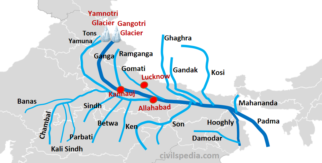
Right bank tributaries of Ganga
Right bank tributaries of the Ganga include Yamuna, Son and Damodar.
1. Yamuna
| Origin | Yamnotri glacier on Bandarpunch peak (Uttarakhand) |
| Length | 1380 km |
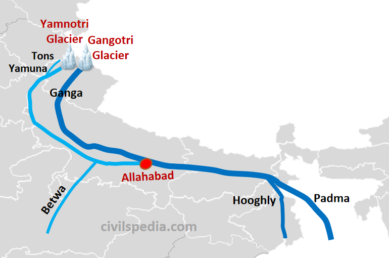
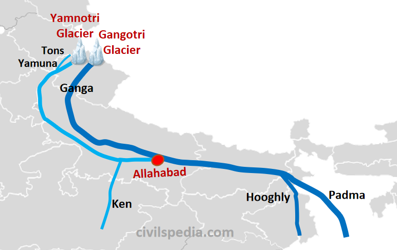
| Important Tributaries | – Originating in the Himalayas: Ton – Originating in Peninsular Plateau: Chambal, Sind, Betwa and Ken |
| Joins Ganga at | Allahabad |
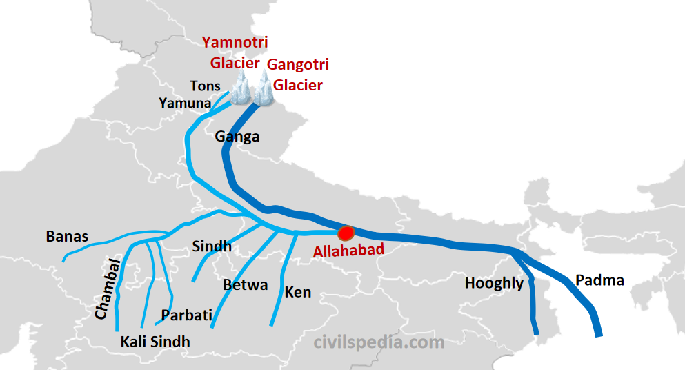
- Yamuna is the largest & most important tributary of the Ganga.
- It originates from the Yamnotri glacier on the Bandarpunch Peak in Garhwal in Uttarakhand (very close to the source of the Ganga).
- In the upper reaches, it is joined by many small streams. The most important tributary of Yamuna in the upper reaches is Tons which also rises from Bandarpunch Peak and joins Yamuna at Kalsi, right before Yamuna leaves the hills.
- After passing through the Himalayas, it enters the plains.
- In the plains, it is joined by Hindon near Ghaziabad.
- Yamuna flows southward till Mathura and southeast after Mathura till Allahabad, where it unites with Ganga.
- Between Mathura and Allahabad, it is joined by Chambal, Sind, Betwa and Ken (tributaries of Yamuna originating from the Peninsular Plateau).
Peninsular Tributaries of Yamuna
1.1. Chambal
| Origin | Near Mhow Cantt in Vindhya Plateau of Madhya Pradesh |
| Length | 1050 km |
| Flow | – After originating near Mhow, it takes a north-westerly course through the Malwa plateau. – It then enters a gorge from Chaurasigarh to Kota (96 km long). – After Kota, it takes a north-easterly turn. Furthermore, at Pinahat, it turns east and flows parallel to Yamuna before joining it at Etawah (UP). |
| Badland Topography | – Chambal is known for its Badland Topography because of the extreme erosion caused by the river. – Badlands are found in MP, Rajasthan & UP & are infested with dacoits. |
| Tributaries | 1. Banas: Originating from Aravali and joining Chambal near Sawai Madhopur. 2. Kali Sind (originate from Vindhyas) 3. Parbati (originate from Vindhyas) |
| Projects | 1. Gandhi Sagar 2. Rana Pratap Sagar (Rawatbhata) 3. Jawahar Sagar |
1.2 Sindh
| Origin | Vindhya Plateau |
| Length | 415 km |
| Flow | After passing through MP, it joins Yamuna in UP. |
1.3 Betwa
| Origin | Bhopal district |
| Length | 590 km |
| Flow | After passing through MP, it joins Yamuna near Hamirpur in UP. |
1.4 Ken
| Origin | Barner Range of Madhya Pradesh |
| Length | 360 Km |
| Flow | – The river passes through the Panna district of MP & makes a gorge at Gangau. – It joins Yamuna in the Banda district in UP. |
2. Son
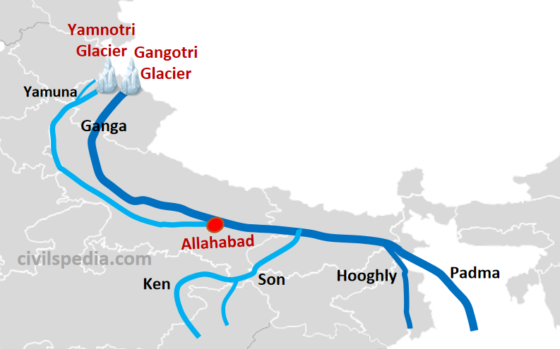
| Origin | Amarkantak plateau in Chhattisgarh |
| Length | 780 km |
| Flow | – The river originates in the Amarkantak Plateau and flows in the north direction. – From the Kaimur range, it takes a northeast turn and passes through the Palamau district of Jharkhand. – Later, it joins Ganga in the Patna district of Bihar. |
| Waterfalls | Son River forms waterfalls when it leaves the plateau. |
| Important tributaries | – Rihand (from Ramgarh Hills) – North Koel (from Chotanagpur Plateau) |
3. Damodar
| Origin | Chotanagpur Plateau |
| Length | 780 km |
| Flow | – After originating from the Chotanagpur Plateau, it flows through the rift valley. – It used to cause devastating floods and earned the name of ‘Sorrow of Bengal.’ –It finally joins Hooghly in West Bengal, 48 km below Kolkata. |
| Points | – India’s first multipurpose river project Damodar Valley Corporation (DVC) located on it with Tilaiya, Maithon & Panchet dams – Damodar Valley is rich in coal deposits & called the Ruhr Valley of India. |
Left bank tributaries of Ganga
Left bank tributaries of Ganga include Ramganga, Gomati, Ghaghra, Gandak, Kosi and Mahananda.
1. Ramganga
| Origin | Garhwal district of Uttarakhand |
| Length | 596 km |
| Flow | – Ramganga rises in the Garhwal district of Uttarakhand and enters Ganga plain near Kalagarh. – It finally joins Ganga at Kannauj. |
2. Gomati

| Origin | Northern UP |
| Flow | After entering the Ganga plains, it passes through Lucknow and finally meets Ganga. |
3. Ghaghra
| Origin | Near Gurla Mandata peak (south of Mansarovar Lake) in Tibet |
| Length | 1080 km |
| Flow | – It originates in Tibet. Then it flows through Nepal, where it is known as Karnali. – After entering the plains, it is joined by important tributaries like Sarda, Sarju and Rapti. Ayodhya is located on the banks of river Sarju. – It finally meets Ganga in the Chhapra district of Bihar. – The river has a high flood frequency and has shifted its course several times. |
4. Gandak

| Origin | Near Tibet-Nepal Border. |
| Length | 435 km |
| Flow | – It originates near the Tibet-Nepal border and receives water from a large number of tributaries in Nepal like Kali Gandak, Bari, Trishuli etc. – It finally enters the plains and joins Ganga at Hajipur (near Patna) in Bihar. |
5. Kosi
| Origin | Tibet |
| Length | 730 km |
| Flow | – Kosi originates in Tibet as Sapta Kosi (i.e. made up of 7 streams in Tibet). – Gradually, tributaries join and are reduced to 3 streams in Nepal, known as Triveni. – These three streams merge & known as Kosi when it enters India. – It enters into the plain region just when it enters India, carrying a lot of sediments & has a large volume of water. Due to sediments, the depth of the basin becomes shallow and the river becomes sluggish, making the braided river channel which shift its course frequently. Due to this, it results in frequent devastated floods and the river is known as the ‘Sorrow of Bihar‘. – But it has been tamed since 1962 by constructing embankments on its rivers. |
6. Mahananda
| Origin | Darjeeling Hills |
| Flow | After entering the plains, it joins the Ganga as its last left bank tributary. (NCERT fact) |
After seeing other websites explaining river system, I can definitely say that this is comparatively the best explanation.
Thank you
Thanks for such a kind review. Please share the word with others.
Wonderful and very helpful for me, Explanation wow🙏🙏🙏. Keep it up, Thanks a lot 👍👍👍
Finally found the right one 👍🏼👍🏼👍🏼 thank you so much
Thank you for this