Table of Contents
Indus River System
This article deals with the ‘Indus River System (UPSC notes) ’. This is part of our series on ‘Geography’, which is an important pillar of the GS-1 syllabus. For more articles, you can click here.
Himalayan River Systems
- There are three major Himalayan River Systems, i.e. the Indus, the Ganga and the Brahmaputra.
- Many Himalayan rivers existed even before the Himalayan ranges were uplifted, corroborated by the gorges of the Indus, the Satluj, the Kosi, the Brahmaputra, the Gandak, the Alkananda etc. It is believed that they continued to flow all through the building phase of the Himalayas; their banks rose steeply while the beds went lower and lower, thus cutting deep gorges through the rising Himalayan ranges. Therefore, many of the Himalayan rivers are typical examples of antecedent drainage.
Indus System
Information at Glance
| Origin | Bokhar-Chu Glacier of Tibet |
| Other Names | – Singhi Khamban (in Tibet) – Sindhu (Hindi and Sanskrit) – Sinthos (Greek) |
| River Type | Antecedent |
| Length | – Total: 2,880 km – India: 709 km |
| Catchment Area | – Total: 2,880 km – India: 709 km |
| Tributaries | – Left Side Tributaries: Zaskar, Jhelum, Chenab, Satluj, Ravi, Beas, Soan, Dras and Suru – Right Side Tributaries: Shyok, Nubra, Gilgit, Kabul Sakardu, Gomal, Hunza, Khurram, Shigo etc. |
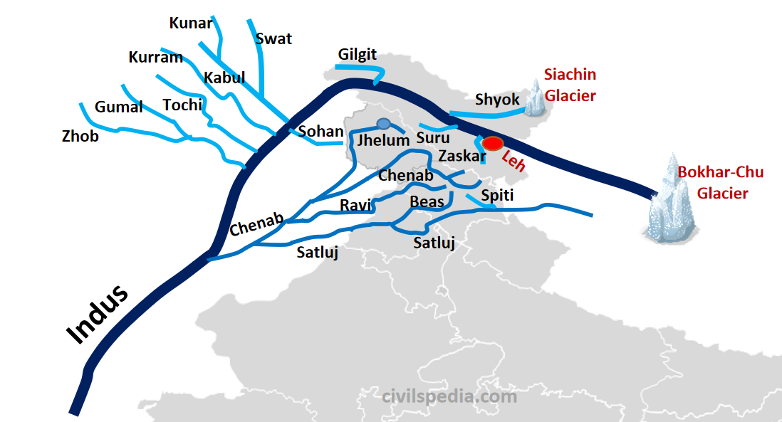
- Indus, along with its tributaries, forms one of the largest drainage systems in the world. It is from this river that India got her name.
- River Indus originates at Bokhar-Chu Glacier of Tibet.
- In Tibet, Indus is known as ‘Singhi Khamban’ or Mouth of Lion.
Indus in India
- It enters India and continues to flow in the northwest direction between the Ladakh and the Zaskar Ranges. Here it encircles the town of Leh and is joined by the Zaskar River. Later, Suru (an obsequent tributary on which Kargil lies) joins the Indus. Subsequently, it is joined by the Shyok (origin: Siachin Glacier). Gilgit is the last tributary of the Indus in India.
Indus in Pakistan
- Near Attock, it takes a sharp southerly bend and ends its mountainous journey after passing through a deep gorge. Here it is joined by the Kabul River from Afghanistan.
- After that, it flows through the Potwar Plain and crosses Salt Ranges. Some important tributaries like Kurram, Tochi, Sohan and the Zhob-Gomal join the Indus River here.
- Indus joins Panjnad (in Punjabi) or Punchnad (in Hindi), i.e. accumulated waters of the five eastern tributaries- Jhelum, Chenab, Ravi, Beas and Satluj near Mithankot, about 805 km from the sea.
- After forming a big delta, Indus finally empties itself into the Arabian Sea, south of Karachi.
Main Tributaries of Indus
The 5 main tributaries of the Indus are big rivers in themselves and deserve a brief mention here. These rivers join together one by one before they ultimately meet the main river.
1. Jhelum
Origin
- Verinag in Pir Panjal Range
Length
- 724 Km
Other Names
- Vitasta (Ancient/ Vedic Name)
- Neelam (in Pakistan)
Flow
- Initially, it flows northwards till Wular Lake and further in the southwest direction to flow through the Kashmir Valley.
- At Muzaffarabad, Jhelum joins Kishenganga and takes a sharp hairpin southward swing.
- After that, it forms a border between India and Pakistan for 170 km and emerges at Potwar Plateau at Mirpur.
- Finally, it joins Chenab at Trimmu.
2. Chenab
Origin
- Near Bara Lacha Pass
Length
- 1,180 Km
Other names
- Askini (Vedic name)
- Chandrabhaga (in Himachal Pradesh)
Important points
- It is the Indus River System’s largest tributary.
Flow
- Two small streams on opposite sides of the pass, namely Chandra and Bhaga, combine to form Chandrabhaga. Chandrabhaga flows in the northwest direction and enters Jammu and Kashmir as Chenab after cutting a deep gorge.
- After passing through Kashmir, the river enters Pakistani Punjab.
- Later, it joins Jhelum and Ravi and finally meets Satluj to form Panchnad.
Projects on the river
- Projects on Chenab include Salal, Baglihara and Dulhasti Projects.
3. Ravi
Origin
- Kullu Hills near Rohtang Pass (Himachal Pradesh).
Length
- 725 km
Other Names
- Purushini (Vedic name)
Flow
- Initially, it flows in a northwest direction.
- After crossing Chamba, it takes a south-westerly turn and leaves the Dhaula Dhar range making a deep gorge.
- It enters Punjab at Madhopur, and after passing through Punjab, it enters Pakistan 26 km south of Amritsar.
- In Pakistan, Lahore is situated on its banks. Harappa is also situated on the banks of Ravi.
- It meets Chenab near Rangpur in Pakistani Punjab.
Projects on the river
- Ranjit Sagar, Chamera and Baira Siul.
4. Beas
Origin
- Beas Kund near Rohtang Pass at the southern end of Pirpanjal (Himachal Pradesh)
Other Names
- Vipasa (Vedic name)
Length
- 465km
Flow
- It originates near Rohtang Pass near the source of Ravi.
- It enters Punjab forming a deep gorge from Lorji to Talwara. From here, it takes a deep south turn to enter the plains.
- Finally, it joins Satluj at Harike (Ramsar Wetland).
Projects on the river
- Pong Dam & Pandoh Dam
5. Satluj
Origin
- Rakas Lake near Mansarovar; enters India through Shipki la pass.
Other Names
- Satudri (Vedic name)
- Langchen Khambab (Tibetan name)
Length
- 1050 km (in India)
Important Point
- It is an antecedent river
Flow
- After originating near Mansarovar, it flows through Tibet and enters India at Shipki La Pass, forming a deep gorge.
- In Himachal, it joins a number of small tributaries. The most important among these is Spiti.
- It enters the Punjab plains after forming a gorge at Naina Devi, where the famous Bhakra Dam has been constructed.
- At Ropar, it turns westwards and meets Beas at Harike. Further, it keeps on flowing westward and forms a boundary between India and Pakistan at Ferozepur.
- In Pakistan, it meets Chenab. The combined waters of the five rivers of Punjab thus formed is known as Panchnad.
- Panchnad meets Indus at Mithankot.
Projects on the river
- Bhakra Project and Naphtha Jhakhri
Indus Water Treaty
- After partition, Indus Water Sharing Treaty was signed in 1960 between India & Pakistan (under the aegis of the World Bank).
- Pakistan was given: Indus, Jhelum & Chenab.
- India was given: Ravi, Beas & Sutlej.
- India is permitted limited use on rivers granted to Pakistan, such as drinking water, existing agriculture use, limited expansion, storage of no more than 3.6 MAF (million-acre feet), and hydroelectricity generation through run-of-the-river projects.
- But the condition is India can’t divert the water of these rivers.
- This treaty is hailed as one of the most significant diplomatic achievements of both nations because water sharing is a very sensitive issue, and no other Asian Nation has been able to sign such a treaty.
(For more details – CLICK HERE)
Ghaggar
- Ghaggar rises from Talus fans of Shivalik in Sirmaur near Ambala.
- After entering the plains, it disappears & again reappears at Karnal. Further on stream is called Hakra, which gets lost in the Hanumangarh district.
- The considerably large size of this river bed, i.e. 5 to 8 km wide with loamy soil in the river bed led to the belief that in old times Satluj might have flowed south to join Ghaggar- Hakra & this was a much bigger river known as Saraswati in Vedic literature.
Perfect image of the map because one picture cover all the tributary which make easy to understand this river system
Thanks for such a kind review. Please share this platform with others as well.Thanks for such a kind review. Please share this platform with others as well.
This site is just amazing, the content properly arranged and the refreshing original images and to the point content as per the syllabus, Appreciate your efforts team/admin. Thanks a ton!
how amazingly you people have explained it, and also what a diagram.
Thank you. Spread the word.
I am preparing for CBSE Superintendent Tier2. These notes are very helpful (crisp and to the point). I was searching for content and I found this beautiful website. Thank you civilspedia team for the content and I highly appreciate your work.
Thank you. Spread the word.