Table of Contents
Humidity, Condensation, Clouds and Precipitation
This article deals with ‘Humidity, Condensation, Clouds and Precipitation’ This is part of our series on ‘Geography’ which is important pillar of GS-1 syllabus . For more articles , you can click here
Humidity
- Water vapour present in the air is known as humidity.
- It is expressed quantitatively in different ways like
| Actual Humidity | Actual amount of the water vapour present in the atmosphere. |
| Relative Humidity | The ability of the air to hold water vapour depends entirely on its temperature. The percentage of moisture present in the atmosphere as compared to its full capacity at a given temperature is known as the relative humidity . |
| Specific Humidity | Ratio of weight of water vapour to weight of dry air. |
| Vapour pressure | Part of barometric pressure that is caused by water vapour alone. |
- The air containing moisture to its full capacity at a given temperature is said to be saturated. It means that the air at the given temperature is incapable of holding any additional amount of moisture at that stage.
- The temperature at which saturation occurs in a given sample of air is known as dew point.
Evaporation & Condensation
1 . Evaporation
- Evaporation is a process by which water is transformed from liquid to gaseous state.
- It can occur in three
conditions
- High temperature
- Low Pressure conditions
- Fast moving wind
2. Condensation
- Condensation is process of conversion of water vapours present in air into water droplets .
- Condensation is caused by the loss of heat. When moist air is cooled, it may reach a level when its capacity to hold water vapour ceases. Then, the excess water vapour condenses into liquid form.
- Condensation takes place:
- When the temperature of the air is reduced to dew point or When moisture is added to the air
- Surface : Which may be natural like grass etc (making dew) or Hygroscopic Surface/ Nuclei
3. Sublimation
- If water vapour directly condenses into solid form, it is known as sublimation.
Dew, frost, fog and clouds
After condensation, the water vapour or the moisture in the atmosphere takes one of the following forms — dew, frost, fog and clouds.
1 . Dew
- When the moisture is deposited in the form of water droplets on cooler surfaces of solid objects such as stones, grass blades and plant leaves, it is known as dew.
- The ideal conditions for its formation are calm air, high relative humidity, and cold and long nights.
- For the formation of dew, it is necessary that the dew point is above the freezing point (otherwise frost will form) .
2. Frost
- Frost forms on cold surfaces when condensation takes place below freezing point (0 C).
3. Fog
- When temperature of an air mass containing a large quantity of water vapour falls all of a sudden below dew point, condensation happens and subsequent cloud is formed at ground level. This is known as fog.
- Fogs are mini clouds in which condensation takes place around nuclei provided by the dust, smoke, and the salt particles.
| Radiation fog | – Associated with temperature inversion & formed at cold night when temperature of air near ground falls below dew point . – Most common type in winter season. |
| Frontal fog | – When cold air masses converge against warm humid air masses , cold air being heavy remains at bottom while warm air is pushed over leading to cooling & formation of fog – Famous fog of Newfoundland is formed like this. |
- In fog, visibility is less than 1 km.
4. Smog
- Fog + Smoke = Smog.
- In urban and industrial centres, smoke provides plenty of nuclei which help in the formation of fog . Such a condition when fog is mixed with smoke, is described as smog.
- It is associated with very low visibility and health hazard.
There are two type of Smog
a . Sulphurous Smog
- Aka London Smog
- Results from high concentration of Sulphur Oxides in the air caused by use of Sulphur containing fossil fuels , particularly Coal .
- Occur in cool humid climate
- Chemically reducing hence called reducing smog
- Characterised by blue coloured skies aka blue haze.
b. Photochemical Smog
- Occurs in warm, dry & sunny climate
- Results from the action of sunlight on unsaturated Hydrocarbons & oxides of Nitrogen produced from factories and automobiles.
- Chemically Oxidising and hence called Oxidising Smog
- Ozone, PAN (Peroxyacetyl Nitrate), Acrolein & Formaldehyde are produced in it which can cause serious health problems .
5. Mist
- The only difference between the mist and fog is that mist contains more moisture than the fog.
- In mist, each nuclei contains a thicker layer of moisture.
- Mists are frequent over mountains as the rising warm air up the slopes meets a cold surface.
- Visibility is more than 1 Km but less than 2 km.
Visibility Comparison : Mist > Haze > Fog > Smog.
6. Cloud
- Cloud is a mass of minute water droplets formed by the condensation of the water vapour in free air at considerable elevations.
- As the clouds are formed at some height over the surface of the earth, they take various shapes
Clouds
- Clouds are tiny water droplets suspended in the air formed due to the condensation.
- To understand the nomenclature of Clouds, one must be aware of the meaning of some Latin words.
| Cirrus | Curl of hair/ high . |
| Cumulus | Heap or pile of cotton. |
| Strato | Sheet or layer. |
| Nimbo | Rain. |
| Alto | Middle altitudes. |
Classification of Clouds
The clouds can be classified based on their form, height and appearance as follows:
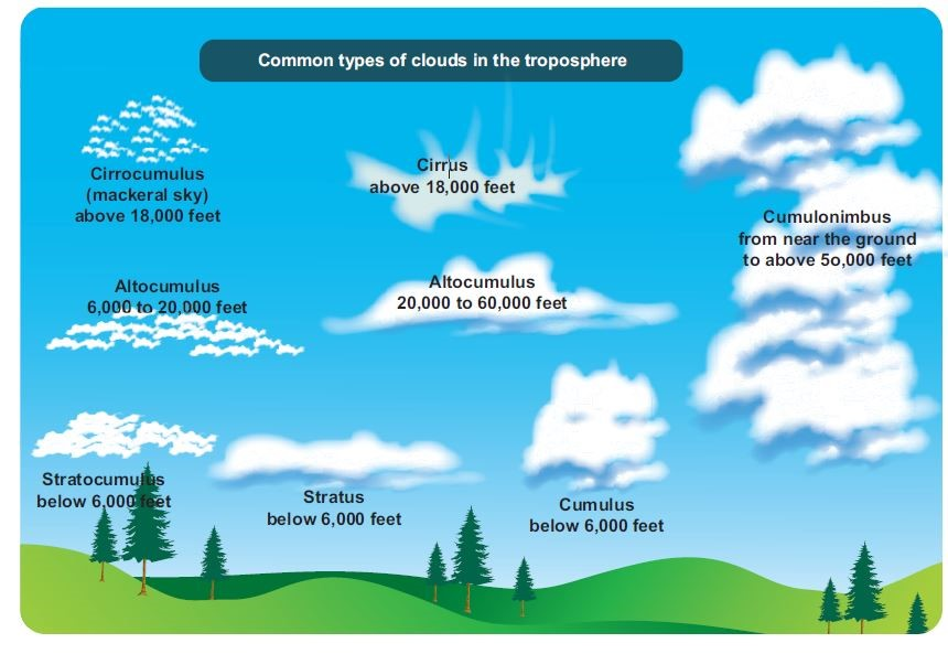
1 . High Clouds
Different types of Cirrus clouds are present above height of 6Km
1.1 Cirrus Clouds
- They look like curl of hair
- It indicates fair weather and gives brilliant sun set.
1.2 Cirro Cumulus
- This appears as white globular masses, forming a mackerel sky.
1.3 Cirro Stratus
- This resembles a thin white sheet. The sky looks milky and the sun and moon shines through this clouds and form a ‘halo’
2. Middle Clouds
Different types of Alto clouds are found between 2 km to 6 km above the ground.
2.1 Altocumulus
- These are woolly, bumpy clouds arranged in layers appearing like waves in the blue sky.
- They indicate fine weather.
2.2 Altostratus
- These are denser and have watery look.
3. Low Clouds
Mainly Stratus or sheet clouds below 2 km height.
3.1 Stratocumulus
- This is rough and bumpy clouds with wavy structure.
3.2 Stratus
- This is very low cloud, uniformly grey and thick, appears like highland fog.
- It brings dull weather and light drizzle. It reduces the visibility and is a hindrance to air transportation.
3.3 Nimbostratus
- This is dark dull cloud, clearly layered, as it brings gentle rain, snow and sleet and it is called as rainy cloud.
4. Clouds with vertical extend
These are mainly cumulus clouds whose height extend from 2 km to 10 km approximately.
4.1 Cumulus
- This is vertical cloud with rounded top and horizontal base, associated with convectional process in the tropical region.
4.2 Cumulonimbus
- This is over grown cumulus cloud with great vertical extent, with black and white globular mass.
- This is formed due to heavy convection in the tropical regions. It is accompanied by lightning, thunder and heavy rainfall
Precipitation
Precipitation is the process by which all forms of water particles fall from the atmosphere and reach the ground.
Conditions necessary for precipitation
- Air parcel must be cooled below dew point.
- Presence of condensation nuclei(i.e. minute hygroscopic particles serving as nuclei for water particles) in the air . Eg salt, smoke & dust particles=> if they aren’t present, precipitation will not occur even if relative humidity is above 100% .
- Condensation must occur rapidly & for fairly long time . If occur for small time , then it may not reach to earth as it would be absorbed by unsaturated air present in lower parts .
Forms of precipitation
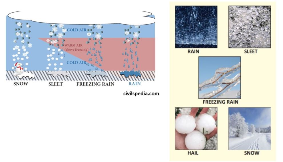
1 . Rainfall
- Most common type of precipitation in temperate & tropical regions.
- When water droplets of more than 0.5 mm diameter falls from the atmosphere to the ground it is called as ‘Rainfall’.
- If the diameter is less than 0.5mm, it is called as ‘Drizzle’.
2. Hail
- When condensed moisture in form of raindrops is carried to great heights by strong convection currents & they get frozen due to low temp at greater heights=> when they come down they gather more water around them & size of pellets become large.
- Ice pellets has size of 5 to 50 mm or some times more.
3. Snowfall
- Precipitation occurs at below freezing point and falls as thin ice flakes or powdery ice, called ‘Snow’.
4. Sleet
- Precipitation in the form of mixture of raindrops & ice pellets less than 5 mm in diameter.
Types of Rainfall
Since rainfall is the major type of precipitation, we will look of type of rainfalls. It can be of various types depending upon process of rising up of air
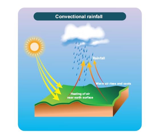
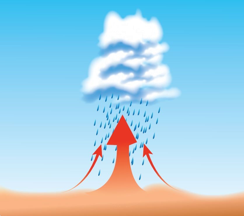
1 . Convectional Rainfall
- As a result of heating of the surface air, the warm moist air expands and is forced to rise to a great height. As the air rises, it cools, reaches dew point and condenses to form clouds.
- Cumulonimbus clouds are formed in this .
- This type of rainfall occurs
- Throughout the year near the equator in the afternoon. It is called as 4 ‘O’ clock rainfall region.
- In middle latitudes, convectional rainfall occurs in early summer in the continental interiors
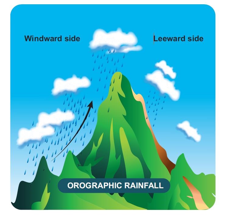
2. Orographic Rainfall
- Air is forced to move up by landform features like mountain, plateau , escarpment etc and air thus rising may cool below dew point causing rain.
- Windward side gets heavy rain whereas leeward side is rain shadow area.
- Most of rain occurring in India and world is orographic . In India, Western coast & North East India gets rainfall by this process.
3. Cyclonic Rainfall
- This type of precipitation is associated with a cyclonic activity (Tropical and Temperate cyclones)
- Cyclonic rainfall is associated with Cumulo-Nimbus clouds. The rainfall is very heavy and accompanied with lightning and thunder and high speed winds which has the potential to cause damage.
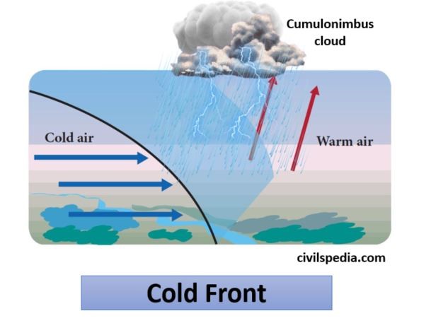
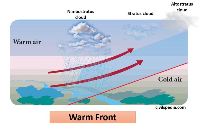
4. Frontal Rainfall
- ‘Frontal rainfall’ is associated with fronts which form due to collision of different air masses.
- It can be of two types
- Warm Air Front Rainfall : In this , warm air invades cold air leading to formation of Nimbostratus clouds and gentle rainfall.
- Cold Air Front Rainfall : In this, cold air invades warm air leading to formation of Cumulonimbus cloud and violent rainfall with lightening.
In visibility comparison, the order should be:
Haze > Mist > Fog > Smog
(Do correct it)
Else everything is great!!
Do include topics:
1) Collision-Coalescence hypothesis
2) Ice-crystal formation hypothesis
3) Cloud burst
4) Cloud seeding