Table of Contents
Wind Systems
This article deals with ‘Wind Systems’ This is part of our series on ‘Geography’ which is important pillar of GS-1 syllabus . For more articles , you can click here
Winds
- Wind is the horizontal movement of air molecules from areas of high pressure to areas of low pressure to maintain the atmospheric equilibrium.
- Nomenclature of Winds
- Winds are named easterly, westerly, northerly etc on basis of direction of their origin.
- Easterly wind is that which originate in east & blow from east to west.
- Wind direction is identified by an instrument called Wind Vane and wind speed is measured by Anemometer.
Factors affecting direction & velocity of wind
1 . Pressure Gradient
- If pressure gradient is more, velocity will be more in magnitude because differences in atmospheric pressure produces a force.
- The wind always moves perpendicular to isobars.
2. Frictional Force
- Lower is frictional force, greater will be the speed .
- Over the sea surface the friction is minimal.
3. Coriolis Force
- If the earth did not rotate, the winds would blow in a straight path. Then the rotation of the earth results in Coriolis effect and it deflects the direction of the wind.
| Northern Hemisphere | Deflect towards Right or Clockwise (NCR) |
| Southern Hemisphere | Towards Left or Anticlockwise. |
- Coriolis force is directly proportional to the angle of latitude. It is maximum at the poles and is absent at the equator.
Type of Winds
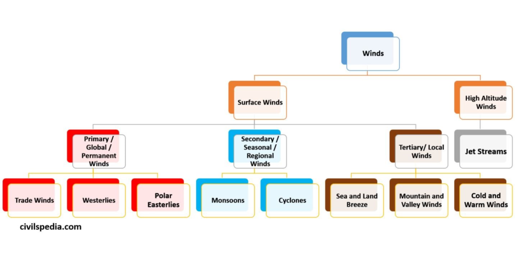
1 . Primary / Global/ Permanent Winds
Pressure belts lead to the formation of primary wind system resulting in Trade Winds, Westerlies and Polar Easterlies
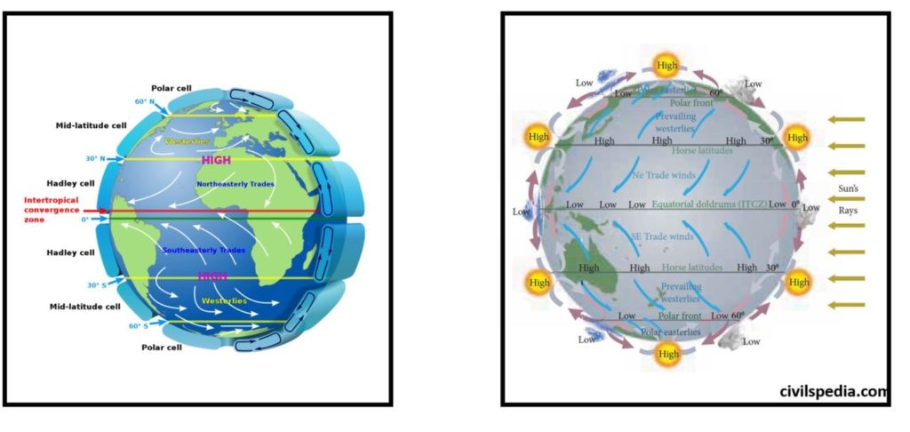
1.1 Trade Winds
- The winds blow from the sub tropical high pressure belt towards the equatorial low pressure belt.
- Due to Coriolis Effect, these winds are deflected to the right in the northern hemisphere and to the left in the southern hemisphere.
- As winds are named after the direction from which they originate they are called as the North East and South east trade winds.
- As the winds favoured trading ships they are called as ‘Trade winds’.
Side Topic : Tropic Deserts & Trade Winds (aka Trade Wind Deserts or Trade Deserts)
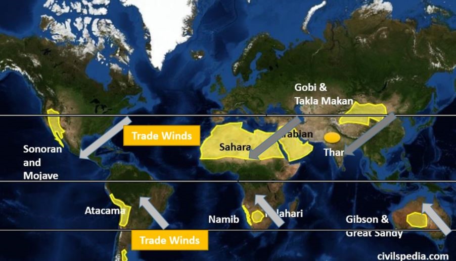
- Tropical easterlies/ Trade Winds flow from east to west . Hence, windx becomes dry when they reaches the western coast of continent as all the moisture is already shed in form of rainfall on eastern coast .As a result, in tropical region, deserts are found on western coasts of continents .They are also known as Trade Deserts.
- Apart from that, Cold Currents near the western coasts of continents also provides desiccating imapct on the surrounding lands leading to more dryness .
1.2 Westerlies
- Westerlies flow towards the Sub Polar High from Sub-Tropic Low
- They turn towards right and left in northern and southern hemisphere respectively due to Coriolis force.
- As they flow from West to East, they are called Westerlies
- Ocean is dominant in the southern hemisphere between the latitudes 40º and 60ºS. Hence the westerlies are so powerful and persistent that the sailors used such expressions as “Roaring Forties”, “Furious Fifties” and “Screeching Sixties” for these high velocity winds in the latitudes of 40º, 50º and 60º respectively.
1.3 Polar Easterlies
- Polar Easterlies flow towards the Sub Polar High from Polar High .
- They turn towards right and left in northern and southern hemisphere respectively due to Coriolis force.
- As they flow from East to West, they are called Easterlies
2 . Secondary / Regional / Seasonal Winds
Monsoon and Cyclones are considered to be Secondary or Seasonal Wind
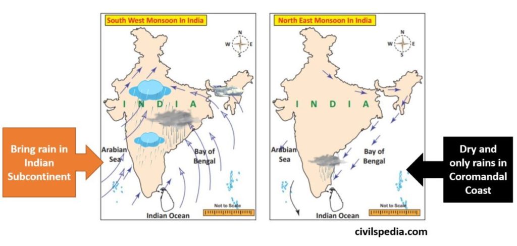
2.1 Monsoons
- Monsoons are seasonal winds which reverse their direction due to various reasons .
- These winds bring rainfall in India and are the major climatic feature of climate of Indian Sub-continent.
- We will detail with these winds in Indian Climate .
2.2 Cyclones
- Wind blowing in circular manner around an area of low pressure
- Due to Coriolis effect – blow in anticlockwise direction in Northern hemisphere & clockwise direction in southern hemisphere.
- Cyclones are of two types.
| Tropical cyclones | Develop over oceans in summers in tropical regions . Eg : in Bay of Bengal, China sea , Caribbean sea etc. |
| Temperate / Extra tropical | Develop in middle latitudes in winter season |
More about cyclones in separate article
3. Tertiary / Local Winds
Tertiary winds are formed due to pressure gradients which may develop on a local scale because of differences in the heating and cooling of the earth’s surface.
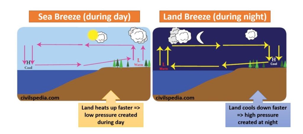
3.1 Sea and Land Breezes
- Sea Breeze : During daytime, land heats up much faster than water. The air over the land warms and expands leading to formation of low pressure. At the same time, the air over the ocean remains cool because of water’s slower rate of heating and results in formation of high pressure. Air begins to blow from high pressure over ocean to the low pressure over the land. This is called as ‘Sea breeze’.
- Land Breeze : During night time, the wind blows from land to sea and it is called as ‘Land breeze’
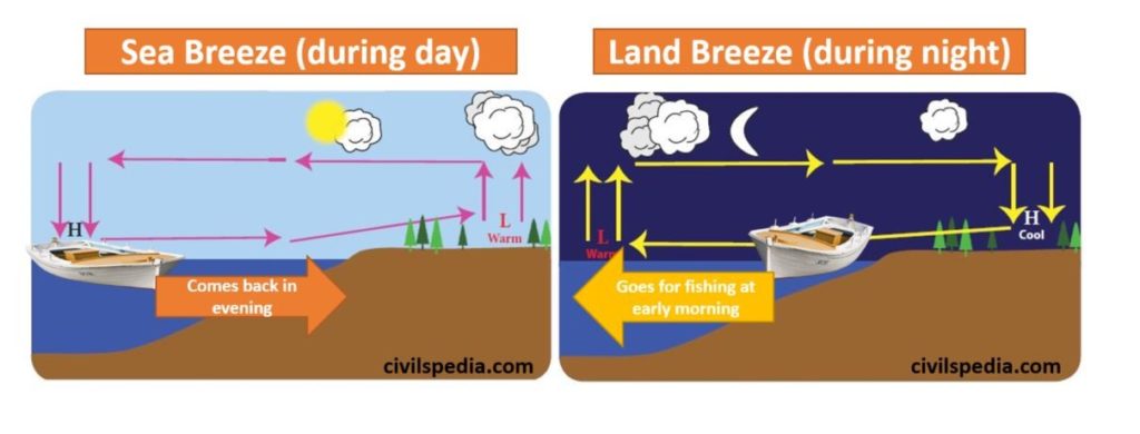
Note : Sea breeze and land breeze influence the movement of boats near the coastal region and fisher men use these winds for their daily fish catching. Fishermen go for fishing at early morning along the land breeze and return to the shore in the evening with the sea breeze.
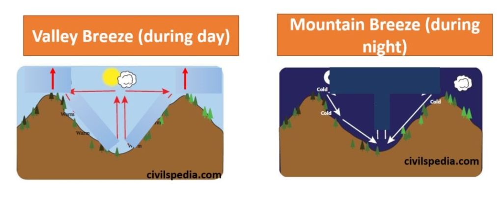
3.2 Mountain and Valley Breezes
- Valley Breeze / Anabatic Winds : During the day, mountain hillslopes are heated intensely by the Sun, causing the air to expand and rise. This draws in air from the valley below, creating a valley breeze.
- Mountain Breeze / Katabatic Winds : During the night the hillslopes get cooled and the dense air descends into the valley as the mountain wind
3.3 Warm and Cold Local Winds
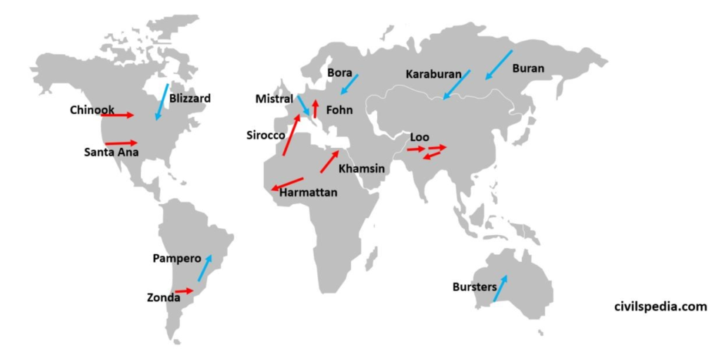
Cold Local Winds
- High Pressure conditions are created in areas situated in high latitudes due to cold weather. As a result, air starts to come down and diverge into different directions (forming anti-cyclones) blowing as ‘Cold and Dry Local Winds’ and reducing temperature of surrounding regions as well.
- In Siberia such anti cyclonic winds are created and diverge in different directions . These winds are called Buran
| Buran | Explained above |
| Mistral (Europe) | Cold northerly from central France and the Alps to Mediterranean |
| Bora (Eastern Europe) | North easterly wind from eastern Europe to north eastern Italy |
| Blizzard (USA & Canada) | Cold and dry snowy winds blowing in USA and Canada |
| Pampero (Argentina) | Cold and dry wind blowing in Pampas of Argentina |
| Southern Bursters | Cold and dry wind blowing in Australia |
Warm Local Winds
- Low pressure develops over Deserts and low latitudes in summers due to excessive heating of land . The air starts to move upward and diverges in different directions blowing as upper tropospheric wind. They carry sand and dust with them and raises temperature of regions over which they flow. These winds are known with different names in different regions like
| Loo | India (Punjab, Haryana, Rajasthan, UP, Delhi etc) |
| Sirocco | From Sahara desert to Italy and Spain after crossing Mediterranean Sea |
| Khamsin | Egypt |
| Harmattan | From Sahara desert to Gulf of Guinea |
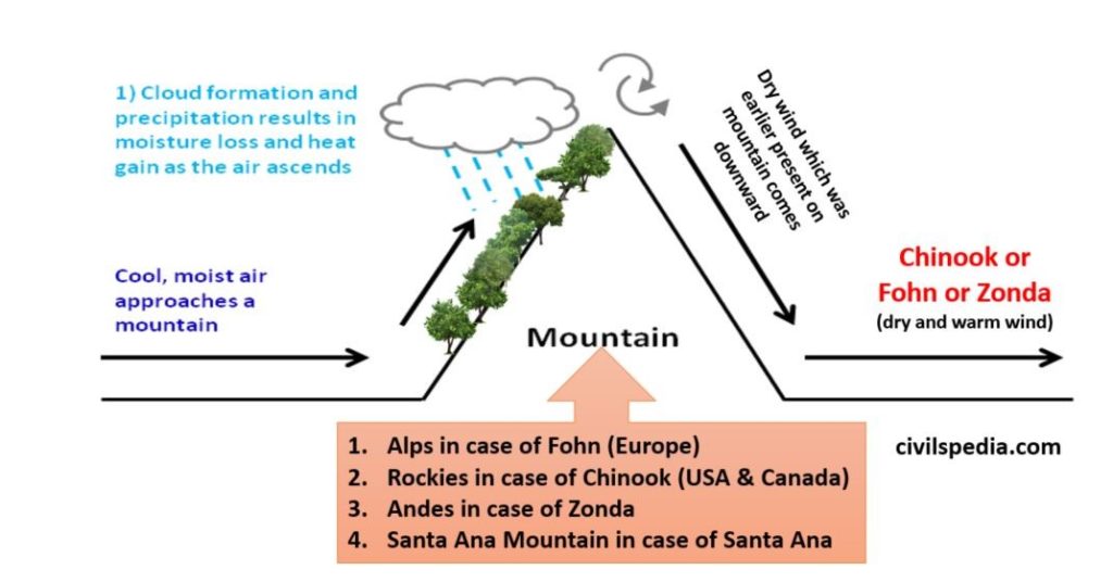
- Other type of warm and local winds like Chinook winds develop when warm, moist air blows from the adjoining ocean ( Pacific Ocean in this case) towards the Mountain range situated near the coast (Rockies in this case). In such situation, dry and warm air over the mountain will descend in the adjoining valley on the leeward side of wind . Other such type of winds are Fohn and Zonda
| Chinook | US and Canada | Rockies |
| Fohn | Europe | Alps |
| Zonda | Argentina & Uruguay | Andes |
| Santa Ana | California | Santa Ana Mountains |
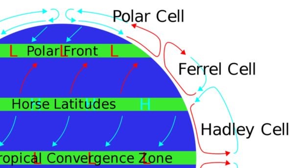
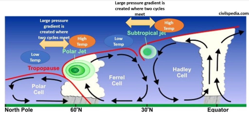
Upper Atmospheric / Meridional Circulations
| Hadley cycle | Air from equator being lighter move up & diverges toward poles & descends at subtropical areas causing higher pressure there. That wind is again carried by trade winds to equator. |
| Ferrel Cycle | Same thing between subtropical & subpolar pressure belts |
| Polar cell | Between polar & subpolar pressure belts |
Side Topic : Upper Tropospheric Winds and Geostrophic Winds
To understand formation of Jetstreams, it is important to know what are Geostrophic winds.
- Unlike air moving close to the surface, an air parcel in the upper troposphere moves without a friction force because it is so far from the source of friction—the surface. So, there are only two forces on the air parcel, the pressure gradient force and the Coriolis force.
- A useful heuristic (i.e. theoretical model) is to imagine that air parcel in the upper troposphere is starting from rest under the influence of ‘Pressure Gradient Force ” moving from point of High Pressure to Low Pressure .
- Due to pressure gradient force and absence of friction force , speed of wind will keep on increasing . Since, Coriolis force increases with increase in speed and acts perpendicular to Pressure Gradient Force, situation will be reached when Pressure Gradient Force equals Coriolis Force & these winds will deflect 90° (clockwise) . At this point, the flow is no longer from high to low pressure, but parallel to the isobars. Such winds are called Geostrophic winds
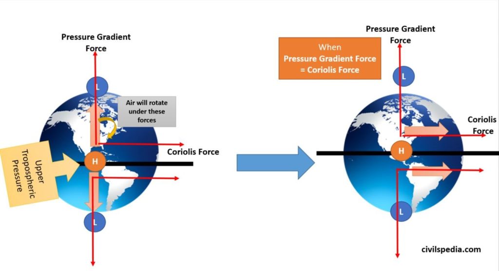
- These are also known as Upper Tropospheric Westerlies
- Jetstreams are an example of Geostrophic winds .
Direction of Geo Strophic winds
Always move from WEST TO EAST (hence called Westerlies)
| Northern Hemisphere | – Geostrophic winds deflect clockwise . – Move from West to East. |
| Southern Hemisphere | – Geostrophic winds deflect Anti Clockwise. – Move from West to East. |
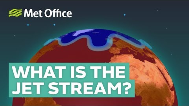
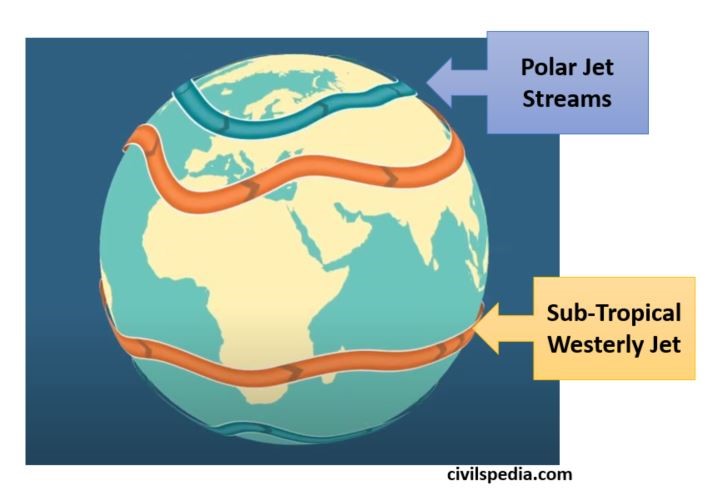
Jetstreams
- Jet streams are special type of Geostrophic winds .
- These are strong and narrow bands of meandering wind blowing at height of 6 to 14 km ( just below Tropopause) at very high speed of upto 450 Km/hr. They occur at points where atmospheric pressure gradients are strong and friction force acting on moving air is absent.
- Jetstreams flow in wavy fashion and create alternate High Pressure & Low Pressure zones .
Location of Jet Streams
- They aren’t found arbitrarily . They are situated at typical positions like where two Meridional Circulations meet. (Reason : Point where two air masses of different temperatures meet, the resulting pressure difference is highest. Only in such condition, Pressure Gradient Force can increase the speed of wind to such an extend that Coriolis Force can balance the Pressure Gradient Force and rotate it by 90°) (I know it is hard to understand. To properly understand what is happening, you can refer this useful video What is the jet stream and how does it affect the weather?)
- Hence , 4 permanent Jet streams are always found .
| 2 Polar Jet | Between Polar cell & Ferrel cell. |
| 2 Sub Tropical Westerly Jet (STWJ) | Between Ferrel cell & Hadley cell. |
Apart from that, there are some temporary Jet-streams like
- Tropical Easterly Jetstream
- Somali Jetstream
Speed of Jetstreams
- Cause of Jetstreams is the pressure difference (due to temperature difference) in the upper atmosphere. Hence , higher the pressure gradient (or temperature gradient) higher will be speed of Jetstream.
- Temperature variations are more in winters (lowest ~ -70 C & highest ~ 15 C) compared to summers (lowest ~ 20 C & highest ~ 55 C) . Hence, Jetstreams are faster in winters of the respective hemisphere.
Importance of Jetstreams
1 . Sub Tropical Westerly Jet Stream (STWJ) & Indian Weather
- It is centred around 25° N & S at altitude of 12 km & is strong in winter season with velocity of 40 mph.
- It greatly determines
the weather of Indian Sub continent .
- During summer until it is present over Indian subcontinent , High Pressure is maintained over there & monsoon can’t start. Only when STWJ moves above Himalayas & low pressure is created over Indian subcontinent , monsoon hits India.
- Western Disturbances : STWJ comes to India after passing over Mediterranean Sea where rainfall occurs during winter. STWJ bring those cyclonic disturbances to north India along with it. This results in winter rain & hailstorms in North India & occasional high snowfall in hilly areas .
2. Jetstreams and Frontal / Temperate Cyclones
- Jetstreams play important role in formation of Temperate Cyclones which are important feature of the climate of temperate regions like Britain etc .
3. Tropical Easterly Jet and Somali Jetstream
- These Jetstreams play important role in the Indian Monsoon.
- More about this can be read in (chapter) Indian Climate .
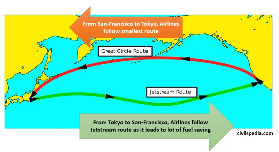
4. Role in Aviation Industry
- If aeroplanes moves in the direction of Jetstream, it can lead to large fuel savings and vice-versa
Impact of Climate Change on Jetstreams
Due to Climate change and Global warming, Earth’s Polar regions are warming more rapidly than other parts . This has resulted in weakening of Polar Jet Streams because temperature contrast that drives Jetstreams has decreased.
Thank you so very much! I am a high school Geography teacher in South Africa. This page has been very helpful! The text is simple to understand for my students and the diagrams are clear and applicable.
Thank you!
Welcome. It is great to know that a Geography teacher has found our article helpful.
Excellent notes! It really helps to revise things at a quick pace.
Thank you so much!
thank you so much for your efforts
Thanks for the kind review.