Table of Contents
Monsoon Theories
This article deals with ‘Monsoon Theories.’ This is part of our series on ‘Geography’, which is an important pillar of the GS-1 syllabus. For more articles, you can click here.
Introduction
- The Monsoon is traditionally defined as the seasonal reversal of winds and related changes in precipitation. Monsoon is a surface wind that blows in a particular direction in one season but reverses completely in the other season.
- Monsoon is the main characteristic of the Indian Climate and requires special study. Hence, we will study that in detail.
Monsoon Theories
Monsoons are a complex meteorological phenomenon. Meteorologists have proposed numerous theories explaining the origin of monsoons.
1. Halley’s Thermal Theory
Mechanism of summer Monsoon
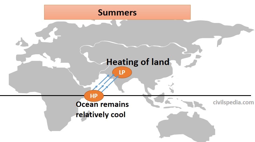
- During summer, interior parts of the North Indian Plains covering Rajasthan, Punjab, Haryana etc., are heated strongly. As a result, low pressure develops, resulting in the formation of the monsoonal trough.
- Temperature over the Indian Ocean is still low. Hence, high pressure prevails over the Indian Ocean.
- Hence, the general movement of air in JUNE is from the South-West (Indian ocean) to North-East (Indian Subcontinent) (this direction is directly opposite to trade winds prevailing during Winter).
- When these moist winds from the Indian Ocean pass over Indian Subcontinent, they cause widespread Monsoon from June to September.
Winter Monsoon
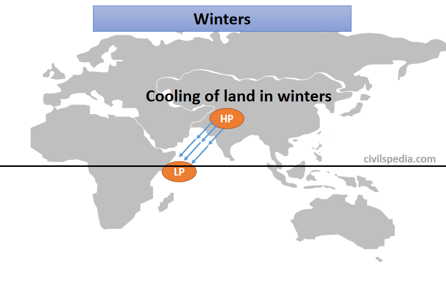
- During Winter, high pressure is developed over land, whereas low pressure prevails over oceans. Hence, winds start to blow from North-East towards South-West (North East Trade Winds).
- These are dry & cold winds causing no rainfall except on the Coromandal Coast, where it gathers moisture after passing over the Bay of Bengal.
Shortfalls
- But this presents a very simple picture and fails to explain the following:-
- Why low-pressure areas on land are not stationary & suddenly change their location?
- Why are there no anti-monsoon circulations in the upper-troposphere which must be there if they were thermally induced?
- Low pressure in Northern India develops in April & May, but rain starts there in June. Why??
- Monsoon rains are an amalgamation of convectional, orographic & cyclonic rainfall & the thermal concept fails to explain this.
2. Fohn Dynamic Concept of Monsoon
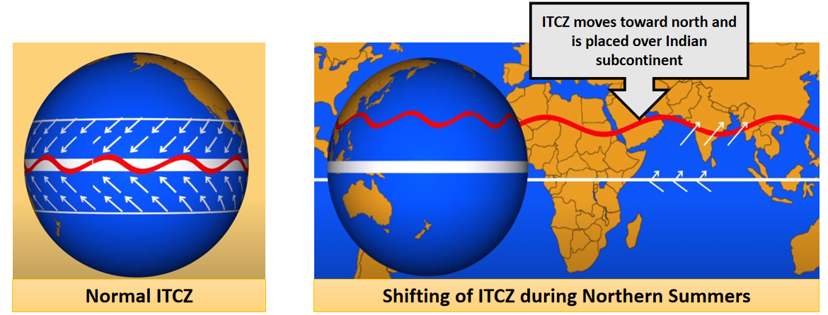
- Fohn tried to explain the monsoons using shifting of ITCZ (Inter-Tropical Convergence Zone), i.e., where northern and southern Trade winds converge. This ITCZ zone keeps shifting towards the north and south according to the apparent movement of the sun.
- According to this theory, Monsoon is the result of the seasonal migration of planetary winds & pressure belts around the Equator due to the apparent shifting of the sun during different seasons
- During Summer, the sun moves directly above the Tropic of Cancer due to the apparent northward movement of the sun. As a result, all the pressure belts of the globe shift northwards. ITCZ moves up to 25° N & low pressure develops over the whole Indian Subcontinent. Trade winds blowing towards ITCZ need to pass through the Equator to reach ITCZ. Due to the Coriolis effect, while crossing the Equator, these winds get deflected and take the southwest direction, becoming a southwest Monsoon. Indian landmass gets rain due to these South-West winds as these winds carry moisture from the Indian Ocean to Indian Subcontinent.
- During Winter, due to the apparent southward movement of the sun, all the pressure belts shift southwards. As a result, ITCZ moves southwards out of India, establishing the North-East Monsoon. Hence, during Winter, winds in India start to blow from North East to South West, creating a North-East monsoon.
3. Real Mechanism
But in reality, the mechanism is more complex than what even Fohn proposed. A large number of factors impact the Indian Monsoon & the exact mechanism is not known to date. Major factors which impact the Indian Monsoon are
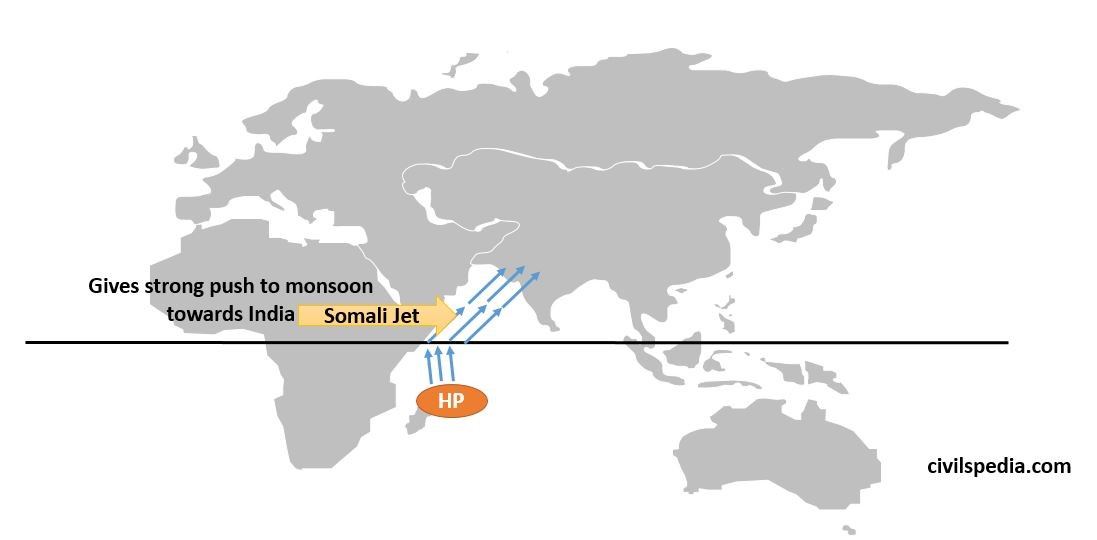
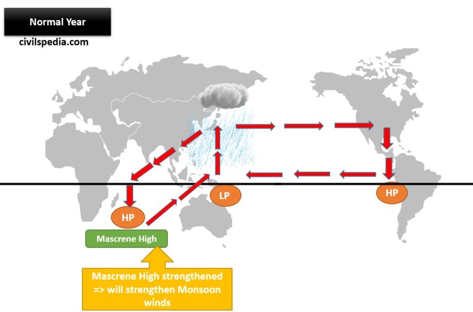
3.1 Maskarenes High
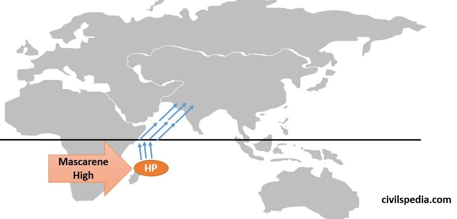
- When there are summers in the North Hemisphere, there are winters in the Southern Hemisphere. As a result, a High-pressure zone develops near a small island in the Southern Hemisphere in the South Indian Ocean called Mascarene. Winds from this high-pressure area, termed as Mascarene High by scientists, start blowing towards low-pressure areas in the Northern Hemisphere, along the east Somalia coast.
- The strength of Mascarene High is a crucial factor in determining the intensity of the Monsoon in India. Stronger is the Mascarene High, stronger will be the push caused by them and stronger will be the rainfall over Indian Subcontinent.
3.2 Somali Jet / Findlater’s Jet
- The monsoon wind that is deflected to the east as it crosses the Equator (due to Coriolis Force) is further deflected to the east by the mountains of Africa on the Somalian Coast and Somali Jet. The Somali Jet transits Kenya and Somalia and exits the African coast at 9 degrees north at a low altitude at very high speed.
- Hence, it gives a strong push to the Monsoon winds & also deflects them towards India.
(This Jetstream was discovered by J. Findlater, a British meteorologist & it is most pronounced between 1.0 and 1.5 km above the ground.)
3.3 Tropical Easterly Jet / Role of Tibet Plateau
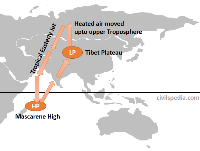
- The first instance of the relationship between the Indian Monsoon and Tibet plateau came some 130 years ago, when Sir H.F. Blanford, Chief Reporter of the newly-established India Meteorological Department (IMD), noticed more Himalayan snow cover during the preceding Winter resulted in a poor monsoon. Hence, scientists began to study the relationship and reached the following explanation.
- In summer, the apparent movement of the sun is northwards. Due to this, there is intense heating of land in Northern India & Tibet.
- Since the Tibetan plateau is situated at a great height, it receives 2-3° C more insolation, and extreme low pressure develops there. As a result, air from Tibet Plateau rises to the Upper-Troposphere and starts moving towards Mascarene High in the form of a Tropical Easterly Jet. After reaching Mascarene high, it descends & further strengthens the Mascarene High-Pressure Cell.
- More strength of Tropical Easterly Jet means stronger Mascarene High, which further means good rainfall in the Indian Subcontinent.
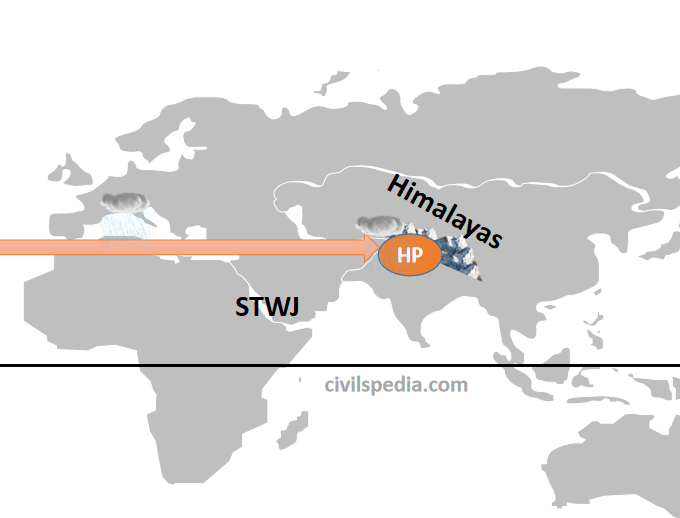
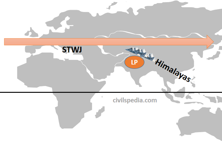
3.4 Sub Tropical Westerly Jet Stream
India is under the influence of Sub-Tropical Westerly Jet (STWJ). It impacts the Monsoon in the following ways
1. Winters
- Due to the sun’s southward apparent movement during winters, all the earth’s pressure belts move southwards. As a result, STWJ also moves southwards & comes over North India (from the Himalayas).
- These Jet streams create High-Pressure Zone over North India, so no rainfall occurs during Winter.
2. Summers
2.1 Early Summer
- With the onset of summers, the sun starts to move northwards; as a result, pressure belts of the earth, along with STWJ, also starts to move northwards.
- During early summers, half of the STWJ is over the Northern plains, while the other half moves north of the Himalayas. Hence, high pressure continues to be maintained over Northern India. Until the whole of STWJ doesn’t move out of North India, Monsoon cant strike Indian Subcontinent.
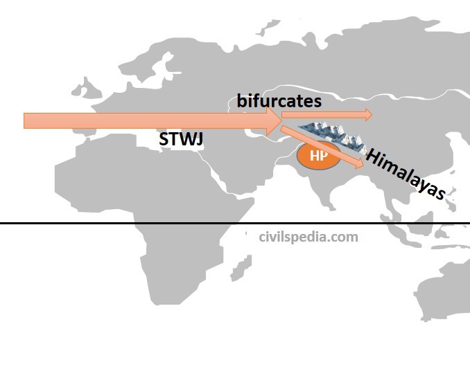
2.2 Late summer, near June
- During late summer, STWJ entirely moves north of the Himalayas, and low pressure develops over North India. Hence, Monsoon strikes Indian Subcontinent in June.
3.5 El Nino
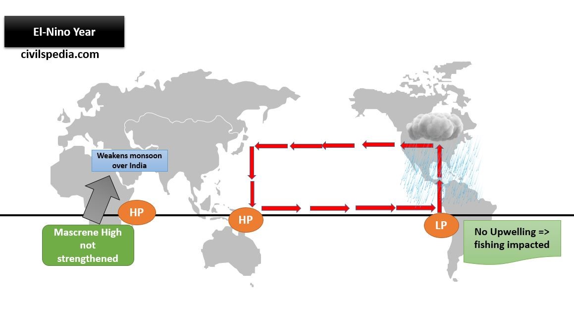
- El Nino creates High Pressure near Northern Australia & as a result, Walker Cell between Western Pacific Pool (WPP) and the Western Indian Ocean (Mascarene High) is altered. In normal conditions, this Walker Cell helps to strengthen the High Pressure in the Western Indian Ocean. But during El Nino, Mascarene High is not strengthened.
- As Mascarene High helps push monsoon winds towards India, in case of weak Mascarene High during El-Nino years, the push would be weaker, resulting in lower rainfall in Indian Subcontinent.
La Nina
- La Niña is the reverse of the El-Nino. Here, extreme Low Pressure prevails over Northern Australia. It strengthens the Mascarene High more than what happens in normal conditions.
- La Niña years are infamous for frequent and intense hurricanes and cyclones in the Atlantic Ocean and the Bay of Bengal, likely due to multiple aiding factors, including high relative moisture and relatively low wind shear over the Bay of Bengal.
3.6 Indian Ocean Dipole (IOD)
- In 1999, N H Saji of Japan’s University of Aizu and others discovered an El-Nino Southern Oscillation (ENSO) -like phenomenon in the Indian Ocean, which they named the Indian Ocean Dipole (IOD).
- The Indian Ocean Dipole (IOD) is defined as the difference in the sea surface temperatures between two poles, i.e. Western pole in the Arabian Sea (western Indian Ocean) and the Eastern pole near Indonesia in the eastern Indian Ocean.
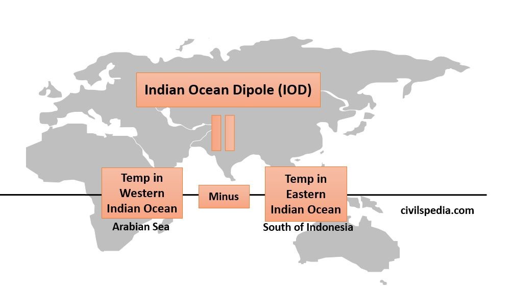
- The IOD affects the climate of Australia, India and other countries surrounding the Indian Ocean and is a significant factor in deciding the rainfall variability in this region.
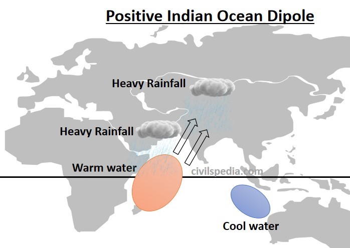
Case 1: Positive IOD
- In this, waters in the Western Indian Ocean (Arabian Sea) become relatively warm compared to waters in the Eastern Indian Ocean (south of Indonesia).
- Studies have shown that a positive IOD year sees more than normal rainfall in central India. It happened in 1994 and 1997.
Point to note: The Indian Ocean Dipole (IOD) and El Nino are independent climatic phenomena but often co-occur. When they co-occur (60% of the time), then two competing factors come into play at the same time i.e.
- El-Nino reduces high pressure at Mascarene high, which negatively impacts the Indian Monsoon.
- But at the same time, positive IOD favours good rainfall over Indian Subcontinent.
This is the reason why we can’t say with certainty that El-Nino will result in lower rainfall over Indian Subcontinent. In 1997, there was intense El-Nino but above-average rainfall in India; in 2002, there was moderate El-Nino but intense drought in India. The reason for this was in 1997, there was a positive IOD which overpowered El-Nino, but in 2002 there was a Negative IOD which exacerbated the impacts of El-Nino.
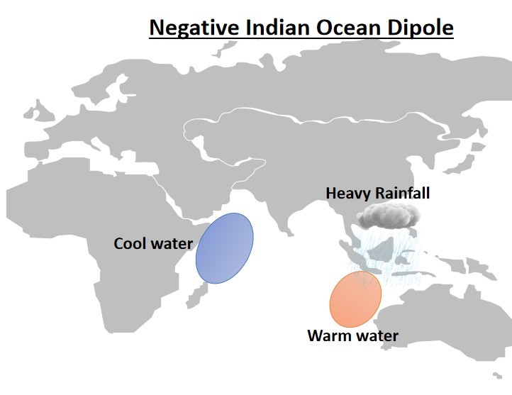
Case 2: Negative IOD
- In this, waters in the Eastern Indian Ocean (south of Indonesia) become relatively warm compared to waters in the Western Indian Ocean (Arabian Sea).
- In this case, more rainfall will happen in southern Indonesia and the eastern Indian Ocean.
Note: Worst drought occurs when El-Nino and Negative or Neutral IOD co-occur.