Table of Contents
Ocean Currents, Waves, Tides and Thermo-Haline Circulations
This article deals with ‘Oceanography: Ocean Currents, Waves, Tides and Thermo-Haline Circulations.’ This is part of our series on ‘Geography’ which is important pillar of GS-1 syllabus . For more articles , you can click here
Introduction
Major movements of ocean water can be categorised as follows:-
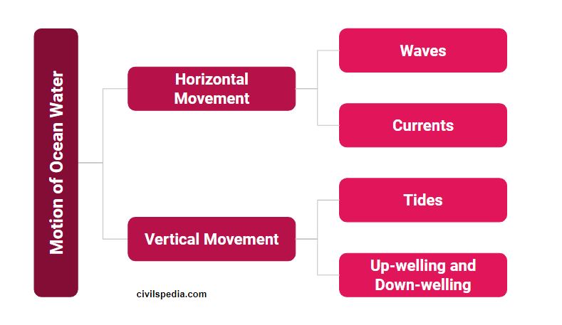
1 . Horizontal Movement : Waves
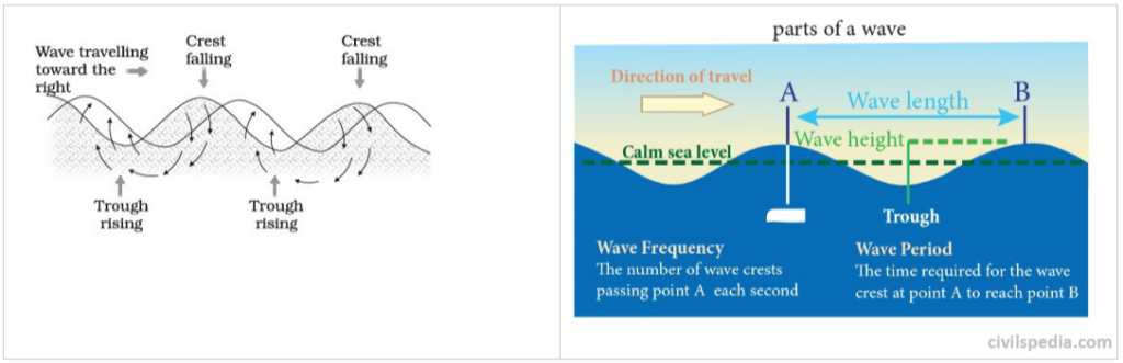
The waves are oscillating movements in the ocean water which transfer energy from place to place.
Creation of waves
- Wind pushes (away) the water body & creates crest.
- Gravity pulls the crest downward & falling water pushes the former troughs upward .
- Actual motion of water beneath wave is circular (& not straight) & while we go downward movement of water molecules keep on decreasing.
- Hence, in waves very slow horizontal movement of water takes place .
Waves actually involves the transfer of energy and water particles don’t move across the sea/ocean as such. Water particles only moves in circular pattern as wave passes. Wind causes waves to travel in ocean and energy is released at the shore.
2 . Horizontal Movement : Currents
- Large mass of moving water from one part of the ocean to another in a definite direction is called as ocean current.
- The movement is produced due to earth’s rotation, temperature difference of ocean water, salinity, density , air pressure and winds.
- They circumnavigate the earth .
What Currents do
- Heat re-distribution – from Equator to Poles.
- warm water from equator to poles .
- cold water from poles to equator.
Factors responsible for ocean current
The primary forces that influence the currents are:–
a. Wind
- Most dominated force.
- In most cases, direction of wind will be direction of underlying current .
b. Insolation
- Heating by solar energy cause the water to expand. That is why, near equator the ocean water is about 8 cm higher in level than in the middle latitudes.
- This causes a very slight gradient and water tends to flow down the slope.
c. Salinity
- Water will move from lower salinity to higher salinity on the surface .
- Reason : Water with higher salinity being denser sinks & as a result water with low salinity comes to fill the space.
- Eg : Water from Atlantic flows to Mediterranean
d. Coriolis Force
Coriolis Effect : Due to rotation of earth – West to East .
- Object moving in Northern Hemisphere will deflect Clockwise
- Object moving in Southern Hemisphere will deflect Anti Clockwise
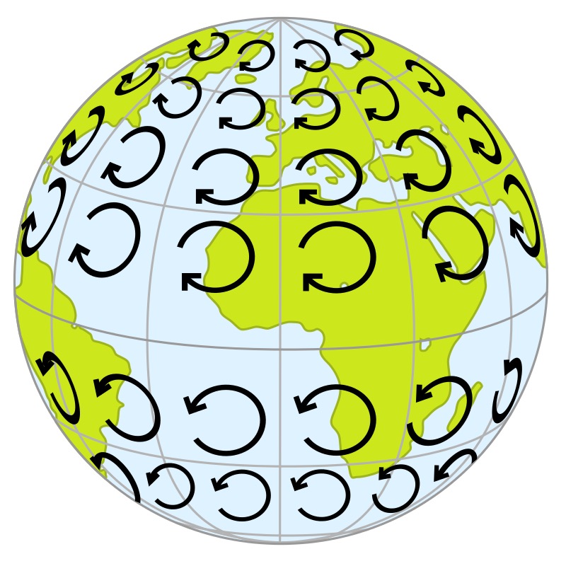
Movement of currents should be straight from equator to pole but not straight because
- Coastline modifies the path.
- Coriolis force
Nomenclature : Warm Current & Cold Current
- Warm current is one that carry water warmer than water found at that latitude .
- Water flowing from low latitude to higher latitude is warm.
Currents effect climate of bordering landmass eg wind blowing to land from warm current cause rainfall. This is the reason why mostly east coasts of continents receive rainfall & west coasts are deserts.
General Pattern of Currents in all Oceans
- Due to rotation of earth from west to east , two currents one on each side of equator are formed called North & South Equatorial Current.
- Water carried in form of Equatorial currents tend to accumulate in western part of ocean or eastern coast of continent.
- To balance this Counter Equatorial Current is formed between two Equatorial Currents from West to East.
- Water at eastern coast of continent start piling up & under influence of density gradient start moving towards middle latitudes
- At same time high density water at poles start flowing towards equator in form of currents along eastern coast of continent & two meet in middle latitudes where cold water sinks & warm water spreads on it .
- The water is pushed towards east by strong westerlies & water reaches eastern part of ocean or western coast of other continent.
- Obstruction at western part of continent divides water & one moves toward pole & other toward equator.
- The water sinked in middle latitude upwells along the western coast to make good removal of water at equator . As a result circulatory cells known as gyres are formed one in each major ocean basin & is situated between 20 to 30 degree in both hemisphere.
- This system is found in all oceans except Indian ocean where major changes occur due to presence of Indian peninsula & seasonal reversal of winds producing double gyre moving in seasonally opposite directions.
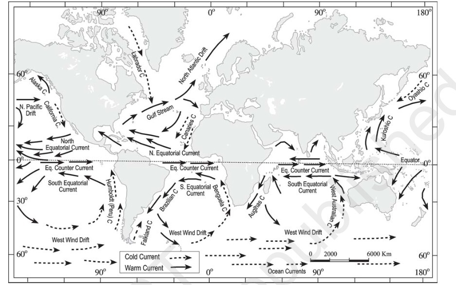
2.1 Currents in Atlantic Ocean
Warm Currents in Atlantic Ocean
a. North Equatorial Current
- North equatorial current flows from east to west between 5– 20 N latitudes.
- After leaving the west coast of Africa, it attains its main characteristics.
- When it reaches the east coast of South America, it splits into two branches and one branch called Antilles current moves along the coast of West Indies and other branch is diverted into the Caribbean sea.
b. South Equatorial current
- It flows south of equator within 0 – 12 S latitude in between the coast of Africa and South America.
- It is stronger than the North equatorial ocean current
c. Gulf Stream
- Gulf Stream starts from the Gulf of Mexico and carries warm waters into the colder latitudes.
- It bends with the coastline up to 40th parallel after which the direction is almost to the east, due to the force and the direction of the westerlies and the deflective force of the earth.
- It joins the Labrador cold current near New Found land, Canada making it a good fishing ground.
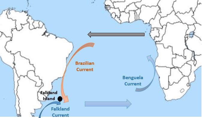
d. Brazil Current
- Warm current moving south along the coast of Brazil.
- It joins the Falkland cold current near Bahia Blanca making it a good fishing ground.
e. Norwegian Current /North Atlantic Drift
- Norwegian Current takes warm water towards the coast of Norway allowing it’s coast to be operational throughout the year.
Cold Currents of Atlantic Ocean
a. Canary Island
- It flows south along the Western coast of North Africa between Maderia and Cape verde
- Gradually , it merges with the North equatorial current.
b. Labrador Current
- In the north Atlantic, it flows from the Baffin Bay and Davis Strait towards south.
- It brings cold waters from polar zone and moves along the coast of green land.
- It meets with warm Gulf Stream near New Found Land making it a good fishing ground.
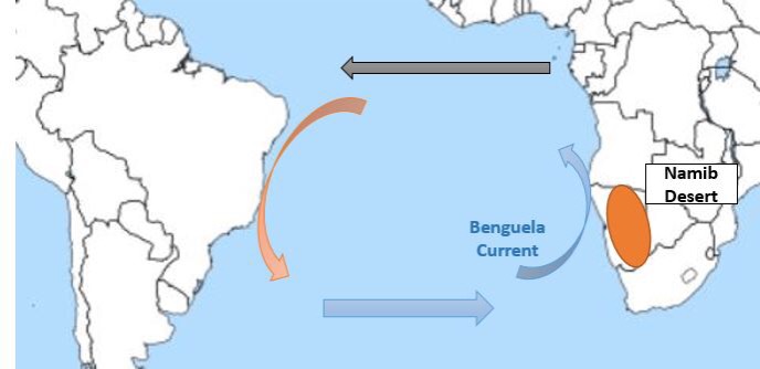
c. Benguela Current
- It flows northward along the western coast of Africa
- It carries cold waters from sub-Antarctica surface water and mixes with south equatorial current
Side note : Newfound Land Island
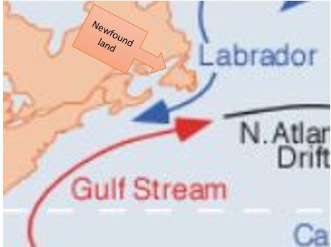
- Meeting point of Gulf Stream( warm current) & Labrador current (cold Current)
- Amount of planktons increases resulting in large number of fishes. Hence, it is Good fishing ground.
Side Note: North Atlantic Drift / Norwegian Current
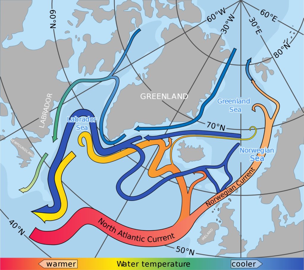
- It provides warming effect to western Europe.
- Due to this, ports of Norway – Narvik, Hammerfest , Murmansk etc keep on operating in winter but at same latitude ports in Russia freeze during winter .
Side Note : Canary Current and Sahara Desert
- Canary current is cold current(passes near Canary Islands).
- They give desiccating effect (drying effect) to Sahara Desert resulting in no rainfall .
Side Note : Sargasso Sea
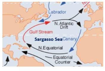
- It is the only sea in the world without a land boundary. Its boundaries are defined only by ocean currents. It is encircled by the Gulf Stream in the west, north Atlantic drift in the north, Canary current in the east and North Equatorial and Antilles current in the south
- Due to confinement , Sargassum ie a sea weed grow in this region which obstructs navigation. Plants have become adapted to life in the open sea, need no roots or holdfasts for attachment, and are able to propagate by breaking off bits to grow into new plants through vegetative propagation.
- It is very saline. Reasons for this are
- Prevention of mixing of fresh water from surrounding oceans due to virtual boundary created by the ocean currents.
- High Evaporation due to high temperature owing to its subtropical location
- Gulf Stream brings in high salinity water to the sea.
- It is devoid of nutrients & hence, poor marine life .
Side Note : Bahia Blanca & Falkland Island
- Meeting point of warm Brazilian & cold Falkland Current .
- Important for fishing activity.
Side Note : Benguela Current & Namib Desert
- Benguela Current is a Cold Current.
- It gives desiccating effect leading to low rainfall on the south-west coast of Africa and formation of Namib Desert.
2.2 Currents of Pacific Current
Cold Currents of Pacific Ocean
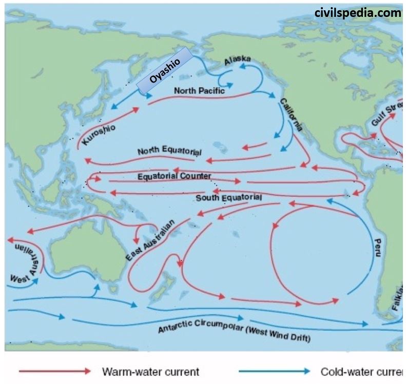
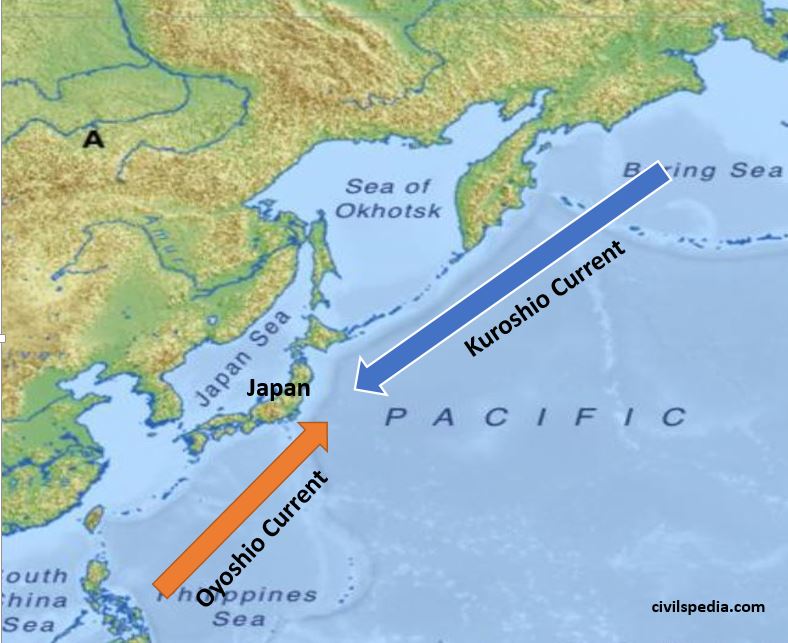
a. Oyashio current
- It originates from the Bering Strait and flows towards south carrying cold water.
- It meets with Kuroshio warm current
b. California Current
- Californian current is flowing towards south along the west coast of U.S.A between 48 N and 23 N latitudes.
- Has desiccating effect which leads to formation of Mohave and Sonoran desert.
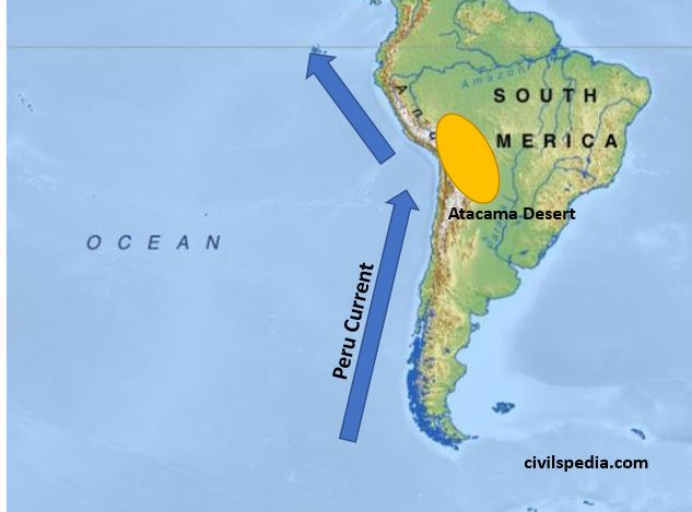
c. Peru Current
- Peru Current is the best studied ocean current of the Pacific Ocean.
- Alexander Von Humboldt in 1802 noted the details of the Peru Current. Hence, it is also known as Humboldt Current.
- It flows north along the west coast of South America carrying cold water
d. Alaska Current
- Cold current originating near Alaska and flowing south to meet North Pacific Current
e. West Wind Drift
- It is an easterly moving drift in the Pacific Ocean extending from Tasmania to the South American coast. It is a cold current.
- The speed of the drift is greater under the influence of Roaring Forties.
Warm Currents of Pacific Ocean
a. North Equatorial Current
- North equatorial current originates from Revilla Gigedo island west of Mexico due to trade winds and flows towards the Philippines Island covering a distance of about 12,000 km
- It gets divided into two and the northern branch joins the Kuroshio Current and the southern branch abruptly turns and forms the Pacific counter current.
b. South Equatorial Current
- South equatorial current is originated due the action of the trade winds from east to west
- It is stronger than the North equatorial current.
- It is further divided into many branches due to the presence of many islands and uneven surface topography.
c. Kuroshio Current
- Warm ocean current flowing in north easterly direction up to 30 N latitude
- It meets Oyashio cold current off the Kuril Islands.
d. East Australian Current
- Warm current flowing southward along the east coast of Australia
Side Note : Japan is good Fishing Ground
- Warm Kuroshio Current & cold Oyashio Current meets near Southern Japan. Hence, it becomes rich fishing ground.
- Along with that Japan has very shallow continental Shelf leading to more photic zone and more marine organisms.
- Indented coastline of Japan leads to formation of natural harbors .
- Furthermore, Japan is a hilly region with less developed agriculture . Hence, there is main role of fishes in Japanese Diet.
Side Note : Peru Current and Atacama Desert
Peru / Humboldt current is cold current. Hence, it provides desiccating effect to the South American coast leading to formation of Atacama Dessert . Atacama desert is one of the driest places on Earth.
Current Topic : Pacific Garbage Patch
Pacific Ocean Garbage Patch is an enormous collection of marine debris (mainly plastic) that is collected and deposited by ocean currents in the middle of the North Pacific Ocean.
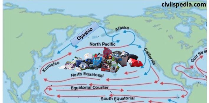
Reasons of formation
- Geographical : Circular motion of the ocean currents draws debris into the center which is calm & stable, where it becomes trapped.
- Almost 80% of the debris in the Great Pacific Garbage Patch comes from land-based activities in North America and Asia& the remaining 20% from boaters, offshore oil rigs, and large cargo ships. The amount of debris in the patch accumulates since most of it is non-biodegradable, mainly microplastics.
Impact
- Destruction of marine life due to ingestion of toxic and harmful substances .
- These toxic substances also enters the food chain resulting in biomagnification
- Presence of the garbage blocks the sunlight from reaching the planktons and algae, thereby reducing productivity of marine ecosystem.
- It affects the free flow of traffic through oceans.
- Impacts the tourism and economic livelihood of small Pacific Ocean island countries
2.3 Currents in Indian Ocean
Current system in Indian Ocean is unique & different from other current systems .
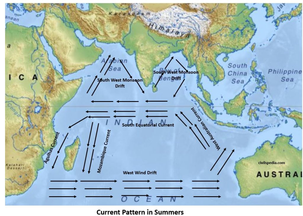
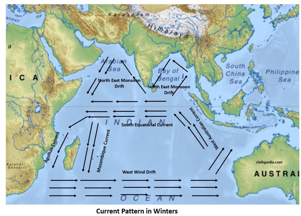
Why it is different than other currents?
- In northern hemisphere, it is confined to tropical zone only & that too is divided by Indian peninsula to form Arabian sea & Bay of Bengal.
- Complete reversal in direction of winds as monsoon winds also impacts the movement of current.
(wind is important factor – direction in which winds flow determine direction of currents ).
Side Note : Navigation in Indian Ocean.
- In Summer , Wind & current flows toward India . Hence, sea vessel can move from Arabia to India .
- In Winter, Wind & current flows toward Arabia . Hence, sea vessel can move from India to Arabia .
Important for sea trade & cultural interaction since Ancient times.
Significance of Ocean Currents
- Ocean Currents play an
important role in earth’s climate by distributing the energy within the
ocean. Along with that, they impact the local climate as
- Warm ocean current increases the temperature of an area
- Cold ocean current decreases the temperature of an area.
- Currents also effect the
amount of rainfall.
- Warm water currents increase the rainfall because they bring winds along with them, laden with water vapours. North America, Ireland, Britain and south India receive rainfall because of this process.
- On the other hand Atacama desert remains dry because cold water currents don’t play any role in occurrence of rainfall. Due to this various deserts are situated on the western coast of Australia, South America and Africa.
- Currents helps in free navigation navigation as Norweigian Current keeps ports of Scandinavia navigable throughout the year and Kuroshio Current keeps ports of Japan navigable during winter.
- Conjugation of warm and cold water currents helps in increasing the development rate of ‘Plankton’, which is a diet of fish. This conjugation takes place of eastern coast near New Found land in North America, Bahia Blanca in South America, Japan coast in Asia etc. But on the other hand conjugation of currents forms dense fog which creates problem for marine navigation. Sometimes ships are not able to move because of this fog. This whole situation effects the economic activities of respective areas.
3. Vertical Motion of Ocean Water : Upwelling & Downwelling
Vertical circulation of ocean water takes place due to difference in salinity and temperature between the surface and the water deep below.
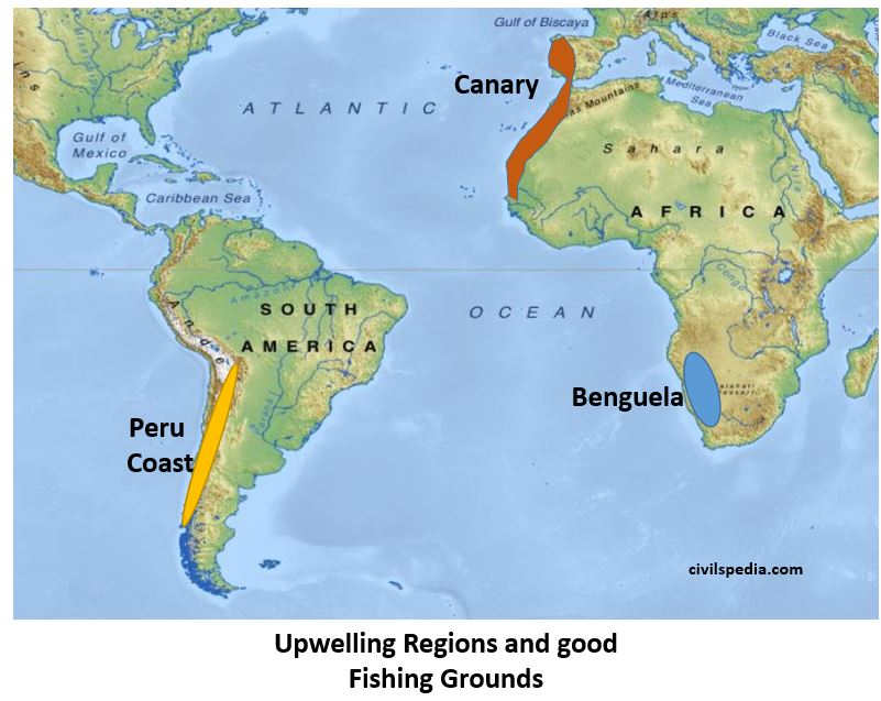
Upwelling
Upwelling is an oceanographic phenomenon that involves movement of dense, cooler, and usually nutrient-rich water towards the ocean surface, replacing the warmer, usually nutrient-depleted surface water.
UPWELLING & FISHING
- Cool & nutrient rich water come at surface.
- Phytoplankton reproduce rapidly in this condition => Consequently, fishes increase as well.
- All Upwelling Regions in World are good fishing ground. Eg : Canaries, Benguela and Peru Coast
Downwelling
- Down welling is the process of accumulation and sinking of cold high saline water beneath warmer or fresher water.
- Not good for fishing .
4. Vertical Movement : Tides
What are tides
- Rhythmic rise & fall in level of ocean water.
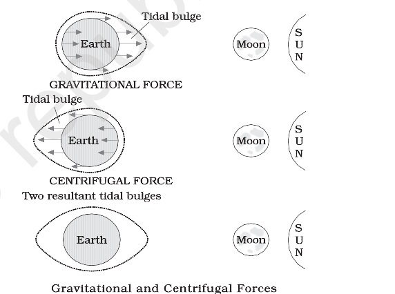
Causes of tide formations (Prelims-2015) .
- Moon’s gravitational pull is the most important factor.
- Sun’s gravitational pull ( although not as prominent factor as Moon’ pull but still a major factor)
- Centrifugal force due to earth’s rotation ( mainly responsible for causing bulges).
On the side of Earth facing the moon , a tidal bulge occurs while on the opposite side although the gravitational attraction of the moon is less as it is farther away, the centrifugal force causes tidal bulge on the other side
Stages of Tides
| Stage I | Sea level rises over several hours & cover the intertidal zone – flood tide. |
| Stage II | Water rises to highest level – high tide. |
| Stage III | Sea level falls over several hours revealing intertidal zone – ebb tide. |
| Stage IV | Water level stops falling – low tide. |
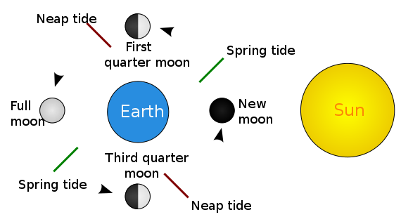
Syzygy
- Alignment of three or more celestial bodies of same gravitational system in a line.
- Effects tides in form of variation between high tides & low tides.
a. Spring tide
- Sun , moon & earth are in line.
- Occur on full moon or new moon (no moon day)
- When there is greatest variation between high tide & low tide .
- High tide is higher than normal high tide & low tide is lower than normal low tide.
b. Neap tide
- Sun , Earth & Moon are at right angle.
- Occur when moon is at quarter phase.
- High tide lower than normal high tide & low tide higher than normal low tides.
Daily frequency of Tides
Earth rotates & moon revolve in same direction, hence in relative term wrt to moon earth take 24 hrs & 52 minutes to complete one rotation.
- 2 high tides & two low tides in a day (24.52 hours to be exact)=Semidiurnal
- Most enclosed water bodies & bodies away from open ocean experience only one high & one low tide .
Tidal Current
- Movement of ocean water as a result of tidal action is known as a tidal current.
- In places of narrow coastal inlet these tidal currents flow rapidly through the mouth with greater height and velocity. For example in the Bay of Fundy, between Nova Scotia and New Brunswick of Canada, the difference between high and low tides is as high as 14m. Ports which utilize the tidal current for entry and exit of ships from the harbour are known as tidal ports.
Importance of Tides
- Creates inter-tidal regions which have special ecology of their own. Eg : Sunderbans
- Since tides are caused by the earth-moon-sun positions which are known accurately, the tides can be predicted well in advance. This helps the navigators and fishermen plan their activities. Tidal flows are of great importance in navigation.
- Tidal heights are very important, especially near rivers and within estuaries having shallow ‘bars’ at the entrance, which helps ships and boats in entering into the harbour.
- Tides are also helpful in desilting the sediments and in removing polluted water from river estuaries.
- Tides are used to generate electrical power (in Canada, France, Russia, and China). A 3 MW tidal power project at Durgaduani in Sunderbans of West Bengal is under way.
5. Thermo-Haline Circulations
- Circulation because of the temperature & salinity of the ocean.
- Main driving force is freezing of water at Atlantic and salinity .
Sequence
- First of all water goes to Polar Region ( Atlantic) . It interacts with the land which is very cold and freeze . When water freezes, it will increase the salinity of sub-surface water (because salt separates from water before freezing) .
- Subsurface water will become dense and goes further down. Consequently, it starts to flow as sub-surface cold current. It will come to South Atlantic ocean and from there to Indian and Pacific Ocean till the Bering Strait where it upwells .
- Then surface water starts to flow back .
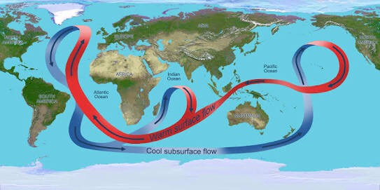
Note : This process is very slow and time frame between downwelling and upwelling can take upto thousand years .
Impact of Climate Warming on this
- Due to climate change , more fresh water is being added in Atlantic . This will reduce the salinity which is the driving force behind whole process.
- Hence, climate change and global warming will negatively impact this circulation
kuroshio current is a warm current and goes towards north not south do check it makes a wrong information in aspirarnts .(emotion :frustrated and pleasing and angry also ) please change .
I have written the same. I think you misunderstood while reading.
In the map given below the side-topic: Japan is a good fishing ground, Kuroshio and Oyoshio current tags are exchanged.