Table of Contents
Relief features of Ocean
This article deals with ‘Oceanography: Relief features of Ocean.’ This is part of our series on ‘Geography’ which is important pillar of GS-1 syllabus . For more articles , you can click here
Introduction
Hydrosphere covers 70% part of Earth surface and is one of most important Spheres for various living organisms and vegetation. Of the hydrosphere, 97.2% of water on Earth is present in Oceans.
The oceans, unlike the continents, merge so naturally into one another that it is hard to demarcate them. The geographers have divided the oceanic part of the earth into five oceans, namely the Pacific, the Atlantic, the Indian, Southern ocean and the Arctic. The various seas, bays, gulfs and other inlets are parts of these four large oceans.
Oceanic Crust
- Oceanic Crust is the most fundamental crust.
- It is Basaltic in nature .
- Oceanic crust is more denser & darker than Continental Crust.
- Age of continental shelfs is 1 billion year, oceanic crust is younger & nowhere aged more than 200 million years .
- Deepest point in ocean is Mariana Trench (in Pacific ocean near Northern Mariana Islands with depth 10,971 m )
- Oceanic Crust is created at Mid Oceanic Ridge & destroyed at Trenches.
- Ocean floor is not flat & more diverse than continents & quite different from continental ones.
- Oceans consist of 71% of earth’s crust.
Division of Ocean
To study ocean bottom properly it should be divided into two divisions
- Ocean Continent Margin.
- Deep Ocean Plains.
1 . Ocean Continent Margin
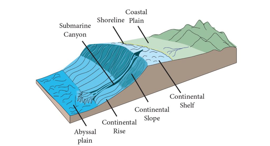
Meeting point of ocean & continental crust . It can be divided into three parts.
- Coast / Coastal Plain
- Continental Shelf
- Continental Slope
- Continental Rise
1 . 1 Coast
Coast can be of two types
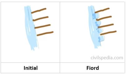
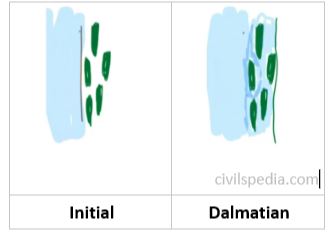
- Submergent Coast : Estuarine , Ria , Fiord and Dalmatian
- Emergent Coast
1 . 1 . 1 Submergent Coast
a. Fiord
- Initially mountains are perpendicular to the coast . Glaciers come down to the coast forming u-shaped valley submerging the area. Hence, coastline which was initially straight becomes indented
- Eg : Norwegian Coast
b. Ria
- If valleys were submerged by rivers (instead of Glaciers) , it is called Ria
- Eg : South Hampton, Wales, British Isles etc
c. Dalmatian
- If mountains are parallel to the coast (instead of perpendicular)
- If ships are entering this coast, they face barriers
- Eg : Adriatic Coast (Italy)
d. Estuary
- If normal low land region (not mountainous) is submerged at the mouth of river .
- Eg : Thames, Buenos Aires
1 . 1.2 Emergent Coast
a. Lowland Emergence
- It usually results in lagoon, salt marshes, long beaches
- Eg : Eastern Coast of India
b. Emergent Upland Coast
- No natural harbors are found here
- Eg : Scotland
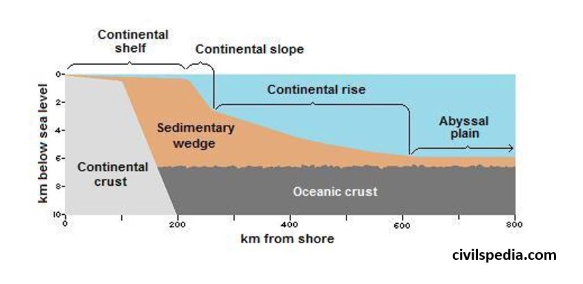
1 . 2 Continental Shelf
- Continental shelf is the seaward extension of land that lies under the sea water. It occupies 7% of the sea floor.
- It is quite shallow (approx 200m ).
- Region is called PHOTIC REGION ie receives large amount of sunlight . Marine organisms are found here (all floating planktons , benthos(crabs) & nektons(fishes)).
- It has gentle slope with an average gradient of 1° or even less. The shelf typically ends at a very steep slope, called the shelf break.
- Width varies – The shelves are almost absent or very narrow along some of the margins like the coasts of Chile, the west coast of Sumatra, etc. On the contrary, the Siberian shelf in the Arctic Ocean, the largest in the world, stretches to 1,500 km in width . (average width is 80 km)
- The depth of the shelves also varies. It may be as shallow as 30 m in some areas while in some areas it is as deep as 600 m (Less depth means it will have more photic zone).
- Made up of Granite rock ( because it is part of continental crust).
- The continental shelves are covered with variable thicknesses of terrigenous sediments brought down by rivers, glaciers, wind, from the land and distributed by waves and currents. Massive sedimentary deposits received over a long time by the continental shelves, become the source of fossil fuels.
Continental shelves are well known for oil, natural gas, mineral deposits, sulphur, marine fishery etc. Large number of resources are found in continental Shelf.
a. Petroleum
- 90% of petroleum reserves of world are found on continental shelves.
- Because petroleum is formed from submergence of marine living organisms which get converted to petroleum under high temperature & pressure (marine organisms like fish etc are maximum on Continental Shelf because of Photic Zone)
- Examples : Bombay High, Gulf of Cambay, Persian Gulf, North Sea, Barents Sea(Russia) , Gulf of Mexico, Norwegian Sea .
b. Sulphur
- Rarely found on land .
- Available in sea because of marine volcanism .
- Gulf of Mexico is rich source of Sulphur.
c. Placer Deposit
- Wave action erode beach rocks but there are some materials in rock which don’t disintegrate easily . Disintegrated material of lower weight is moved very swiftly by waves but heavy non-disintegrated material keeps on concentrating on shelf . These are called Placer Deposit.
- Example are as follows
- Monazite Sand found on Kerala Coast which is source of Thorium . It is important for Indian Nuclear Program
- Gold in Alaska .
- Zircon on coast of Brazil & Australia.
- Diamond on South African Coast .
d. Calcium
- Least soluble in ocean water & can be easily extracted .
- Peruvian coast is rich in Calcium & Phosphate .
e. Fishes
- Due to photic zone and availability of planktons , fishes are also found in the wasters of Continental Shelf.
- World famous fishing grounds like Grand Bank are situated here
f. Pearls
- Pearls of ornamental value are also found here.
Side Topic : Sea Boundaries (under UNCLOS)
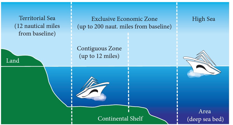
a. Internal waters
- All the water that is inside the coastline is called Internal Waters
- State has complete sovereignty over this and it is equivalent to territory of country
b. Territorial Sea
- Upto 12 Nautical Miles (1 NM = 1.85 Km) (provided there is no other country on the other side. If any other country is present, it becomes midway)
- Here too almost all of the laws of the land apply. It is almost as good as territory
- Vessel of any other nation need permission to enter into territorial waters of other country & submarine has to come on surface & declare its identity while navigation .
c. Contiguous Zone
- Upto 24 Nautical Miles .
- Some dilution of political laws
- Navy & Coast Guard cant guard this but if criminals like smugglers after doing some crime try to run then that country can follow them till this point .
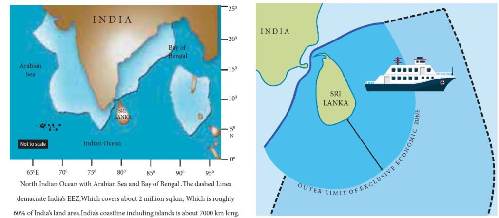
d. Exclusive Economic Zone (EEZ)
- Upto 200 Nautical Miles.
- All the economic laws of country apply but political laws don’t apply here
- Country can explore both biotic and abiotic resources of the water and ocean floor .
- Other countries have right to peaceful passage .
Exceptional Case
- If Continental shelf is beyond 200 Nautical Miles , country can claim EEZ upto that point with maximum limit of 350 NM
- Within this extended zone, state has exclusive right of exploiting and exploring non-living resources of the sea bed as well as sedentry species on the sea bed. Fishing rights arent inclusive in 200 to 350 Nautical Miles.
d. International waters / High Sea
- Beyond EEZ
- Here resources belong to everyone. No nation has sovereign rights over this area.
Side Topic : Nautical Mile
- It is the distance per one minute of latitude (1/60th of 1 degree)
- 1 Nautical Mile = 1.85 Km
(1.85*60=111 Km = Distance covered per degree latitude . )
At equator, 1 degree of longitude is also 111 km . But this distance keep on reducing while going North and South and is 0 at poles . But distance between latitudes is always same (because they are parallel) and is 111 km approx at every point
1 . 3 Continental Slope
- The zone of steep slope extending from the continental shelf to the deep sea plain or abyssal plain is called continental slope.
- It has very steep slope .The slope angle varies from 5° to 60°.
- No deposition is possible because of steep slope . Hence, no resources are found in this zone.
- But some unique landforms are created specially when there is mouth of very large river at continental shelf like Indus, Ganga, Mississippi, Yukon & Congo. Example of such landform are
- SUBMARINE CANYONS in which flow of water would be so great that it will vertically erode both continental shelf & slope . In Indian Ocean, submarine canyons are found at mouths of river Ganga and Indus.
- Underwater Waterfalls – Highest waterfall on earth is under the Denmark strait.
1 . 4 Continental Rise
- Transition between Continental Slope & Sea Floor.
- There would be no continental rise in case there is TRENCH after Continental slope .
2 . Deep Ocean Plains
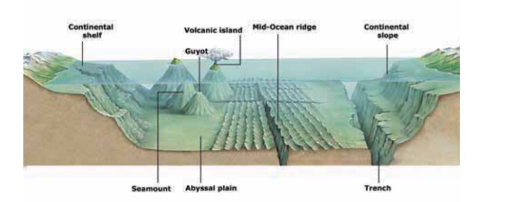
Major portion of Ocean Crust consist of Deep Ocean Plains which have various relief features like Mid Ocean Ridge, Islands, Guyots etc. These are as follows :-
2 . 1 Abyssal/ Deep Sea Plains
- Occupies 40% of ocean floor.
- Consists older parts of oceanic crust that are smoothened due to sediment deposition.
- Among flattest, smoothest & least explored regions of earth.
- Average depth varies from 3000 to 6000 metres .
- It has deposits from continents( terrigenous), marine life(biogenous) & salts and minerals(inorganic).
- Abyssal plains of Southern Indian Ocean and Eastern Pacific Ocean are rich sources of Poly Metallic Nodules.
Side Topic : Poly-Metallic Nodules (PMN)
- Polymetallic Nodules (AKA Manganese Nodules) .
- Multiple metals are concentrated around core .
- Found at depth of around 4,000 to 6,000 m on the floor
- Were first found around Kara Sea & Arctic sea but later nodules were found in all oceans .
- But are economically viable to extract only in Central Indian Ocean & Eastern Pacific Ocean.
- Composition : Manganese (Highest) and apart from this contain Iron , Silicon, Al, Nickel & Cobalt & some rare metals.
- Important for India as India doesn’t have good source of Nickel & Cobalt .
- Countries are in race to explore & extract PMN.
2. 2 Islands
An island is a landmass surrounded by water on all sides.
They are of four types
a. Continental Island
- Once part of large continent.
- Examples : Sri Lanka, Madagascar, Vancouver, Baffin islands.
- Note : Madagascar Island formed after separation from Indo- Australian Plate
- Generally bigger in size than all other categories of Islands.
- Rock composition and all of continental island is same as plate from which it is separated .
b. Volcanic Island
- Ocean – Ocean plate collision or Hotspot activity.
- Examples : Andaman & Nicobar Islands, Japan, Philippines, Kurile, Aleutian Islands, Hawaii etc
c. Coral Island
- Marine organisms, the coral polyps colonize the tropical warm water and form islands known as coral islands.
- Examples include Lakshadweep, Maldives, Mauritius, Bahama & Bermuda
d. Sandbar Island
- Formed by accumulation of sand near coast => Sand which is eroded from main land is again settled near coast & if continental shelf is shallow nearby then sandbar island is formed .
- Example : Long Island (New York)
Side Topic : Archipelago
- Cluster of islands .
- (GK) Largest archipelago.
| By area | Indonesia |
| By number of islands | Finland |
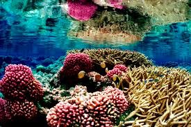
2.3 Coral Reefs
- Corals are indicative of health of Marine Ecosystem ie if coral reef exists at any place in healthy way , entire ecosystem is healthy.
- Wherever there is coral reef , you will find great biodiversity at that point.
- Most diverse ecosystem of world => 10% area but 25% marine species . They can be said to be Rain Forests of the Ocean.
What are corals?
- Corals are tiny fleshy Sea Anemones Polyps.
- They extract Calcium from sea water for their skeletons to protect their body.When one generation die other generation comes on it.
- Corals live in symbiotic relationship with microscopic algae- Zoo-xanthalae which have photosynthesis capabilities.
- Zoo-xanthalae provide food to corals and corals provide protection to zooxanthalae.
Conditions conducive for corals
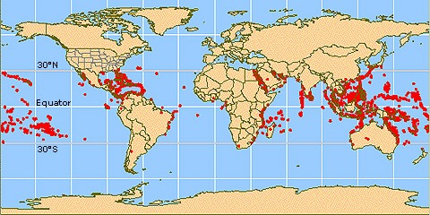
- Water temperature in the range of 22-29 degrees Celsius. Thus, areal distribution of corals is limited to tropical and sub-tropical zones.
- They will not flourish in areas of cold currents but thrive in warm current regions. Therefore, they are generally absent on western coasts of continents.
- Depth of water should not exceed 180 feet as the sunlight is too faint for photosynthesis which is essential for survival of microscopic Zoo-xanthalae on which coral polyps depend. However, there should be plenty of water as polyps cannot survive for too long out of water.
- Water should be salty and free of sediments. Corals are best developed on seaward side of reef, where constantly moving waves, tides and currents maintain an abundant supply of clear, oxygenated water
Spatial Distribution of corals in the world
Spatial distribution of Corals in India
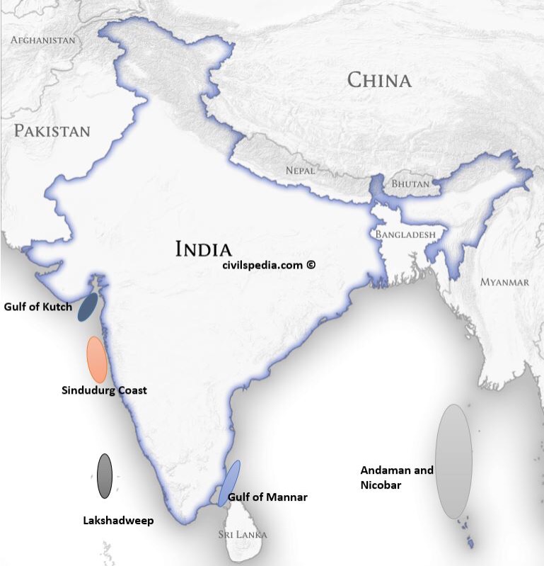
In India they are found in
- Gulf of Mannar.
- Andaman &Nicobar
- Lakshadweep
- Gulf of Kutch
- Sindudurg coast ( near Malvan Coast) in Maharashtra ( only here in India, bleaching hasn’t happened yet)
While the Lakshadweep reefs are atolls, the others are all fringing reefs.
Coral Bleaching
- When corals are in stress they expel Zoo-xanthalae.
- Zoo-xanthalae give the colourful appearance to corals . In their absence, corals seems white (their original colour) .
- Ultimately without food corals will die out too.
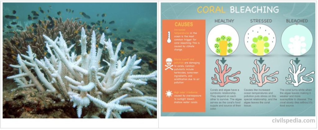
Reasons of coral Bleaching
- Global Warming : increase in sea surface temperature .
- Ozone Depletion : increase in solar irradiation.
- Ocean Acidification : because of increase in Carbon Dioxide in atmosphere . This Carbon Dioxide dissolves in ocean water & water becomes acidic . Corals can’t live in acidic water
- Algal Bloom : excessive use of fertilisers go to ocean through rivers resulting in Algal Bloom . Sunlight cant go below & corals die.
- Increase in sedimentation from rivers.
- Marine pollution like oil spills . No sunlight & oxygen reach below.
- Diseases.
- Coastal construction and shoreline development: Results in heavy sedimentation
- Coral mining: Live coral is removed from reefs for use as bricks etc.
Consequences of Coral Bleaching
- It will impact marine ecosystem, as coral reefs are some of the most bio diverse and productive ecosystems.
- Reefs act as natural barriers to shorelines, protecting them from the effects of moving water. As coral reefs die, coastlines become more susceptible to damage and flooding from storms, hurricanes, and cyclones.
- Ocean will not be able to absorb as much Carbon Dioxide because Zoo-xanthalae absorb Carbon Dioxide for photosynthesis leading to increased Global Warming.
Measures need to be taken
- Political measures: The global agreements combating climate change must keep the needs of coral islands as top priority.
- Switching to sustainable livelihood measures: It is high time to recognize the carrying capacity of each coral island ecosystem and limit population growth, tourist foot fall etc. at these islands.
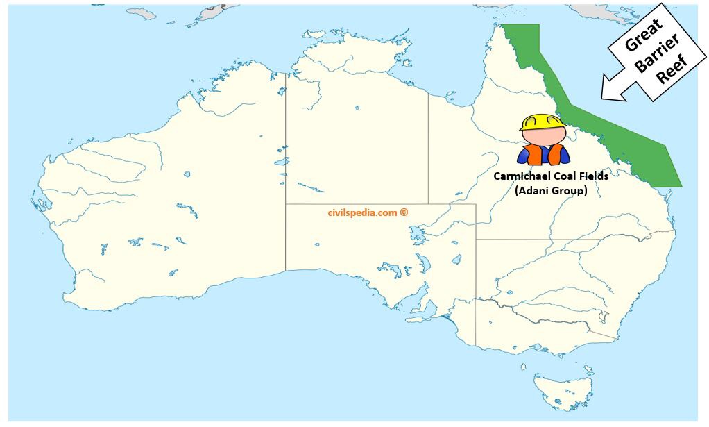
- Sustainable development : Avoid major projects in threatened areas. Eg : Carmichael Coal Mine in Australia that threatens Great Barrier Reef should be avoided.
Formation of Coral Reef
Coral Reef can be developed both at margins of continents or around islands .
3 stages of coral formation are as follows
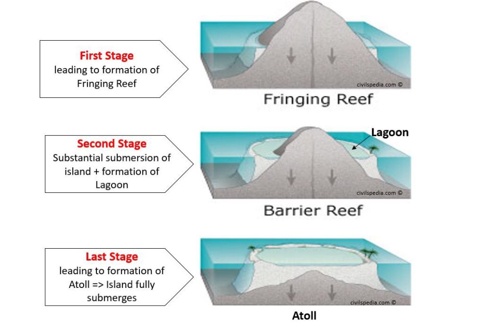
Stage 1 : Fringing
- Coral reef starts to develop along margin of an island & subduction of island just starts
- First stage of Fringing Reef
Stage 2 : Barrier Reef
- Corals keep on accumulating and keep on rising upwards. As a result, large part of island is submerged in sea/ocean.
- Lagoon formation occurs
Stage 3 : Atoll
- Last Stage
- Island is submerged & only ring remains visible .
Note : In India, while the Lakshadweep reefs are atolls, the others are all fringing reefs.
Side Topic : Great Barrier Reef , Australia
- Adani’s are investing in Coal Fields in Australia (Carmichael Coal Fields) . Project will create jobs for Australians and coal will be imported to India
- But due to large Carbon-dioxide emissions in the area , Great Barrier Reef will be impacted heavily.
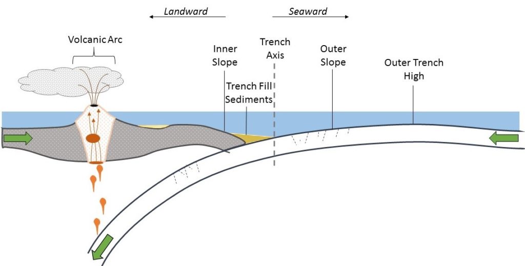
2.4 Oceanic Trench/ Oceanic Deep
- The long, narrow, steep-sided depressions formed along the convergent boundary where one plate subducts below the other is called Ocean trenches.
- The Challenger Deep in the Mariana Trench, (10,994 m) in the Pacific Ocean is the deepest part of the earth.
- Most trenches are in Pacific ocean & they are most active geological feature. Great earthquakes leading to Tsunamis occur here.
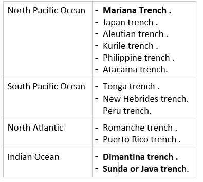
- As many as 57 deeps have been explored so far; of which 32 are in the Pacific Ocean; 19 in the Atlantic Ocean and 6 in the Indian Ocean.
Main Trenches of the world
2.5 Seamounts / Guyots
- Flat topped volcanic hills submerged under the sea water are called guyots.
- Seamounts are conical, volcanic hills submerged under ocean water
- Seamounts , guyots and the water column above them serve as important habitats, feeding grounds and sites of reproduction for many open-ocean and deep-sea species.
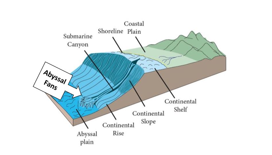
2.6 Abyssal Fans
- Also known as Deep Sea Fans or Underwater Deltas or Submarine Fans .
- Delta like structure formed at deep sea surfaces . Major reservoirs of biodiversity.
2.7 Mid Oceanic Ridge
- Mid-ocean ridges are submarine mountains.
- Mid oceanic ridges are located on the divergent plate boundaries where magma flows through the fissure to form new oceanic crust. They form the longest mountain range in the world extending for more than 56,000 km long.