Table of Contents
Rivers of Peninsular India
This article deals with the ‘Rivers of Peninsular India (UPSC notes)’. This is part of our series on ‘Geography’, which is an important pillar of the GS-1 syllabus. For more articles, you can click here.
Introduction
- Indian Peninsula is traversed by a large number of rivers which have existed for a much longer period than the Himalayan rivers. As such, the peninsular rivers have reached a mature stage and almost reached the base level of erosion.
- Due to the low gradient, the velocity and the load-carrying capacity of the river are low, and the rivers form big deltas at their mouths. It is especially observed in the east-flowing rivers pouring into the Bay of Bengal.
- But the west-flowing rivers of Narmada and Tapi and those originating from the Western Ghats and emptying their water in the Arabian Sea form estuaries instead of deltas.
- Some of the rivers also have waterfalls. E.g., The Jog Falls on the Shravati (289 m), Sivasamandram on the Cauvery (101 m) and Dhuandar (15 m) on the Narmada
Evolution of Peninsular Drainage
- Geologists think of the Sahyadri-Aravali axis as the primary water divide in the past.
- It assumes that the existing Indian Peninsula is the remaining part of a bigger landmass, with the Western Ghats located in the middle of the landmass dividing the entire drainage into two symmetrical parts – one flowing in the east and the other flowing in the west. But the western part of the Peninsula cracked and submerged in the Arabian Sea and disturbed the symmetrical plan of the rivers on either side of the watershed during the early Tertiary period.
- During the collision of the Indian plate, a second major distortion was introduced in the Peninsular block, and it was subjected to subsidence and consequent trough faulting through which now flow the main west-flowing Peninsular rivers, i.e. the Narmada and the Tapi.
Direction of flow
Although the general direction of flow of the Peninsular Rivers is from west to east, a careful study reveals at least three main directions of flow.
- Cauvery, Krishna, Godavari, Mahanadi and several smaller rivers drain southeast into the Bay of Bengal.
- Narmada, Tapi and several small streams originating from the Western Ghats flow westward into the Arabian Sea.
- Chambal, Betwa, Ken, Son, and Damodar (tributaries of Ganga and Yamuna) flow in a north-easterly direction.
Part 1: West-flowing rivers
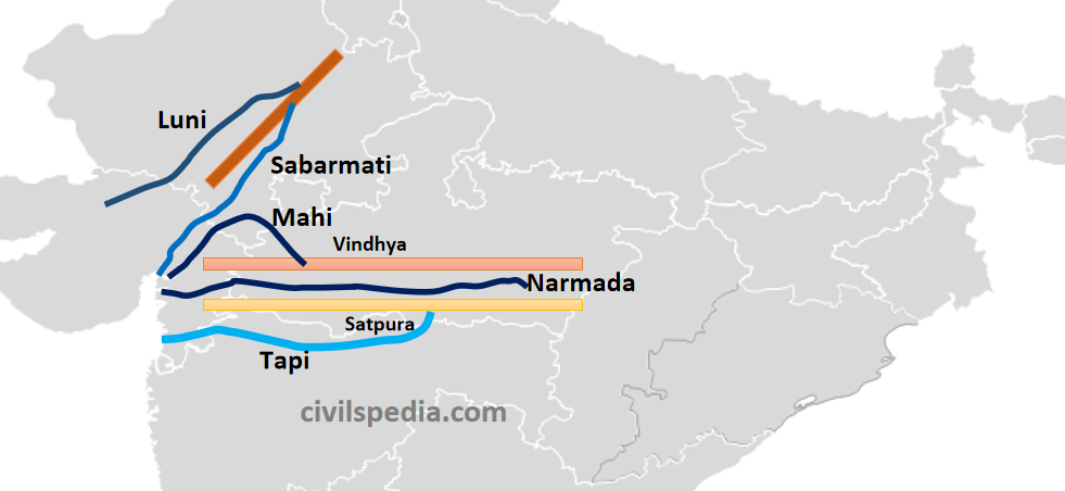
- The west-flowing Peninsular Rivers are fewer and smaller than their east-flowing counterparts.
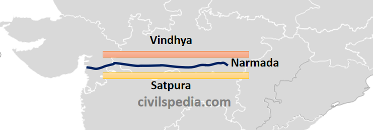
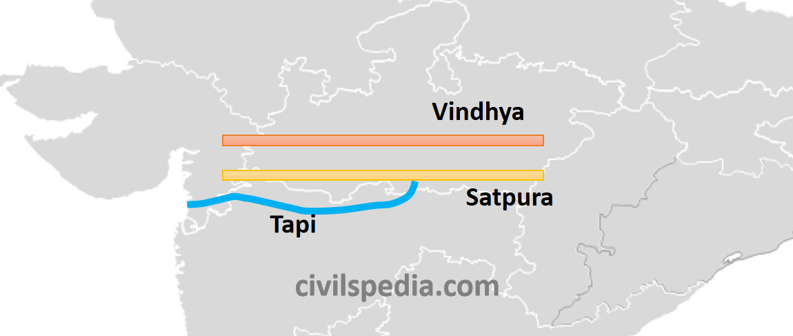
- The Narmada and the Tapi are the two main west-flowing rivers (the rest of them are small and swift flowing). This unusual behaviour of these two rivers is explained by the supposition that they do not flow in the valleys formed by themselves but have usurped for their channels two fault planes running parallel to the Vindhyas, which were created by the bending Northern Peninsula at the time of upheaval of the Himalayas.
- West-flowing Peninsular rivers that fall into the Arabian Sea do not form deltas but estuaries. It is due to the following reasons.
- The west-flowing rivers, especially Narmada and Tapi, flow through hard rocks and can’t form distributaries before they enter the sea.
- West-flowing rivers are of small lengths and do not have enough deposits to make deltas, whereas East-flowing rivers have large courses, large sediments & sluggish movement at the end.
- The East Coast is emergent, while the West Coast is submergent.
- They display a parallel pattern of drainage characterised by sharp bending.
1. Narmada
Origin
- Western flanks of Amarkantak Plateau in Madhya Pradesh
Length
- 1310 Km (largest west-flowing river)
Flow
- After rising from the Amarkantak Plateau, it flows through the rift valley between Vindhya & Satpura ranges.
- For 1078 km, it flows through Madhya Pradesh. Later, it forms the boundary between Gujarat and Madhya Pradesh for 32 km and between Maharashtra and Gujarat for another 40 km. Finally, it meets the Gulf of Khambhat after travelling for 160 km in Gujarat, forming an estuary.
- There are several islands in the estuary formed by Narmada, of which Aliabet is the largest.
- Near Jabalpur (Madhya Pradesh), the world-famous Dhuandhar Falls (15 m) lies on it.
Hydro Projects
- Various Hydro-projects like Indira Sagar, Sardar Sarovar, Omkareshwar, Bargi and Maheshwar have been constructed on it.
2. Tapi
Origin
- Near Multai Reserve Forest in the Satpura Range (Madhya Pradesh)
Length
- 730 km (second largest west-flowing river)
Course of River
- Tapi originates from Multai Reserve Forest and flows through the plains of Vidharbha, Khandesh and Gujarat, passing through (large areas of) Maharashtra and (small parts of) Madhya Pradesh and Gujarat.
- It finally falls into the Gulf of Khambhat near Surat, making an estuary.
- Note: Almost the whole of its course is below Satpura.
- Important industrial area of Surat (famous for the textile industry) and Nepanagar (famous for the paper and newsprint industry) lies in its basin.
- It is also known as ‘The Twin or Handmaid of Narmada’.
Hydro Projects
- Various Hydro-projects like Hathnur Dam, Girna Dam and Dahigam Weir (in Maharashtra) and Kakrapar Weir and Ukai Dam (in Gujarat) have been constructed on it.
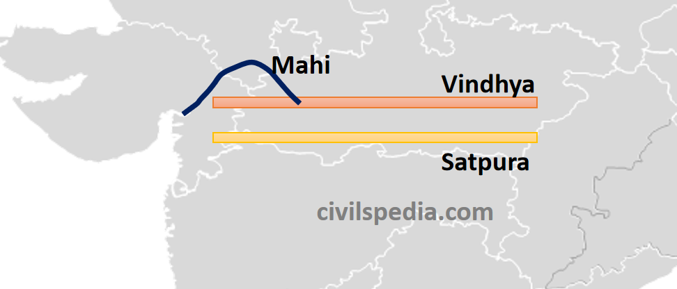
3. Mahi
Origin
- Vindhya Ranges
Length
- 533 Km
Course of River
- After rising from Vindhya Ranges, it flows through Madhya Pradesh, Rajasthan and Gujarat and empties itself in the Gulf of Khambat.
4. Sabarmati
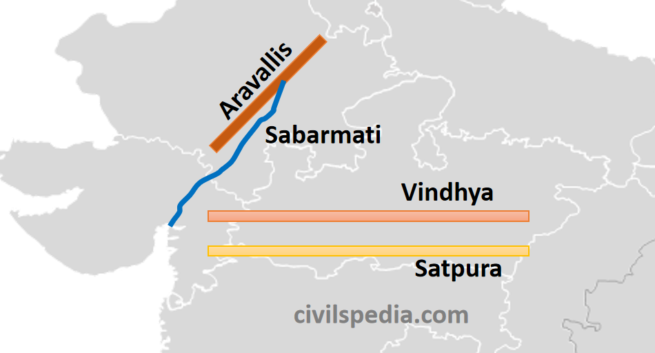
Origin
- Mewar Hills of Aravalli Range
Length
- 320 Km
Course of River
- River Sabarmati forms by the joining of two streams, Sabar and Lathmati.
- It rises from the Aravalli Range and falls in the Gulf of Khambhat after passing through Rajasthan and Gujarat.
5. Luni
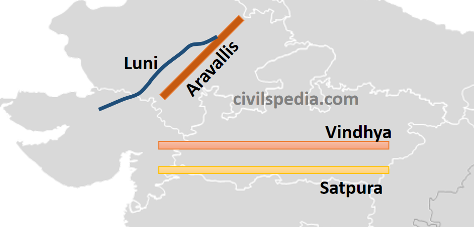
Origin
- West of Ajmer in Aravalli Range
Length
- 482 km
Course of River
- It rises west of Ajmer from the Aravalli range and flows southward.
- It is unique as it flows through the Thar Desert.
- It is known as Sagarmati in the upper course.
- Near Govindgarh, it joins Sarsuti/Saraswati (which originates from Pushkar Lake), and from this confluence, it gets its proper name as the Luni.
- It is finally lost in Rann of Kachchh.
- Note: River is named so because its water is brackish below Balotra.
Rivers rising from the Western Ghats
- The Western Ghats are the source of about 600 small streams that run west and ultimately drain into the Arabian Sea.
- The Western Ghats receive large rainfall from the southwest monsoons, large enough to feed many streams. Although it consists of 3% of the areal extent of the basins of India, they contain about 18% of the country’s water resources.
- The hydroelectric potential of these rivers is nearly 9500 MW, of which nearly 5500 MW is operational.
- Since these streams receive significant water from the monsoons, they drain excess rainwater to the Arabian Sea. Because of the relatively abundant water available in these rivers, some river water diversion programs have also been undertaken. E.g.,
- Periyar (west-flowing) – Vaigai (east-flowing) diversion project was developed during the British period, shifting excessive water from Periyar to Vaigai.
- Kurnool-Cuddapah Canal, which was initially planned for irrigation as well as navigation
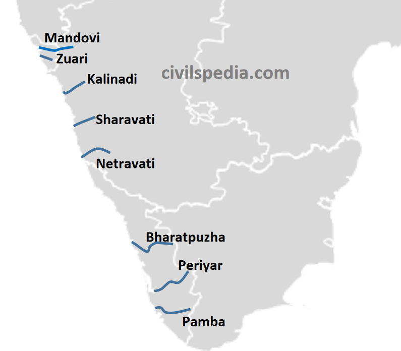
6.1 Mandovi and Zuari (Goa)
- Mandovi (Mahadayi) and Zuari are the main rivers of Goa.
- Both originate in the Western Ghats.
- They finally fall into the Arabian Sea.
- Famous Dudhsagar Falls lies on the Mandovi River.
- Currently, the Mahadayi river water dispute is going on between Goa, Karnataka and Maharashtra.
6.2 Kalinadi, Sahravati & Netravati (Karnataka)
- Kalinadi, Shravati and Netravati are the major rivers of Karnataka, which originate in the Western Ghats and fall into the Bay of Bengal.
- Among them, Shravati is famous for Jog Falls (Gerosoppa Falls), which lies on it.
6.3 Bharatpuzha, Periyar and Pamba (Kerala)
- Bharatpuzha, Periyar and Pamba are the main rivers of Kerala, originating in the Western Ghats.
- Periyar River is vital for agriculture and hydroelectric power.
- Pamba drains into Lake Vembanad.
Part 2: East-flowing rivers
1. Subarnarekha
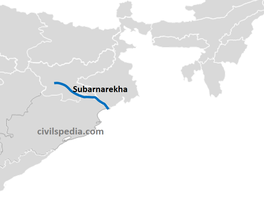
Origin
- From Ranchi Plateau in Jharkhand
Length
- 395 km
Course of River
- After originating from Ranchi Plateau, it flows southeast and forms a boundary between West Bengal and Odisha.
- It has a large number of waterfalls on it as it leaves Peninsular Plateau.
- Finally, it joins the Bay of Bengal, forming an estuary.
2. Brahmani
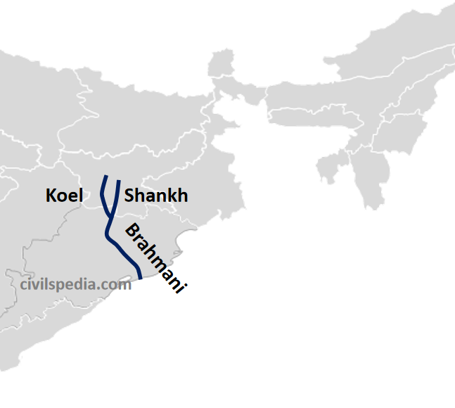
Origin
- After the confluence of Shankh & Koel rivers at Rourkela, both of which originate from the Chotanagpur Plateau.
Length
- 800 Km
Course of River
- Brahmani River forms after the confluence of the Sankh and Koel rivers
- Finally, it drains into the Bay of Bengal above Paradwip Port, forming a delta.
3. Mahanadi
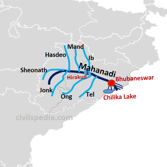
Origin
- Northern foothills of Dhankarnaya (Chhattisgarh).
Length
- 857 Km
Course of River
- The river originates in the foothills of Dandakaranya and then travels through a saucer-shaped basin called ‘Chhattisgarh Plain’. A number of hills surround this basin, and as a result, it is joined by many tributaries like Ib, Mand, Hasdo and Sheonath on the left bank and Ong, Tel and Jonk on the right bank.
- Later, it enters Odisha, where Hirakud Dam is built on it.
- It forms a gorge on reaching the eastern ghats and empties itself in the Bay of Bengal, forming a (birdfoot) delta. Bhubaneshwar is located on the apex of the Mahanadi delta.
Tributaries
- Left Bank: Ib, Mand, Hasdo and Sheonath
- Right Bank: Ong, Tel and Jonk
4. Godavari
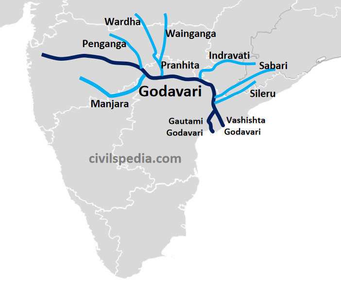
Origin
- Trimbak Plateau of Western Ghats near Nashik (Maharashtra)
Length
- 1465 km (It is the largest Peninsular river and next only to Ganga and Indus Systems)
Other names
- Vridha Ganga
- Dakshin Ganga
Course of River
- From Trimbak Plateau, it flows eastwards till Nashik, from where it leaves the Western Ghats and opens up.
- Subsequently, it receives a large number of tributaries. These include right bank tributaries like Manjra and left bank tributaries like Penganga, Pranhita (Wardha and Wainganga join to form Pranhita), Indravati, Sabri & Sileru.
- After Maharashtra, the river enters Telangana and subsequently to Andhra Pradesh. In Andhra, the river divides itself into two streams, i.e. Gautami Godavari and Vashishta Godavari, before pouring into the Bay of Bengal, forming a delta characterised by a number of Paleochannels & Mangroves associated with lagoons.
Tributaries
A large number of tributaries.
| Left | Penganga, Pranhita (Wardha and Wainganga joins to form Pranhita) ,Indravati, Sabri & Sileru. |
| Right | Manjra |
5. Krishna
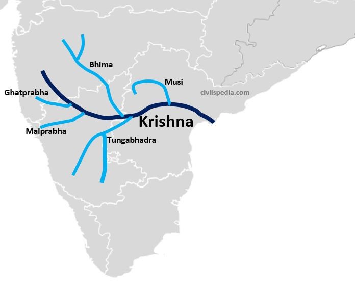
Origin
- Western Ghats near Mahabaleshwar (Maharashtra)
Length
- 1400 km (it is the second largest Peninsular river)
Course of River
- It rises in Mahabaleshwar, and after passing through Karnataka, it enters Andhra.
- Finally, it merges with the Bay of Bengal, forming a birdfoot delta (Mississippi type).
- During the flow, it receives tributaries like Koyna, Ghataprabha, Malprabha, Bhima, Tungabhadra, and Musi are its important tributaries.
- It finally meets the Bay of Bengal, forming a large delta.
About Tributaries
- Koyna is a small tributary but is very famous for Koyna Dam. The Dam was probably the primary cause of the devastating earthquake of 1967.
- Tungabhadra is formed by the merging of the Tunga and Bhadra rivers.
- Musi joins Krishna near Wazirabad. The famous city of Hyderabad is located on its banks.
6. Pennar
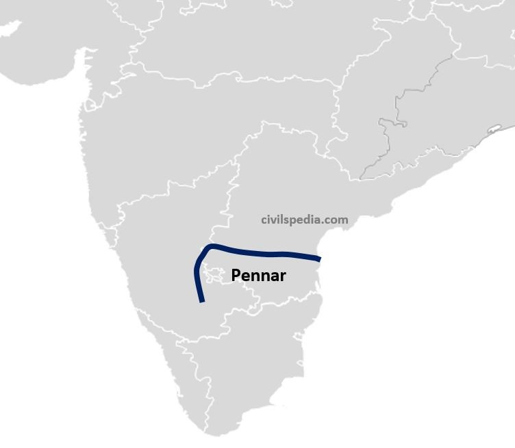
Origin
- Dandi Durg peak in Karnataka.
Length
- 597 Km
Course of River
- After originating from the Dandi Durg peak, it flows northward.
- Then it enters Andhra Pradesh and takes an easterly course.
- It finally joins the Bay of Bengal, forming a narrow estuary.
7. Kaveri/Cauvery
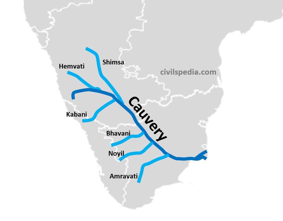
Origin
- Taal Kaveri on the Brahmagiri hills, situated in Coorg Plateau
Length
- 800 Km
Another name
- Dakshina Ganga or Ganga of the South
Course of River
- It originates at Taal Cauvery and then flows eastwards to reach the Bay of Bengal.
- About 3% of the Kaveri basin falls in Kerala, 41% in Karnataka and 56% in Tamil Nadu.
- This river is perennial with comparatively lesser fluctuations in flow as its upper catchment area receives rainfall during summer by the southwest monsoon and the lower catchment area during the winter season by the retreating northeast monsoon.
- It is one of the best-regulated rivers, with 99% of its irrigation potential already harnessed. Major dams include Krishna Raja Sagar Dam (Mysore) and Mettur Dam.
- During the course, it joins various tributaries. These include left-bank tributaries such as Hemvati and Shimsa and right-bank tributaries such as Kabani, Bhavani, Noyil and Amravati.
- It finally falls into the Bay of Bengal, a few kilometres above Tiruchirapalli, forming the quadrant Delta in the Thanjavur district of Tamil Nadu.
8. Vaigai
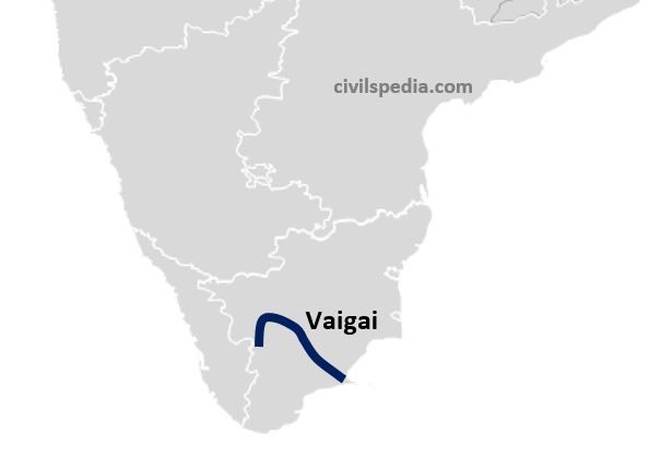
Origin
- Varushand Hills
Course of River
- It flows south of Cauvery and lies entirely in Tamil Nadu. It flows through dry channels, tends to get lost intermittently, and reappears on the surface.
Himalayan vs Peninsular Rivers
| Himalayan Rivers | Peninsular River | |
| Name | These rivers originate from Himalayan mountains covered with glaciers. | These rivers originate from the Peninsular Plateau |
| Basins | Himalayan rivers have large catchment areas and basins | Peninsular rivers have small catchment areas and basins |
| Nature of flow | Perennial: They receive water from glaciers and rainfall. | Seasonal: They are dependent on monsoon rainfall. |
| Valleys | Himalayan rivers flow through deep I-shaped valleys called gorges. | Peninsular rivers flow through comparatively shallow valleys. |
| Type of drainage | Antecedent & consequent leading to the dendritic pattern in plains. | Superimposed and rejuvenated, resulting in trellis, radial and rectangular patterns. |
| Stage | Himalayan rivers are in their youthful stage. | Peninsular rivers have reached maturity. |
| Meanders | Himalayan rivers meander when they enter plains owing to a sudden reduction in speed. | The hard rock surface of the plateau permits little scope for the formation of meanders. Hence, these rivers have more or less a straight course. |
| Deltas and Estuaries | Himalayan rivers form big deltas. E.g., The Ganga-Brahmaputra Delta is the largest delta in the world. | Some Peninsular rivers, such as Narmada and Tapi, form estuaries. Other rivers such as Mahanadi, Godavari, Krishna and Cauvery form deltas. |
This is the most simplified yet extensive explanation of peninsular river system.
I appreciate the hardwork.
Thank you very much.
Thanks for such a kind review. Please share the word with others.
You are the best. If possible, could you create a map showing all the rivers? You have a talent for making difficult things easy to remember.
We will try to do that
crystal clear and to the point explanation with maps, grate job, thanks alot for this website.
Thanks for the appreciation. Please help us in spreading the word about the website.
very good explanation and specially images were very easy to understand with a very simple code
thank you
Great work, it is appreciable.
Thank you. And spread the word about our initiative
very good explanation through map and tq for making the topic easy to understand..thank you
you are doing great job .
god bless you
Thank you. Spread the word.