Table of Contents
The Coastal Plains
This article deals with ‘The Coastal Plains (Geomorphology of India).’ This is part of our series on ‘Geography’, which is an important pillar of the GS-1 syllabus. For more articles, you can click here.
Introduction
The narrow coastal strip between the edges of the Peninsular plateau and the coastline of India running for a distance of six thousand kilometres from the Rann of Kutch in the west to the Ganga-Brahmaputra delta in the east is called Coastal Plains.
Indian Coastal Plains are of two types i.e.
- West Coastal Plains
- East Coastal Plains
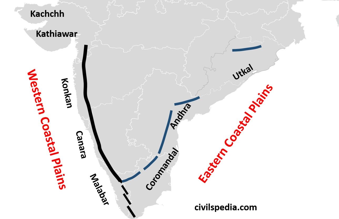
1. West Coastal Plains
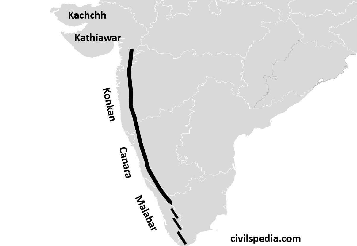
- It stretches from Rann of Kutch in the north to Kanyakumari in the south.
- It is the coastline of Submergence except for the Kutch and Malabar regions.
- These are very narrow (average width = 65 km). It is quite narrow in the middle and a bit broader in the north and south.
- They receive very heavy rainfall, because of which laterite soil is found here. As a result, they are not very important for agriculture except for some plantation agriculture such as Cashewnut (Maharashtra and Karnataka), Coconut (Kerala), Tapioca and Rice.
They can be divided into the following parts
a. Kutch Peninsula
- Kutch region is an emerged coast. It was an island surrounded by sea and lagoons. The sediments brought by the Indus River, which once flowed across this region, eventually filled these seas and lagoons.
- It is an arid and semi-arid region receiving very less rainfall. The Arabian branch of the South-West monsoon passes by without causing any rain because of the absence of any obstruction to cause Orographic rainfall.
- One of India’s busiest and most important ports, i.e. Kandla Port, lies in this region.
- It is famous for salt mining.
- The grassland in the Kutch region is known as Banni grasslands.
- Kutch region is famous for Kharai camels which are swimming camels and facing threats due to salt mining and the destruction of mangroves.
- The Kutch festival is celebrated every year, showing the unique landscape of white sands. Sands are white due to salt.
- The most famous attraction is Mandvi Beach because of its white sand, purity of water and pearls.
b. Kathiawar Peninsula
- It is a submerged coastline.
- It is a region of black soil due to Deccan lava.
- Due to black soil, it is famous for cultivating cotton, groundnut and tobacco.
- Basaltic and volcanic mountains known as Gir Ranges are situated in this region. Gir ranges are also famous for Asiatic Lions.
c. Konkan Coast
- It is a submerged coast extending from Daman to Goa, passing through Maharashtra.
- India’s commercial capital lies in this region. Mumbai was an island, but parts of the sea lying between Mumbai and the mainland have been reclaimed in the recent past.
- It is also rich in Petroleum resources. Bombay High lies here.
- Famous west flowing river Mandovi or Mahadevi flows through the Konkan Coastal plains. Dudhsagar waterfall lies on the Mandovi River.
d. Canara Coast
- It is a submerged coast lying in Karnataka.
- It is famous for west flowing river Shravati. Jog Falls (271 m) lie on the Shravati River.
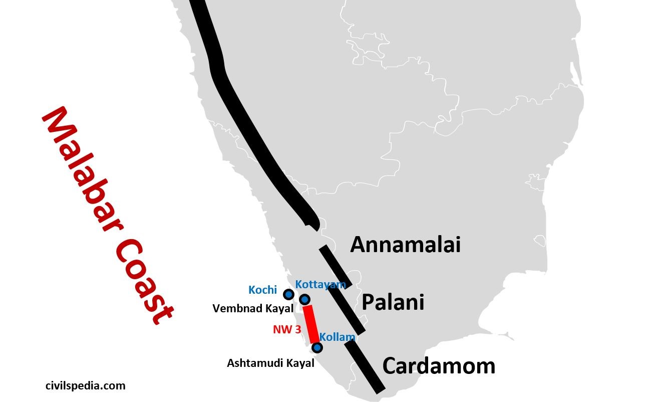
e. Malabar Coast
- Malabar coast lies between Mangalore and Kanyakumari. It includes Southern Karnataka and Kerala.
- It is a coastline of emergence and therefore has numerous lagoons and backwaters.
- It is much wider as compared to the other parts of the western coast.
- It is a low-lying plain with a height at no place exceeding 30 m above sea level.
- Distinctive characteristics of the Malabar coast include lakes, lagoons, and “Kayals” (backwaters). Backwaters are shallow lagoons, and the largest among them is Vembanad Kayal or Vembanad Lake, which is 75 km long and 5-10 km wide. Kochi is situated on its opening.
- Lake Vembanad is linked 4 other large lakes by canals and fed by 38 rivers to form National Waterway 3 from Kottayam to Kollam.
- This region is also famous for Kuttanad underwater rice cultivation and has been given the tag of GIAHS (Globally Important Agricultural Heritage Systems) by Food and Agriculture Organisation (FAO). ( India has three GIAHS- two others being Pampore Saffron cultivation of Kashmir and Koraput traditional agriculture of Odisha)
2. Eastern Coastal Plains
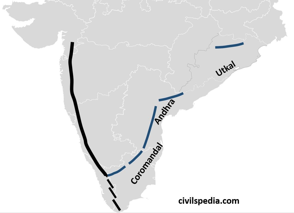
- Eastern Coastal plains stretch from Subarnarekha river along West Bengal- Odisha border to Kanyakumari.
- A major portion of the Eastern Coastal Plains has been formed by the depositional work of rivers Mahanadi, Godavari, Krishna and Kaveri, making some of the world’s largest deltas.
- In contrast to the Western Ghats
- They are wider, with an average width of 120 km.
- They are coastlines of submergence.
They can be divided into the following parts
a. Utkal Plains
- Utkal plains comprise coastal Odisha.
- It includes the Mahanadi Delta with Cuttack at its head.
- The most prominent physiographic feature of Utkal plains is Chilika Lake having the following features.
- River Daya drains into the Chilika Lake (south of the Mahanadi delta).
- It is the biggest lake in India.
- It is famous for Olive Ridley Turtles, Salt Water Crocodiles and the largest number of migratory birds from Siberia, including Siberian Crane, Flamingos and White Bellied Eagles.
- It is famous for an island known as Nalbana Island, which has Nalbana Bird Sanctuary.
- Apart from that, Bhitarkanika is another important feature.
- It is India’s second richest mangrove region located in the delta of the Baitarani, Brahmini and Mahanadi rivers.
- The dense forests of Bhitarkanika have made it an important breeding ground for Olive Ridley Turtles and an important habitat for Indian saltwater crocodiles.
b. Andhra Plains
- It extends from the south of the Utkal plains to Pulicat Lake (40 km north of Chennai).
- It is drained by Godavari, Krishna and Penneru rivers.
- Vishakhapatnam, the only natural port on the eastern coast, lies in Andhra coastal plains.
It is famous for Kolleru Lake and Pulicat Lake.
| Kolleru Lake | – It is between the delta of Godavari and Krishna. – It was once a brackish water lake or lagoon. But due to the extension of the delta, it has now been converted into a freshwater lake. |
| Pulicat Lake | – It is the second-largest brackish water lake (or lagoon) in India. – It is shared by Andhra Pradesh and Tamil Nadu. – It is famous for an island in its mouth known as Sriharikota, the satellite launching centre of ISRO. |
c. Coromandal Coast
- It extends from Lake Pulicat to Kanyakumari along the Tamil Nadu coast.
- It is drained by rivers Kaveri and Vaigai.
- The Delta of the Kaveri River and large-scale irrigation facilities have made this region the granary of South India.
- It is famous for rice cultivation.
Side Topic: Difference between Eastern & Western Coast
| Western Coast | Eastern Coast |
| From Rann of Kutch to Kanyakumari as a narrow strip of land between the Arabian Sea & Western Ghats | From Kanyakumari to Sundarbans, as relatively broader strip between Eastern Ghats & Bay of Bengal |
| Highly influenced by South West monsoon. | Influenced by North East monsoon, although it get monsoon from South West monsoon as well |
| Rivers form estuaries | Deltas, long beaches, salt marshes, lagoons etc., are commonly formed |
| Example of Submergent coast | Example of Emergent coast |
| Less attacked by cyclones | More attacked by cyclones |
Why does the West Coast provide good ports than the East?
- West Coast is Submergent Coast, whereas East Coast is Emergent Coast implying that Western Coast is deeper than Eastern Coast, providing favourable conditions for natural ports.
- Western rivers form Estuaries, whereas Eastern rivers form Deltas, which require constant dredging to maintain the required depth necessary for the entry of ships.
- Building excellent ports and harbours in the East is challenging since the continental shelf stretches 500 km into the ocean.
- Due to the construction of the Suez Canal, the importance of the Western Coast increased as it provided a shorter route between India and Europe.