Table of Contents
The Great Northern Plains
This article deals with ‘The Great Northern Plains (Geomorphology of India).’ This is part of our series on ‘Geography’, which is an important pillar of the GS-1 syllabus. For more articles, you can click here.
Introduction
- Northern Plains are the ‘aggradational plains‘ or ‘depositional plains‘ formed by the depositional works of three major Himalayan river systems viz, the Indus, the Ganga and the Brahmaputra.
- It extends from the foothills of the Himalayas to the northern edge of the Peninsular Plateau.
- Surface features of Northern Plains include
- Northern Plains of India have a remarkably homogeneous, monotonous, levelled surface with an imperceptible slope.
- This entire plain region has a network of rivers and choes, due to which Doab regions have been formed.
- The uniform structure of soft alluvial soil with imperceptible slopes has helped in the development of the ‘Dendritic Drainage Pattern.’
- Because the whole of the plain is formed by the deposition of alluvium by the rivers, landforms like alluvial fans, alluvial cones, meandering river terraces, natural levees, and flood plains are found in it.
- These plains extend approximately 3,200 km from east to west, making it the largest arable land in the world.
- The average width of these plains varies between 150-500 km. Width decreases from west to east.
- The average height is 200 m above sea level. This height increases between Ambala to Saharanpur, known as Delhi Ridge, which acts as a dividing line between the Indus and Ganga river systems.
Formation of Northern Plains
- Northern Plains are the youngest physiographic feature in India.
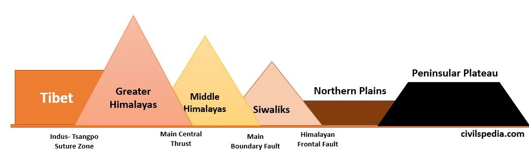
- Northern plains were formed in the Tertiary period due to the deposition of sediments in the ‘depression’ or ‘foredeep’, which lies between the Himalayas and the Peninsular Plateau. This depression was formed because the Indian plate, after the collision, abducted (a type of subduction in which the tectonic plate doesn’t melt) below the Eurasian Plate. The mighty rivers originating from the Himalayas deposited the sediments forming one of the flattest land on the earth, known as the Great Plains.
- Note: The Peninsular rivers also contributed to forming Northern Plains like Chambal, Son etc.
- The Himalayan Frontal fault separates the Shivaliks from the Great Plains.
Divisions of Northern Plains
Northern Plains can be divided in two ways as follows
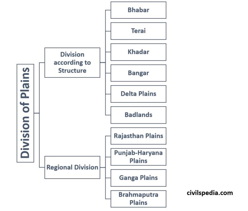
1. Division based on Structure
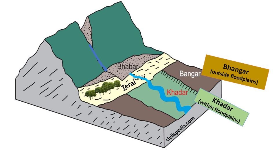
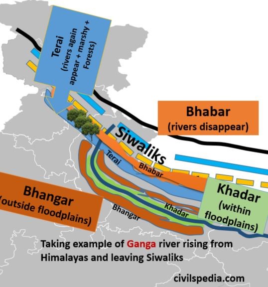
1.1 Bhabar Plain
- Bhabar is a narrow belt of 8-10 km parallel to the Shivalik foothills at the break-up of the slope. It consists of pebbles & boulders made of debris washed down from higher ranges.
- The permeability and porosity of the surface are so high that streams go underground & even disappear.
- It is wider in the western plains (Jammu Division) than in the east (Assam).
- Bhabar plain is unsuitable for cultivation. Only big trees with extensive roots can survive in this region.
1.2 Terai Plain
- The Terai belt has an approximate width of 15 to 30 km and is located south of the Bhabar. Here, most streams and rivers re-emerge without having a well-delineated course, resulting in marshy and swampy conditions. (the word ‘terai’ is derived from the Hindi word ‘Tar’ meaning ‘wet’)
- Terai plains are heavily forested, and house varied wildlife.
- Because of deep roots, Terai soils have good nitrogen and high humus. Therefore, the colour of Terai soils is black (dark).
- Most of the Terai land in states such as Punjab, Uttar Pradesh and Uttarakhand has been reclaimed and turned into agricultural land.
- It is known for the excellent cultivation of sugarcane, rice and wheat.
- Due to the varied wildlife, many National Parks and wildlife sanctuaries are also situated here (like Jim Corbett, Dudhwa, Manas, and Kaziranga National Parks).
1.3 Bhangar Plain
- Bhangar plains are made of the older alluviums of the middle Pleistocene age, forming an alluvial terrace which lies above the flood limits of the rivers.
- This soil is dark in colour, rich in humus content, well-drained and useful for agriculture.
- There is a greater amount of lime-stone in the older alluvium known as Kankar, which decreases fertility.
- Bhangar has the fossils of species which have got extinct in India. Examples include Asiatic Cheetah, Two-horned Rhino etc.
- In Punjab, Haryana and Uttar Pradesh, these are called Reh, Kallar or Dhaya.
1.4 Khadar Plain
- Khadar plains are the lowland areas within the flood limits of the river containing newer alluvium deposited by rivers flowing down plains.
- They are enriched by fresh silt each year during the rainy season.
- These soils consist of sand, silt, clay & mud and are highly fertile.
- Fossils of existing species are found in Khadar.
- In Punjab, they are known as ‘Bet‘ lands.
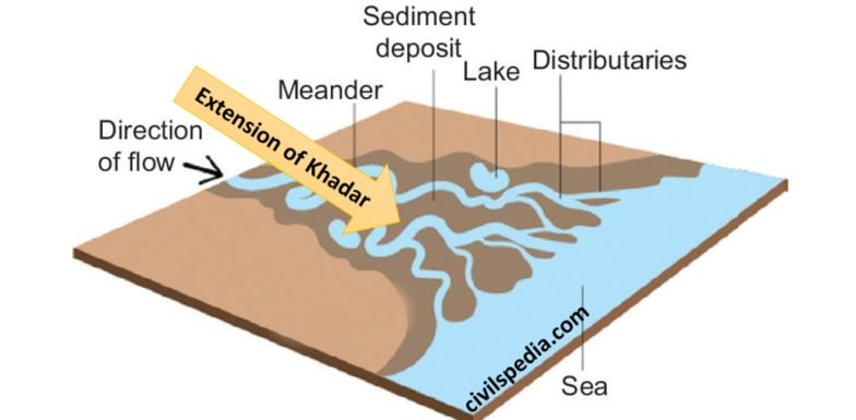
1.5 Deltas
- Deltaic Plains are the extension of Khadar Plains.
- Due to the sluggish river flow in this tract, it is an area of deposition.
- The deltaic plain consists of old mud, new mud and marsh.
1.6 Badlands
- In the north peninsular plateau and foothills of western Shivalik hills, due to gully erosion by the rivers, streams and rain, narrow valleys and ravines are formed, making land unfit for agriculture. Such plain areas are known as bad land.
2. Regional Division
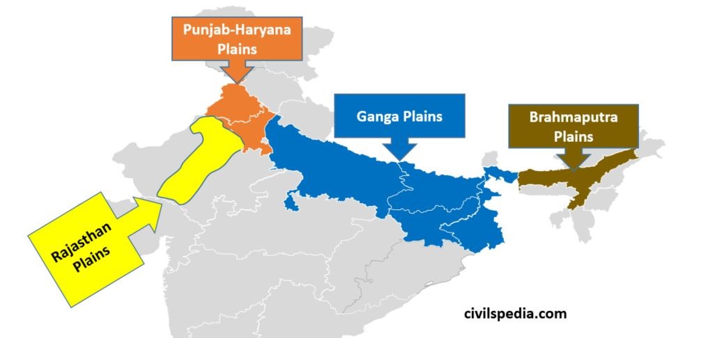
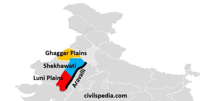
2.1 Rajasthan Plains
- Rajasthan plain lies to the west of the Aravalli range and is divided into two parts, i.e. Marusthali and Bagar. Bagar region is part of the Northern plains while Marusthali is desert.
- The Rajasthan plains slope toward the west and south.
- Rajasthan Bagar is a semi-arid region as it receives very less rainfall
- Rajasthan Bagar is further divided into three parts i.e.
- Luni: Region drained by river Luni and its tributaries
- Shekhawati Region: Region was ruled by Shekhawati Rajputs in the past.
- Ghaggar Plain: River Ghaggar, an inland river, drains and terminates in this region. This region has benefited from Indira Gandhi Canal carrying Punjab’s water to Rajasthan.
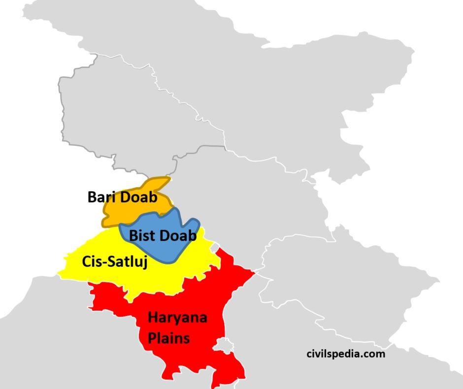
2.2 Punjab-Haryana Plains
- These are fluvial plains of Ravi, Beas and Sutlej (tributaries of Indus). A large part of this plain is now in Pakistan.
- The slope of this plain is towards the southwest.
- Punjab Plains has numerous seasonal rivers originating from the Shivaliks during the rainy season known as Choes. These rivers are responsible for the ravine and gully erosion.
- Delhi Ridge acts as the dividing line between the Indus River system (Punjab-Haryana Plains) and the Ganga River system.
- It has the following divisions.
- Bari Doab: Lie between Beas and Ravi rivers
- Bist Doab: Area between Beas and Satluj rivers
- Cis-Satluj / Malwa: Area of Punjab lying eastward of Malwa.
- Plain of Haryana: Area between Ghaggar & Yamuna consisting mainly of present-day Haryana state. It has a ‘saucer-shaped topography’.
- These plains are well irrigated but are now suffering problems due to over-irrigation leading to salination, over-use of fertilisers etc.
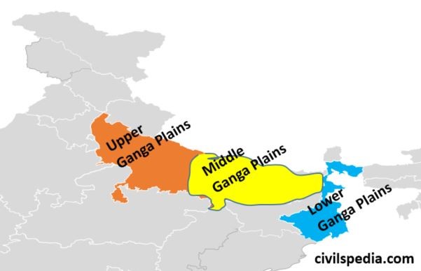
2.3 Gangetic Plains
- Gangetic Plains extends from the Yamuna River to Bangladesh.
- River Ganga and its tributaries constitute this plain by their sediments and make a great plain in India.
- It can be divided into three parts.
- Upper Ganga Plains: Also known as Ganga-Yamuna Doab as it consists of the area between Yamuna in the west and Ganga in the east. Awadh and Rohilkhand plains also lie in them.
- Middle Ganga Plains: Also known as the Bihar Plain or the Mithila Plain. It consists of the area between the Ghaghra River to Kosi River.
- Lower Ganga Plains: It is a flat deltaic region lying between the gap in the Rajmahal and the Garo hill ranges. It is located in the state of West Bengal and Bangladesh. Duars of the Terai tract are found in its north, and the world’s largest Sundarbans Delta is located in its southern parts.
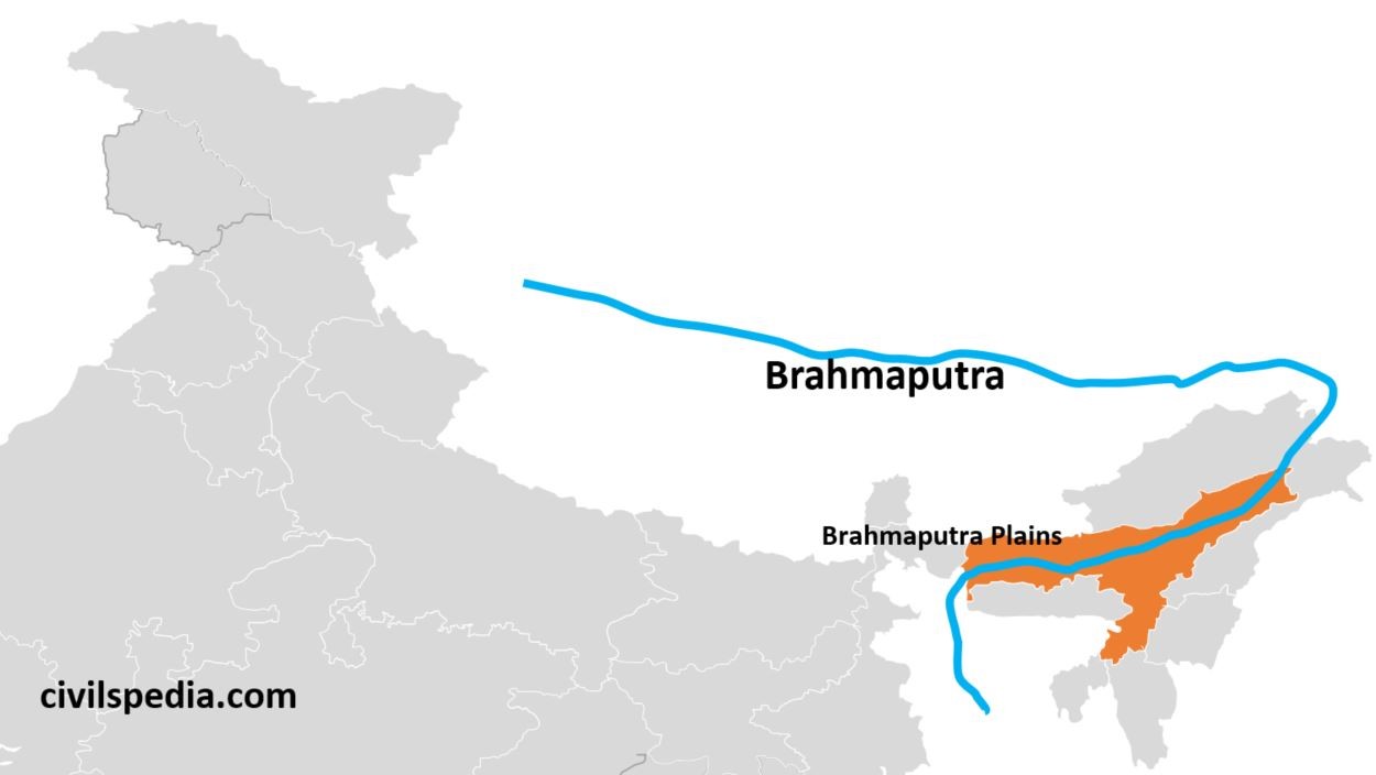
2.4 Brahmaputra Plains
- Brahmaputra Plains is also known as Assam Plains or Assam Valley.
- The Brahmaputra enters India as Dihang and debouches in the flat Assam region, where it is known as the Brahmaputra. On entering the Assam Valley, the speed of the river decreases, and it engages in a deposition which causes the river to shift its course and develop multiple channels. Such a river is called the ‘Braided River’. Brahmaputra River is highly braided and known for floods.
- There are numerous riverine islands, out of which Majauli Island is the largest riverine island in the world.
Importance of Northern Plains
- Granary of India
- It is a region of very fertile plains. Therefore, it is the most important agricultural region.
- Since it lies north of the Tropic of Cancer, Rabi and Kharif crops can be grown here.
- Due to perennial rivers and underground water, canals and tubewell irrigation are well developed here.
- Houses half of the Indian people
- Northern Plains houses more than 50% of India’s population in one-fourth of the geographical area of India .’
- Well developed Transportation
- Due to flat topography and high population density, road and rail density is highest in the Northern plains.
- Well-developed Food Processing Industry
- Because of well-developed agriculture, the food processing industry dominates in this region.
- Birthplace of Indian religions
- All the main religious movements, from Vedic Hinduism to Buddhism, Jainism and Sikhism, were born in the Northern Plains. Hence, the Northern plains represent the soul of India.