Table of Contents
The Peninsular Plateau
This article deals with ‘The Peninsular Plateau (Geomorphology of India).’ This is part of our series on ‘Geography’, which is an important pillar of the GS-1 syllabus. For more articles, you can click here.
Introduction
- Peninsular Plateau is the largest physiographic unit of India, stretching from Aravallis in the north-west to the Shillong plateau in the north-east and Kanyakumari in the south. It is triangular in shape.
- It occupies 50% of the Indian landmass, consisting of numerous small plateaus and mountains measuring around 16 lakh square km.
- It is an ancient tabular block containing Archean Gneiss, Schist and the Dharwar rock system. In the Deccan plateau, igneous Basalt rocks are also found.
- It is among India’s oldest and most stable landmass. It has undergone minimal structural changes since its formation. It has never been submerged beneath the sea except in the few places where marine transgressions have been made, and that too locally. Along with that, it has not experienced any tectonic activity except for Bhima Fault formed along the Bhima river.
- Due to old age, the rivers in this region attained their base level and developed broad and shallow valleys.
- Plateau’s general elevation is from west to east, also vouched by the river movement (except in the Narmada-Tapi rift valley).
It’s formation
- The entire peninsular plateau was formed during the pre-Cambrian era, i.e., 500 MYA (Million Years Ago).
- Later, the Indo-Australian plate (containing Peninsular Plateau) started to move towards the Eurasian plate. Around 70 MYA during the tertiary period, it passed over the Reunion hotspot, and highly fluid basaltic lava broke through the surface, forming a basalt flood province called Deccan Traps.
Division of Peninsular Plateau
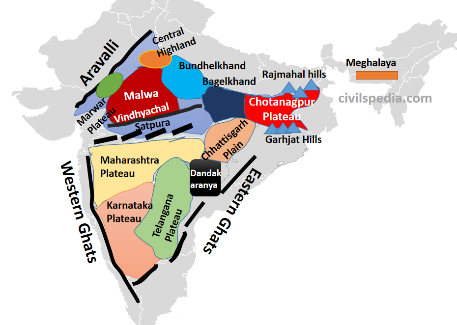
The entire Peninsular Plateau consists of several smaller plateaus and hill ranges.
| Plateaus | 1. Marwar Upland 2. Central Highland 3. Bundhelkhand Upland 4. Malwa Plateau 5. Baghelkhand 6. Chotanagpur Plateau 7. Meghalaya Plateau 8. Deccan Plateau 9. Chhattisgarh Plains |
| Hill Ranges | 1. Aravalli Range 2. Vindhya Range 3. Satpura Range 4. Western Ghats 5. Eastern Ghats |
1. Plateaus
1.1 Marwar Plateau
- Marwar Plateau is situated in eastern Rajasthan, east of the Aravalli mountain range.
- Average elevation varies between 250-500 meters above sea level.
- Marwar Plateau mainly consists of sandstone limestone and shale.
- It is a rolling plain due to erosional activities carried out by the Banas River. [‘Rolling plains’ aren’t flat, and there are slight rises & falls)
- The Peninsular plateau’s extension may be seen as far as Jaisalmer in the west, where sand dunes have covered it.
1.2 Malwa Plateau
- It lies in the north-western part of the Peninsular Plateau. It lies to the south-east of Aravallis and north of Vindhyachal Range.
- Chambal, Betwa and Ken drain the Malwa Plateau before joining the river Yamuna.
- It consists of an extensive lava flow, thus covered with black soils.
- It is devoid of vegetation, and due to gully erosion by rivers like Chambal, deep ravines have developed, and the region has been made unfit for agriculture, converting it into Badlands.
1.3 Bundhelkhand
- It is a part of the Peninsular Plateau, which extends east of the Malwa Plateau and is known as Bundelkhand.
- It lies in Madhya Pradesh & Uttar Pradesh.
- It has an average elevation of 300-600 m
- It is made up of Granite & Gneiss rocks.
- It is a drought-prone region.
- River streams such as Betwa and Ken flow through it. The erosional work of these rivers has converted this region into an undulating (wave-like) area.
1.4 Bagelkhand
- Bagelkhand lies to the east of Bundelkhand.
- It is made up of limestone and sandstone.
- It is drained by Son and Mahanadi rivers.
- The general elevation is between 150 m to 1,200 m.
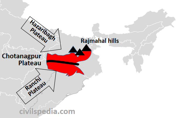
1.5 Chotanagpur Plateau
- It is the North-East projection of the Peninsular Plateau.
- It covers the state of Jharkhand & surrounding areas of Odisha, West Bengal, Chhattisgarh & Bihar.
- It is composed mainly of Gondwana rocks with patches of Archean Gneiss and Schist and Deccan Lava. Hence, it is rich in both metallic minerals as well as coal. 90% of India’s coal reserves are in this region, and hence it is called the ‘Ruhr of India’.
- River Damodar divides the Chotanagpur Plateau into two parts. The northern part is known as Hazaribagh Plateau, while the southern part is known as Ranchi Plateau.
- The North-Eastern edge of the Chotanagpur plateau is made up of Rajmahal hills. These are made up of basalt (lava flow). These hills have an elevation of up to 400 m.
- This region has a ‘Radial type of drainage‘. Following rivers originate and flow radially outwards from the Chotanagpur Plateau. The rivers include
- Damodar
- North Koel
- South Koel
- Subarnarekha
- Barkar
1.6 Chhattisgarh Plain
- The Chhattisgarh Plain is the only plain region in the Peninsular plateau that is worth naming.
- It lies between Maikal Range and Odisha Hills.
- It is saucer-shaped and is drained by the Mahanadi River.
- The general elevation is between 250-330 m.
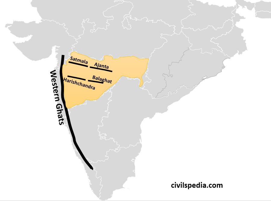
1.7 Deccan Lava Plateau
a. Maharashtra Plateau
- It lies in Maharashtra and forms the northern part of the Deccan Plateau.
- It is formed due to fissure eruption and lava flow. Hence, most of the rocks of this region are basaltic rocks of lava origin.
- It has ‘step-like topography‘ due to horizontal lava sheets. Hence, it is also known as ‘Deccan Traps.”
- Maharashtra Plateau has ‘Black Soil’, also known as ‘Regur’. It is well suited for the cultivation of Cotton.
- Important rivers of south India like Godavari, Bhima, Krishna, Vardha and Venganga flow through it. The erosional activity of these rivers has converted the region into a number of shallow and broad valleys flanked by flat-topped steep-sided hills and ridges. E.g., Godavari flows between Satmala and Balaghat.
b. Karnataka Plateau
- It lies to the south of the Maharashtra plateau.
- It is also known as Mysore Plateau.
- The general elevation is between 600-900 m.
- It is primarily made up of Archean formations.
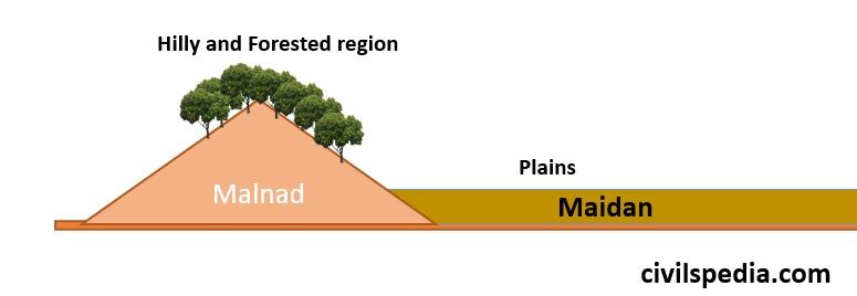
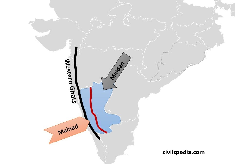
- Karnataka plateau has two parts, Malnad and Maidan.
- Malnad means ‘Hilly and Forested land.’
- Maidan means ‘plains’. It is a rolling plain made up of granite.
- The famous Baba Budan hills lie in the Malnad region, and it is renowned for its coffee plantation (the famous Café Coffee Day chain is based here).
- The region is highly dissected by the fast-moving rivers emerging from the Western Ghats.
- River Kaveri originates from the Malnad. It jumps from Malnad to Maidan to make the famous Shivsamudram Falls. Here, river Kaveri has two islands, i.e. Shivsamudram Island and Srirangapatnam Island (famous for the Treaty of Srirangapatnam). The lake between the two islands is known as Ranganathitoo Bird Sanctuary. Due to excessive water, the Shivsamudram region is famous for sugarcane.
- River Tungabhadra (a tributary of Krishna) also originates from the Malnad region.
c. Telangana and Rayalaseema Plateau
- It is made up of Archean Gneiss with an average elevation of 500-600 m.
- This region is semi-arid as it lies in the rain-shadow zone of the western and eastern ghats.
- It is a highly dissected region by the rivers passing through this region, i.e. Godavari, Krishna and Penneru.
d. Dandakaranya Plateau
- It is the mineral-rich region of Chhattisgarh and Odisha, touching parts of Maharashtra.
- It is drained by the Indravati river.
- Richest mines of India are found in Dandakaranya Plateau
- It is badly affected by naxalism and is a part of the ‘Red Corridor.’
1.8 Meghalaya Plateau
- It is the north-east extension of the Peninsular Plateau.
- It is separated from the Peninsular Plateau by Rajmahal -Garo Gap / Malda Gap. It is formed by the down-faulting, which was later filled by the sediments of river Ganga and its tributaries.
- This region is made up of Dharwar rocks of the Archean Rock System, shales and schists with granite intrusions.
- Coal, iron ore, sillimanite, limestone, uranium, and other minerals are abundant in the Meghalaya Plateau.
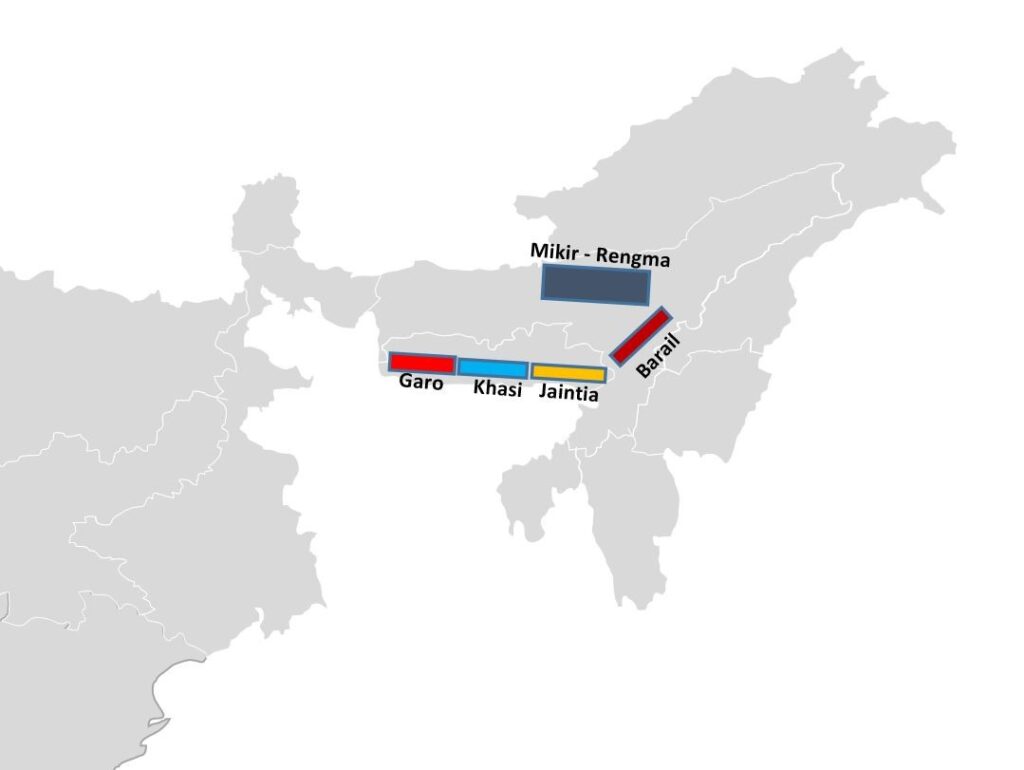
- The Meghalaya Plateau is divided into numerous hills such as Garo, Khasi, Jaintia, Barail and Mikir Rengma (Karbi-Anglong Plateau). Out of all, Khasi is the highest. Shillong, situated in the Khasi hills, is the highest point of the Meghalaya Plateau.
- This region receives ample rainfall from the south-west monsoon. The Meghalaya plateau has severely degraded as a result. Chirapunji exhibits a barren rocky surface devoid of any vegetation.
2. Mountains
2.1 Aravallis
- Aravallis are one of the oldest fold mountain ranges of the world which rose during the Precambrian event called Aravalli-Delhi orogeny. It is a classic example of the relic mountains that have been denuded now to form discontinuous ranges.
- Aravalli literally means ‘line of peaks’.
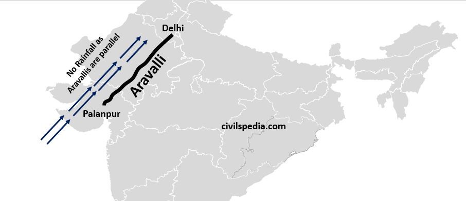
- These hills extend from Gujarat (Palanpur near Ahmedabad), through Rajasthan and Haryana, to Delhi in the north-westerly direction for a distance of about 700 km.
- Aravallis are a source of water for Sabarmati, Luni and Banas.
- The Great Boundary Fault separates Aravalli from Vindhya.
- It is facing erosion at great speed, and erosion is an environmental concern because it checks the spread of the Thar desert.
- The height of the Aravallis is greater in the south and reduces while moving from south to north. The height is about 1,500 m in the south-west, while near Delhi, the height is hardly 400 m. (Highest Peak= Guru Shikhar in Mt Abu is situated in southern Aravallis).
- Due to the direction of Aravallis from south-west to north-east, they don’t act as barrier to the Arabian Sea Branch of the South-West monsoon. Hence, the western part of Rajasthan is arid and semi-arid.
- Aravallis are rich in metallic minerals (Archean rocks) and marbles (Vindhyan sediments).
Issue: Erosion, Mining and Encroachment of Aravallis
- In the news, because of illegal mining and construction of illegal colonies and buildings in the Aravallis.
Significance of Aravallis
- Combating Desertification: It checks the spread of the Thar desert into the Great Plains.
- Water Divide: The Aravalli acts as a water divide between the Indus and Ganga river systems.
- Enhanced Precipitation: Aravallis enhances the precipitation in the area and checks drought.
- House of Biodiversity: The area is a rich habitat for biodiversity and houses 10 carnivore species.
- Aravallis are an important source of resources and minerals.
- Important drainage systems like the river Sabarmati and Luni originate from Aravallis.
Issues
- Deforestation: Supreme Court, in the matter of M C Mehta vs Union of India (2004), acknowledged that Aravallis are in a bad state due to illegal and unplanned deforestation.
- Mining: In the 2018 Judgement, Supreme Court commented that 31 out of 128 Aravalli hills in Rajasthan have disappeared due to illegal mining activities.
- Unplanned Urbanization: Due to rapid Urbanisation, illegal colonies are being cut in Aravallis, especially near the NCR region.
Outcome
- Desertification: Sand dunes are approaching the NCR region and parts of Gangetic plains due to the disappearance of effective barriers in the form of Aravallis.
- Pollution in Delhi: Supreme Court (2018), in its verdict, blamed the disappearance of the Aravalli Hills as one of the reasons for rising pollution in Delhi.
- Human-Animal Conflict: Instances of Human-Animal conflict have increased. For example, wild animals (like leopards) are venturing into human habitations in Gurgaon.
- Limited Seasonal Rain: Earlier, the hills accelerated seasonal rainfall in the nearby areas. The degradation in hills has decreased the amount of seasonal rainfall to a minimal, transforming land into a barren desert.
2.2 Vindhyachal Mountain Range
- It extends from Gujarat (Jobat) to Bihar (Sasaram).
- It has an average elevation of 450 to 600m.
- It is a BLOCK MOUNTAIN formed due to rifting. The southern boundary of the Malwa Plateau has escarped downwards due to faulting, and as a result, a block mountain and rift valley have formed. Vindhya is the block mountain (horst), while in the adjoining rift valley (graben), the Narmada river flows towards the west.
- Vindhyas act as the ‘Water divide of India.’
- It is a source of many north-flowing rivers like Chambal, Sindh, Betwa & Ken ( tributaries of Yamuna).
- It contains limestone and marble (property of the Vindhyan System of rocks).
- Kaimur Range is an extension of Vindhyas.
2.3 Satpuras
- Satpuras are a series of seven-block mountains (Sat = 7 and Pura = Mountains). It is not a continuous range in contrast to Vindhyas.
- They run in the west-to-east direction, starting from Rajpipla Hills (Gujarat) to Gawilgarh (Maharashtra), followed by Mahadev Hills (Madhya Pradesh)and ending with the Maikal Hills (Chhattisgarh).
- It runs through Gujarat, Maharashtra, Madhya Pradesh and Chhattisgarh.
- It forms the boundary between Maharashtra and Madhya Pradesh and between Maharashtra and Gujarat.
- Dhupgarh near Panchmarhi in Mahadeo Hills is the highest peak of Satpuras.
- Important rivers like Narmada, Son and Tapi originate from Satpuras.
- Narmada and Son originate from Amarkantak
- Tapi originates from a place known as ‘Multai’.
- Narmada flows in the rift valley between Vindhyas and Satpuras, while Tapi flows south of Satpuras.
- Both Narmada and Tapi are west-flowing rivers in contrast to all other peninsular rivers, which are east-flowing.
- Amarkantak, situated in the Maikal Hills of Satpura, is important as
- Rivers Narmada and Son originate here. It represents an example of ‘radial drainage’.
- Famous Amarkantak Biosphere Reserve (famous for Tigers) is situated here.
- Important fauna of the region includes Tigers, Elephants, Barasingha, Black Panther etc.
- Important tribes of the Satpuras include Khonds, Mundas and Bhils.
- It has great economic importance.
- Tropical Deciduous Forests of Satpura provide the best grade teak in the world apart from Sal and Tendu (minor forest produce).
- The paper industry of India is concentrated in this region. Vallabhgarh, which is the largest paper mill in Asia, is situated in this region.
2.4 Western Ghats
- The Western Ghats are Block mountains as the western coast of India has escarped downwards below the sea due to faulting.
- It runs continuously from Tapi Valley in Gujarat to Kanyakumari. But some passes are present in the Western Ghats.
- The average height is greater in the southern part than in the northern part.
- The western side of the Western Ghats is very steep, but the eastern part is gentle because of traps/ lava flow.
- Western Ghats are
- World Heritage Site declared by UNESCO
- Biodiversity Hotspot as declared by Conservation International
- Eco-Sensitive Zone declared under Environment Protection Act.
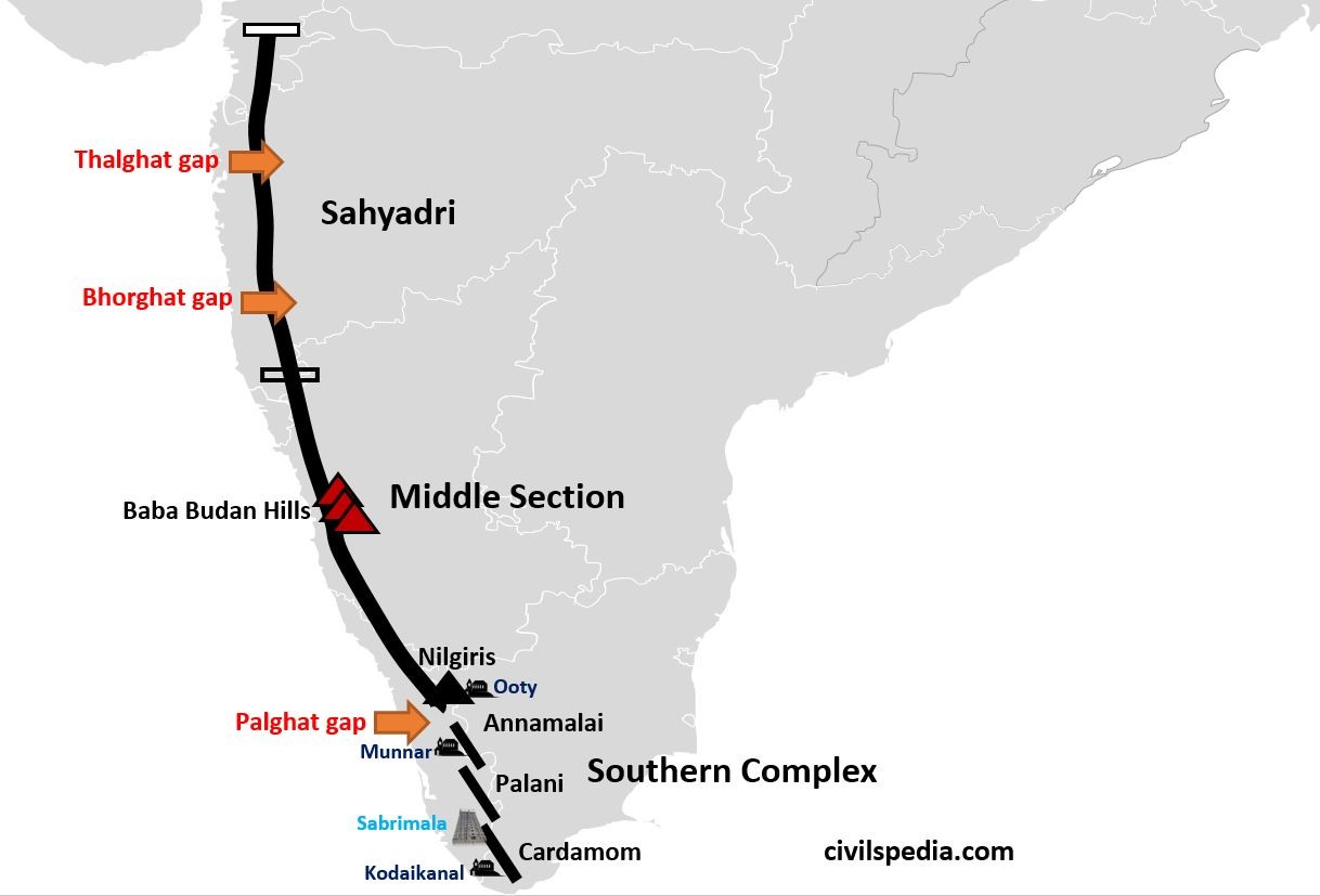
It can be subdivided into the following parts
1. Sahyadri
- The northern part of the Western Ghats, having a horizontal sheet of Deccan lavas, is known as Sahyadri.
- Mt Kalsubai is the highest peak in this region.
- Rivers such as Godavari, Bhima and Krishna originate from the Sahyadri ranges.
- There are two important gaps, i.e. Thalgat gap (connects Mumbai with Nashik) & Bhorghat gap (connects Mumbai with Pune).
2. Middle Section
- The middle section runs through Karnataka up to the Nilgiris.
- It is made up of granite and Gneiss presenting the rougher topography.
- The important peaks here are Baba Budan Hills.
- It is the source of the river Kaveri.
- Nilgiris, part of Western Ghats, forms the junction between Western and Eastern Ghats. This region is important as
- The important hill station, i.e. Ooty, is situated in Nilgiris.
- Nilgiris derive their name from a flowering plant, ‘Neel Kurunji,’ which grows in Shola forests in the Western Ghats.
- Nilgiri biosphere reserve is situated here. It consists of the region of Southern Karnataka, Tamil Nadu and Kerala.
- Nilgiri is famous for Rajiv Gandhi National Park (Kr), Bandipur National Park or Tiger Reserve, Talaimalai National Park, Wayanad Wildlife Sanctuary, Madumalai National Park, Silent Valley National Park (Kerala).
- Nilgiris have unique vegetation as in the lower reaches, Tropical Evergreen Forests are found, while in the higher reaches, Temperate Forests known as Shola Forests are found.
- Nilgiri Biosphere Reserve is also a junction of the Tropical Evergreen Forest (western Ghats) and Tropical Deciduous Forests at Satyamangalam National Park.
- Endemic Species of Nilgiris include Lion Tailed Macaque, Nilgiri Tahr, Malabar Giant Squirrel, and Malabar Civet.
- Nilgiris has a plantation of Coffee, Tea, Rubber etc. Due to plantation agriculture, there is an increase in Invasive Alien Species, especially Eucalyptus, Wattle and Lantana (Congress Grass) etc.
- Nilgiri is separated from the Southern Hill complex by Palghat Gap. Palghat Gap allows moist winds of South-west monsoon to penetrate to Mysore plateau. The Palghat gap is also a connecting link between Kerala and Tamil Nadu.
3. Southern Hill Complex
- It consists of Annamalai Hills, Palani Hills and Cardamom Hills.
- Anaimudi, situated in Annamalai hills, is the highest peak of the Peninsula. It is famous for Indira Gandhi Tiger Reserve. It is also known as Topslip.
- Famous hill stations, like Munnar in Annamalai Hills and Kodaikanal in Palani Hills, are also situated here.
- Cardamom Hills is the southernmost branch, and it is famous for spices.
- The famous Sabarimala Temple lies in the Cardamom hills.
2.5 Eastern Ghats
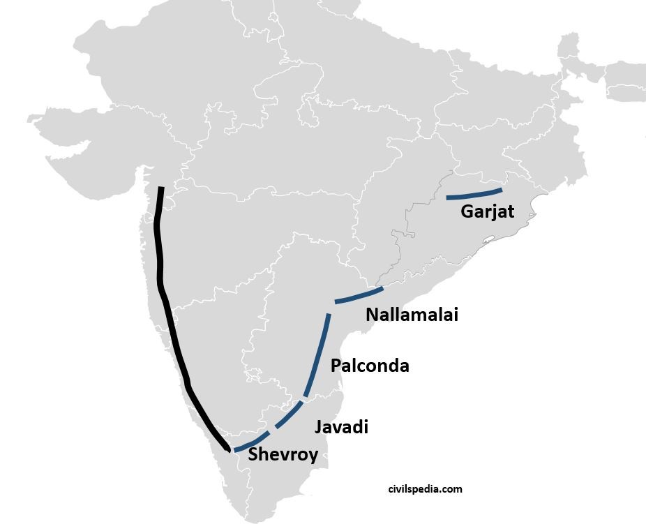
- The Eastern Ghats are a series of discontinuous hills starting from the Vaigai river in Tamil Nadu to the Mahanadi River in Odisha.
- There is no structural and geological homogeneity. All the hills have formed in different geological events.
- Eastern Ghats consists of (from south to north)
- Shevaroy and Javadi in Tamil Nadu
- Palconda and Nallamalai in Andhra Pradesh
- Garjat in Odisha
- They are cut by four major rivers of South India, i.e. Godavari, Krishna, Kaveri & Mahanadi.
- Eastern Ghats are much older than Western Ghats.
- They are not as high as the Western Ghats.
- The highest peak of Eastern Ghats is Mahendragiri (in Garjat Hills)
- They receive lesser rainfall than the Western Ghats. Hence, the vegetation of this region is Tropical Deciduous.
wow!!!!!!!!!!!!!!!!!!!!!!!!!!!!!!!!! such a detailed explanation and i understood it
Thank you. And spread the word about our initiative