This article deals with ‘Plains.’ This is part of our series on ‘Geography’ which is important pillar of GS-1 syllabus . For more articles , you can click here
Introduction
Plain is an extensive tract of
flat and or a gently undulating terrain without prominent hills or
depressions.
They are formed both by
internal forces of the Earth and by external processes of aggradation and
degradation.
They range in size from very
small to a very large areas.
The great centres
of population of the world are on plains. Development of means of
communications and transportation facilities is easier in the plains. Hence, these are
best known areas for human habitation.
Types of Plains
Plains are best classified according to their origin
1 . Diastrophic Plains
Plains formed on regions that
were once submerged under ocean or sea.
Example : Great plains of
U.S.A which extend till Canada were
formed due to upliftment submerged landmasses under epicontinental
seas and were uplifted at the end of Cretaceous period to due tectonic
movements . They have deposits of horizontal thick beds of Marine
sediments
2. Peneplains
Undulating surface of low relief, interspersed with
occasional residual hills and claimed to have been formed due to erosion
by rivers and rain.
Example include East Central
Africa
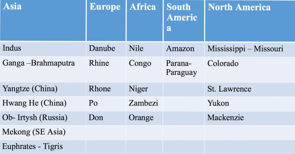
3. Flood Plains
Flood Plain is that part of
river valley adjacent to the channel, over which a river flows in times of
floods.
Floodplain is composed of
Alluvium
Examples : Indo-Gangetic plain
and the plains of Mississippi, Amazon, Nile, Hwang-Ho, Yangtze Ob, , Lena,
Volga rivers
4. Delta Plains
As rivers draw near seas to
disappear in them, their flow goes dead slow. It necessities the waters to
deposit all types of materials being carried by it. Such depositions are
made in triangular shape which resembles to Greek word ‘Delta’.
These plains are the most
fertile plains of the world.
Examples : Sundarbans of Ganga
and Brahmaputra, Deltas of Nile and Mississippi etc.
5. Aeolian Plains
Aeolian plains are plains formed by either erosive or depositional action of winds
Examples
Sahara and Thar
Plains formed by filling of lakes in Kashmir and Manitoba (Canada)
Lava plains of Idaho (U.S.A.)
Plains of Mecca & Medina
Importance of Plains
Plains are the ‘cradles of
civilizations’ and the ‘food baskets’ of the world with 80% of population
living in plains, i.e., Prairies (U.S.A), Steppes, Pustaz (Europe), Veld
(South Africa), Great Indo-Gangetic Plains of India, Downs (Australia),
Canterbury plains of New Zealand
Undulating and fertile land of
plains is beneficial for conducting agricultural activities and irrigation
Developing means of transport
like building roads, lying railways, preparing air strips etc. is easy in plains.
Industry and other commercial
activities are more easy to be carried out in plains.
This article deals with ‘Mountains.’ This is part of our series on ‘Geography’ which is important pillar of GS-1 syllabus . For more articles , you can click here
Folding and Faulting
Process of mountain formation involves concepts of Folding and Faulting. Hence, we will first learn about these concepts.
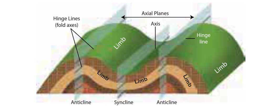
1 . Folding
Folding is the bending of
rock strata due to compression.
Folding on a large
scale results in mountain building referred to as orogeny
Up thrown part of a fold is
called anticline. Down thrown part of a fold
is syncline. The side of the fold is a limb
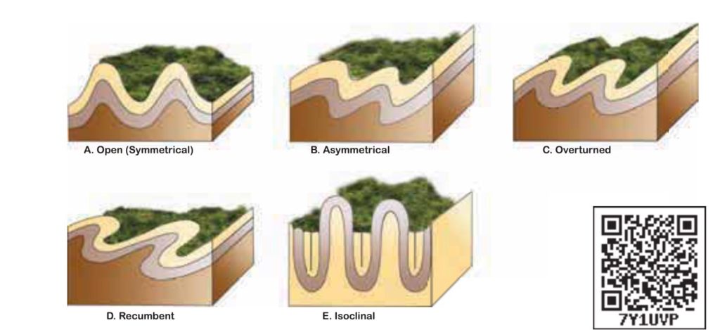
Types of folding
Symmetrical fold
When compressional force is equal from both sides, the angle of the limb is same on both sides.
Asymmetrical
fold
When compressional force is more from one end, one limb is steeper than the other.
Isoclinal
folds
similar
to symmetrical folds, but these folds both have the same angle and are
parallel to each other
Over
turned fold
When one
limb of the fold is pushed over the other limb of the fold, it is called as
over turned fold.
Recumbent
fold
When one
side of the fold is pushed so much that it lies positioned over the other
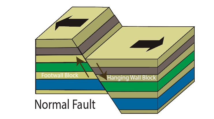
2. Faulting
A fault is a break in earth’s crust where blocks of rock crust slide past each other.
Types of Faults
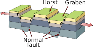
2.1 Normal Fault
Vertical displacement of the
crust is called a normal fault.
Normal fault is caused by
tensional forces where plates diverge.
One block lies above and other block lies below the fault
Landforms made by Normal fault are:
Rift Valley or Graben : When a narrow block of land drops or subsides between two parallel normal faults, rift valley (Graben) is formed. Eg : River Rhine Rift valley between Black Forest and Vosges, Narmada Rift Valley between Satpura and Vindhya and Great African Rift Valley
Horst : When a block of land between two faults is pushed up, block mountain or horst is formed. In this case, the central block is not only up thrown but the side blocks are also relatively downthrown . Eg : Mountains Vindhya and Satpura.
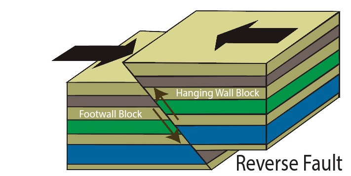
2.2. Reverse Fault
Reverse fault is a horizontal displacement of the crust.
It is caused by compressional forces
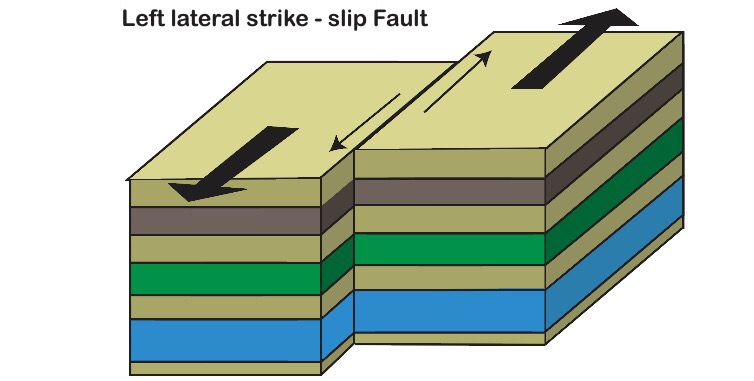
2.3 Shear Fault
It is
created by shearing along transform boundaries. Rocks on either side of fault
slip past each other sideways with little up or down motion
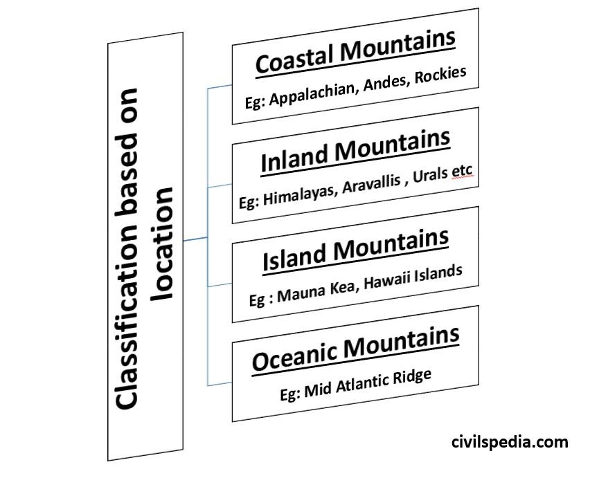
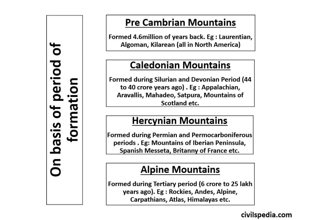
Classification of Mountain Ranges of the world
Mountains can be categorised in different ways
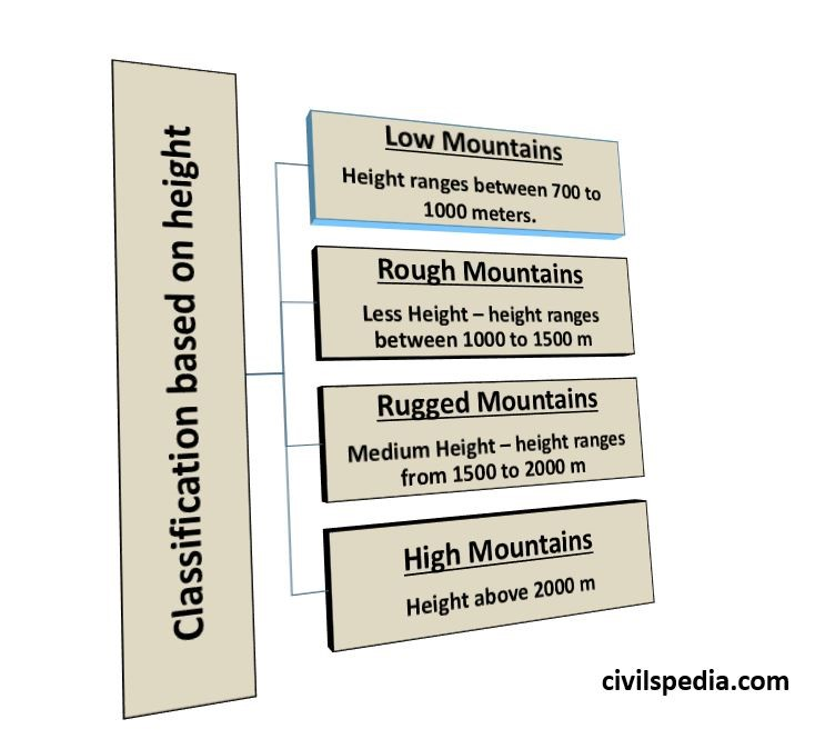
1 . Classification of Mountains on the basis of height
2. Classification on basis of location
3. On basis of period of formation
We
have to note the fact that Mountains are born &
have finite life span like
Young
mountains
High,
steep & growing upward (like
Himalayas and other Alpine mountains).
Middle
aged mountains
Cut by erosion
Old
mountains
Deeply eroded & often buried (like Aravalli, Appalachians etc)
Types of Mountains on basis of formation
Based on difference in process of their formation, there are following types of mountains :-
Fold Mountains
Bock Mountains
Volcanic Mountains
Domed Mountains
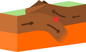
1 . Fold Mountains
Folded mountains are formed due to folding of crustal rocks by compressive forces generated by the convergence of tectonic plates. Eg :
Convergence of Indo-Australian
and Eurasian plate leads to the formation of Himalayas.
Convergence of American and
Pacific plate leads to formation of Rockies
Convergence of South American
and Nazca plate leads to formation Andes
Process of their formation is known as Orogeny. It is not a continuously happening process in the geological past but it happens intermittently. In whole of the geological past, total 9 Orogenies have happened of which last four are important for us
Pre-Cambrian
Orogeny ( Laurentian , Algoma etc)
Caledonian (Aravallis,
Appalachian etc )
Hercynian Orogeny
(mountains include Mountains of Iberian Peninsula, Spanish Messeta
etc )
Alpine Orogeny (they are the
youngest and are still rising. Mountains include Andes, Rockies,
Himalayas, Alps, Atlas etc)
Characteristics of Fold Mountains
Extensive mountain chain
spread over large area .
They are of great height .
Formed along unstable parts of
earth and plates are active there . Hence, earthquakes are quite common in
this region.
Sedimentary
deposits of marine origin are also found in this .
Fold Mountains also have age –
Himalayas are one of the youngest ranges & that is why they are so high .
Aravalli is one of oldest mountain range . After million of years Aravalli is still standing , this vouches for its great heights during youthful stage ( which might be even higher than Himalayas )
Side Topic : Phases in formation of Mountain Ranges
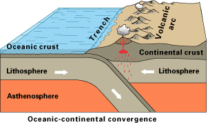
1st Stage : Oceanic-Continental Collision
Convergence of Ocean &
Continental Plate.
This will lead to formation of
mountains on the Continent-Ocean margin.
Examples include Andes
Mountain at convergence of Nazca and South American plate.
2nd Stage : Development of Geo-Syncline
This is developed between
Mountains & Trench .
In this , sediments from
river as well as from ocean keep on accumulating
And geo-syncline is formed
3rd Stage : Continental -Continental Collision
Ultimately whole of ocean plate will be subsumed .
Then continental continental plates will collide and compressive forces cause folding of Continental Crust along with squeezing and folding of sediments and material at the Geo-Syncline (reason why Marine Sediments are found in Fold mountains)
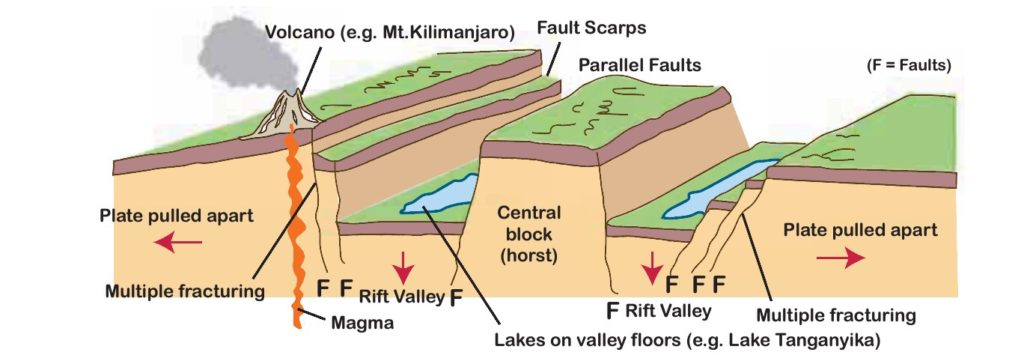
2. Block Mountains
Block mountains
are formed due to faulting in the ground surface. In this case, the
central block is not only up thrown but the side blocks are also
relatively downthrown
Block Mountains represent the Horst with Rift valley or Graben on either sides.
Examples include
Sierra Nevada mountains of California (USA)
Salt range of Pakistan,
Rhine rift valley in Europe
Vindhya and Satpura in India
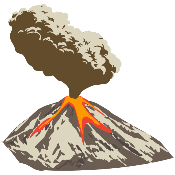
3. Volcanic Mountains
Volcanic Mountains are formed
due to Volcanic Activities
Examples include Mount
Kilimanjaro in Africa, Mount Fujiyama etc
They are formed
with the consolidation of Andesitic
magma coming out of earth’s crust
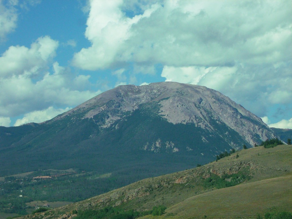
4. Upwarped (domed) Mountains
Formed by upwarding of surface due to pressure on
crust from below
Example : Adirondack
mountains of New York.
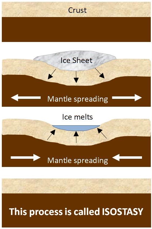
Side Topic : Isostasy
It is seen that heavily snow covered glacial regions
in the Polar belts (eg Norway, Greenland) tend to rise up over long period with
the melting of the snow (rebound). Why?
Isostasy
is the phenomenon of rebound of the earth’s crust in regions where elevation is reduced
due to degradation and relative erosive processes. Here , the rebound
compensates reduction in height
Since,
Tectonic Plate is floating on Asthenosphere , when mountain is eroded or snow
melts there is lowering of mass and hence rebounding of the tectonic plate
upwards happen
Importance of Mountains
Mountains
cover 27% of earth’s continents and 20% of population resides here making
it an important part of human civilization
Mountains are great source of
resources like Hydroelectricity, Wood, Medicinal plants, wild
animals/insects, fruits etc.
Most of the perennial rivers
of the world originate in mountains like Ganga, Brahmaputra, Rhine, Hwang
Ho , etc. Human civilizations were
made possible by the rivers originating in mountains since most of the old
civilizations like Indus valley civilization, Mesopotamian Civilisation
(Euphrates) , Egyptian Civilization (Nile) etc flourished on the banks of
these rivers
Mountains are source of
attraction for tourism related activities. Large number of people visit
mountainous regions as tourists and also helps in generation of employment
in those regions.
They have religious and
cultural significance as well. For example, Himalayas are abode to many
Hindu gods like Shiva.
Mountains have their lasting
effect over climate of any region. In India, the Himalayas contribute very
importantly for rainfall not only through Monsoon winds but through
cyclones also.
This article deals with ‘Earthquakes .’ This is part of our series on ‘Geography’ which is important pillar of GS-1 syllabus . For more articles , you can click here
Introduction
Sudden release of energy in Earth’s crust, which leads to series of motions due to waves created by the released energy is called Earthquake. Hence , it is nothing but release of energy.
Terminology
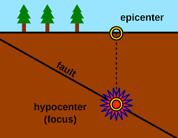
Hypocentre/
Focus
Point
inside surface where earthquake is generated by first rock displacement &
fault is created.
Epicentre
Point on earths surface
which is directly above hypocentre.
Most destruction occurs
here.
Earthquakes occur in three forms of clusters
Foreshocks
Occur
before a larger one at same location.
Mainshocks
Are of
highest magnitude & occur within an hour of foreshock.
Aftershocks
Are
smaller quakes that occur at same general geographic location for days &
even years after the larger main shock
Types of Earthquake
1 . Types based on causes
a. Tectonic Earthquake
Most common type are the
tectonic earthquakes.
These are generated due to
sliding of rocks along a fault plane.
b. Volcanic Earthquake
Due to volcanic eruption.
But confined to areas having active volcanoes .
c. Collapse Earthquakes
In the areas of intense mining activity, sometimes the roofs of underground mines collapse causing minor tremors.
d. Explosion Earthquake
Ground shaking may also occur due to the explosion of chemical or nuclear devices.
e. Human Induced Earthquake
Earthquakes that occur due to human activities
Reservoir induced seismicity
Mining related seismicity
Groundwater extraction related earthquake
Types on basis of depth
a. Shallow focus
Hypocentre is upto 70 km
Not felt
away from epicentre
Cause maximum destruction in
the region near epicentre (energy released is close to surface)
b. Medium focus
Hypocentre is from 70 to 300 km
Distance of impact and
destruction potential between deep focus and shallow focus.
c. Deep Focus
Hypocentre is below 300 km
Felt upto large distance from
epicentre
Cause low destruction
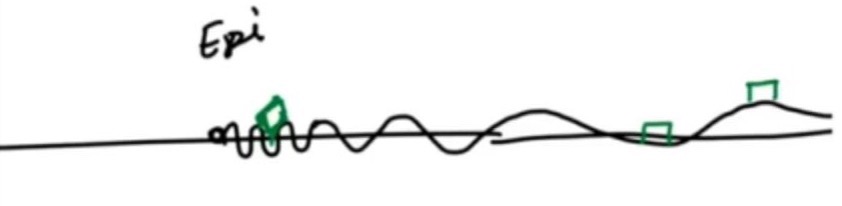
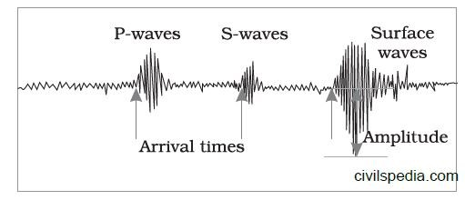
Side Topic : Why maximum destruction is near the epicentre?
As one
moves away from the epicentre, wavelength of surface wave will increase. Hence,
building situated near the epicentre will fall on both crest and trough of wave
causing building to collapse while building situated away from the epicentre
will either fall entirely on crest or trough not doing much damage.
Effects of Earthquake
Earthquake
is a natural hazard. The following are the immediate hazardous effects of
earthquake:
Ground Shaking
Land and mud slides.
Soil liquefaction.
Ground lurching .
Avalanches.
Ground displacement
Floods from dam and levee failures .
Fires.
Structural collapse.
Falling objects
Tsunami.
Change in course of river
Human and property loss
Cracks in building
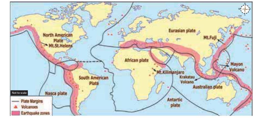
Earthquake Belts in World
Three major earthquake belts in this world :-
a. Circum-Pacific Belt
Along a patch surrounding the Pacific ocean
Region of great
seismic activity eg Japan, Philippines, Chile etc lies here
Coincides with Pacific Ring
of Fire.
b. Alpine Himalayan Belt
Runs through
mountainous region that flank Mediterranean Sea extend through Iran &
Himalayan mountains
Frequent & destructive
earthquakes occur here.
c. Other areas
Northern Africa
Rift Valley areas of the Red
Sea and the Dead Sea.
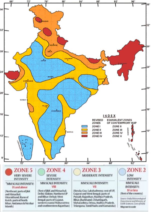
Earthquakes In India
India has high frequency of great earthquakes (greater than 8.0) .
Reason
Tectonic setting of India .
Indian plate is moving at a
speed of one cm/ year towards
the north & north-eastern direction and this movement of plates is being
constantly obstructed by the Eurasian plate from the north. As a result of
this, both the plates are said to be locked with each other resulting in accumulation of energy . Excessive accumulation of energy results
in building up of stress, which ultimately leads to the breaking up of the
lock & sudden release of energy causing earthquake
Region has remained seismically quiet for more than
600-700 years => enormous buildup of strain => Earthquake of magnitude
8.5 or more can hit region in near future
Some Great Earthquakes occurred in India.
1819:Gujarat
8.3
1897:Assam
8.7
Extensive
liquefaction in alleviated plains of Brahmaputra.
1934:Bihar-Nepal
8.4
Extensive
liquefaction —-> buildings tilted & slumped bodily into ground.
1967:Koyna
6.5
– 1962 —-> Koyna Dam built —> earlier area was aseismic but after this seismic activity increased—-> dam induced earthquake – Revision of Indian Seismic was done and in Zone map, Koyana was moved from Zone I to zone IV & Bombay to Zone III.
Question : What are the reasons for occurrence of earthquakes in geologically inactive regions like Peninsular India ?
It is possible that collision of
Indian and Eurasian plate has generated stresses not only at boundaries
but also inside plate. As a result zones of weakness have formed on the plate. There is possible breaking up of Indian
plate, which is most evident along
river Bhima near Latur and Osmanabad, regions experiencing disturbances in the past.
Peninsular India is home to some grand dams and reservoirs which have resulted in
reservoir induced earthquakes (eg. Koyna Dam).
Measuring the Earthquake
The earthquake events are
scaled either according to the magnitude or intensity of the
shock.
The magnitude
scale is known as the Richter scale. The magnitude relates to the energy released during the quake. The magnitude is expressed in
absolute numbers, 0-10.
The intensity
scale is named after Mercalli, an Italian seismologist. The intensity
scale takes into account the visible
damage caused by the event. The range of intensity scale is from 1-12.
1 . Richter Scale
Concept of Earthquake
magnitude was developed by Richter who invented Richter scale .
It is Base 10 logarithmic
scale obtained by calculating logarithm of shaking amplitude of largest displacement from zero Anderson
Torsion seismometer at 100 kms from epicenter.
Increase in 1 means 10 times
more shaking amplitude.
Earthquakes with magnitude
more than 6 are destructive
2. Mercalli Scale
Intensity scale is named after Mercalli, an Italian seismologist.
Intensity scale takes into account the visible damage caused by the event.
The range of intensity scale is from 1-12.
Side Topic: Shindo scale
Known as Japanese
Meteorological Agency(JMA) seismic intensity scale.
Used in Japan & Taiwan.
JMA scale tells us about
degree of shaking at a point on earths surface .
Ranges between Shindo 0(no
shaking) to Shindo 7(most
devastating).
Same earthquake has different
Shindo number at different locations.
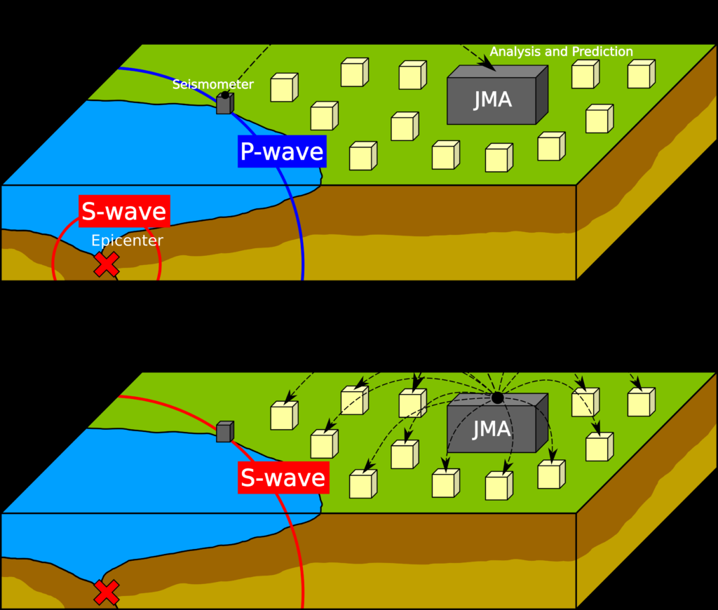
EARTHQUAKE EARLY WARNING SYSTEM
Earthquake Early warning system will issue warnings 1-40 seconds before earthquakes
Based on detection of waves generated during an earthquake.
P wave is harmless but travels faster than the Surface and S waves which cause maximum destruction
This system works on detection of P wave for advance warning.
Ocean Currents, Waves, Tides and Thermo-Haline Circulations
This article deals with ‘Oceanography: Ocean Currents, Waves, Tides and Thermo-Haline Circulations.’ This is part of our series on ‘Geography’ which is important pillar of GS-1 syllabus . For more articles , you canclick here
Introduction
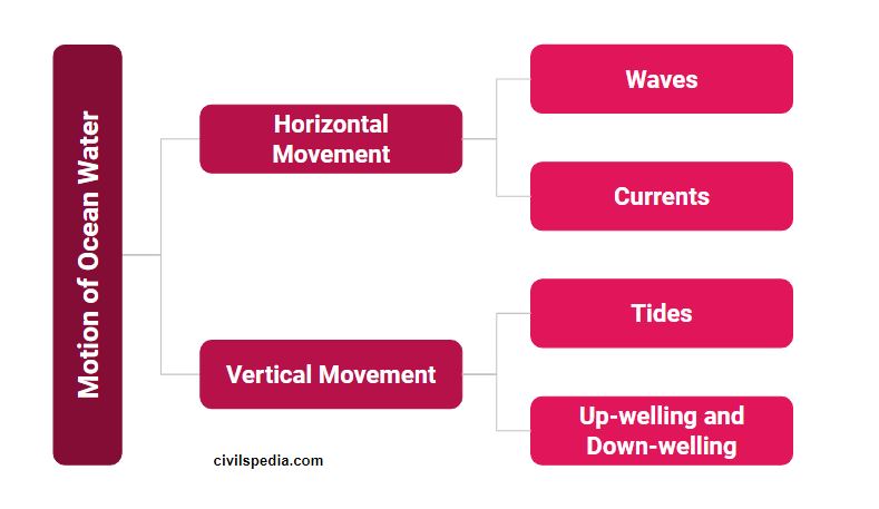
Major movements of ocean water can be categorised as follows:-
1 . Horizontal Movement : Waves
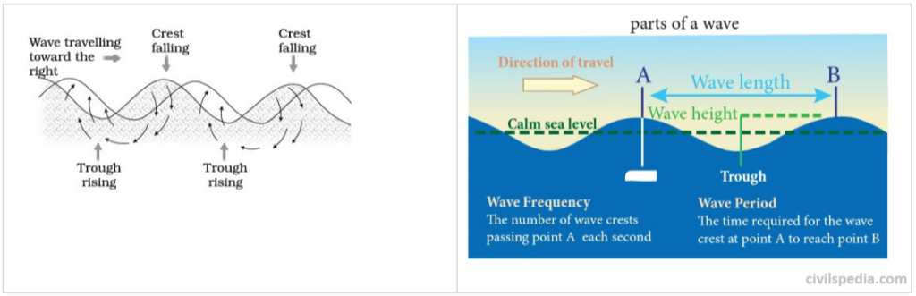
The waves
are oscillating movements in the ocean water which transfer energy from place
to place.
Creation of waves
Wind pushes (away) the water
body & creates crest.
Gravity pulls the crest
downward & falling water pushes the former troughs upward .
Actual motion of water beneath wave is circular (& not straight) & while we go downward movement of
water molecules keep on decreasing.
Hence, in waves very slow
horizontal movement of water takes
place .
Waves actually involves the transfer of energy and water particles don’t move across the sea/ocean as
such. Water particles only moves in circular pattern as wave passes. Wind
causes waves to travel in ocean and energy is released at the shore.
2 . Horizontal Movement : Currents
Large mass of moving water from one part of the ocean to another in a definite direction is called as ocean current.
The movement is produced due to earth’s rotation, temperature difference of ocean water, salinity, density , air pressure and winds.
They circumnavigate the earth .
What Currents do
Heat re-distribution – from Equator to Poles.
warm water from equator to poles .
cold water from poles to equator.
Factors responsible for ocean current
The primary forces that influence the currents are:–
a. Wind
Most dominated force.
In most cases, direction of
wind will be direction of underlying current .
b. Insolation
Heating by solar energy cause
the water to expand. That is why, near equator the ocean water is about 8 cm
higher in level
than in the middle latitudes.
This causes a very slight gradient and water tends to
flow down the slope.
c. Salinity
Water will move from lower
salinity to higher salinity on the surface .
Reason : Water with higher
salinity being denser sinks & as a result water with low salinity
comes to fill the space.
Eg : Water from
Atlantic flows to Mediterranean
d. Coriolis Force
Coriolis
Effect : Due to rotation of earth – West to East .
Object moving in Northern Hemisphere will deflect Clockwise
Object moving in Southern Hemisphere will deflect Anti Clockwise
Movement of currents should be straight from equator to pole but not straight because
Coastline modifies the path.
Coriolis force
Nomenclature : Warm Current & Cold Current
Warm current is one that carry water
warmer than water found at that latitude .
Water flowing from low
latitude to higher latitude is warm.
Currents effect climate of bordering landmass eg wind blowing to
land from warm current cause rainfall. This is the reason why
mostly east coasts of continents receive rainfall & west coasts are
deserts.
General Pattern of Currents in all Oceans
Due to rotation of earth from west to east , two currents one on each side of equator are formed called North & South Equatorial Current.
Water carried in form of Equatorial currents tend to accumulate in western part of ocean or eastern coast of continent.
To balance this Counter Equatorial Current is formed between two Equatorial Currents from West to East.
Water at eastern coast of continent start piling up & under influence of density gradient start moving towards middle latitudes
At same time high density water at poles start flowing towards equator in form of currents along eastern coast of continent & two meet in middle latitudes where cold water sinks & warm water spreads on it .
The water is pushed towards east by strong westerlies & water reaches eastern part of ocean or western coast of other continent.
Obstruction at western part of continent divides water & one moves toward pole & other toward equator.
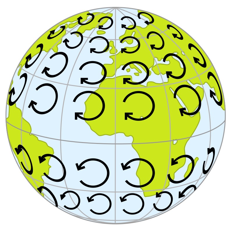
The water sinked in middle latitude upwells along the western coast to make good removal of water at equator . As a result circulatory cells known as gyres are formed one in each major ocean basin & is situated between 20 to 30 degree in both hemisphere.
This system is found in all oceans except Indian ocean where major changes occur due to presence of Indian peninsula & seasonal reversal of winds producing double gyre moving in seasonally opposite directions.
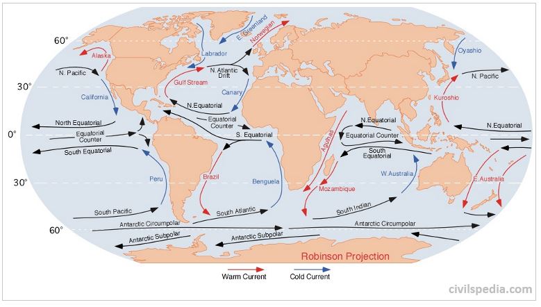
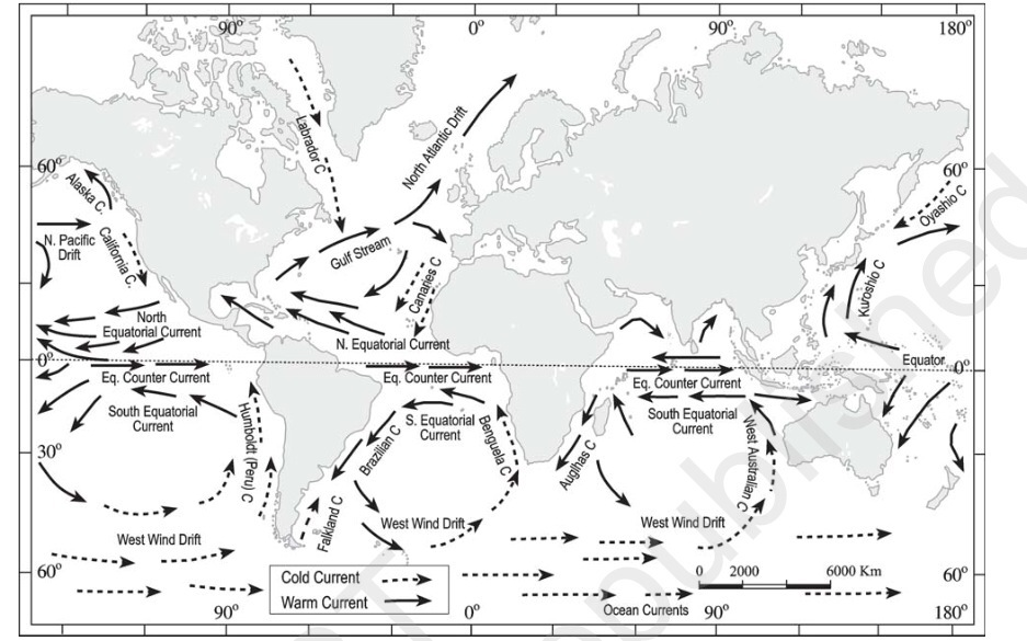
2.1 Currents in Atlantic Ocean
Warm Currents in Atlantic Ocean
a. North Equatorial Current
North equatorial current flows
from east to west between 5– 20 N latitudes.
After leaving the west coast
of Africa, it attains its main characteristics.
When it reaches the east coast
of South America, it splits into two branches and one branch called
Antilles current moves along the coast of West Indies and other branch is
diverted into the Caribbean sea.
b. South Equatorial current
It flows south of equator within 0 – 12 S
latitude in between the coast of Africa and South America.
It is stronger than the North
equatorial ocean current
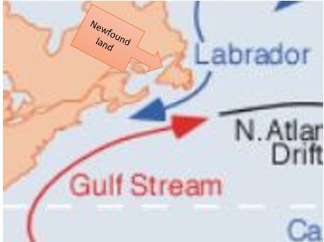
c. Gulf Stream
Gulf Stream starts from the
Gulf of Mexico and carries warm waters into the colder latitudes.
It bends with the coastline up
to 40th parallel after which the direction is almost to the east, due to
the force and the direction of the westerlies and the deflective force of
the earth.
It joins the Labrador cold
current near New Found land, Canada
making it a good fishing ground.
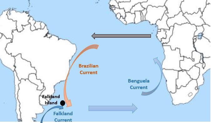
d. Brazil Current
Warm current moving south
along the coast of Brazil.
It joins the Falkland cold
current near Bahia Blanca making it
a good fishing ground.
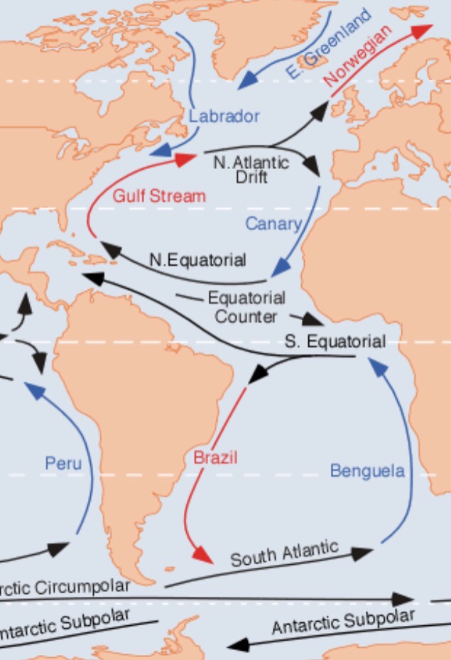
e. Norwegian Current /North Atlantic Drift
Norwegian Current takes warm water towards the coast of Norway allowing it’s coast to be operational throughout the year.
Cold Currents of Atlantic Ocean
a. Canary Island
It flows south along the Western coast of North Africa
between Maderia and Cape verde
Gradually , it merges with the
North equatorial current.
b. Labrador Current
In the north Atlantic, it
flows from the Baffin Bay and Davis Strait towards south.
It brings cold waters from polar zone and
moves along the coast of green land.
It meets with warm Gulf Stream
near New Found Land making it a good fishing ground.
c. Benguela Current
It flows northward along the
western coast of Africa
It carries cold waters from
sub-Antarctica surface water and mixes with south equatorial current
Side note : Newfound Land Island
Meeting point of Gulf Stream( warm current) & Labrador current (cold Current)
Amount of planktons increases resulting in large number of fishes. Hence, it is Good fishing ground.
Side Note: North Atlantic Drift / Norwegian Current
It provides warming effect to
western Europe.
Due to this, ports of Norway
– Narvik, Hammerfest , Murmansk etc keep on operating in
winter but at same latitude ports in Russia freeze during winter .
Side Note : Canary Current and Sahara Desert
Canary current is cold
current(passes near Canary Islands).
They give desiccating effect
(drying effect) to Sahara Desert resulting in no rainfall .
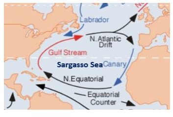
Side Note : Sargasso Sea
It is the only sea in the world without a land boundary. Its boundaries are defined only by ocean
currents. It is encircled by the Gulf
Stream in the west, north Atlantic drift in the north, Canary current in
the east and North Equatorial and Antilles current in the south
Due to confinement , Sargassum ie a sea weed grow in this region which obstructs
navigation. Plants have become adapted to life in the open sea, need no
roots or holdfasts for attachment, and are able to propagate by breaking
off bits to grow into new plants through vegetative propagation.
It is very saline. Reasons for this are
Prevention of mixing of fresh
water from surrounding oceans due to virtual boundary created by the
ocean currents.
High Evaporation due to high
temperature owing to its subtropical location
Gulf Stream brings in high
salinity water to the sea.
It is devoid of nutrients
& hence, poor marine life .
Side Note : Bahia Blanca & Falkland Island
Meeting point of warm Brazilian & cold Falkland Current .
Important for fishing
activity.
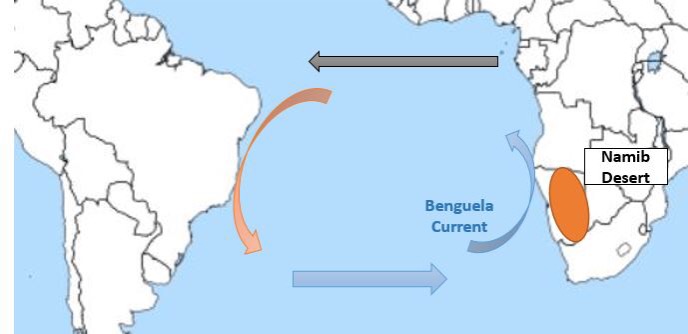
Side Note : Benguela Current & Namib Desert
Benguela Current is a Cold Current.
It gives desiccating effect leading to low rainfall on the south-west coast of Africa and formation of Namib Desert.
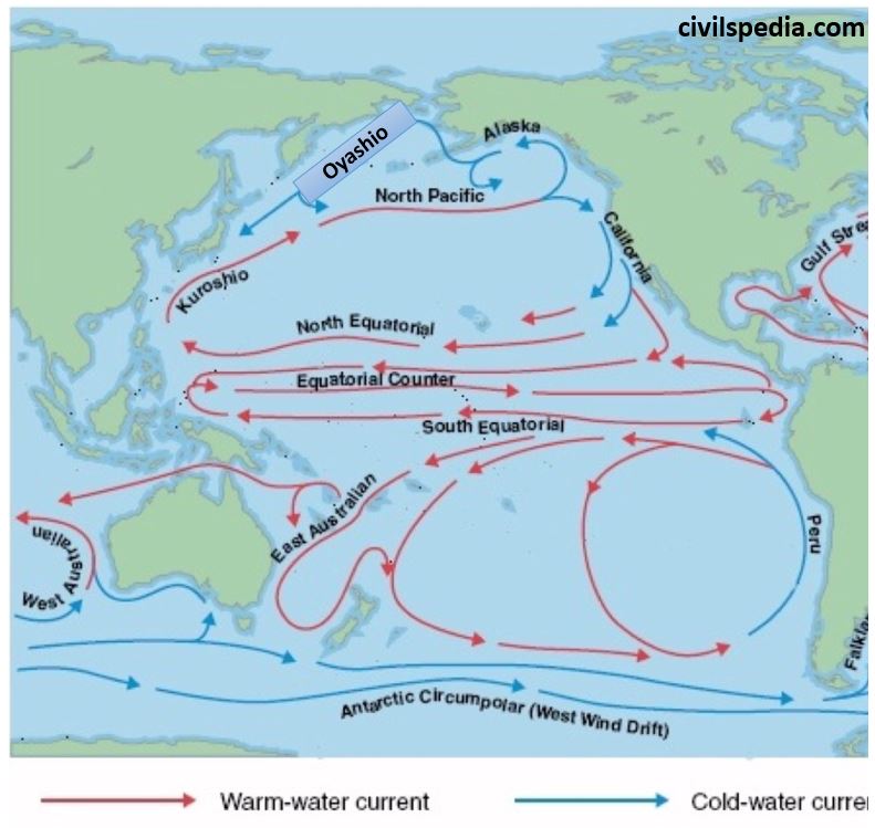
2.2 Currents of Pacific Current
Cold Currents of Pacific Ocean
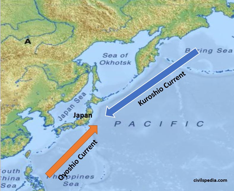
a. Oyashio current
It originates from the Bering
Strait and flows towards south carrying cold water.
It meets with Kuroshio warm
current
b. California Current
Californian current is flowing
towards south along the west coast of U.S.A between 48 N and 23 N
latitudes.
Has desiccating effect which
leads to formation of Mohave and Sonoran desert.
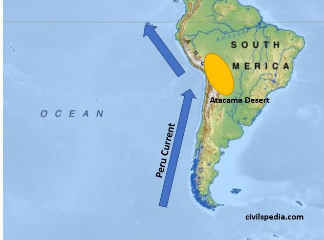
c. Peru Current
Peru Current is the best
studied ocean current of the Pacific Ocean.
Alexander Von Humboldt in 1802
noted the details of the Peru Current. Hence, it is also known as Humboldt
Current.
It flows north along the west
coast of South America carrying cold water
d. Alaska Current
Cold current originating near Alaska and flowing south to meet North Pacific Current
e. West Wind Drift
It is an easterly moving drift
in the Pacific Ocean extending from Tasmania to the South American coast.
It is a cold current.
The speed of the drift is
greater under the influence of Roaring Forties.
Warm Currents of Pacific Ocean
a. North Equatorial Current
North equatorial current
originates from Revilla Gigedo island west of Mexico due to trade winds
and flows towards the Philippines Island covering a distance of about
12,000 km
It gets divided into two and
the northern branch joins the Kuroshio Current and the southern branch
abruptly turns and forms the Pacific counter current.
b. South Equatorial Current
South equatorial current is
originated due the action of the trade winds from east to west
It is stronger than the North
equatorial current.
It is further divided into
many branches due to the presence of many islands and uneven surface
topography.
c. Kuroshio Current
Warm ocean current flowing in
north easterly direction up to 30 N latitude
It meets Oyashio cold current
off the Kuril Islands.
d. East Australian Current
Warm current flowing southward along the east coast of Australia
Side Note : Japan is good Fishing Ground
Warm Kuroshio Current & cold Oyashio Current meets near Southern Japan. Hence, it becomes rich fishing ground.
Along with that Japan has very shallow continental Shelf leading to more photic zone and more marine organisms.
Indented coastline of Japan leads to formation of natural harbors .
Furthermore, Japan is a hilly region with less developed agriculture . Hence, there is main role of fishes in Japanese Diet.
Side Note : Peru Current and Atacama Desert
Peru / Humboldt current is cold current. Hence, it provides desiccating effect to the South American coast leading to formation of Atacama Dessert . Atacama desert is one of the driest places on Earth.
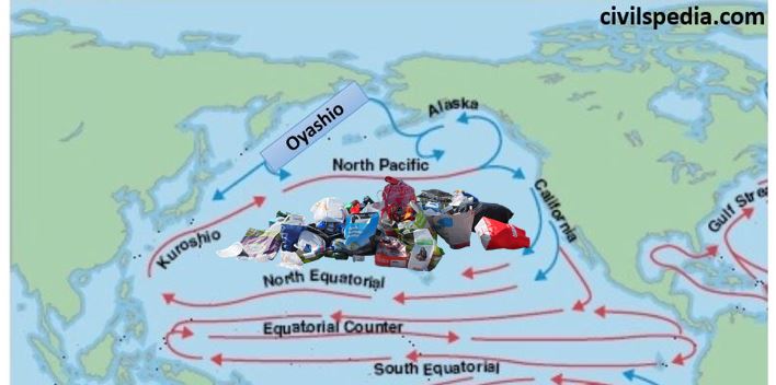
Current Topic : Pacific Garbage Patch
Pacific Ocean Garbage Patch is an enormous collection of marine debris (mainly plastic) that is collected and deposited by ocean currents in the middle of the North Pacific Ocean.
Reasons of
formation
Geographical
: Circular motion of the ocean currents draws debris into the center which is calm &
stable, where it becomes trapped.
Almost 80% of the debris in
the Great Pacific Garbage Patch comes from land-based activities in North
America and Asia&
the remaining 20% from boaters, offshore oil rigs, and large cargo ships.
The amount of debris in the patch accumulates since most of it is
non-biodegradable, mainly microplastics.
Impact
Destruction of marine life due
to ingestion of toxic and harmful
substances .
These toxic substances also
enters the food chain resulting in biomagnification
Presence of the garbage blocks the sunlight from reaching the planktons
and algae, thereby reducing productivity of marine ecosystem.
It affects the free flow of traffic through oceans.
Impacts the
tourism and
economic livelihood of small Pacific Ocean island countries
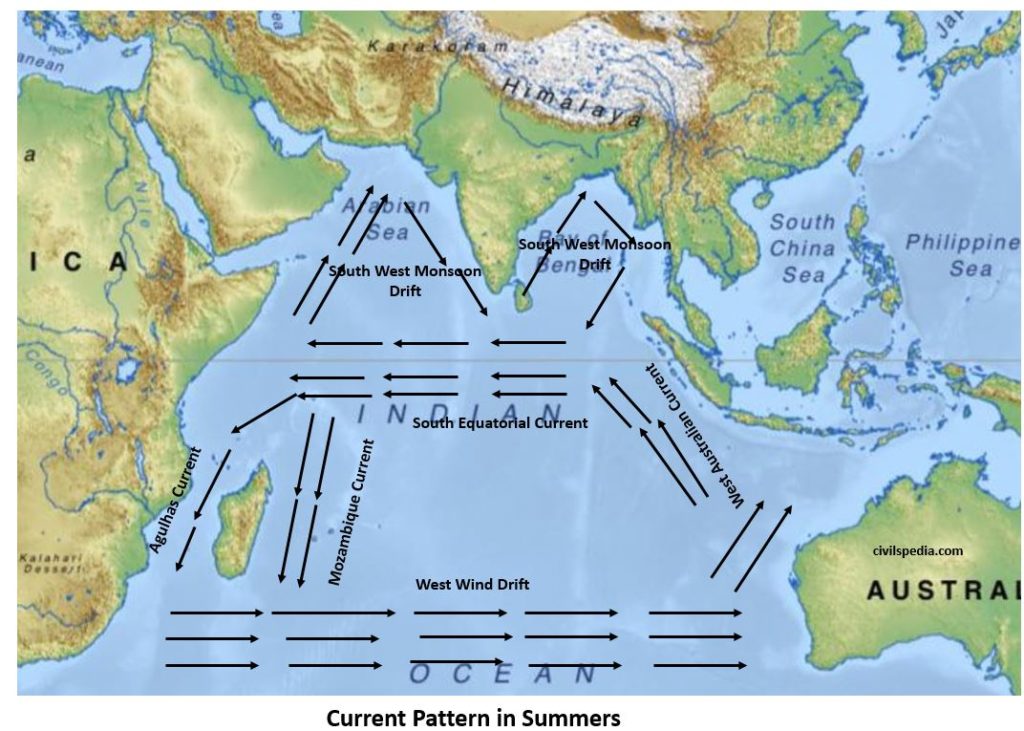
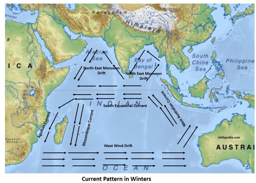
2.3 Currents in Indian Ocean
Current
system in Indian Ocean is unique & different from other current systems .
Why it is different than other currents?
In northern hemisphere, it is confined to tropical zone only & that too is divided by
Indian peninsula to form Arabian sea & Bay of Bengal.
Complete reversal in direction of winds as monsoon winds also impacts
the movement of current.
(wind is important factor – direction in which winds flow determine
direction of currents ).
Side Note : Navigation in Indian Ocean.
In Summer , Wind & current flows toward India .
Hence, sea vessel can move from Arabia to India .
In Winter, Wind & current flows toward Arabia .
Hence, sea vessel can move from India to Arabia .
Important for sea trade & cultural interaction since Ancient times.
Significance of Ocean Currents
Ocean Currents play an
important role in earth’s climate by distributing the energy within the
ocean. Along with that, they impact the local climate as
Warm ocean current increases
the temperature of an area
Cold ocean current decreases
the temperature of an area.
Currents also effect the
amount of rainfall.
Warm water currents increase
the rainfall because they bring winds along with them, laden with water
vapours. North America, Ireland,
Britain and south India receive rainfall because of this process.
On the other hand Atacama
desert remains dry because cold water currents don’t play any role in
occurrence of rainfall. Due to
this various deserts are situated on the western coast of Australia,
South America and Africa.
Currents helps in free
navigation navigation as Norweigian Current keeps ports of Scandinavia
navigable throughout the year and Kuroshio Current keeps ports of Japan
navigable during winter.
Conjugation of warm and cold
water currents helps in increasing the development rate of ‘Plankton’,
which is a diet of fish. This
conjugation takes place of eastern coast near New Found land in North
America, Bahia Blanca in South America, Japan coast in Asia etc. But on
the other hand conjugation of
currents forms dense fog which creates problem for marine navigation.
Sometimes ships are not able to move because of this fog. This whole situation effects the
economic activities of respective areas.
3. Vertical Motion of Ocean Water : Upwelling & Downwelling
Vertical circulation of ocean water takes place due to difference in salinity and temperature between the surface and the water deep below.
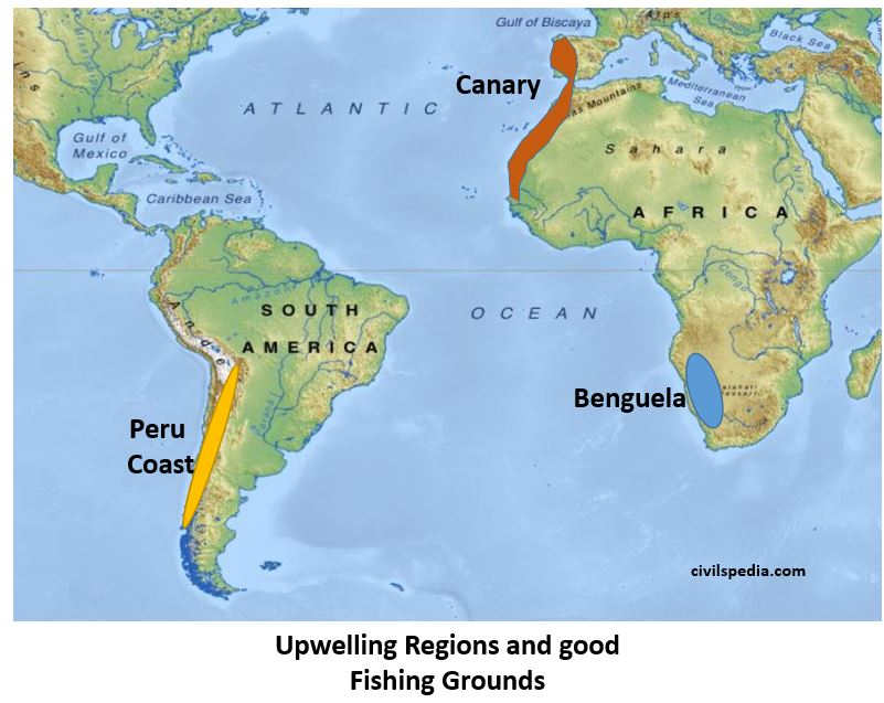
Upwelling
Upwelling is an oceanographic phenomenon that involves movement of dense, cooler, and usually nutrient-rich water towards the ocean surface, replacing the warmer, usually nutrient-depleted surface water.
UPWELLING & FISHING
Cool & nutrient rich water
come at surface.
Phytoplankton reproduce
rapidly in this condition => Consequently, fishes increase as well.
All Upwelling
Regions in World are good fishing ground. Eg : Canaries,
Benguela and Peru Coast
Downwelling
Down welling is the
process of accumulation and sinking of cold high saline water beneath
warmer or fresher water.
Not good for fishing .
4. Vertical Movement : Tides
What are tides
Rhythmic rise & fall in
level of ocean water.
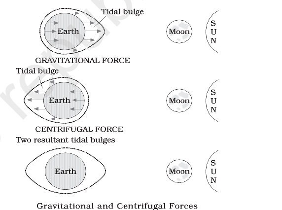
Causes of tide formations (Prelims-2015) .
Moon’s gravitational pull is the most important
factor.
Sun’s gravitational pull ( although not as
prominent factor as Moon’ pull but still a major factor)
Centrifugal force due to earth’s rotation ( mainly responsible for
causing bulges).
On the
side of Earth facing the moon , a tidal bulge occurs while on the opposite side
although the gravitational attraction of the moon is less as it is farther
away, the centrifugal force causes tidal bulge on the other side
Stages of Tides
Stage I
Sea
level rises over several hours & cover the intertidal zone – flood
tide.
Stage II
Water
rises to highest level – high tide.
Stage III
Sea
level falls over several hours revealing intertidal zone – ebb tide.
Stage IV
Water
level stops falling – low tide.
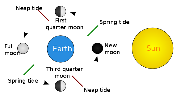
Syzygy
Alignment of three or more
celestial bodies of same gravitational system in a line.
Effects tides in form of
variation between high tides & low tides.
a. Spring tide
Sun , moon & earth are in
line.
Occur on full moon or new moon (no moon day)
When there is greatest
variation between high tide & low tide .
High tide is higher than
normal high tide & low tide is lower than normal low tide.
b. Neap tide
Sun , Earth & Moon are at
right angle.
Occur when moon is at quarter
phase.
High tide lower than normal
high tide & low tide higher than normal low tides.
Daily frequency of Tides
Earth rotates & moon revolve in same direction, hence in relative term wrt to moon earth take 24 hrs & 52 minutes to complete one rotation.
2 high tides & two low tides in a day (24.52 hours to be exact)=Semidiurnal
Most enclosed water bodies & bodies away from open ocean experience only one high & one low tide .
Tidal Current
Movement of ocean water as a
result of tidal action is known as a tidal current.
In places of narrow coastal
inlet these tidal currents flow rapidly through the mouth with greater
height and velocity. For example in the Bay of Fundy, between Nova Scotia
and New Brunswick of Canada, the difference between high and low tides is
as high as 14m. Ports which utilize the tidal current for entry and exit
of ships from the harbour are known as tidal ports.
Importance of Tides
Creates inter-tidal regions which have special ecology of
their own. Eg : Sunderbans
Since tides are caused by the
earth-moon-sun positions which are known accurately, the tides can be
predicted well in advance. This helps the navigators and fishermen plan
their activities. Tidal flows are of great importance in navigation.
Tidal heights are very important, especially near rivers and
within estuaries having shallow ‘bars’ at the entrance, which helps ships and boats in entering into the
harbour.
Tides are also helpful in desilting the sediments and in removing
polluted water
from river estuaries.
Tides are used to generate electrical power (in Canada, France, Russia,
and China). A 3 MW tidal power
project at Durgaduani in Sunderbans of West Bengal is under way.
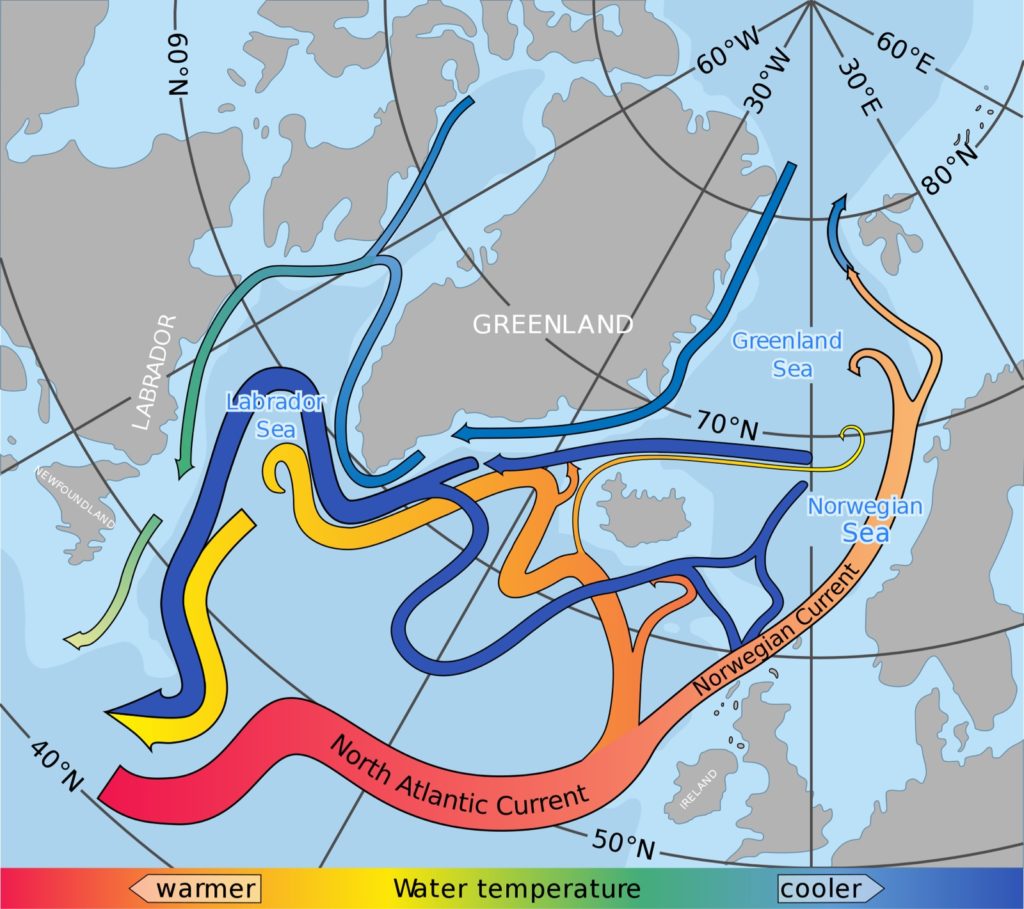
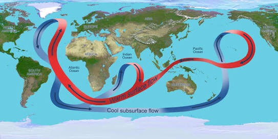
5. Thermo-Haline Circulations
Circulation because of the
temperature & salinity of the ocean.
Main driving force is freezing
of water at Atlantic and salinity .
Sequence
First of all water goes to
Polar Region ( Atlantic) . It interacts with the land which is very cold
and freeze . When water freezes, it will increase the salinity of
sub-surface water (because salt separates from water before freezing) .
Subsurface water will become
dense and goes further down. Consequently, it starts to flow as
sub-surface cold current. It will come to South Atlantic ocean and from
there to Indian and Pacific Ocean till the Bering Strait where it upwells
.
Then surface water starts to
flow back .
Note : This process is very slow and time frame between downwelling
and upwelling can take upto thousand years .
Impact of Climate Warming on this
Due to climate change , more
fresh water is being added in Atlantic . This will reduce the salinity
which is the driving force behind whole process.
Hence, climate change and
global warming will negatively impact this circulation
This article deals with ‘Oceanography: Relief features of Ocean.’ This is part of our series on ‘Geography’ which is important pillar of GS-1 syllabus . For more articles , you canclick here
Introduction
Hydrosphere
covers 70% part of Earth surface and is one of most important Spheres for
various living organisms and vegetation. Of the hydrosphere, 97.2% of water on
Earth is present in Oceans.
The oceans, unlike the continents, merge so naturally into one another that it is hard to demarcate them. The geographers have divided the oceanic part of the earth into five oceans, namely the Pacific, the Atlantic, the Indian, Southern ocean and the Arctic. The various seas, bays, gulfs and other inlets are parts of these four large oceans.
Oceanic Crust
Oceanic Crust is the most
fundamental crust.
It is Basaltic in nature .
Oceanic crust is more denser & darker than Continental Crust.
Age of continental shelfs is 1 billion year, oceanic crust
is younger & nowhere aged more than
200 million years .
Deepest point in ocean is
Mariana Trench (in Pacific ocean near Northern Mariana Islands with depth
10,971 m )
Oceanic Crust
is created at Mid Oceanic Ridge
& destroyed at Trenches.
Ocean floor
is not flat & more diverse than continents & quite different from
continental ones.
Oceans
consist of
71% of earth’s crust.
Division of Ocean
To study ocean bottom properly it should be divided into two divisions
Ocean Continent Margin.
Deep Ocean Plains.
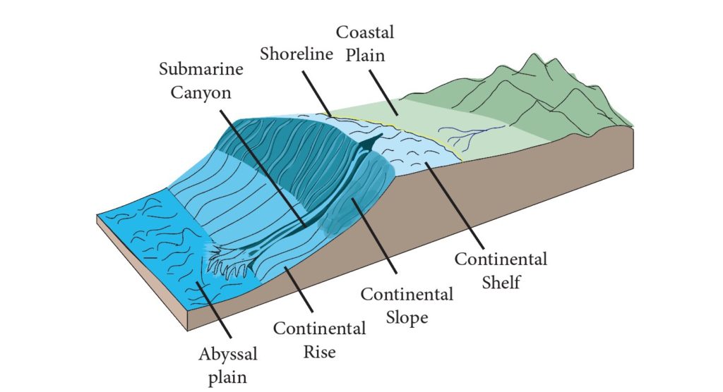
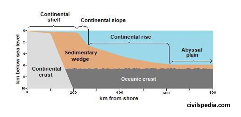
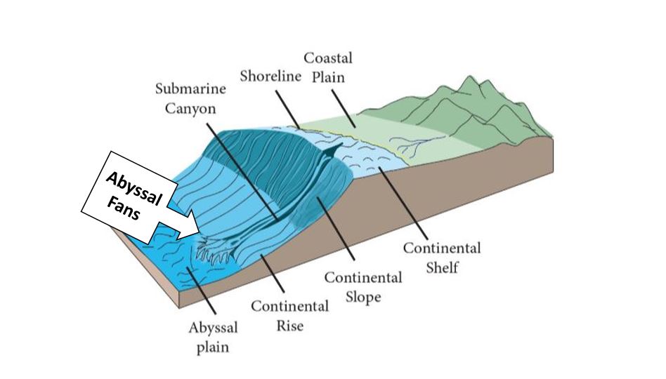
1 . Ocean Continent Margin
Meeting point of ocean & continental crust . It
can be divided into three parts.
Coast / Coastal Plain
Continental Shelf
Continental Slope
Continental Rise
1 . 1 Coast
Coast can
be of two types
Submergent Coast : Estuarine , Ria , Fiord and Dalmatian
Emergent Coast
1 . 1 . 1 Submergent Coast
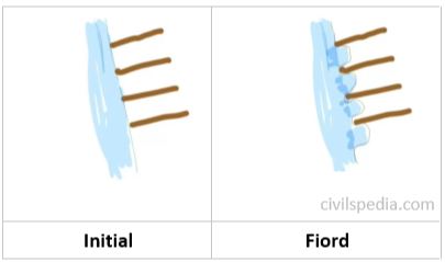
a. Fiord
Initially mountains are perpendicular to the coast . Glaciers come down to the coast forming u-shaped valley submerging the area. Hence, coastline which was initially straight becomes indented
Eg : Norwegian Coast
b. Ria
If valleys were submerged by rivers (instead of Glaciers) , it is called Ria
Eg : South Hampton, Wales,
British Isles etc
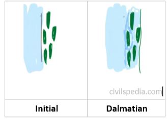
c. Dalmatian
If mountains are parallel to the coast (instead of perpendicular)
If ships are entering this
coast, they face barriers
Eg : Adriatic Coast (Italy)
d. Estuary
If normal low land region (not mountainous) is
submerged at the
mouth of river .
Eg : Thames, Buenos Aires
1 . 1.2 Emergent Coast
a. Lowland Emergence
It usually results in lagoon,
salt marshes, long beaches
Eg : Eastern Coast of India
b. Emergent Upland Coast
No natural harbors are found here
Eg : Scotland
1 . 2 Continental Shelf
Continental shelf is the seaward extension of land that lies under the sea water. It occupies 7% of the sea floor.
It is quite shallow (approx 200m ).
Region is called PHOTIC REGION ie receives large amount of sunlight . Marine organisms are found here (all floating planktons , benthos(crabs) & nektons(fishes)).
It has gentle slope with an average gradient of 1° or even less. The shelf typically ends at a very steep slope, called the shelf break.
Width varies – The shelves are almost absent or very narrow along some of the margins like the coasts of Chile, the west coast of Sumatra, etc. On the contrary, the Siberian shelf in the Arctic Ocean, the largest in the world, stretches to 1,500 km in width . (average width is 80 km)
The depth of the shelves also varies. It may be as shallow as 30 m in some areas while in some areas it is as deep as 600 m (Less depth means it will have more photic zone).
Made up of Granite rock ( because it is part of continental crust).
The continental shelves are covered with variable thicknesses of terrigenous sediments brought down by rivers, glaciers, wind, from the land and distributed by waves and currents. Massive sedimentary deposits received over a long time by the continental shelves, become the source of fossil fuels.
Continental shelves are well known for oil, natural gas, mineral deposits, sulphur, marine fishery etc. Large number of resources are found in continental Shelf.
a. Petroleum
90% of petroleum reserves of
world are found on continental shelves.
Because petroleum is formed
from submergence of marine
living organisms which get converted to petroleum under high temperature
& pressure (marine organisms like fish etc are maximum on Continental
Shelf because of Photic Zone)
Examples : Bombay High, Gulf
of Cambay, Persian Gulf, North Sea, Barents Sea(Russia) , Gulf of Mexico,
Norwegian Sea .
b. Sulphur
Rarely found on land .
Available in sea because
of marine
volcanism .
Gulf of Mexico is rich source of Sulphur.
c. Placer Deposit
Wave action erode beach rocks but there are some materials in rock which don’t disintegrate easily . Disintegrated material of lower weight is moved very swiftly by waves but heavy non-disintegrated material keeps on concentrating on shelf . These are called Placer Deposit.
Example are as follows
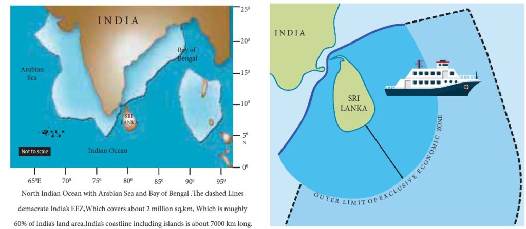
Monazite Sand found on Kerala Coast which is source of Thorium . It is important for Indian Nuclear Program
Gold in Alaska .
Zircon on coast of Brazil & Australia.
Diamond on South African Coast .
d. Calcium
Least soluble in ocean water
& can be easily extracted .
Peruvian
coast is rich in Calcium &
Phosphate .
e. Fishes
Due to photic zone and
availability of planktons , fishes are also found in the wasters of
Continental Shelf.
World famous fishing grounds
like Grand Bank are situated here
f. Pearls
Pearls of ornamental value are also found here.
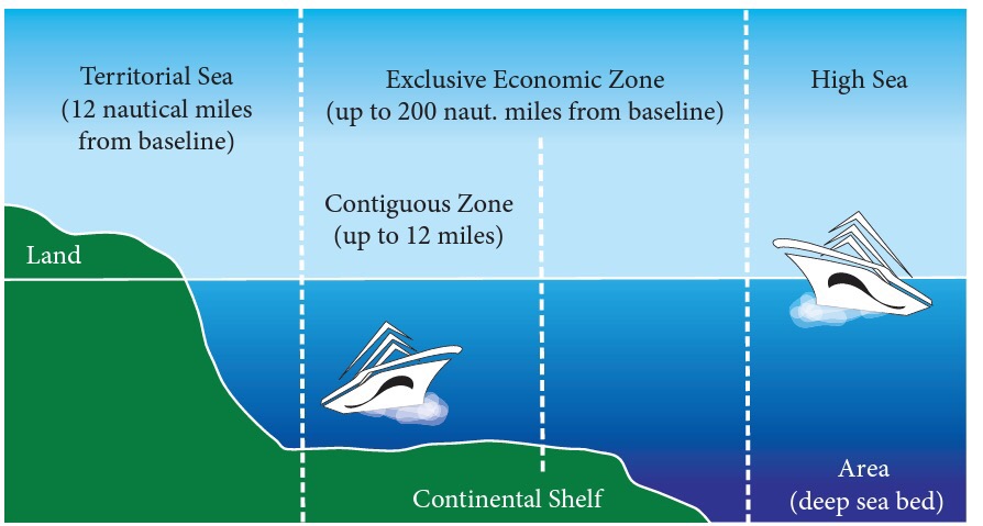
Side Topic : Sea Boundaries (under UNCLOS)
a. Internal waters
All the water that is inside the coastline is called Internal Waters
State has complete sovereignty
over this and it is equivalent to
territory of country
b. Territorial Sea
Upto 12 Nautical Miles (1 NM = 1.85 Km)
(provided there is no other country on the other side. If any other
country is present, it becomes midway)
Here too almost all of the
laws of the land apply. It is almost as good as territory
Vessel of any other nation
need permission to enter into territorial waters of other country &
submarine has to come on surface & declare its identity while
navigation .
c. Contiguous Zone
Upto 24 Nautical Miles .
Some dilution of political
laws
Navy & Coast Guard cant
guard this but if criminals like smugglers after doing some crime try to run then that
country can follow them till this point .
d. Exclusive Economic Zone (EEZ)
Upto 200 Nautical Miles.
All the economic
laws of country apply but political
laws don’t apply here
Country can explore both biotic and abiotic
resources of the water and ocean floor .
Other countries have right to
peaceful passage .
Exceptional Case
If Continental shelf is beyond 200 Nautical Miles , country can claim EEZ upto that point with maximum limit of 350 NM
Within this extended zone, state has exclusive right of exploiting and exploring non-living resources of the sea bed as well as sedentry species on the sea bed. Fishing rights arent inclusive in 200 to 350 Nautical Miles.
d. International waters / High Sea
Beyond EEZ
Here resources belong to
everyone. No nation has sovereign rights over this area.
Side Topic : Nautical Mile
It is the distance
per one
minute of latitude (1/60th of 1 degree)
1 Nautical Mile = 1.85 Km
(1.85*60=111 Km = Distance
covered per degree latitude . )
At equator, 1 degree of longitude is also 111 km . But this distance
keep on reducing while going North and South and is 0 at poles . But distance
between latitudes is always same (because they are parallel) and is 111 km
approx at every point
1 . 3 Continental Slope
The zone of steep slope extending from the continental shelf to the deep sea plain or abyssal plain is called continental slope.
It has very steep slope .The slope angle varies from 5° to 60°.
No deposition is possible because of steep slope . Hence, no resources are found in this zone.
But some unique landforms are created specially when there is mouth of very large river at continental shelf like Indus, Ganga, Mississippi, Yukon & Congo. Example of such landform are
SUBMARINE CANYONS in which flow of water would be so great that it will vertically erode both continental shelf & slope . In Indian Ocean, submarine canyons are found at mouths of river Ganga and Indus.
Underwater Waterfalls – Highest waterfall on earth is under the Denmark strait.
1 . 4 Continental Rise
Transition between Continental
Slope & Sea Floor.
There would
be no continental rise in case there is TRENCH after Continental
slope .
2 . Deep Ocean Plains
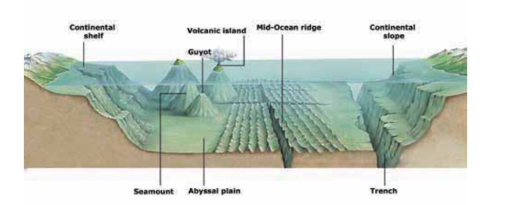
Major portion of Ocean Crust consist of Deep Ocean Plains which have various relief features like Mid Ocean Ridge, Islands, Guyots etc. These are as follows :-
2 . 1 Abyssal/ Deep Sea Plains
Occupies 40% of ocean floor.
Consists older parts of oceanic crust that are smoothened
due to sediment deposition.
Among flattest, smoothest
& least explored regions of earth.
Average depth varies from 3000
to 6000 metres .
It has deposits from
continents( terrigenous), marine life(biogenous) & salts and
minerals(inorganic).
Abyssal plains of Southern
Indian Ocean and Eastern Pacific Ocean are rich sources of Poly Metallic
Nodules.
Side Topic : Poly-Metallic Nodules (PMN)
Polymetallic Nodules (AKA Manganese Nodules) .
Multiple metals are concentrated around core .
Found at depth of around 4,000 to 6,000 m on the floor
Were first found around Kara Sea & Arctic sea but later nodules were found in all oceans .
But are economically viable to extract only in Central Indian Ocean & Eastern Pacific Ocean.
Composition : Manganese (Highest) and apart from this contain Iron , Silicon, Al, Nickel & Cobalt & some rare metals.
Important for India as India doesn’t have good source of Nickel & Cobalt .
Countries are in race to explore & extract PMN.
2. 2 Islands
An island is a landmass surrounded by water on all sides.
They are of four types
a. Continental Island
Once part of large continent.
Examples : Sri Lanka,
Madagascar, Vancouver, Baffin islands.
Note : Madagascar Island formed after separation from Indo-
Australian Plate
Generally bigger in size than
all other categories of Islands.
Rock composition and all of
continental island is same as plate from which it is separated .
b. Volcanic Island
Ocean – Ocean plate collision
or Hotspot activity.
Marine organisms, the coral
polyps colonize the tropical warm water and form islands known as coral
islands.
Examples include Lakshadweep,
Maldives, Mauritius, Bahama & Bermuda
d. Sandbar Island
Formed by accumulation of sand
near coast => Sand which is eroded from main land is again settled near
coast & if continental shelf is shallow nearby then sandbar island is
formed .
Example : Long Island (New
York)
Side Topic : Archipelago
Cluster of islands .
(GK) Largest archipelago.
By area
Indonesia
By number of islands
Finland
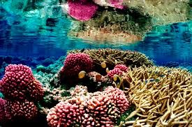
2.3 Coral Reefs
Corals are indicative of health of Marine Ecosystem ie if coral reef exists at any place in healthy way , entire ecosystem is healthy.
Wherever there is coral reef , you will find great biodiversity at that point.
Most diverse ecosystem of world => 10% area but 25% marine species . They can be said to be Rain Forests of the Ocean.
What are corals?
Corals are tiny fleshy Sea Anemones Polyps.
They extract Calcium from sea
water for their skeletons to protect their body.When one generation die
other generation comes on it.
Corals live in symbiotic relationship with microscopic algae- Zoo-xanthalae which have photosynthesis
capabilities.
Zoo-xanthalae provide food to
corals and corals provide protection to zooxanthalae.
Conditions conducive for corals
Water temperature in
the range of
22-29 degrees
Celsius. Thus,
areal distribution of
corals is limited to tropical
and sub-tropical zones.
They will
not flourish in
areas of cold
currents but thrive
in warm current
regions. Therefore, they
are generally absent
on western coasts
of continents.
Depth
of water should
not exceed 180 feet
as the sunlight
is too faint
for photosynthesis which
is essential for survival
of microscopic Zoo-xanthalae
on which coral
polyps depend. However,
there should be plenty of
water as polyps cannot survive for too long
out of water.
Water should be
salty and
free of sediments.
Corals are best
developed on seaward
side of reef,
where constantly moving waves, tides and currents maintain an abundant supply
of clear, oxygenated water
Spatial Distribution of corals in the world
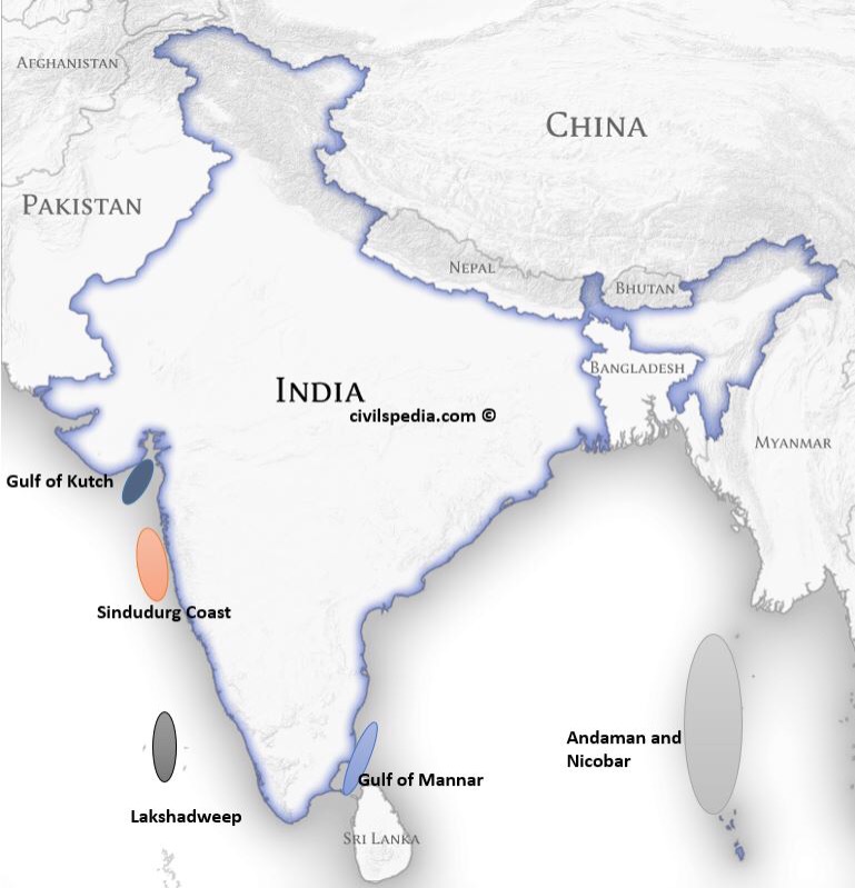
Spatial distribution of Corals in India
In India
they are found in
Gulf of Mannar.
Andaman &Nicobar
Lakshadweep
Gulf of Kutch
Sindudurg coast ( near Malvan
Coast) in Maharashtra ( only here
in India, bleaching hasn’t happened yet)
While
the Lakshadweep reefs are atolls, the others are all fringing reefs.
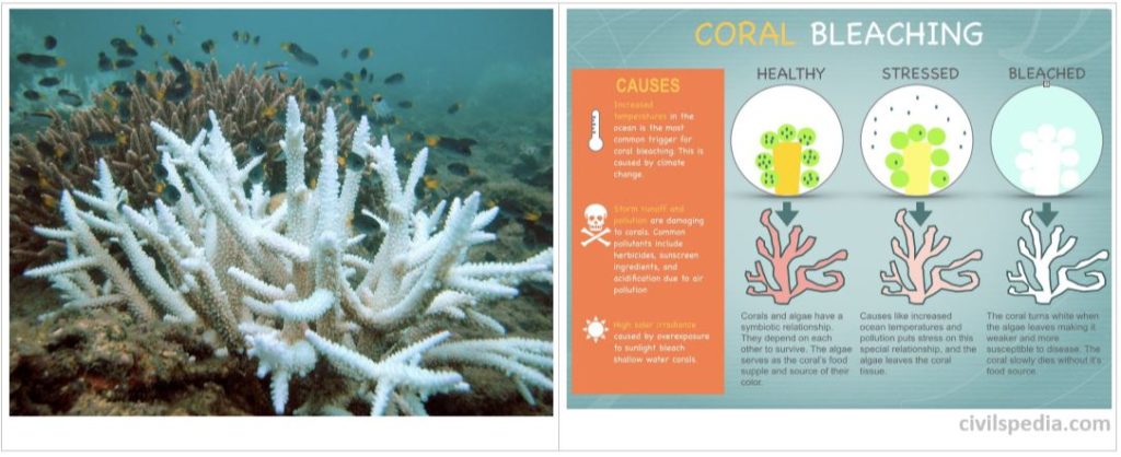
Coral Bleaching
When corals are in stress they expel Zoo-xanthalae.
Zoo-xanthalae give the colourful appearance to corals . In their absence, corals seems white (their original colour) .
Ultimately without food corals will die out too.
Reasons of coral Bleaching
Global Warming : increase in sea surface temperature .
Ozone Depletion : increase in solar irradiation.
Ocean Acidification : because of increase in Carbon Dioxide in atmosphere . This Carbon Dioxide dissolves in ocean water & water becomes acidic . Corals can’t live in acidic water
Algal Bloom : excessive use of fertilisers go to ocean through rivers resulting in Algal Bloom . Sunlight cant go below & corals die.
Increase in sedimentation from rivers.
Marine pollution like oil spills . No sunlight & oxygen reach below.
Diseases.
Coastal construction and shoreline development: Results in heavy sedimentation
Coral mining: Live coral is removed from reefs for use as bricks etc.
Consequences of Coral Bleaching
It will impact marine
ecosystem, as coral reefs are some of the most bio diverse and productive ecosystems.
Reefs act as natural barriers to shorelines, protecting them from the
effects of moving water. As coral reefs die, coastlines become more susceptible to damage and
flooding from storms, hurricanes, and cyclones.
Ocean will not be able to absorb as much
Carbon Dioxide
because Zoo-xanthalae
absorb Carbon Dioxide for photosynthesis leading to increased Global Warming.
Measures need to be taken
Political measures: The global agreements combating climate change must
keep the needs of coral islands as top priority.
Switching to sustainable livelihood measures: It is high time to recognize
the carrying capacity of each coral island ecosystem and limit population
growth, tourist foot fall etc. at these islands.
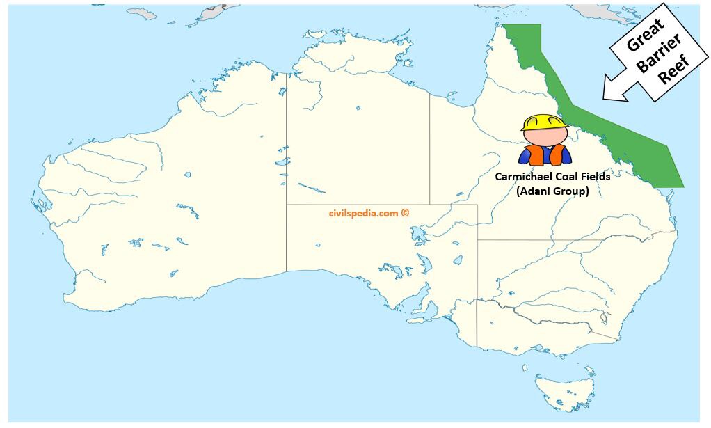
Sustainable development : Avoid major projects in threatened areas. Eg :
Carmichael Coal Mine in Australia that threatens Great Barrier
Reef should be avoided.
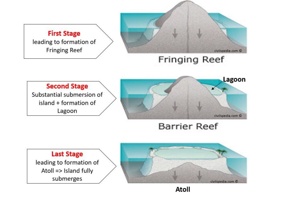
Formation of Coral Reef
Coral Reef
can be developed both at margins of continents or around islands .
3 stages of coral formation are as follows
Stage 1 : Fringing
Coral reef starts to develop along margin
of an island
& subduction of island just starts
First stage of Fringing Reef
Stage 2 : Barrier Reef
Corals keep on accumulating
and keep on rising upwards. As a
result, large part of island is submerged in sea/ocean.
Lagoon formation occurs
Stage 3 : Atoll
Last Stage
Island is submerged & only ring remains visible .
Note : In India, while the Lakshadweep reefs are atolls, the others are all fringing reefs.
Side Topic : Great Barrier Reef , Australia
Adani’s are investing in Coal Fields in Australia (Carmichael Coal Fields) . Project will create jobs for
Australians and coal will be imported to India
But due to large
Carbon-dioxide emissions in the area
, Great Barrier Reef will be impacted heavily.
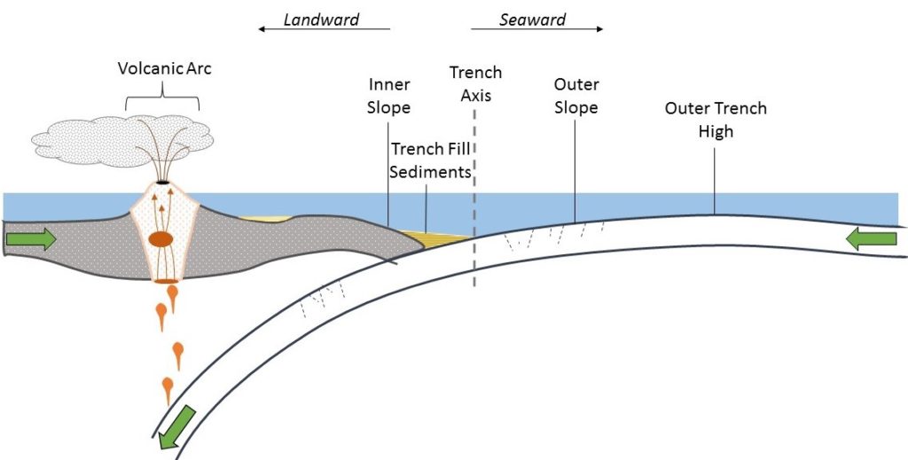
2.4 Oceanic Trench/ Oceanic Deep
The long, narrow, steep-sided
depressions formed along the
convergent boundary where one plate subducts below the other is called Ocean trenches.
The Challenger
Deep in the Mariana Trench, (10,994 m) in the Pacific Ocean
is the deepest part of the earth.
Most trenches are in Pacific ocean & they are most active geological feature. Great earthquakes
leading to Tsunamis occur here.
As many as 57 deeps have been
explored so far; of which 32 are in the Pacific Ocean; 19 in the Atlantic
Ocean and 6 in the Indian Ocean.
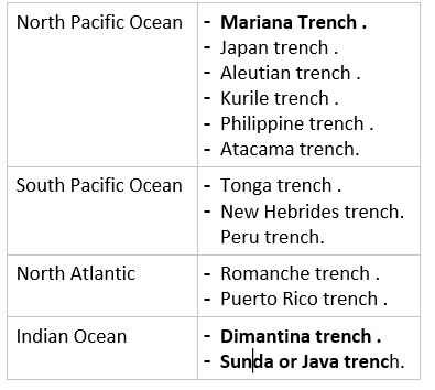
Main Trenches of the world
2.5 Seamounts / Guyots
Flat topped volcanic hills submerged under the sea water are called guyots.
Seamounts are conical, volcanic hills submerged
under ocean water
Seamounts , guyots and the water column above them serve as
important habitats, feeding grounds and sites of reproduction for many
open-ocean and deep-sea species.
2.6 Abyssal Fans
Also known as Deep Sea Fans or Underwater Deltas or Submarine Fans .
Delta like structure formed at deep sea surfaces . Major reservoirs of biodiversity.
2.7 Mid Oceanic Ridge
Mid-ocean ridges are submarine mountains.
Mid oceanic ridges are located on the divergent plate boundaries where magma flows through the fissure to form new oceanic crust. They form the longest mountain range in the world extending for more than 56,000 km long.
This article deals with ‘Office of Profit Issue.’ This is part of our series on ‘Governance’ which is important pillar of GS-2 syllabus . For more articles , you canclick here
What is Office of Profit ?
According to Articles 102(1) a and 191 (1) ,
Person shall be disqualified for being a MP or MLA if he holds any “office of profit” under the government of India, a state or a union territory other than an office protected by law.
But term Office of Profit is neither defined in the constitution nor under Representation of People’s Act.
Legislatures kept on expanding the list of exemptions from disqualification
Supreme Court in Pradyut Bordoloi vs Swapan Roy (2001), outlined the following
questions for the test for office of Profit:
Whether the government makes
the appointment
Whether the government has
the right to remove or dismiss the holder
Whether the government pays
the remuneration (salary or honorarium)
What are the functions of the
holder and does he perform them for the government
Later : Not all but any one of above condition is sufficient to
declare particular office as office of profit
Earlier Cases
2004
Jaya
Bacchan v. Union of India : In
2004, Jaya Bachan, Rajya Sabha MP from the Samajwadi Party, was appointed
chairperson of the UP Film Development Council (UPFDC) but she wasn’t
receiving any salary . The apex court held that it was an Office of Profit,
and disqualified her from being a member of the Upper House arguing that “an office which is capable of yielding a profit or pecuniary gain.” thus it is not the actual
‘receipt’ of profit but the ‘potential’ for profit that is the deciding
factor in an ‘office of profit’ case.
2006
In
2006, BJP MPs sought the disqualification
of Congress president Sonia Gandhi from the membership of the Lower House for holding an Office
of Profit. Sonia was then chairperson of the National Advisory
Council (NAC). She resigned her Lok Sabha seat,
recontested the election, and came back.
Legislative History
Concept originated in the House of Commons in England. King in his efforts to
undermine the House of Commons, used to offer positions of executive
nature with pecuniary benefits to its members and buy their loyalty. This
practice kept the members out of the House most of the time . Hence, House
of Commons passed a law prohibiting its members from accepting any office
from the Crown
In Modern times,
Constitutional theory envisages that the elected legislature exercises
oversight functions over government. Therefore, if the legislators are beholden to the
executive, the legislature can no longer retain its independence and loses
the ability to control the Council of Ministers
=>
Hence, main issue is not of Pecuniary Benefits but weakening of Principle of
Separation of Power.
Arguments against MPs/ MLAs holding Office of Profit
Against Separation of Powers: legislator cannot exercise control over Executive of which he/she becomes a part.
Circumventing Constitutional Provisions : Office of Parliamentary Secretaries or other offices are used by state governments to circumvent the constitutional ceiling of 15 % (10% in case of Delhi) on the number of ministers they can appoint.
Threat to Public Interest and National Security : Unlike ministers, the Parliamentary Secretaries are not administered under the Oath of Secrecy (Art 239 AA(4)), yet may be privy to such information which may threaten public interest or threaten national security.
Recommended by Various Committees : Various committees have spoken against it including 2nd ARC & V K Krishna Menon Committee
Used for Political Reasons without any benefit in governance : Chairmanships of Corporations, Parliamentary Secretary-ships of various ministries, and other offices of profit are often sops to legislators to satisfy their aspirations for rank, status and privilege and a way of buying peace for the government.
Side Topic : MPLADS
In 1993, the Central
government started MPLADS, through which legislators can earmark a certain amount of public
funds for projects in their constituency. The concept has been adopted by
many states as MLALADS.
Argument was that elected MPs
and MLAs know the needs of their electorate well and can be effective in
allocation of resources.
Issue
:Role of Legislators is to allocate the entire Central and State budgets, and
to monitor the spending. They are expected to use their knowledge of
ground-level issues in this allocation, and see that the funds are spent
properly. By providing each of them a specific amount to spend on projects,
their oversight role is weakened.
Suggestion of 2nd ARC : Schemes such as MPLADS and MLALADS should be abolished.
Current Issue : Parliamentary Secretary Cases
2016
– Article 239AA of the Constitution limits the number of Ministers in Delhi Government to 10% of the strength of Delhi Legislative Assembly (which is seven persons).
– They appointed 21 more MLAs as parliamentary secretaries — which will make 40 per cent of the membership have some type of an executive role.
– Delhi Members of Legislative Assembly (Removal of Disqualification) Act, 1997 was amended with retrospective effect to exempt the post of parliamentary secretary from the definition of the “office of profit”. However, Lt. Governor didn’t give assent to the amendment bill
2017
Punjab and Haryana high court quashed the appointments of four Haryana Chief Parliamentary Secretaries (CPSs).
2018
MLA’s in Delhi were disqualified by President for
holding Office of profit.
Who are Parliamentary Secretary ?
Parliamentary Secretary is a member of the parliament in the Westminster
system who assists a more
senior minister with his or her
duties. Originally, the post was used as a
training ground for future ministers.
Post has been created in
several states now and then like Punjab, Haryana, Delhi and Rajasthan etc
and by Act of State Legislature, they are declared to be out of
disqualification
Main issues with this post ?
All the issues discussed in Office of Profit debate like impinging Separation of Power, Conflict of Interest etc are relevant here as well.
Points given in Support
Constitution allows a legislature to pass a law to grant
exemption to any office of profit holder. In past, states and Parliament
have done this as well. The Supreme
Court in UC Raman case has upheld this.
Structured preparation for Olympics – Target Olympic Podium Scheme (TOPS) of Union Ministry of Youth
Affairs and Sports to identify and support potential medal prospects for
2020 and 2024 Olympic Games.
Promoting grassroots level talent – through Khelo India Scheme which include Khelo India School Games to recognise
young talent as well as creating infrastructure for sports in Urban and
Rural Areas
August 2018 : National Sports University Bill 2018 – National Sports University
will be opened in Manipur to enhance country’s standing
in sports
Use of Narcotics : Large number of Indian athletes fail in Doping
tests which hits prestige of country. Most of cases are such that athlete
is unaware of the fact that supplements he is taking are banned. Frequent
workshops should be organised in this respect
Apply Lodha Recommendations to other sports : Acceptance of Lodha committee recommendations has generated awareness & generated demand for reforms in other games as well. The recommendations of Lodha committee which can be applied to sports in general are:
Barring civil servants and ministers from becoming member of the sports federations and associations
Limits on the duration of the tenure and number of times a person can become a member of sports bodies
Former and existing Players should be associated with the bodies of their respective games
Auditing of accounts should be done by CAG nominee
Bringing sports bodies under RTI (Issue of BCCI under RTI is discussed in subsequent section).
Break the monopoly of cricket : Other games should be
promoted as well. For this , approach should be regional on basis of where
there are potential viewers . In end , we have to accept the fact that,
today promoters encourage those sports only which can generate revenue and
viewership . Eg : Promote
Football : North East , West
Bengal, Goa, Kerala
Hockey : Punjab , Orissa etc
Wrestling : Haryana, Punjab ,
UP
Swimming : Coastal States
China Model : Our program to get medals at Olympics should be long .
Like China, India should identify the potential junior players which can
be trained for atleast decade to make a world class player out of him .
This article deals with ‘Police Governance.’ This is part of our series on ‘Governance’ which is important pillar of GS-2 syllabus . For more articles , you canclick here
Introduction
Police in almost all states is
governed by Police Act , 1861 which was made
to secure & strengthen Raj. Now same is used by Government to strengthen its hold
There have been many number of
commissions, both at the State and Central level – State Police Commissions, National Police Commission,
Gore Committee, Ribeiro Committee, Padmanabhaiah Committee, Malimath
Committee, to name only a few
Why in news?
This topic remains in news always. Eg :-
June 2020
Rage over custodial death of father-son duo in Tamil
Nadu
Why do we need police reforms ?
Biggest problem is Political Interference .
Economic progress cannot be sustained if we are not able to generate a safe and secure environment.
Numbers: global average ratio of police-population is 270 to 1,00,000, where it is 120 in India.
Low standard of Criminal Investigation
Human right violation : Inspite the known fact that Police indulge in Human Rights violations like custodial deaths and fake encounters ,but convictions are few. Eg : Tuticorin custodial killing case of 2020 in which father-son duo was killed by police leading to huge furore in the country.
Lack of expertise in Collection and analysis of preventive intelligence
Outdated arms and equipments: as seen in 26/11 attacks.
Lack of proper training.
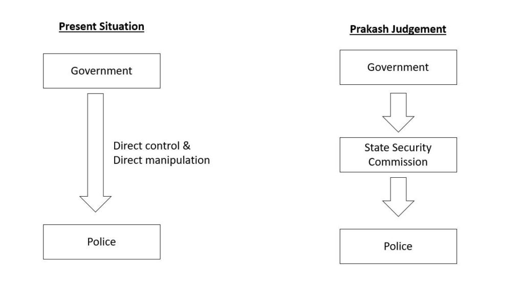
Prakash Singh judgement,2006
Based on recommendation of various committees , SC gave broad guidelines to be implemented to reform Police in India
Directive 1
Constitute a State Security
Commission (SSC) to:
Ensure that the state government does not exercise unwarranted influence or pressure on police
Lay down broad policy guideline and
Evaluate the performance of the state police
How State Security Commission
will help
Directive 2
Ensure that the DGP is appointed through merit based transparent process and secure a minimum tenure of two years.
Directive 3
Ensure that other police officers on operational duties (including SSP (incharge of District) & SHO ( in-charge of a police station)) are also provided a minimum tenure of two years.
Directive 4
Separate the investigation and law and order functions of the police
Directive 5
Set up a Police Establishment Board (PEB) to decide transfers, postings, promotions of police officers.
Directive 6
Set up a Police Complaints Authority (PCA) at state level to inquire into public complaints against police officers .
Directive 7
Set up a National Security Commission (NSC) at the union level to prepare a panel for selection and placement of Chiefs of the Central Police Organisations (CPO) with a minimum tenure of two years.
Are these directives implemented ?
Almost no state seems willing to implement police reforms in letter and spirit. 17 states have passed new Acts while 12 have issued executive orders. But concerted efforts have been made by all to circumvent the SC directions . Thomas Committee, appointed by the Supreme Court to monitor the implementation of its directions in various states, in its report in 2010 deplored that “practically no state has fully complied with those directives so far, in letter and spirit”.
Main lynchpin of the directive was formation of State Security Commission (SSC) with members from the government, judiciary and civil society. But 17 States which have made SSC , it’s composition is flawed . Most states have avoided having the opposition leader in commission and independent members have been kept away.
Most states have refused to give more than a one-year fixed tenure to DGP . Reasons for DGP’s removal tenure have been kept vague with grounds ranging from ‘public interest’ and ‘administrative exigencies’ to ‘any other reason’.
Except Kerala and Karnataka, no state has provided for complete separation of law and order and investigation duties.
Centre, too, has been dragging its feet on the issue. It has as not yet set up the National Security Commission.
Parkash Committee Report (June 2016)
Was formed in wake
of riots in Haryana during Jat agitation in which property worth
billions was damaged and more than 30 persons were killed.
It tells the story
of institutional decay in the state’s bureaucracy.
Former
chief ministers of the
state centralised powers in their own office to extend that officials have started to look
upto their political masters even to exercise their inherent powers. (there are some
inherent powers which police officers can exercise on their own but
situation has gone that far that officers arent exercising these powers on
their own too)
Political interference in recruitment and postings has played havoc with the police force which has come to be dominated by the dominant caste of the state. The fallout of this was
collusion with rioters, desertions and an obvious caste bias.
Modernising of Police Force Scheme
Launched in 2000 by Ministry
of Home Affairs
Aim
To modernize police
To equip the police with the latest equipment
To improve police mobility, training infrastructure, computerisation and forensic science facilities.
Funding
Core Scheme
60:40 ratio between Centre and States
But not much has come out of this scheme and CAG has also pointed towards this fact.
Side Topic : SMART Police
In 2014, Prime Minister of
India gave an acronym of SMART police at
Guwahati Conference of the Directors General of Police which means:
Medical Council of India (MCI) was established under Indian Medical Council Act-1933 and given responsibility for
Maintaining standards of medical education
Providing ethical oversight
Maintaining the medical register
Sanctioning medical colleges
MCI in recent times has been in the news for the wrong reasons
In 2010, secretary of MCI , Ketan Desai, was arrested for accepting bribe in return for recognising a private college.
March 2016 : Parliamentary Standing Committee on Health noted that MCI has repeatedly failed on all its mandates over years.
2016 – Supreme Court has appointed at 3 member committee headed by former CJI R M Lodha to oversee MCI.
Weaknesses in MCI
Corruption : Eg : Ketan Desai Case
Too much power concentrated in a single body (i.e. MCI).
Failure to create sufficient manpower : Doctor – Population ratio in India is 1:1700 as against the WHO norm of 1:1000. Need to produce more doctors
Conflict of Interest: MCI members are elected from the same medical fraternity that they have to control.
Failure to create a curriculum that produces doctors suited to working in Indian context especially in the rural health services and poor urban areas.
Devaluation of merit in admission due to prevalence of capitation fees
Heavy focus on nitty-gritty of infrastructure and human staff during inspections but no substantial evaluation of quality of teaching, training and imparting of skills.
Failure to instill respect for professional code of ethics in the medical professionals
2. National Medical Commission Bill, 2019 (NMC)
Provisions of the act are
1 . Formation of NMC
It will
replace MCI
It will
consist of 25 members, appointed
by the central government
2. Functions of NMC
Functions
of the NMC include:
Regulating medical institutions and medical professionals,
assessing the requirements of healthcare human resources and infrastructure,
Ensuring compliance by the State Medical Councils (SMCs) of the regulations
framing guidelines for determination of fees for up to 50% of the seats in private medical institutions and deemed universities
3. State Medical Council
Each state will establish their respective State Medical Commission (SMC) having a role similar to the NMC, at the state level.
4. Four Autonomous Boards
Respecting
Doctrine of Separation of Power
Under-Graduate
Medical Education Board (UGMEB) and
Post-Graduate
Medical Education Board
Medical
Assessment and Rating Board (MARB) => For medical college regulation of
fees, standards and permission to setup new colleges
Ethics and
Medical Registration Board
5. Provisions regarding fees of medical students
Fees in private colleges can be regulated for maximum of 50% of seats
6. Community health providers
NMC may grant a limited license to certain mid-level practitioners connected with the modern medical profession to practice medicine.
7. NEET
Uniform National Eligibility-cum-Entrance Test (NEET) will be conducted for admission to under-graduate & post graduate medical education in all medical institutions regulated by the Bill.
8. NEXT
There will be a common final year undergraduate examination called the National Exit Test (NEXT) to obtain the license for practice and admission into post-graduate courses at medical institutions.
Concerns
Fee Capping Dilemma : Bill
permits 50% of
seats to be open for managements . NMC Bill will push the medical
education completely away from the reach of deserving people of lower socio economic class
Two-thirds of the members in the NMC are medical
practitioners. Expert committees have recommended that the regulator
should consist of more diverse
stakeholders in
order to reduce the influence of medical practitioners
Against federal setup: Previously, all the State
governments had representation in MCI while in the NMC bill, only few
States in rotation will have representation
Enforcing NEET might result in the mushrooming of expensive coaching centres . Southern states especially
Tamil Nadu is against NEET
This article deals with ‘Quasi-Judicial Bodies.’ This is part of our series on ‘Governance’ which is important pillar of GS-2 syllabus . For more articles , you canclick here
What is Quasi Judicial Body
Quasi-judicial body
is an organization or individual on which powers resembling a court of law have been conferred but
is not a tribunal within the judicial branch of the government and is not a court exercising judicial
power in the constitutional sense.
Hence , such a body can
adjudicate and decide upon a situation and impose penalty upon the guilty
or regulate the conduct of an individual or entity but is not part of
judiciary .
Emergence of Quasi Judicial Bodies
As the welfare state has grown
up in size and functions, more and more litigations are pending in the
judiciary, making it over-burdened. It requires having an alternative
justice system. As a result , Ordinary judiciary has become dilatory and
costly. Quasi Judicial bodies are part of such alternative justice system
With scientific and economic
development, laws have become more complex, demanding more technical
knowledge about specific sectors. Tribunals have such expert members too.
Conventional judiciary is
suffering from procedural rigidity, which delays the justice which these
bodies don’t
Quasi Judicial Action vs Administrative Action
Distinction between
quasi-judicial and administrative action has become blurred . But it does
not mean that there is no distinction between the two. Supreme Court has
dealt this question in A.K. Kraipak
vs. Union of India,
In order to determine whether
the action of the administrative authority is quasi-judicial or
administrative, one has to see
whether it is done with ‘subjective satisfaction’ or ‘objective
satisfaction’ .
Acts
done with Subjective Satisfaction
Are
Administrative Acts
Acts
done with Objective Satisfaction
Are
Quasi-Judicial Acts
In case of administrative
decision there is no legal obligation, upon the person charged with the
duty of reaching the decision, to consider and weigh submissions and
arguments or to collate any evidence. The grounds upon which he acts, and
the means which he takes to inform himself before acting are left entirely
to his discretion.
Examples of Quasi Judicial Bodies
Some examples of Quasi judicial bodies in India are
National and State Human Rights Commissions
Lok Adalats
Central and State Information Commissions
Central Vigilance Commission
Consumer Disputes Redressal Commission
Central Administrative Tribunals
Competition Commission Of India
Income Tax Appellate Tribunal
Intellectual Property Appellate Tribunal
More about specific Quasi-Judicial Bodies
1 .National Human Rights Commissions
We have already covered this topic in detail in other article. To read about working of National Human Rights Commission, click on the link below