Concept of Accountability (UPSC Notes)

Last Updated: May 2023 (Concept of Accountability (UPSC Notes))

Concept of Accountability (UPSC Notes)

This article deals with the topic titled ‘ Concept of Accountability (UPSC Notes) .’ This is part of our series on ‘Ethics’. For more articles, you can click here.


What is Accountability?

Concept of Accountability (UPSC Notes)
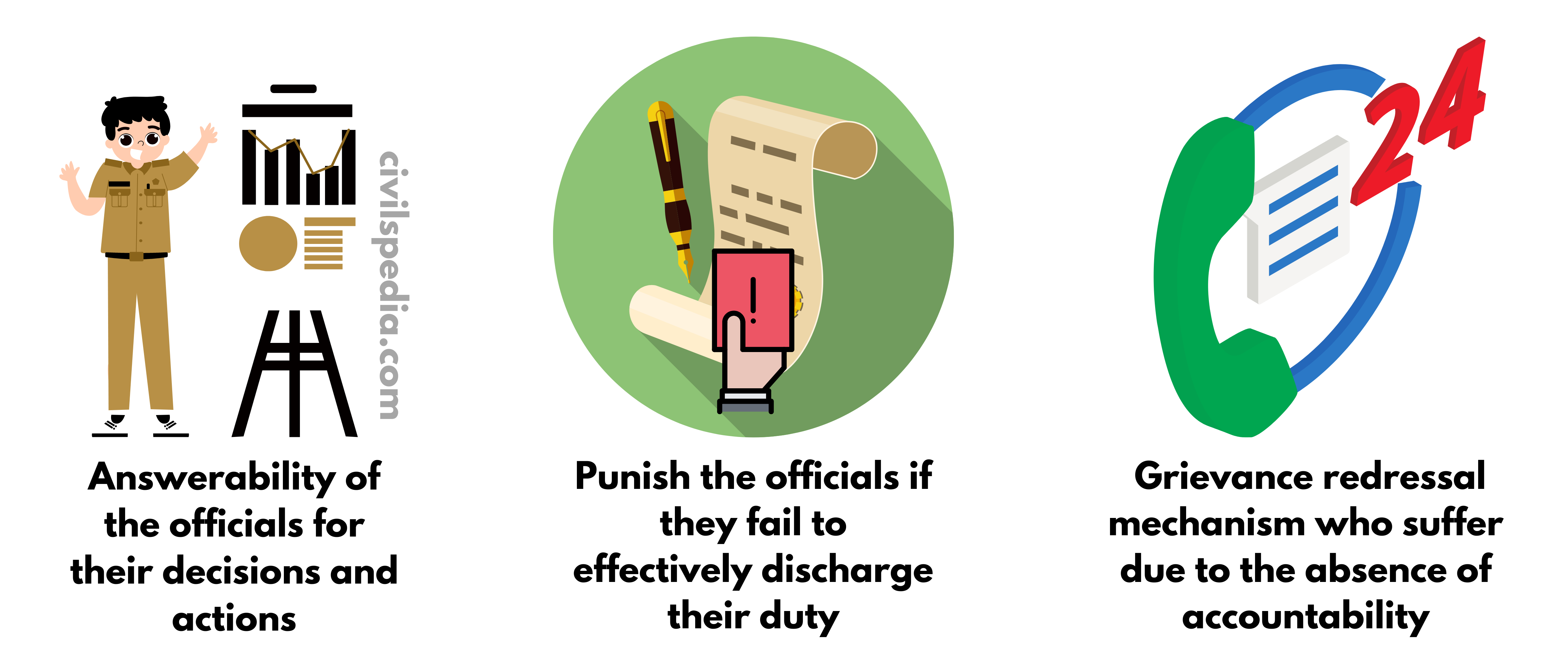
  • Accountability has three aspects 
    1. Answerability of the officials for their decisions and actions
    2. Enforceability of rules and laws to punish the officials if they fail to effectively discharge their duty
    3. Grievance redressal mechanism for the ordinary people who suffer due to the absence of accountability.
  • Accountability is required in the case of Public Servants because they have a lot of discretion.


Benefits of Accountability 

  • Checks Abuse of power: It prevents the public services from turning into tyrants as they are held answerable for their deeds and misdeeds. 
  • Checks corruption and fraud
  • Lack of accountability decreases the legitimacy of the government
  • Makes the system more responsive: Owing accountability for their actions motivates public servants to discharge their duty with honesty, integrity and efficiency.
  • Stops arbitrary and unauthorized exercise of authority 
  • Ensures better service delivery


Points against Accountability 

  • Officers spend their time maintaining records or answering RTIs.
  • It makes them status-quoist in their conduct in fear of public scrutiny.

Accountability vs. Responsibility

Quite often, Accountability is misunderstood as Responsibility.

  • Responsibility is an inner concept like your responsibility to do some work. 
  • Accountability is an outer concept like your accountability for some work you have done.

Types of Accountability

There can be two types of Accountability in Governance

#1 Vertical Accountability

Accountability of the government to persons outside the government is ensured by

  1. Elections 
  2. RTI
  3. Media & Social Media
  4. Citizens Charter 
  5. NGO & Pressure Groups

#2 Horizontal Accountability

Accountability of Public Institutions/ Servants to the Government

It can be further of two types

External Accountability of Public Servants outside his wing 
1. Accountability of Minister (Executive) to Parliament (Legislature)
2. Judiciary 
3. CAG
4. CVC
5. NHRC  
Internal Accountability of Public Servant inside his wing/department
1. Accountability to Superiors
2. Internal Audit 
3. Grievance Redressal Mechanisms

Whenever we have to answer how to increase Accountability, we must cover all these angles.


Steps to make Accountability more effective in India 

  • Strengthening RTI Act 
  • Protection of Whistleblowers through legislation. 
  • Strong Lokpal Act 
  • Social Audits by local communities and NGOs can enhance accountability in public service delivery, for instance, in MGNREGA.
  • Using Information and Technology: Like maintaining digital records to increase transparency
  • Citizen’s initiative: e.g. Mazdoor Kisan Shakti Sangathan (MKSS) (MKSS, founded in 1990 in Rajasthan, is a social organization working towards increasing accountability in India. MKSS began demanding access to government records in 1994, which led to the creation of the RTI Act in 2005.) 
  • Promoting competition and discouraging monopolistic attitudes among public service sectors. 
  • Need to lay down a statutory Code of Ethics for Civil Services (British Civil Services Code can act as a model.)


Side Topic: Various Examples of Social Accountability

Participatory budgeting In Participatory Budgeting, the citizens directly participate in budget (especially at the local government) formulation and monitoring the execution. Gujarat (Local Governance)
Participatory Planning Beneficiaries of government programs are involved in the planning and design of program components to determine local problems, priorities and solutions. Kerala, Brazil and Bangladesh
Citizen Report Card Participatory surveys that provide quantitative feedback to service providers on the satisfaction levels amongst citizens on the quality of public services Bangalore, Maharashtra (Ukraine and Philippines)
Social Audit Process whereby a government program is audited with the active participation of the program’s intended beneficiaries.  

Success Stories

  1.  People’s Campaign for Decentralized Planning in Kerala: Its success has been attributed to significant financial and functional devolution and the institutional incentives for participation which led to increased representation of hitherto marginalized voices like SCs, STs and women. 
  2. Mazdoor Kisan Shakti Sangathan (MKSS) – a Rajasthan-based grassroots organization, employed ‘social audits’ which break the state’s monopoly over official oversight and legitimize citizen inclusion into hitherto exclusive affairs of the state

Various Challenges to Accountability in India

  • Special Expertise: Public administrators are experts in their specific areas. Hence, it is difficult for outside agencies to surpass them in their areas of specialization & question them.  
  • Massive Expansion of Bureaucracy: It is difficult for the political executive to effectively control the bureaucracy due to the massive expansion of bureaucracy.
  • Lack of Coordination:  The number of agencies has also increased – for example, CBI, CVC, Lokayuktas, SVC etc. without effective coordination. Due to their overlapping jurisdiction and lack of coordination, they cannot hold the public servants accountable.
  • Excessive Constitutional Security offered to Public Servants: Article 311 of the Indian Constitution makes it almost impossible to remove a civil servant.
  • Employees’ Unions: The tendency of employees’ unions to resist managerial action against their members even when they have blatantly violated ethical norms reduces the accountability of employees.
  • Disruption by powerful vested interests: Threats and coercion can make communities hesitant to participate directly and speak up in Social Accountability initiatives. 

Special Economic Zones

Special Economic Zones

This article deals with ‘SEZs (Special Economic Zones) .’ This is part of our series on ‘Economics’, which is an important pillar of the GS-3 syllabus. For more articles, you can click here.


Introduction

SEZs are geographical areas with economic laws different from a country’s general economic laws. Accordingly, they are delineated duty-free enclaves and shall be deemed foreign territories for trade, duties and tariffs. 

India enacted the Special Economic Zones 2005 Act, which provided for establishing, developing and managing the SEZs. The SEZ law also provides for establishing the International Financial Services Centre (GIFT Center) and Free Trade and Warehousing Zones.


Timeline

1965 Export Processing Zone (EPZ) opened in Kandla —> India was the first in Asia to do so
2000 First SEZ announced to attract larger foreign investment.
2005
Parliament passed SEZ Act
2018 Baba Kalyani Report on SEZs published
Present The Government has approved over 400 SEZs, and over 230 have been operational.

Salient Features

Special Economic Zones
  • Duty-free enclaves, i.e. treated as foreign territories for the purpose of trade as far as duties & tariffs are concerned.
  • No requirement for a license for imports 
  • Units must become net foreign exchange earners within 3 years.
  • They are subjected to full customs duty & import policy when they sell their products to the domestic market.
  • FDI = 100% FDI allowed through Automatic Route.
  • Examples: DLF Cybercity (Haryana), Kandla (Gujarat) and Vishakhapatnam (Andhra Pradesh) 


Main Objectives of SEZ

  • Generate additional economic activity
  • Promote exports of goods & services
  • Promote investment from foreign and domestic sources
  • Create employment opportunities
  • Develop Infrastructure facilities

Failed SEZ policy & reasons

1. Lack of Clarity in Policy

  • A number of changes are done at frequent intervals. Hence, there is a lack of stability in policy.

2. Virtually no Income tax benefits now

  • The income tax benefits were neutralized by introducing the 20% Minimum Alternate Tax (MAT) and the 20% dividend distribution tax (DDT) in 2011-12

3. Wrong Location

India chose the wrong locations for SEZ. 

  1. In China, most of the SEZs are located in coastal areas. E.g., Shenzhen.
  2. On the other hand, in India, many SEZs are located in the interior parts, such as Haryana. Even in some coastal states such as Tamil Nadu, SEZs are not located on the coasts. 
SEZs in India vs China

4. Free Trade Agreements

  • SEZs have access to duty-free imports of manufacturing inputs because, technically, they are considered outside the country’s domestic tariff area. But, with India signing Free Trade Agreements with countries where duties on many products are eliminated or reduced substantially, the advantage accruing to SEZs was negated.

5. Absence of complementary Infrastructure

  • Absence of complementary infrastructure like port connectivity via roads or railway lines

6. WTO – Countervailing Duty

  • Tax incentives provided inside SEZs are considered against WTO principles by other nations, and they impose Countervailing Duties on products from Indian SEZs.

7. Custom duty on sending products to the Domestic Market

Today, it is better for you to manufacture in Thailand and get duty-free access to India than to manufacture in an Indian SEZ and face an import duty barrier. It is a considerable deterrent to Make in India. India should be signing an FTA with all the Indian SEZs first.


8. Land Acquisitions

500 Acre for Multisector and 50 Acre for Single Sector is difficult to acquire. Hence, land acquisition is one of the significant hurdles.


9. Labour Laws

Labour laws inside SEZs are equally harsh as the mainland. They can’t fire workers easily, and the Industrial Disputes Act (IDA) applies if the company employs more than 100 workers.


Case Study: Why are SEZs in China doing better than Indian SEZs?

The SEZ Model in India was inspired by China’s SEZs which were critical instruments of its export-led growth. Reasons for better functioning of SEZs in China are

  1. Location: Located close to ports from where it can export easily  
  2. Size: China’s zones are few but huge in size. E.g. Hainan, a province in China, is one complete SEZ covering an area of 33,000 sq. km. Indian SEZs are barely 500 -1000 ha in size.
  3. Laws: China has amazingly business-friendly laws. Corporates must give an employee only one month’s notice before firing him. Contrast that to India, where businessmen must follow a lengthy procedure to fire an employee. 
  4. In China, the thrust of SEZs has been to attract foreign investments and modern technology; in India, the emphasis has been on exports. 

Way forward to improve them

  • SEZs should be allowed to sell within the country without payment of customs duty on the product.
  • Abolition of MAT and DDT (Dividend Distribution Tax). 
  • Provide relaxed labour laws there.
  • Fiscal incentives need to be carefully designed so that it doesn’t violate WTO rules. 


Baba Kalyani Report on SEZ (2018)

  • Instead of giving them blanket general tax holidays, SEZ units should be given tax benefits linked to how many jobs have been created, how much FDI investment attracted, how many goods/ services have been exported etc.
  • SEZs should be converted into Employment and Economic Enclaves (3E).
  • Encourage Domestic Electronics Companies in 3Es so that India can end the Chinese monopoly in the Indian electronics market.
  • Synergise SEZs with CEZs, DMIC, NIMZ , Mega Food Parks etc .
  • Improve connectivity to SEZs.

Rivers of Peninsular India

Rivers of Peninsular India

This article deals with the ‘Rivers of Peninsular India (UPSC notes)’. This is part of our series on ‘Geography’, which is an important pillar of the GS-1 syllabus. For more articles, you can click here.


Introduction

  • Indian Peninsula is traversed by a large number of rivers which have existed for a much longer period than the Himalayan rivers. As such, the peninsular rivers have reached a mature stage and almost reached the base level of erosion. 
  • Due to the low gradient, the velocity and the load-carrying capacity of the river are lowand the rivers form big deltas at their mouths. It is especially observed in the east-flowing rivers pouring into the Bay of Bengal. 
  • But the west-flowing rivers of Narmada and Tapi and those originating from the Western Ghats and emptying their water in the Arabian Sea form estuaries instead of deltas.
  • Some of the rivers also have waterfalls. E.g., The Jog Falls on the Shravati (289 m), Sivasamandram on the Cauvery (101 m) and Dhuandar (15 m) on the Narmada 

Evolution of Peninsular Drainage

  • Geologists think of the Sahyadri-Aravali axis as the primary water divide in the past. 
  • It assumes that the existing Indian Peninsula is the remaining part of a bigger landmass, with the Western Ghats located in the middle of the landmass dividing the entire drainage into two symmetrical parts – one flowing in the east and the other flowing in the west. But the western part of the Peninsula cracked and submerged in the Arabian Sea and disturbed the symmetrical plan of the rivers on either side of the watershed during the early Tertiary period.
  • During the collision of the Indian plate, a second major distortion was introduced in the Peninsular block, and it was subjected to subsidence and consequent trough faulting through which now flow the main west-flowing Peninsular rivers, i.e. the Narmada and the Tapi. 

Direction of flow

Although the general direction of flow of the Peninsular Rivers is from west to east, a careful study reveals at least three main directions of flow.

  1. Cauvery, Krishna, Godavari, Mahanadi and several smaller rivers drain southeast into the Bay of Bengal.
  2. Narmada, Tapi and several small streams originating from the Western Ghats flow westward into the Arabian Sea.
  3.  Chambal, Betwa, Ken, Son, and Damodar (tributaries of Ganga and Yamuna) flow in a north-easterly direction.

Part 1: West-flowing rivers

Rivers of Peninsular India
  • The west-flowing Peninsular Rivers are fewer and smaller than their east-flowing counterparts. 
  • The Narmada and the Tapi are the two main west-flowing rivers (the rest of them are small and swift flowing). This unusual behaviour of these two rivers is explained by the supposition that they do not flow in the valleys formed by themselves but have usurped for their channels two fault planes running parallel to the Vindhyas, which were created by the bending Northern Peninsula at the time of upheaval of the Himalayas. 
  • West-flowing Peninsular rivers that fall into the Arabian Sea do not form deltas but estuaries. It is due to the following reasons.
    1. The west-flowing rivers, especially Narmada and Tapi, flow through hard rocks and can’t form distributaries before they enter the sea.
    2. West-flowing rivers are of small lengths and do not have enough deposits to make deltas, whereas East-flowing rivers have large courses, large sediments & sluggish movement at the end. 
    1. The East Coast is emergent, while the West Coast is submergent
  • They display a parallel pattern of drainage characterised by sharp bending. 


1. Narmada

Narmada River

Origin

  • Western flanks of Amarkantak Plateau in Madhya Pradesh

Length

  • 1310 Km (largest west-flowing river)

Flow

  • After rising from the Amarkantak Plateau, it flows through the rift valley between Vindhya & Satpura ranges.
  • For 1078 km, it flows through Madhya Pradesh. Later, it forms the boundary between Gujarat and Madhya Pradesh for 32 km and between Maharashtra and Gujarat for another 40 km. Finally, it meets the Gulf of Khambhat after travelling for 160 km in Gujarat, forming an estuary.
  • There are several islands in the estuary formed by Narmada, of which Aliabet is the largest.
  • Near Jabalpur (Madhya Pradesh), the world-famous Dhuandhar Falls (15 m) lies on it.

Hydro Projects

  • Various Hydro-projects like Indira Sagar, Sardar Sarovar, Omkareshwar, Bargi and Maheshwar have been constructed on it.

2. Tapi

Tapi River

Origin

  • Near Multai Reserve Forest in the Satpura Range (Madhya Pradesh)

Length

  • 730 km (second largest west-flowing river)

Course of River

  • Tapi originates from Multai Reserve Forest and flows through the plains of Vidharbha, Khandesh and Gujarat, passing through (large areas of) Maharashtra and (small parts of) Madhya Pradesh and Gujarat. 
  • It finally falls into the Gulf of Khambhat near Surat, making an estuary.
  • Note: Almost the whole of its course is below Satpura.  
  • Important industrial area of Surat (famous for the textile industry) and Nepanagar (famous for the paper and newsprint industry) lies in its basin. 
  • It is also known as ‘The Twin or Handmaid of Narmada’. 

Hydro Projects

  • Various Hydro-projects like Hathnur Dam, Girna Dam and Dahigam Weir (in Maharashtra) and Kakrapar Weir and Ukai Dam (in Gujarat) have been constructed on it.

3. Mahi

Mahi River

Origin

  • Vindhya Ranges

Length

  • 533 Km

Course of River

  • After rising from Vindhya Ranges, it flows through Madhya Pradesh, Rajasthan and Gujarat and empties itself in the Gulf of Khambat.

4. Sabarmati

Sabarmati River

Origin

  • Mewar Hills of Aravalli Range 

Length

  • 320 Km

Course of River

  • River Sabarmati forms by the joining of two streams, Sabar and Lathmati.
  • It rises from the Aravalli Range and falls in the Gulf of Khambhat after passing through Rajasthan and Gujarat. 

5. Luni

Luni River

Origin

  • West of Ajmer in Aravalli Range

Length

  • 482 km

Course of River

  • It rises west of Ajmer from the Aravalli range and flows southward.
  • It is unique as it flows through the Thar Desert.
  • It is known as Sagarmati in the upper course.
  • Near Govindgarh, it joins Sarsuti/Saraswati (which originates from Pushkar Lake), and from this confluence, it gets its proper name as the Luni.
  • It is finally lost in Rann of Kachchh. 
  • Note: River is named so because its water is brackish below Balotra.

Rivers rising from the Western Ghats 

  • The Western Ghats are the source of about 600 small streams that run west and ultimately drain into the Arabian Sea. 
  • The Western Ghats receive large rainfall from the southwest monsoons, large enough to feed many streams. Although it consists of 3% of the areal extent of the basins of India, they contain about 18% of the country’s water resources.
  • The hydroelectric potential of these rivers is nearly 9500 MW, of which nearly 5500 MW is operational.
  • Since these streams receive significant water from the monsoons, they drain excess rainwater to the Arabian Sea. Because of the relatively abundant water available in these rivers, some river water diversion programs have also been undertaken. E.g., 
    • Periyar (west-flowing) – Vaigai (east-flowing) diversion project was developed during the British period, shifting excessive water from Periyar to Vaigai. 
    • Kurnool-Cuddapah Canal, which was initially planned for irrigation as well as navigation 
Rivers of Peninsular India

6.1 Mandovi and Zuari (Goa)

  • Mandovi (Mahadayi) and Zuari are the main rivers of Goa.
  • Both originate in the Western Ghats.
  • They finally fall into the Arabian Sea.
  • Famous Dudhsagar Falls lies on the Mandovi River. 
  • Currentlythe Mahadayi river water dispute is going on between Goa, Karnataka and Maharashtra.

6.2 Kalinadi, Sahravati & Netravati (Karnataka)

  • Kalinadi, Shravati and Netravati are the major rivers of Karnataka, which originate in the Western Ghats and fall into the Bay of Bengal.
  • Among them, Shravati is famous for Jog Falls (Gerosoppa Falls), which lies on it.

6.3 Bharatpuzha, Periyar and Pamba (Kerala)

  • Bharatpuzha, Periyar and Pamba are the main rivers of Kerala, originating in the Western Ghats.
  • Periyar River is vital for agriculture and hydroelectric power.
  • Pamba drains into Lake Vembanad.

Part 2: East-flowing rivers

1. Subarnarekha

Subarnarekha River

Origin

  • From Ranchi Plateau in Jharkhand

Length

  • 395 km

Course of River

  • After originating from Ranchi Plateau, it flows southeast and forms a boundary between West Bengal and Odisha.
  • It has a large number of waterfalls on it as it leaves Peninsular Plateau.
  • Finally, it joins the Bay of Bengal, forming an estuary. 

2. Brahmani

Koel 
avilspedia.c 
Shankh

Origin

  • After the confluence of Shankh & Koel rivers at Rourkela, both of which originate from the Chotanagpur Plateau.

Length

  • 800 Km

Course of River

  • Brahmani River forms after the confluence of the Sankh and Koel rivers
  • Finally, it drains into the Bay of Bengal above Paradwip Port, forming a delta. 

3. Mahanadi

Mahanadi River

Origin

  • Northern foothills of Dhankarnaya (Chhattisgarh).

Length

  • 857 Km

Course of River

  • The river originates in the foothills of Dandakaranya and then travels through a saucer-shaped basin called ‘Chhattisgarh Plain’. A number of hills surround this basin, and as a result, it is joined by many tributaries like Ib, Mand, Hasdo and Sheonath on the left bank and Ong, Tel and Jonk on the right bank.
  • Later, it enters Odisha, where Hirakud Dam is built on it.
  • It forms a gorge on reaching the eastern ghats and empties itself in the Bay of Bengal, forming a (birdfoot) delta. Bhubaneshwar is located on the apex of the Mahanadi delta.

Tributaries

  • Left Bank:  Ib, Mand, Hasdo and Sheonath
  • Right Bank: Ong, Tel and Jonk

4. Godavari

Godavari

Origin

  • Trimbak Plateau of Western Ghats near Nashik (Maharashtra)

Length

  • 1465 km (It is the largest Peninsular river and next only to Ganga and Indus Systems)

Other names

  • Vridha Ganga
  • Dakshin Ganga

Course of River

  • From Trimbak Plateau, it flows eastwards till Nashik, from where it leaves the Western Ghats and opens up.
  • Subsequently, it receives a large number of tributaries. These include right bank tributaries like Manjra and left bank tributaries like Penganga, Pranhita (Wardha and Wainganga join to form Pranhita), Indravati, Sabri & Sileru.
  • After Maharashtra, the river enters Telangana and subsequently to Andhra Pradesh. In Andhra, the river divides itself into two streams, i.e. Gautami Godavari and Vashishta Godavari, before pouring into the Bay of Bengal, forming a delta characterised by a number of Paleochannels & Mangroves associated with lagoons.

Tributaries

A large number of tributaries.

Left Penganga, Pranhita (Wardha and Wainganga joins to form Pranhita) ,Indravati, Sabri  & Sileru.
Right Manjra

5. Krishna

Krishna River

Origin

  • Western Ghats near Mahabaleshwar (Maharashtra)  

Length

  • 1400 km (it is the second largest Peninsular river)

Course of River

  • It rises in Mahabaleshwar, and after passing through Karnataka, it enters Andhra.
  • Finally, it merges with the Bay of Bengal, forming a birdfoot delta (Mississippi type). 
  • During the flow, it receives tributaries like Koyna,  Ghataprabha, Malprabha, Bhima, Tungabhadra, and Musi are its important tributaries.
  • It finally meets the Bay of Bengal, forming a large delta.

About Tributaries

  • Koyna is a small tributary but is very famous for Koyna Dam. The Dam was probably the primary cause of the devastating earthquake of 1967.
  • Tungabhadra is formed by the merging of the Tunga and Bhadra rivers.
  • Musi joins Krishna near Wazirabad. The famous city of Hyderabad is located on its banks.

6. Pennar

civilspedia.com 
Pennar

Origin

  • Dandi Durg peak in Karnataka.

Length

  • 597 Km

Course of River

  • After originating from the Dandi Durg peak, it flows northward. 
  • Then it enters Andhra Pradesh and takes an easterly course. 
  • It finally joins the Bay of Bengal, forming a narrow estuary.

7. Kaveri/Cauvery

Kaveri

Origin

  • Taal Kaveri on the Brahmagiri hills, situated in Coorg Plateau

Length

  • 800 Km

Another name

  • Dakshina Ganga or Ganga of the South

Course of River

  • It originates at Taal Cauvery and then flows eastwards to reach the Bay of Bengal. 
  • About 3% of the Kaveri basin falls in Kerala, 41% in Karnataka and 56% in Tamil Nadu.
  • This river is perennial with comparatively lesser fluctuations in flow as its upper catchment area receives rainfall during summer by the southwest monsoon and the lower catchment area during the winter season by the retreating northeast monsoon. 
  • It is one of the best-regulated rivers, with 99% of its irrigation potential already harnessed. Major dams include Krishna Raja Sagar Dam (Mysore) and Mettur Dam. 
  • During the course, it joins various tributaries. These include left-bank tributaries such as Hemvati and Shimsa and right-bank tributaries such as Kabani, Bhavani, Noyil and Amravati. 
  • It finally falls into the Bay of Bengal, a few kilometres above Tiruchirapalli, forming the quadrant Delta in the Thanjavur district of Tamil Nadu.

8. Vaigai

civilspedia.com 
Vaigai

Origin

  • Varushand Hills

Course of River

  • It flows south of Cauvery and lies entirely in Tamil Nadu. It flows through dry channels, tends to get lost intermittently, and reappears on the surface.

Himalayan vs Peninsular Rivers

  Himalayan Rivers Peninsular River
Name These rivers originate from Himalayan mountains covered with glaciers. These rivers originate from the Peninsular Plateau
Basins Himalayan rivers have large catchment areas and basins Peninsular rivers have small catchment areas and basins
Nature of flow Perennial: They receive water from glaciers and rainfall. Seasonal: They are dependent on monsoon rainfall.
Valleys Himalayan rivers flow through deep I-shaped valleys called gorges. Peninsular rivers flow through comparatively shallow valleys.
Type of drainage Antecedent & consequent leading to the dendritic pattern in plains. Superimposed and rejuvenated, resulting in trellis, radial and rectangular patterns.
Stage Himalayan rivers are in their youthful stage. Peninsular rivers have reached maturity.
Meanders Himalayan rivers meander when they enter plains owing to a sudden reduction in speed. The hard rock surface of the plateau permits little scope for the formation of meanders. Hence, these rivers have more or less a straight course.
Deltas and Estuaries Himalayan rivers form big deltas. E.g., The Ganga-Brahmaputra Delta is the largest delta in the world. Some Peninsular rivers, such as Narmada and Tapi, form estuaries. Other rivers such as Mahanadi, Godavari, Krishna and Cauvery form deltas. 

Brahmaputra River System

Last Updated: June 2023 (Brahmaputra River System)

Brahmaputra River System

This article deals with the ‘Brahmaputra River System (UPSC notes)’. This is part of our series on ‘Geography’, which is an important pillar of the GS-1 syllabus. For more articles, you can click here.


Information at Glance

Origin Kailash Range of Tibet
Length 2900 km (total)  
Other names
1. Yarlung Tsangpo (Tibetan name)  
2. Dihang (in Arunachal Pradesh)
3. Brahmaputra (in Assam)
4. Jamuna (in Bangladesh)   
Catchment Area Total: 12 lakh km2
India: 3.21 lakh km2    
Tributaries Left Side Tributaries:  DibangLohit, Dhansiri, Kelong, Kapili , Dikhu

Right Side Tributaries: Kameng, Manas, Raidak, Subansiri , Teesta 

Flow of Brahmaputra

Brahmaputra River System

Flow in Tibet

  • Brahmaputra River originates in Chemyungdung Glacier in the Kailash Range of Tibet. 
  • It traverses eastward longitudinally for 1,200 km in southern Tibet (known as Yarlung Tsangpo in Tibet). In Tibet, it receives water from tributaries (like Raga Tsangpo, Ngangchu, Kyichu etc.)

Flow in India

  • After flowing for 1800 km eastward, Brahmaputra suddenly turns and emerges as a turbulent river after carving out a deep gorge (Dihang Gorge) in the Central Himalayas near Namcha Barwa. Here the river is known as Dihang or Siang. The river enters India in the west of Sadiya Town of Arunachal Pradesh.
  • From Sadiya in Arunachal Pradesh to Dhubri in Assam, the river is navigable, and the Government of India has designated it as National Waterway 2
  • Here also, a large number of tributaries join the Brahmaputra. These include 
Right Bank Tributaries Kameng, Manas, Raidak, Subansiri , Teesta
Left  Bank Tributaries Dibang, Lohit, Dhansiri, Kelong, Kapili , Dikhu
  • Note: Before the terrible floods of 1787, the Teesta was a tributary of the Ganga; however, it changed its path to join the Brahmaputra by heading east.
  • Most of the Brahmaputra’s passage through Assam has a braided course. The river keeps on shifting its channel constantly. It forms many islands, the most important of which is Majauli (the largest river island in Asia, having 144 villages on it)
  • Due to concentrated rainfall during the monsoon months, the river has to carry enormous amounts of water and silt, resulting in disastrous floods in the rainy season. Hence, it is also called a ‘River of Sorrow.’

Flow in Bangladesh

  • At Dhubri, the river takes a southward turn and enters Bangladesh. 
  • It flows for 270 km under the name Jamuna and joins the Ganga. The united stream is known as Padma.
  • Later, Meghna joins Padma on the left bank (Meghna originated in the mountainous region of Assam). The united stream of Padma and Meghna is known as Meghna, which forms a broad estuary before entering the Bay of Bengal. 

Teesta River

  • Origin: Kangse Glacier, Sikkim
  • Teesta River enters Bangladesh after passing through West Bengal & meets Brahmaputra before entering the Bay of Bengal.
  • It is the fourth largest river in Bangladesh after Brahmaputra, Ganga & Meghna.
  • India & Bangladesh have a Water Dispute over sharing of the Teesta waters. After various rounds of dialogue, no consensus has been reached. It is the major source of irritant between Indo-Bangla Relations, which otherwise is a valuable ally of India. 


Side Topic: Barak River

  • Barak River rises in Manipur, then passes through Mizoram & Assam.
  • The famous city of Silchar (Assam) is situated on it. After Silchar, it flows for about 30-odd kilometres & near Badarpur, it divides itself into the Surma and Kushiyara rivers and enters Bangladesh. Surma River then merges with the Meghna River. 
  • It is declared as National Waterway-6 by Govt. of India.
  • India has also proposed the Tipaimukh Dam, which has become a source of conflict between India and Bangladesh. 

Ganga River System

Ganga River System

This article deals with the ‘Ganga River System (UPSC notes)’. This is part of our series on ‘Geography’, which is an important pillar of the GS-1 syllabus. For more articles, you can click here.


Information on Glance

Origin Gangotri Glacier
Length 2,525 km  
Catchment Area 8.61 lakh sq. km
Ganga River System

Origin and Flow of River

Bhagirathi and Alkananda

Origin

  • Ganga originates as Bhagirathi from Gangotri glacier near Gaumukh in the Uttarkashi district of Uttarakhand. 
  • Alkananda joins Bhagirathi at Devaprayag. But before the river reaches Devaprayag, the Dhauliganga, the Pindar, and the Mandakini rivers pour into the Alaknanda. 
  • Below Devaprayag, the combined water of the Bhagirathi and Alaknanda flows under the name of the Ganga. 

The flow of Ganga in Plains

  • Ganga enters plains at Haridwar. 
  • From here, it flows in south and southeast directions for a distance of 770 km to reach Allahabad, where the Yamuna joins it. After that, it passes through the Bihar plains. 
  • It ceases to be known as Ganga as it turns southeast and south of Farraka near Rajmahal Hills. It splits into Padma in Bangladesh and Hugli in West Bengal. 
  • After travelling 220 km further down in Bangladesh, the Brahmaputra (or the Jamuna as it is known here) joins it at Goalundo.
  • Further, it meets Meghna and joins the Bay of Bengal.
  • The Ganga and the Brahmaputra form the largest delta in the world before entering the Bay of Bengal. The delta comprises a web of distributaries and islands covered by dense forests called the Sundarbans. 

Tributaries of Ganga

Numerous tributaries join Ganga, both on the left and the right. Most of them have their origins in the Himalayan Mountains, although some originate from the Peninsular Plateau.

Tributaries of Ganga

Right bank tributaries of Ganga

Right bank tributaries of the Ganga include Yamuna, Son and Damodar.

1. Yamuna

Origin Yamnotri glacier on Bandarpunch peak (Uttarakhand)
Length 1380 km
Important Tributaries – Originating in the Himalayas: Ton
– Originating in Peninsular Plateau: Chambal, Sind, Betwa and Ken
Joins Ganga at Allahabad
Yamuna and its tributary
  • Yamuna is the largest & most important tributary of the Ganga.
  • It originates from the Yamnotri glacier on the Bandarpunch Peak in Garhwal in Uttarakhand (very close to the source of the Ganga). 
  • In the upper reaches, it is joined by many small streams. The most important tributary of Yamuna in the upper reaches is Tons which also rises from Bandarpunch Peak and joins Yamuna at Kalsi, right before Yamuna leaves the hills. 
  • After passing through the Himalayas, it enters the plains. 
  • In the plains, it is joined by Hindon near Ghaziabad. 
  • Yamuna flows southward till Mathura and southeast after Mathura till Allahabad, where it unites with Ganga. 
  • Between Mathura and Allahabad, it is joined by Chambal, Sind, Betwa and Ken (tributaries of Yamuna originating from the Peninsular Plateau). 

Peninsular Tributaries of Yamuna

1.1. Chambal

Chambal and its tributaries
Origin Near Mhow Cantt  in Vindhya Plateau of Madhya Pradesh
Length 1050 km
Flow After originating near Mhow, it takes a north-westerly course through the Malwa plateau.
It then enters a gorge from Chaurasigarh to Kota (96 km long).
After Kota, it takes a north-easterly turn. Furthermore, at Pinahat, it turns east and flows parallel to Yamuna before joining it at Etawah (UP). 
Badland Topography Chambal is known for its Badland Topography because of the extreme erosion caused by the river. 
Badlands are found in MP, Rajasthan & UP & are infested with dacoits.
Tributaries 1. Banas: Originating from Aravali and joining Chambal near Sawai Madhopur. 
2. Kali Sind  (originate from Vindhyas)
3. Parbati (originate from Vindhyas)
Projects 1. Gandhi Sagar
2. Rana Pratap Sagar (Rawatbhata)
3. Jawahar Sagar

1.2 Sindh

Sindh River
Origin Vindhya Plateau
Length 415 km
Flow  After passing through MP, it joins Yamuna in UP.

1.3 Betwa

Betwa River
Origin Bhopal district
Length 590 km
Flow After passing through MP, it joins Yamuna near Hamirpur in UP.

1.4 Ken

Origin Barner Range of Madhya Pradesh
Length 360 Km
Flow The river passes through the Panna district of MP & makes a gorge at Gangau.
It joins Yamuna in the Banda district in UP.
Yamnotri 
Glacier Gangotri 
Tons 
Yamun 
Glacier 
Allahabad 
Ken 
civilspedia.com 
Hooghly 
Padma

2. Son

Son River
Origin Amarkantak plateau in Chhattisgarh
Length 780 km
Flow The river originates in the Amarkantak Plateau and flows in the north direction.
From the Kaimur range, it takes a northeast turn and passes through the Palamau district of Jharkhand.
Later, it joins Ganga in the Patna district of Bihar. 
Waterfalls Son River forms waterfalls when it leaves the plateau.
Important tributaries Rihand (from Ramgarh Hills)
North Koel (from Chotanagpur Plateau)

3. Damodar

Damodar River
Origin Chotanagpur Plateau
Length 780 km
Flow After originating from the Chotanagpur Plateau, it flows through the rift valley.
It used to cause devastating floods and earned the name of ‘Sorrow of Bengal.’ 
It finally joins Hooghly in West Bengal, 48 km below Kolkata.
Points India’s first multipurpose river project Damodar Valley Corporation (DVC) located on it with Tilaiya, Maithon & Panchet dams
Damodar Valley is rich in coal deposits & called the Ruhr Valley of India.

Left bank tributaries of Ganga

Left bank tributaries of Ganga include Ramganga, Gomati, Ghaghra, Gandak, Kosi and Mahananda.

1. Ramganga 

Ramganga  River
Origin Garhwal district of Uttarakhand
Length 596 km
Flow Ramganga rises in the Garhwal district of Uttarakhand and enters Ganga plain near Kalagarh.
It finally joins Ganga at Kannauj. 

2. Gomati

Gomati River
Origin Northern UP
Flow After entering the Ganga plains, it passes through Lucknow and finally meets Ganga. 

3. Ghaghra

Gangotri 
Glacier 
Ghaghra 
Ganga 
Hooghly 
civilspedia.com 
Padma
Origin Near Gurla Mandata peak (south of Mansarovar Lake) in Tibet
Length 1080 km
Flow It originates in Tibet. Then it flows through Nepal, where it is known as Karnali.
After entering the plains, it is joined by important tributaries like Sarda, Sarju and Rapti. Ayodhya is located on the banks of river Sarju.
It finally meets Ganga in the Chhapra district of Bihar. 
The river has a high flood frequency and has shifted its course several times. 

4. Gandak

Gandak River
Origin Near Tibet-Nepal Border.
Length 435 km
Flow It originates near the Tibet-Nepal border and receives water from a large number of tributaries in Nepal like Kali Gandak, Bari, Trishuli etc. 
It finally enters the plains and joins Ganga at Hajipur (near Patna) in Bihar.

5. Kosi

Gangotri 
Glacier 
Ganga 
Sorrow of Bihar 
Kosi 
Hooghly 
Padma 
civilspedia.com
Origin Tibet
Length 730 km
Flow Kosi originates in Tibet as Sapta Kosi (i.e. made up of 7 streams in Tibet).
Gradually, tributaries join and are reduced to 3 streams in Nepal, known as Triveni.
These three streams merge & known as Kosi when it enters India.
– It enters into the plain region just when it enters India, carrying a lot of sediments & has a large volume of water. Due to sediments, the depth of the basin becomes shallow and the river becomes sluggish, making the braided river channel which shift its course frequently. Due to this, it results in frequent devastated floods and the river is known as the ‘Sorrow of Bihar‘.
But it has been tamed since 1962 by constructing embankments on its rivers.

6. Mahananda

Mahananda River
Origin Darjeeling Hills
Flow After entering the plains, it joins the Ganga as its last left bank tributary. (NCERT fact)

Indus River System

Indus River System

This article deals with the ‘Indus River System (UPSC notes) ’. This is part of our series on ‘Geography’, which is an important pillar of the GS-1 syllabus. For more articles, you can click here.


Himalayan River Systems

  • There are three major Himalayan River Systems, i.e. the Indus, the Ganga and the Brahmaputra. 
  • Many Himalayan rivers existed even before the Himalayan ranges were uplifted, corroborated by the gorges of the Indus, the Satluj, the Kosi, the Brahmaputra, the Gandak, the Alkananda etc. It is believed that they continued to flow all through the building phase of the Himalayas; their banks rose steeply while the beds went lower and lower, thus cutting deep gorges through the rising Himalayan ranges. Therefore, many of the Himalayan rivers are typical examples of antecedent drainage.

Indus System

Information at Glance

Origin Bokhar-Chu Glacier of Tibet
Other Names Singhi Khamban (in Tibet)
Sindhu (Hindi and Sanskrit)
Sinthos (Greek)
River Type Antecedent
Length Total: 2,880 km
India: 709 km
Catchment Area Total: 2,880 km
India: 709 km
Tributaries – Left Side Tributaries: Zaskar, Jhelum, Chenab, Satluj, Ravi, Beas, Soan, Dras and Suru

– Right Side Tributaries: Shyok, Nubra, Gilgit, Kabul Sakardu, Gomal, Hunza, Khurram, Shigo etc.
Indus River System
  • Indus, along with its tributaries, forms one of the largest drainage systems in the world. It is from this river that India got her name.
  • River Indus originates at Bokhar-Chu Glacier of Tibet.
  • In Tibet, Indus is known as ‘Singhi Khamban’ or Mouth of Lion.

Indus in India

  • It enters India and continues to flow in the northwest direction between the Ladakh and the Zaskar Ranges. Here it encircles the town of Leh and is joined by the Zaskar River. Later, Suru (an obsequent tributary on which Kargil lies) joins the Indus. Subsequently, it is joined by the Shyok (origin: Siachin Glacier). Gilgit is the last tributary of the Indus in India.

Indus in Pakistan

  • Near Attock, it takes a sharp southerly bend and ends its mountainous journey after passing through a deep gorge. Here it is joined by the Kabul River from Afghanistan. 
  • After that, it flows through the Potwar Plain and crosses Salt Ranges. Some important tributaries like Kurram, Tochi, Sohan and the Zhob-Gomal join the Indus River here. 
  • Indus joins Panjnad (in Punjabi) or Punchnad (in Hindi), i.e. accumulated waters of the five eastern tributaries- Jhelum, Chenab, Ravi, Beas and Satluj near Mithankot, about 805 km from the sea.
  • After forming a big delta, Indus finally empties itself into the Arabian Sea, south of Karachi. 

Main Tributaries of Indus

The 5 main tributaries of the Indus are big rivers in themselves and deserve a brief mention here. These rivers join together one by one before they ultimately meet the main river.


1. Jhelum

Origin

  • Verinag in Pir Panjal Range

Length

  • 724 Km

Other Names

  • Vitasta (Ancient/ Vedic Name)
  • Neelam (in Pakistan)

Flow

  • Initially, it flows northwards till Wular Lake and further in the southwest direction to flow through the Kashmir Valley.
  • At Muzaffarabad, Jhelum joins Kishenganga and takes a sharp hairpin southward swing.           
  • After that, it forms a border between India and Pakistan for 170 km and emerges at Potwar Plateau at Mirpur. 
  • Finally, it joins Chenab at Trimmu. 

2. Chenab

Origin

  • Near Bara Lacha Pass 

Length

  • 1,180 Km

Other names

  • Askini (Vedic name)
  • Chandrabhaga (in Himachal Pradesh)

Important points

  • It is the Indus River System’s largest tributary.

Flow

  • Two small streams on opposite sides of the pass, namely Chandra and Bhaga, combine to form Chandrabhaga. Chandrabhaga flows in the northwest direction and enters Jammu and Kashmir as Chenab after cutting a deep gorge.
  • After passing through Kashmir, the river enters Pakistani Punjab.
  • Later, it joins Jhelum and Ravi and finally meets Satluj to form Panchnad.

Projects on the river

  • Projects on Chenab include Salal, Baglihara and Dulhasti Projects.

3. Ravi

Origin

  • Kullu Hills near Rohtang Pass (Himachal Pradesh).

Length

  • 725 km

Other Names

  • Purushini (Vedic name)

Flow

  • Initially, it flows in a northwest direction. 
  • After crossing Chamba, it takes a south-westerly turn and leaves the Dhaula Dhar range making a deep gorge.
  • It enters Punjab at Madhopur, and after passing through Punjab, it enters Pakistan 26 km south of Amritsar.
  • In Pakistan, Lahore is situated on its banks. Harappa is also situated on the banks of Ravi. 
  • It meets Chenab near Rangpur in Pakistani Punjab.

Projects on the river

  • Ranjit Sagar, Chamera and Baira Siul.

4. Beas

Origin

  • Beas Kund near Rohtang Pass at the southern end of Pirpanjal (Himachal Pradesh)

Other Names

  • Vipasa (Vedic name)

Length

  • 465km

Flow

  • It originates near Rohtang Pass near the source of Ravi.
  • It enters Punjab forming a deep gorge from Lorji to Talwara. From here, it takes a deep south turn to enter the plains.
  • Finally, it joins Satluj at Harike (Ramsar Wetland).

Projects on the river

  • Pong Dam & Pandoh Dam

5. Satluj

Origin

  • Rakas Lake near Mansarovar; enters India through Shipki la pass.

Other Names

  • Satudri (Vedic name)
  • Langchen Khambab (Tibetan name)

Length

  • 1050 km (in India)

Important Point

  • It is an antecedent river

Flow

  • After originating near Mansarovar, it flows through Tibet and enters India at Shipki La Pass, forming a deep gorge.
  • In Himachal, it joins a number of small tributaries. The most important among these is Spiti.
  • It enters the Punjab plains after forming a gorge at Naina Devi, where the famous Bhakra Dam has been constructed.
  • At Ropar, it turns westwards and meets Beas at Harike. Further, it keeps on flowing westward and forms a boundary between India and Pakistan at Ferozepur.
  • In Pakistan, it meets Chenab. The combined waters of the five rivers of Punjab thus formed is known as Panchnad.
  • Panchnad meets Indus at Mithankot.

Projects on the river

  • Bhakra Project and Naphtha Jhakhri

Indus Water Treaty

  • After partition, Indus Water Sharing  Treaty was signed in 1960 between India & Pakistan (under the aegis of the World Bank).
    1. Pakistan was given: Indus, Jhelum & Chenab.
    2. India was given: Ravi, Beas & Sutlej.
    3. India is permitted limited use on rivers granted to Pakistan, such as drinking water, existing agriculture use, limited expansion, storage of no more than 3.6 MAF (million-acre feet), and hydroelectricity generation through run-of-the-river projects.
    4. But the condition is India can’t divert the water of these rivers.
  • This treaty is hailed as one of the most significant diplomatic achievements of both nations because water sharing is a very sensitive issue, and no other Asian Nation has been able to sign such a treaty.

(For more details – CLICK HERE)


Ghaggar

  • Ghaggar rises from Talus fans of Shivalik in Sirmaur near Ambala. 
  • After entering the plains, it disappears & again reappears at Karnal. Further on stream is called Hakra, which gets lost in the Hanumangarh district.
  • The considerably large size of this river bed, i.e. 5 to 8 km wide with loamy soil in the river bed led to the belief that in old times Satluj might have flowed south to join Ghaggar- Hakra & this was a much bigger river known as Saraswati in Vedic literature.

Thar Desert

Thar Desert

This article deals with ‘Thar Desert (Geomorphology of India).’ This is part of our series on ‘Geography’, which is an important pillar of the GS-1 syllabus. For more articles, you can click here.


Main Features of Thar Desert

Thar Desert
  • Thar desert is the 9th largest desert in the world. 
  • It lies to the west of Rajasthan Bangar. 
  • t is a region of undulating topography with the presence of movable longitudinal sand dunes called the “Dhrian“. 
  • The region receives deficient rainfall below 150 mm annually. Hence, an arid climate with low vegetation cover is found here. Thar desert is also known as Marusthali due to this. 
  • It is believed that this region was under the sea during the Mesozoic era. It can be corroborated by the evidence available at the wood fossils park at Aakal and marine deposits around Brahmsar, near Jaisalmer. 
  • Although its surface features have been shaped by physical weathering and wind, its underlying rock structure is an extension of the Peninsular plateau. Mushroom rocks, shifting dunes, and oasis are prominent desert land features found here (primarily in its southern part). 
  • The majority of the rivers in this area are ephemeral. Luni River flowing in the Southern part is of significance. It is a water deficit zone because of the high evaporation and low precipitation. There are some streams that, after flowing for a while, dry up and join a lake or playa, presenting a typical example of inland drainage. The brackish water of lakes or playas is also the primary source of salt.
  • This region is also famous for Great Indian Bustard, found in the Great Indian Desert Park (near Jaisalmer).


Side Topic: Playa Lake 

  • Depression in deserts is filled with water occasionally. It evaporates later, leaving behind salts & minerals. The cycle of deposition & evaporation goes on & is a source of
    • Borax. 
    • Gypsum. 
  • Examples of Playas include Pokharan, Thob etc.

Water evaporates 
leavin behind salts 
an minerals

The Peninsular Plateau

The Peninsular Plateau

This article deals with ‘The Peninsular Plateau (Geomorphology of India).’ This is part of our series on ‘Geography’, which is an important pillar of the GS-1 syllabus. For more articles, you can click here.


Introduction

  • Peninsular Plateau is the largest physiographic unit of India, stretching from Aravallis in the north-west to the Shillong plateau in the north-east and Kanyakumari in the south. It is triangular in shape. 
  • It occupies 50% of the Indian landmass, consisting of numerous small plateaus and mountains measuring around 16 lakh square km. 
  • It is an ancient tabular block containing Archean Gneiss, Schist and the Dharwar rock system. In the Deccan plateau, igneous Basalt rocks are also found.
  • It is among India’s oldest and most stable landmass. It has undergone minimal structural changes since its formation. It has never been submerged beneath the sea except in the few places where marine transgressions have been made, and that too locally. Along with that, it has not experienced any tectonic activity except for Bhima Fault formed along the Bhima river.
  • Due to old age, the rivers in this region attained their base level and developed broad and shallow valleys. 
  • Plateau’s general elevation is from west to east, also vouched by the river movement (except in the Narmada-Tapi rift valley).

It’s formation

  • The entire peninsular plateau was formed during the pre-Cambrian era, i.e., 500 MYA (Million Years Ago).
  • Later, the Indo-Australian plate (containing Peninsular Plateau) started to move towards the Eurasian plate. Around 70 MYA during the tertiary period, it passed over the Reunion hotspot, and highly fluid basaltic lava broke through the surface, forming a basalt flood province called Deccan Traps. 

Division of Peninsular Plateau

The Peninsular Plateau

The entire Peninsular Plateau consists of several smaller plateaus and hill ranges.

Plateaus 1. Marwar Upland
2. Central Highland
3. Bundhelkhand Upland
4. Malwa Plateau
5. Baghelkhand
6. Chotanagpur Plateau
7. Meghalaya Plateau
8. Deccan Plateau
9. Chhattisgarh Plains
Hill Ranges 1. Aravalli Range
2. Vindhya Range
3. Satpura Range
4. Western Ghats
5. Eastern Ghats

1. Plateaus

1.1 Marwar Plateau

  • Marwar Plateau is situated in eastern Rajasthan, east of the Aravalli mountain range. 
  • Average elevation varies between 250-500 meters above sea level.
  • Marwar Plateau mainly consists of sandstone limestone and shale.
  • It is a rolling plain due to erosional activities carried out by the Banas River. [‘Rolling plains’ aren’t flat, and there are slight rises & falls)
  • The Peninsular plateau’s extension may be seen as far as Jaisalmer in the west, where sand dunes have covered it.

1.2 Malwa Plateau

  • It lies in the north-western part of the Peninsular Plateau. It lies to the south-east of Aravallis and north of Vindhyachal Range. 
  • Chambal, Betwa and Ken drain the Malwa Plateau before joining the river Yamuna.
  • It consists of an extensive lava flow, thus covered with black soils.
  • It is devoid of vegetation, and due to gully erosion by rivers like Chambal, deep ravines have developed, and the region has been made unfit for agriculture, converting it into Badlands

1.3 Bundhelkhand

  • It is a part of the Peninsular Plateau, which extends east of the Malwa Plateau and is known as Bundelkhand.
  • It lies in Madhya Pradesh & Uttar Pradesh.
  • It has an average elevation of 300-600 m 
  • It is made up of Granite & Gneiss rocks.
  • It is a drought-prone region.
  • River streams such as Betwa and Ken flow through it. The erosional work of these rivers has converted this region into an undulating (wave-like) area.


1.4 Bagelkhand

  • Bagelkhand lies to the east of Bundelkhand. 
  • It is made up of limestone and sandstone.
  • It is drained by Son and Mahanadi rivers.  
  • The general elevation is between 150 m to 1,200 m.

1.5 Chotanagpur Plateau

  • It is the North-East projection of the Peninsular Plateau. 
  • It covers the state of Jharkhand & surrounding areas of Odisha, West Bengal, Chhattisgarh & Bihar.
  • It is composed mainly of Gondwana rocks with patches of  Archean Gneiss and Schist and Deccan Lava. Hence, it is rich in both metallic minerals as well as coal. 90% of India’s coal reserves are in this region, and hence it is called the ‘Ruhr of India’. 
  • River Damodar divides the Chotanagpur Plateau into two parts. The northern part is known as Hazaribagh Plateau, while the southern part is known as Ranchi Plateau.
  • The North-Eastern edge of the Chotanagpur plateau is made up of Rajmahal hills. These are made up of basalt (lava flow). These hills have an elevation of up to 400 m.
  • This region has a ‘Radial type of drainage‘. Following rivers originate and flow radially outwards from the Chotanagpur Plateau. The rivers include
    • Damodar
    • North Koel
    • South Koel
    • Subarnarekha 
    • Barkar 
Chotanagpur Plateau

1.6 Chhattisgarh Plain

  • The Chhattisgarh Plain is the only plain region in the Peninsular plateau that is worth naming.
  • It lies between Maikal Range and Odisha Hills. 
  • It is saucer-shaped and is drained by the Mahanadi River.
  • The general elevation is between 250-330 m. 


1.7 Deccan Lava Plateau

a. Maharashtra Plateau 

  • It lies in Maharashtra and forms the northern part of the Deccan Plateau.
  • It is formed due to fissure eruption and lava flow. Hence, most of the rocks of this region are basaltic rocks of lava origin.
  • It has ‘step-like topography‘ due to horizontal lava sheets. Hence, it is also known as ‘Deccan Traps.”
  • Maharashtra Plateau has ‘Black Soil’, also known as ‘Regur’. It is well suited for the cultivation of Cotton.
  • Important rivers of south India like Godavari, Bhima, Krishna, Vardha and Venganga flow through it. The erosional activity of these rivers has converted the region into a number of shallow and broad valleys flanked by flat-topped steep-sided hills and ridges. E.g., Godavari flows between Satmala and Balaghat.
Maharashtra Plateau

b. Karnataka Plateau

  • It lies to the south of the Maharashtra plateau. 
  • It is also known as Mysore Plateau.
  • The general elevation is between 600-900 m.
  • It is primarily made up of Archean formations.
  • Karnataka plateau has two parts, Malnad and Maidan.
    1. Malnad means ‘Hilly and Forested land.’
    2. Maidan means ‘plains’. It is a rolling plain made up of granite. 
 Karnataka Plateau
  • The famous Baba Budan hills lie in the Malnad region, and it is renowned for its coffee plantation (the famous Café Coffee Day chain is based here).
  • The region is highly dissected by the fast-moving rivers emerging from the Western Ghats.
  • River Kaveri originates from the Malnad. It jumps from Malnad to Maidan to make the famous Shivsamudram Falls. Here, river Kaveri has two islands, i.e. Shivsamudram Island and Srirangapatnam Island (famous for the Treaty of Srirangapatnam). The lake between the two islands is known as Ranganathitoo Bird Sanctuary. Due to excessive water, the Shivsamudram region is famous for sugarcane.
  • River Tungabhadra (a tributary of Krishna) also originates from the Malnad region. 
 Karnataka Plateau

c. Telangana and Rayalaseema Plateau

  • It is made up of Archean Gneiss with an average elevation of 500-600 m.
  • This region is semi-arid as it lies in the rain-shadow zone of the western and eastern ghats.
  • It is a highly dissected region by the rivers passing through this region, i.e. Godavari, Krishna and Penneru.

d. Dandakaranya Plateau

  • It is the mineral-rich region of Chhattisgarh and Odisha, touching parts of Maharashtra.
  • It is drained by the Indravati river.
  • Richest mines of India are found in Dandakaranya Plateau
  • It is badly affected by naxalism and is a part of the ‘Red Corridor.’

1.8 Meghalaya Plateau

Garo 
Mikir - Rengma 
Khasi Jaintia
  • It is the north-east extension of the Peninsular Plateau.
  • It is separated from the Peninsular Plateau by Rajmahal -Garo Gap / Malda Gap. It is formed by the down-faulting, which was later filled by the sediments of river Ganga and its tributaries. 
  • This region is made up of Dharwar rocks of the Archean Rock System, shales and schists with granite intrusions.
  • Coal, iron ore, sillimanite, limestone, uranium, and other minerals are abundant in the Meghalaya Plateau.
  • The Meghalaya Plateau is divided into numerous hills such as Garo, Khasi, Jaintia, Barail and Mikir Rengma (Karbi-Anglong Plateau). Out of all, Khasi is the highest. Shillong, situated in the Khasi hills, is the highest point of the Meghalaya Plateau.
  • This region receives ample rainfall from the south-west monsoon. The Meghalaya plateau has severely degraded as a result. Chirapunji exhibits a barren rocky surface devoid of any vegetation.


2. Mountains

2.1 Aravallis

No Rainfall as 
Aravallis are parallel 
Aravalli
  • Aravallis are one of the oldest fold mountain ranges of the world which rose during the Precambrian event called Aravalli-Delhi orogeny. It is a classic example of the relic mountains that have been denuded now to form discontinuous ranges.
  • Aravalli literally means ‘line of peaks’.
  • These hills extend from Gujarat (Palanpur near Ahmedabad), through Rajasthan and Haryana, to Delhi in the north-westerly direction for a distance of about 700 km. 
  • Aravallis are a source of water for Sabarmati, Luni and Banas.
  • The Great Boundary Fault separates Aravalli from Vindhya.
  • It is facing erosion at great speed, and erosion is an environmental concern because it checks the spread of the Thar desert.
  • The height of the Aravallis is greater in the south and reduces while moving from south to north. The height is about 1,500 m in the south-west, while near Delhi, the height is hardly 400 m. (Highest Peak= Guru Shikhar in Mt Abu is situated in southern Aravallis).
  • Due to the direction of Aravallis from south-west to north-east, they don’t act as barrier to the Arabian Sea Branch of the South-West monsoon. Hence, the western part of Rajasthan is arid and semi-arid. 
  • Aravallis are rich in metallic minerals (Archean rocks) and marbles (Vindhyan sediments).

Issue: Erosion, Mining and Encroachment of Aravallis

  • In the news, because of illegal mining and construction of illegal colonies and buildings in the Aravallis.

Significance of Aravallis

  • Combating Desertification: It checks the spread of the Thar desert into the Great Plains.
  • Water Divide: The Aravalli acts as a water divide between the Indus and Ganga river systems. 
  • Enhanced Precipitation: Aravallis enhances the precipitation in the area and checks drought.
  • House of Biodiversity: The area is a rich habitat for biodiversity and houses 10 carnivore species.
  • Aravallis are an important source of resources and minerals.
  • Important drainage systems like the river Sabarmati and Luni originate from Aravallis.

Issues

  • Deforestation: Supreme Court, in the matter of M C Mehta vs Union of India (2004), acknowledged that Aravallis are in a bad state due to illegal and unplanned deforestation.
  • Mining: In the 2018 Judgement, Supreme Court commented that 31 out of 128 Aravalli hills in Rajasthan have disappeared due to illegal mining activities.
  • Unplanned Urbanization: Due to rapid Urbanisation, illegal colonies are being cut in Aravallis, especially near the NCR region.

Outcome

  • Desertification: Sand dunes are approaching the NCR region and parts of Gangetic plains due to the disappearance of effective barriers in the form of Aravallis. 
  • Pollution in Delhi: Supreme Court (2018), in its verdict, blamed the disappearance of the Aravalli Hills as one of the reasons for rising pollution in Delhi. 
  • Human-Animal Conflict: Instances of Human-Animal conflict have increased. For example, wild animals (like leopards) are venturing into human habitations in Gurgaon. 
  • Limited Seasonal Rain: Earlier, the hills accelerated seasonal rainfall in the nearby areas. The degradation in hills has decreased the amount of seasonal rainfall to a minimal, transforming land into a barren desert.

2.2 Vindhyachal Mountain Range

  • It extends from Gujarat (Jobat) to Bihar (Sasaram).
  • It has an average elevation of 450 to 600m.
  • It is a BLOCK MOUNTAIN formed due to rifting. The southern boundary of the Malwa Plateau has escarped downwards due to faulting, and as a result, a block mountain and rift valley have formed. Vindhya is the block mountain (horst), while in the adjoining rift valley (graben), the Narmada river flows towards the west.
  • Vindhyas act as the ‘Water divide of India.’    
  • It is a source of many north-flowing rivers like Chambal, Sindh, Betwa & Ken ( tributaries of Yamuna).
  • It contains limestone and marble (property of the Vindhyan System of rocks).
  • Kaimur Range is an extension of Vindhyas.


2.3 Satpuras 

  • Satpuras are a series of seven-block mountains (Sat = 7 and Pura = Mountains). It is not a continuous range in contrast to Vindhyas. 
  • They run in the west-to-east direction, starting from Rajpipla Hills (Gujarat) to Gawilgarh (Maharashtra), followed by Mahadev Hills (Madhya Pradesh)and ending with the Maikal Hills (Chhattisgarh). 
  • It runs through Gujarat, Maharashtra, Madhya Pradesh and Chhattisgarh. 
  • It forms the boundary between Maharashtra and Madhya Pradesh and between Maharashtra and Gujarat.
  • Dhupgarh near Panchmarhi in Mahadeo Hills is the highest peak of Satpuras. 
  • Important rivers like Narmada, Son and Tapi originate from Satpuras.
    • Narmada and Son originate from Amarkantak 
    • Tapi originates from a place known as ‘Multai’.
    • Narmada flows in the rift valley between Vindhyas and Satpuras, while Tapi flows south of Satpuras.
    • Both Narmada and Tapi are west-flowing rivers in contrast to all other peninsular rivers, which are east-flowing.
  • Amarkantak, situated in the Maikal Hills of Satpura, is important as 
    • Rivers Narmada and Son originate here. It represents an example of ‘radial drainage’.
    • Famous Amarkantak Biosphere Reserve (famous for Tigers) is situated here.
  • Important fauna of the region includes Tigers, Elephants, Barasingha, Black Panther etc.
  • Important tribes of the Satpuras include Khonds, Mundas and Bhils. 
  • It has great economic importance.
    • Tropical Deciduous Forests of Satpura provide the best grade teak in the world apart from Sal and Tendu (minor forest produce).
    • The paper industry of India is concentrated in this region. Vallabhgarh, which is the largest paper mill in Asia, is situated in this region.


2.4 Western Ghats

Western Ghats
  • The Western Ghats are Block mountains as the western coast of India has escarped downwards below the sea due to faulting.
  • It runs continuously from Tapi Valley in Gujarat to Kanyakumari. But some passes are present in the Western Ghats.
  • The average height is greater in the southern part than in the northern part. 
  • The western side of the Western Ghats is very steep, but the eastern part is gentle because of traps/ lava flow.
  • Western Ghats are 
    1. World Heritage Site declared by UNESCO
    2. Biodiversity Hotspot as declared by Conservation International
    3. Eco-Sensitive Zone declared under Environment Protection Act. 

It can be subdivided into the following parts

1. Sahyadri

  • The northern part of the Western Ghats, having a horizontal sheet of Deccan lavas, is known as Sahyadri.
  • Mt Kalsubai is the highest peak in this region.
  • Rivers such as Godavari, Bhima and Krishna originate from the Sahyadri ranges.
  • There are two important gaps, i.e. Thalgat gap (connects Mumbai with Nashik) & Bhorghat gap (connects Mumbai with Pune). 

2. Middle Section

  • The middle section runs through Karnataka up to the Nilgiris.
  • It is made up of granite and Gneiss presenting the rougher topography.
  • The important peaks here are Baba Budan Hills. 
  • It is the source of the river Kaveri.
  • Nilgiris, part of Western Ghats, forms the junction between Western and Eastern Ghats. This region is important as 
    • The important hill station, i.e. Ooty, is situated in Nilgiris.
    • Nilgiris derive their name from a flowering plant, ‘Neel Kurunji,’ which grows in Shola forests in the Western Ghats.
    • Nilgiri biosphere reserve is situated here. It consists of the region of Southern Karnataka, Tamil Nadu and Kerala. 
    • Nilgiri is famous for Rajiv Gandhi National Park (Kr), Bandipur National Park or Tiger Reserve, Talaimalai National Park, Wayanad Wildlife Sanctuary, Madumalai National Park, Silent Valley National Park (Kerala). 
    • Nilgiris have unique vegetation as in the lower reaches, Tropical Evergreen Forests are found, while in the higher reaches, Temperate Forests known as Shola Forests are found. 
    • Nilgiri Biosphere Reserve is also a junction of the Tropical Evergreen Forest (western Ghats) and Tropical Deciduous Forests at Satyamangalam National Park
    • Endemic Species of Nilgiris include Lion Tailed Macaque, Nilgiri Tahr, Malabar Giant Squirrel, and Malabar Civet.
    • Nilgiris has a plantation of Coffee, Tea, Rubber etc. Due to plantation agriculture, there is an increase in Invasive Alien Species, especially Eucalyptus, Wattle and Lantana (Congress Grass) etc.
  • Nilgiri is separated from the Southern Hill complex by Palghat Gap. Palghat Gap allows moist winds of South-west monsoon to penetrate to Mysore plateau. The Palghat gap is also a connecting link between Kerala and Tamil Nadu.

3. Southern Hill Complex

  • It consists of Annamalai Hills, Palani Hills and Cardamom Hills.
  • Anaimudi, situated in Annamalai hills, is the highest peak of the Peninsula. It is famous for Indira Gandhi Tiger Reserve. It is also known as Topslip.
  • Famous hill stations, like Munnar in Annamalai Hills and Kodaikanal in Palani Hills, are also situated here.
  • Cardamom Hills is the southernmost branch, and it is famous for spices. 
  • The famous Sabarimala Temple lies in the Cardamom hills.

2.5 Eastern Ghats

Eastern Ghats
  • The Eastern Ghats are a series of discontinuous hills starting from the Vaigai river in Tamil Nadu to the Mahanadi River in Odisha.
  • There is no structural and geological homogeneity. All the hills have formed in different geological events. 
  •  Eastern Ghats consists of (from south to north)
    • Shevaroy and Javadi in Tamil Nadu
    • Palconda and Nallamalai in Andhra Pradesh 
    • Garjat in Odisha
  • They are cut by four major rivers of South India, i.e. Godavari, Krishna, Kaveri & Mahanadi.
  • Eastern Ghats are much older than Western Ghats.
  • They are not as high as the Western Ghats. 
  • The highest peak of Eastern Ghats is Mahendragiri (in Garjat Hills) 
  • They receive lesser rainfall than the Western Ghats. Hence, the vegetation of this region is Tropical Deciduous.  

The Great Northern Plains

The Great Northern Plains 

This article deals with ‘The Great Northern Plains (Geomorphology of India).’ This is part of our series on ‘Geography’, which is an important pillar of the GS-1 syllabus. For more articles, you can click here.


Introduction

  • Northern Plains are the ‘aggradational plains‘ or ‘depositional plains‘ formed by the depositional works of three major Himalayan river systems viz, the Indus, the Ganga and the Brahmaputra. 
  • It extends from the foothills of the Himalayas to the northern edge of the Peninsular Plateau.
  • Surface features of Northern Plains include
    1. Northern Plains of India have a remarkably homogeneous, monotonous, levelled surface with an imperceptible slope
    2. This entire plain region has a network of rivers and choes, due to which Doab regions have been formed. 
    3. The uniform structure of soft alluvial soil with imperceptible slopes has helped in the development of the ‘Dendritic Drainage Pattern.’
    4. Because the whole of the plain is formed by the deposition of alluvium by the rivers, landforms like alluvial fans, alluvial cones, meandering river terraces, natural levees, and flood plains are found in it.
    5. These plains extend approximately 3,200 km from east to west, making it the largest arable land in the world. 
    6. The average width of these plains varies between 150-500 km. Width decreases from west to east.
    7. The average height is 200 m above sea level. This height increases between Ambala to Saharanpur, known as Delhi Ridge, which acts as a dividing line between the Indus and Ganga river systems. 

Formation of Northern Plains

Formation of Northern Plains
  • Northern Plains are the youngest physiographic feature in India. 
  • Northern plains were formed in the Tertiary period due to the deposition of sediments in the ‘depression’ or ‘foredeep’, which lies between the Himalayas and the Peninsular Plateau. This depression was formed because the Indian plate, after the collision, abducted (a type of subduction in which the tectonic plate doesn’t melt) below the Eurasian Plate. The mighty rivers originating from the Himalayas deposited the sediments forming one of the flattest land on the earth, known as the Great Plains. 
  • Note: The Peninsular rivers also contributed to forming Northern Plains like Chambal, Son etc. 
  • The Himalayan Frontal fault separates the Shivaliks from the Great Plains.

Divisions of Northern Plains

Northern Plains can be divided in two ways as follows

Divisions of Great Northern Plains

1. Division based on Structure

Division of Great Northern Plains based on Structure

The Great Northern Plains

1.1 Bhabar Plain

  • Bhabar is a narrow belt of 8-10 km parallel to the Shivalik foothills at the break-up of the slope. It consists of pebbles & boulders made of debris washed down from higher ranges.
  • The permeability and porosity of the surface are so high that streams go underground & even disappear.
  • It is wider in the western plains (Jammu Division) than in the east (Assam).
  • Bhabar plain is unsuitable for cultivation. Only big trees with extensive roots can survive in this region.

1.2 Terai Plain

  • The Terai belt has an approximate width of 15 to 30 km and is located south of the Bhabar. Here, most streams and rivers re-emerge without having a well-delineated course, resulting in marshy and swampy conditions. (the word ‘terai’ is derived from the Hindi word ‘Tar’ meaning ‘wet’)
  • Terai plains are heavily forested, and house varied wildlife.
  • Because of deep roots, Terai soils have good nitrogen and high humus. Therefore, the colour of Terai soils is black (dark).
  • Most of the Terai land in states such as Punjab, Uttar Pradesh and Uttarakhand has been reclaimed and turned into agricultural land.
  • It is known for the excellent cultivation of sugarcane, rice and wheat.
  • Due to the varied wildlife, many National Parks and wildlife sanctuaries are also situated here (like Jim Corbett, Dudhwa, Manas, and Kaziranga National Parks).

1.3 Bhangar Plain

  • Bhangar plains are made of the older alluviums of the middle Pleistocene age, forming an alluvial terrace which lies above the flood limits of the rivers.
  • This soil is dark in colour, rich in humus content, well-drained and useful for agriculture.
  • There is a greater amount of lime-stone in the older alluvium known as Kankar, which decreases fertility. 
  • Bhangar has the fossils of species which have got extinct in India. Examples include Asiatic Cheetah, Two-horned Rhino etc.
  • In Punjab, Haryana and Uttar Pradesh, these are called Reh, Kallar or Dhaya.

1.4 Khadar Plain

  • Khadar plains are the lowland areas within the flood limits of the river containing newer alluvium deposited by rivers flowing down plains. 
  • They are enriched by fresh silt each year during the rainy season.
  • These soils consist of sand, silt, clay & mud and are highly fertile.
  • Fossils of existing species are found in Khadar. 
  • In Punjab, they are known as ‘Bet‘ lands.

1.5 Deltas

  • Deltaic Plains are the extension of Khadar Plains.
  • Due to the sluggish river flow in this tract, it is an area of deposition.
  • The deltaic plain consists of old mud, new mud and marsh.
Deltas

1.6 Badlands

  • In the north peninsular plateau and foothills of western Shivalik hills, due to gully erosion by the rivers, streams and rain, narrow valleys and ravines are formed, making land unfit for agriculture. Such plain areas are known as bad land.

2. Regional Division

Regional Division of the Northern Plains of India

2.1 Rajasthan Plains

  • Rajasthan plain lies to the west of the Aravalli range and is divided into two parts, i.e. Marusthali and Bagar. Bagar region is part of the Northern plains while Marusthali is desert. 
  • The Rajasthan plains slope toward the west and south.
  • Rajasthan Bagar is a semi-arid region as it receives very less rainfall  
  • Rajasthan Bagar is further divided into three parts i.e.
    1. Luni: Region drained by river Luni and its tributaries 
    2. Shekhawati Region: Region was ruled by Shekhawati Rajputs in the past.
    3. Ghaggar Plain: River Ghaggar, an inland river, drains and terminates in this region. This region has benefited from Indira Gandhi Canal carrying Punjab’s water to Rajasthan.
Rajasthan Plains

2.2 Punjab-Haryana Plains

  • These are fluvial plains of Ravi, Beas and Sutlej  (tributaries of Indus). A large part of this plain is now in Pakistan.
  • The slope of this plain is towards the southwest. 
  • Punjab Plains has numerous seasonal rivers originating from the Shivaliks during the rainy season known as Choes. These rivers are responsible for the ravine and gully erosion.
  • Delhi Ridge acts as the dividing line between the Indus River system (Punjab-Haryana Plains) and the Ganga River system. 
  • It has the following divisions.
    1. Bari Doab: Lie between Beas and Ravi rivers
    2. Bist Doab: Area between Beas and Satluj rivers
    3. Cis-Satluj / Malwa: Area of Punjab lying eastward of Malwa. 
    4. Plain of Haryana: Area between Ghaggar & Yamuna consisting mainly of present-day Haryana state. It has a ‘saucer-shaped topography’. 
  • These plains are well irrigated but are now suffering problems due to over-irrigation leading to salination, over-use of fertilisers etc.
Punjab-Haryana Plains

2.3 Gangetic Plains

  • Gangetic Plains extends from the Yamuna River to Bangladesh. 
  • River Ganga and its tributaries constitute this plain by their sediments and make a great plain in India. 
  • It can be divided into three parts. 
    1. Upper Ganga Plains: Also known as Ganga-Yamuna Doab as it consists of the area between Yamuna in the west and Ganga in the east. Awadh and Rohilkhand plains also lie in them.
    2. Middle Ganga Plains: Also known as the Bihar Plain or the Mithila Plain. It consists of the area between the Ghaghra River to Kosi River.
    3. Lower Ganga Plains: It is a flat deltaic region lying between the gap in the Rajmahal and the Garo hill ranges. It is located in the state of West Bengal and Bangladesh. Duars of the Terai tract are found in its north, and the world’s largest Sundarbans Delta is located in its southern parts.
Gangetic Plains

2.4 Brahmaputra Plains

  • Brahmaputra Plains is also known as Assam Plains or Assam Valley.
  • The Brahmaputra enters India as Dihang and debouches in the flat Assam region, where it is known as the Brahmaputra. On entering the Assam Valley, the speed of the river decreases, and it engages in a deposition which causes the river to shift its course and develop multiple channels. Such a river is called the ‘Braided River’. Brahmaputra River is highly braided and known for floods.
  • There are numerous riverine islands, out of which Majauli Island is the largest riverine island in the world.
Brahmaputra Plains

Importance of Northern Plains

  1. Granary of India
    • It is a region of very fertile plains. Therefore, it is the most important agricultural region. 
    • Since it lies north of the Tropic of Cancer, Rabi and Kharif crops can be grown here.
    • Due to perennial rivers and underground water, canals and tubewell irrigation are well developed here. 
  2. Houses half of the Indian people
    • Northern Plains houses more than 50% of India’s population in one-fourth of the geographical area of India .’
  3. Well developed Transportation
    • Due to flat topography and high population density, road and rail density is highest in the Northern plains. 
  4. Well-developed Food Processing Industry
    • Because of well-developed agriculture, the food processing industry dominates in this region. 
  5. Birthplace of Indian religions
    • All the main religious movements, from Vedic Hinduism to Buddhism, Jainism and Sikhism, were born in the Northern Plains. Hence, the Northern plains represent the soul of India.

The Coastal Plains

The Coastal Plains

This article deals with ‘The Coastal Plains (Geomorphology of India).’ This is part of our series on ‘Geography’, which is an important pillar of the GS-1 syllabus. For more articles, you can click here.


Introduction

Andhra 
Coromandal 
Eastern Coastal Plains

The narrow coastal strip between the edges of the Peninsular plateau and the coastline of India running for a distance of six thousand kilometres from the Rann of Kutch in the west to the Ganga-Brahmaputra delta in the east is called Coastal Plains.

Indian Coastal Plains are of two types i.e.

  1. West Coastal Plains 
  2. East Coastal Plains 

1. West Coastal Plains

West Coastal Plains
  • It stretches from Rann of Kutch in the north to Kanyakumari in the south.
  • It is the coastline of Submergence except for the Kutch and Malabar regions.
  • These are very narrow (average width = 65 km). It is quite narrow in the middle and a bit broader in the north and south. 
  • They receive very heavy rainfall, because of which laterite soil is found here. As a result, they are not very important for agriculture except for some plantation agriculture such as Cashewnut (Maharashtra and Karnataka), Coconut (Kerala), Tapioca and Rice. 

They can be divided into the following parts

a. Kutch Peninsula

  • Kutch region is an emerged coast. It was an island surrounded by sea and lagoons. The sediments brought by the Indus River, which once flowed across this region, eventually filled these seas and lagoons.
  • It is an arid and semi-arid region receiving very less rainfall. The Arabian branch of the South-West monsoon passes by without causing any rain because of the absence of any obstruction to cause Orographic rainfall. 
  • One of India’s busiest and most important ports, i.e. Kandla Port, lies in this region. 
  • It is famous for salt mining.
  • The grassland in the Kutch region is known as Banni grasslands.
  • Kutch region is famous for Kharai camels which are swimming camels and facing threats due to salt mining and the destruction of mangroves. 
  • The Kutch festival is celebrated every year, showing the unique landscape of white sands. Sands are white due to salt.
  • The most famous attraction is Mandvi Beach because of its white sand, purity of water and pearls. 

b. Kathiawar Peninsula

  • It is a submerged coastline. 
  • It is a region of black soil due to Deccan lava.  
  • Due to black soil, it is famous for cultivating cotton, groundnut and tobacco. 
  • Basaltic and volcanic mountains known as Gir Ranges are situated in this region. Gir ranges are also famous for Asiatic Lions.

c. Konkan Coast

  • It is a submerged coast extending from Daman to Goa, passing through Maharashtra.
  • India’s commercial capital lies in this region. Mumbai was an island, but parts of the sea lying between Mumbai and the mainland have been reclaimed in the recent past.  
  • It is also rich in Petroleum resources. Bombay High lies here.
  • Famous west flowing river Mandovi or Mahadevi flows through the Konkan Coastal plains. Dudhsagar waterfall lies on the Mandovi River.

d. Canara Coast

  • It is a submerged coast lying in Karnataka.
  • It is famous for west flowing river Shravati. Jog Falls (271 m) lie on the Shravati River. 

e. Malabar Coast

  • Malabar coast lies between Mangalore and Kanyakumari. It includes Southern Karnataka and Kerala.
  • It is a coastline of emergence and therefore has numerous lagoons and backwaters. 
  • It is much wider as compared to the other parts of the western coast.
  • It is a low-lying plain with a height at no place exceeding 30 m above sea level. 
  • Distinctive characteristics of the Malabar coast include lakes, lagoons, and “Kayals” (backwaters). Backwaters are shallow lagoons, and the largest among them is Vembanad Kayal or Vembanad Lake, which is 75 km long and 5-10 km wide. Kochi is situated on its opening. 
  • Lake Vembanad is linked 4 other large lakes by canals and fed by 38 rivers to form National Waterway 3 from Kottayam to Kollam.
  • This region is also famous for  Kuttanad underwater rice cultivation and has been given the tag of GIAHS (Globally Important Agricultural Heritage Systems) by Food and Agriculture Organisation (FAO). ( India has three GIAHS- two others being Pampore Saffron cultivation of Kashmir and Koraput traditional agriculture of Odisha)
Malabar Coast

2. Eastern Coastal Plains

Eastern Coastal Plains
  • Eastern Coastal plains stretch from Subarnarekha river along West Bengal- Odisha border to Kanyakumari.
  • A major portion of the Eastern Coastal Plains has been formed by the depositional work of rivers Mahanadi, Godavari, Krishna and Kaveri, making some of the world’s largest deltas
  • In contrast to the Western Ghats 
    1. They are wider, with an average width of 120 km. 
    2. They are coastlines of submergence.

They can be divided into the following parts

a. Utkal Plains

  • Utkal plains comprise coastal Odisha.
  • It includes the Mahanadi Delta with Cuttack at its head.
  • The most prominent physiographic feature of Utkal plains is Chilika Lake having the following features.
    1. River Daya drains into the Chilika Lake (south of the Mahanadi delta).
    2. It is the biggest lake in India.
    3. It is famous for Olive Ridley Turtles, Salt Water Crocodiles and the largest number of migratory birds from Siberia, including Siberian Crane, Flamingos and White Bellied Eagles.
    4. It is famous for an island known as Nalbana Island, which has Nalbana Bird Sanctuary.
  • Apart from that, Bhitarkanika is another important feature. 
    1. It is India’s second richest mangrove region located in the delta of the Baitarani, Brahmini and Mahanadi rivers. 
    2. The dense forests of Bhitarkanika have made it an important breeding ground for Olive Ridley Turtles and an important habitat for Indian saltwater crocodiles.

b. Andhra Plains

  • It extends from the south of the Utkal plains to Pulicat Lake (40 km north of Chennai).
  • It is drained by Godavari, Krishna and Penneru rivers.
  • Vishakhapatnam, the only natural port on the eastern coast, lies in Andhra coastal plains. 

It is famous for Kolleru Lake and Pulicat Lake.

Kolleru Lake It is between the delta of Godavari and Krishna. 
It was once a brackish water lake or lagoon. But due to the extension of the delta, it has now been converted into a freshwater lake.
Pulicat Lake It is the second-largest brackish water lake (or lagoon) in India.
It is shared by Andhra Pradesh and Tamil Nadu. 
It is famous for an island in its mouth known as Sriharikota, the satellite launching centre of ISRO.

c. Coromandal Coast

  • It extends from Lake Pulicat to Kanyakumari along the Tamil Nadu coast.
  • It is drained by rivers Kaveri and Vaigai.
  • The Delta of the Kaveri River and large-scale irrigation facilities have made this region the granary of South India.
  • It is famous for rice cultivation.

Side Topic: Difference between Eastern & Western Coast

Western Coast Eastern Coast
From Rann of Kutch to Kanyakumari as a narrow strip of land between the Arabian Sea & Western Ghats From Kanyakumari to Sundarbans, as relatively broader strip between Eastern Ghats & Bay of Bengal
Highly influenced by South West monsoon. Influenced by North East monsoon, although it get monsoon from South West monsoon as well
Rivers form estuaries Deltas, long beaches, salt marshes, lagoons etc., are  commonly formed
Example of Submergent coast Example of Emergent coast
Less attacked by cyclones More attacked by cyclones

Why does the West Coast provide good ports than the East? 

  • West Coast is Submergent Coast, whereas East Coast is Emergent Coast implying that Western Coast is deeper than Eastern Coast, providing favourable conditions for natural ports.
  • Western rivers form Estuaries, whereas Eastern rivers form Deltas, which require constant dredging to maintain the required depth necessary for the entry of ships.
  • Building excellent ports and harbours in the East is challenging since the continental shelf stretches 500 km into the ocean.
  • Due to the construction of the Suez Canal, the importance of the Western Coast increased as it provided a shorter route between India and Europe.