This article deals with ‘The Great Northern Plains(Geomorphology of India).’ This is part of our series on ‘Geography’, which is an important pillar of the GS-1 syllabus. For more articles, you canclick here.
Introduction
Northern Plains are the ‘aggradational plains‘ or ‘depositional plains‘ formed by the depositional works of three major Himalayan river systems viz, the Indus, the Ganga and the Brahmaputra.
It extends from the foothills of the Himalayas to the northern edge of the Peninsular Plateau.
Surface features of Northern Plains include
Northern Plains of India have a remarkably homogeneous, monotonous, levelled surface with an imperceptible slope.
This entire plain region has a network of rivers and choes, due to which Doab regions have been formed.
The uniform structure of soft alluvial soil with imperceptible slopes has helped in the development of the ‘Dendritic Drainage Pattern.’
Because the whole of the plain is formed by the deposition of alluvium by the rivers, landforms like alluvial fans, alluvial cones, meandering river terraces, natural levees, and flood plains are found in it.
These plains extend approximately 3,200 km from east to west, making it the largest arable land in the world.
The average width of these plains varies between 150-500 km. Width decreases from west to east.
The average height is 200 m above sea level. This height increases between Ambala to Saharanpur, known as Delhi Ridge, which acts as a dividing line between the Indus and Ganga river systems.
Formation of Northern Plains
Northern Plains are the youngest physiographic feature in India.
Northern plains were formed in the Tertiary period due to the deposition of sediments in the ‘depression’ or ‘foredeep’, which lies between the Himalayas and the Peninsular Plateau. This depression was formed because the Indian plate, after the collision, abducted (a type of subduction in which the tectonic plate doesn’t melt) below the Eurasian Plate. The mighty rivers originating from the Himalayas deposited the sediments forming one of the flattest land on the earth, known as the Great Plains.
Note: The Peninsular rivers also contributed to forming Northern Plains like Chambal, Son etc.
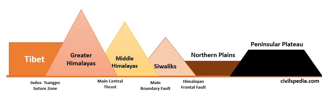
The Himalayan Frontal fault separates the Shivaliks from the Great Plains.
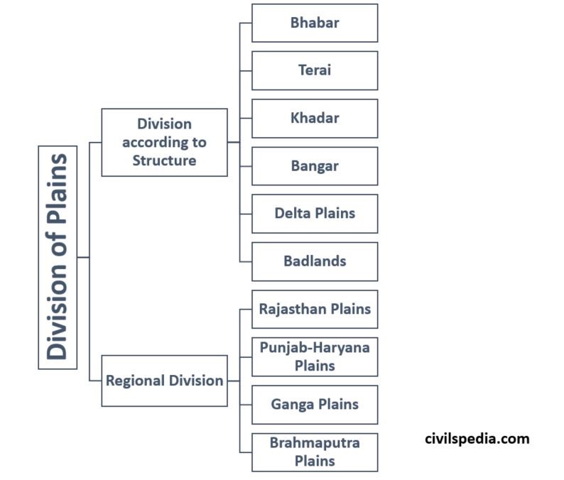
Divisions of Northern Plains
Northern Plains can
be divided in two ways as follows
1. Division based on Structure
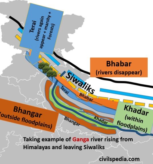
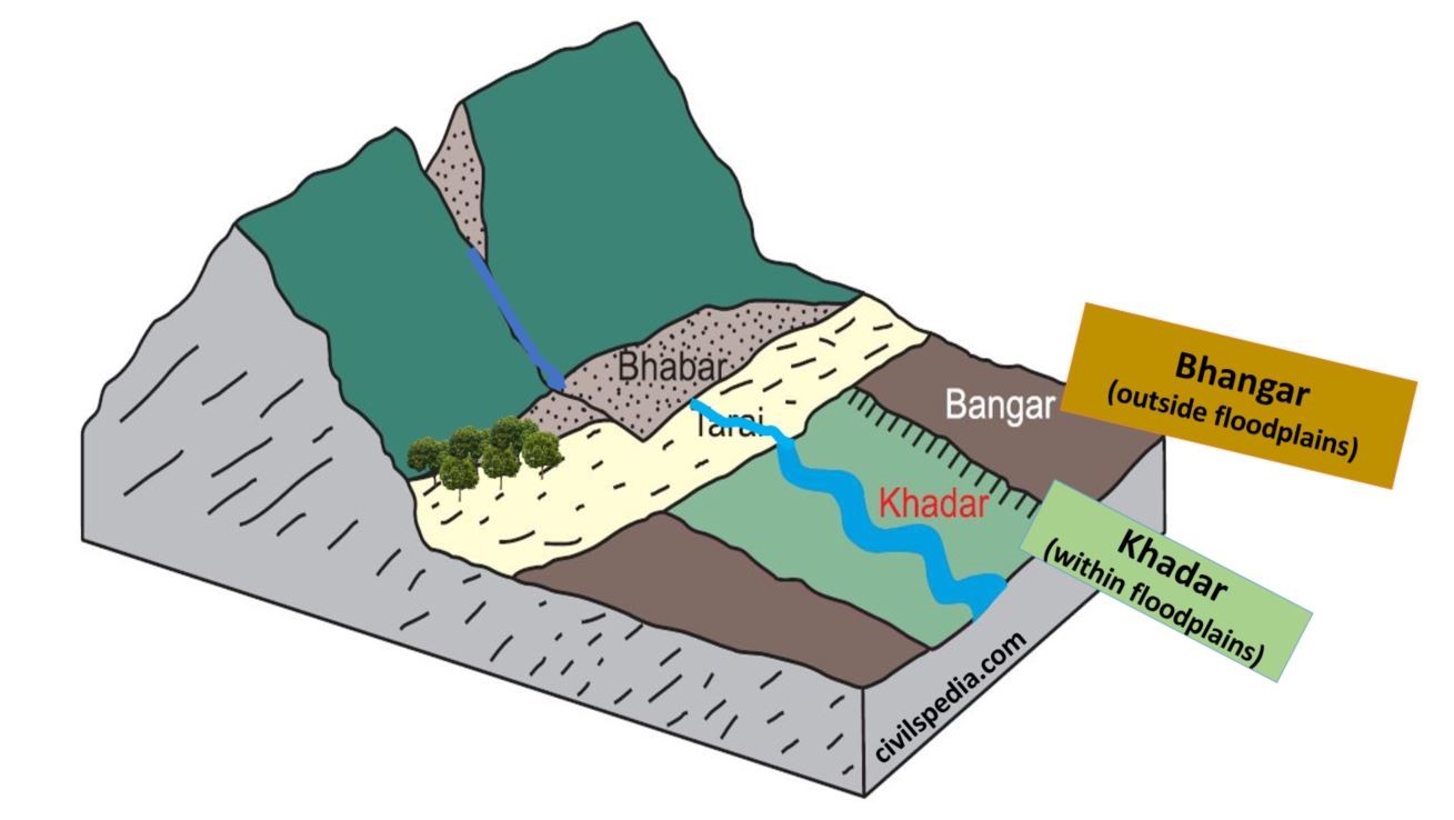
1.1 Bhabar Plain
Bhabar is a narrow belt of 8-10 km parallel to the Shivalik foothills at the break-up of the slope. It consists of pebbles & boulders made of debris washed down from higher ranges.
The permeability and porosity of the surface are so high that streams go underground & even disappear.
It is wider in the western plains (Jammu Division) than in the east (Assam).
Bhabar plain is unsuitable for cultivation. Only big trees with extensive roots can survive in this region.
1.2 Terai Plain
The Terai belt has an approximate width of 15 to 30 km and is located south of the Bhabar. Here, most streams and rivers re-emerge without having a well-delineated course, resulting in marshy and swampy conditions. (the word ‘terai’ is derived from the Hindi word ‘Tar’ meaning ‘wet’)
Terai plains are heavily forested, and house varied wildlife.
Because of deep roots, Terai soils have good nitrogen and high humus. Therefore, the colour of Terai soils is black (dark).
Most of the Terai land in states such as Punjab, Uttar Pradesh and Uttarakhand has been reclaimed and turned into agricultural land.
It is known for the excellent cultivation of sugarcane, rice and wheat.
Due to the varied wildlife, many National Parks and wildlife sanctuaries are also situated here (like Jim Corbett, Dudhwa, Manas, and Kaziranga National Parks).
1.3 Bhangar Plain
Bhangar plains are made of the older alluviums of the middle Pleistocene age, forming an alluvial terrace which lies above the flood limits of the rivers.
This soil is dark in colour, rich in humus content, well-drained and useful for agriculture.
There is a greater amount of lime-stone in the older alluvium known as Kankar, which decreases fertility.
Bhangar has the fossils of species which have got extinct in India. Examples include Asiatic Cheetah, Two-horned Rhino etc.
In Punjab, Haryana and Uttar Pradesh, these are called Reh, Kallar or Dhaya.
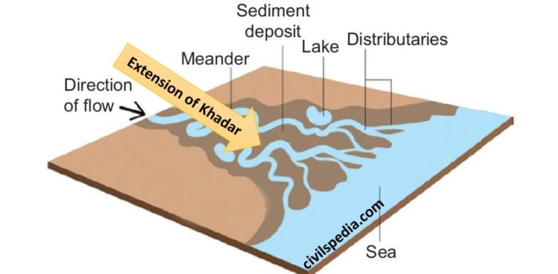
1.4 Khadar Plain
Khadar plains are the lowland areas within the flood limits of the river containing newer alluvium deposited by rivers flowing down plains.
They are enriched by fresh silt each year during the rainy season.
These soils consist of sand, silt, clay & mud and are highly fertile.
Fossils of existing species are found in Khadar.
In Punjab, they are known as ‘Bet‘ lands.
1.5 Deltas
Deltaic Plains are the extension of Khadar Plains.
Due to the sluggish river flow in this tract, it is an area of deposition.
The deltaic plain consists of old mud, new mud and marsh.
1.6 Badlands
In the north peninsular plateau and foothills of western Shivalik hills, due to gully erosion by the rivers, streams and rain, narrow valleys and ravines are formed, making land unfit for agriculture. Such plain areas are known as bad land.
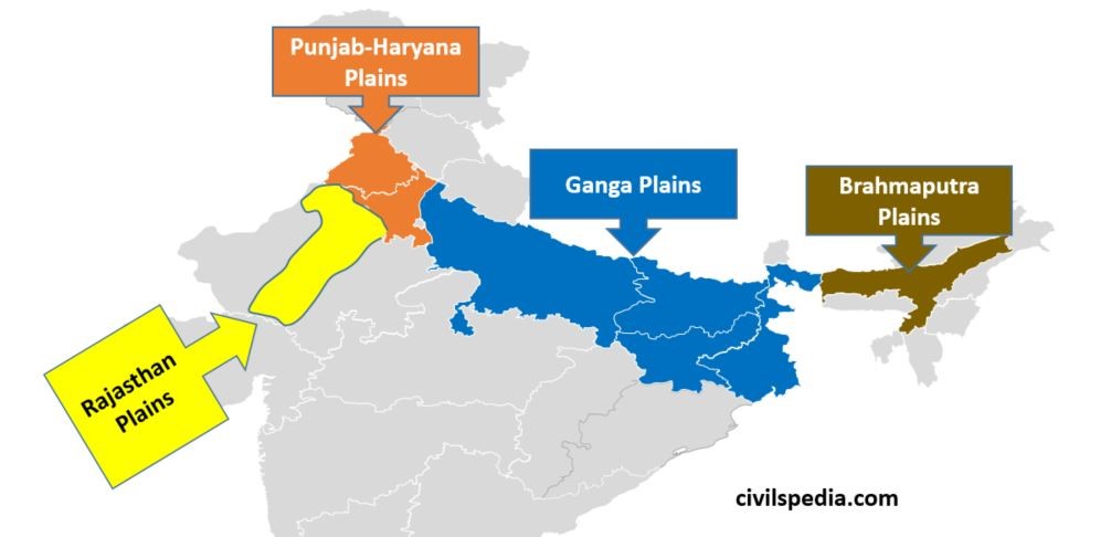
2. Regional Division
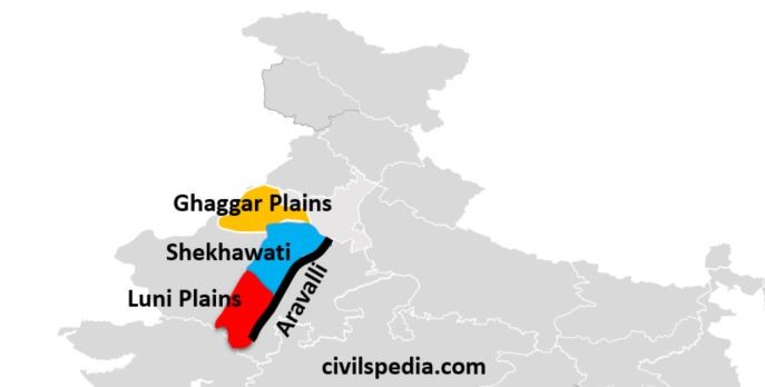
2.1 Rajasthan Plains
Rajasthan plain lies to the west of the Aravalli range and is divided into two parts, i.e. Marusthali and Bagar. Bagar region is part of the Northern plains while Marusthali is desert.
The Rajasthan plains slope toward the west and south.
Rajasthan Bagar is a semi-arid region as it receives very less rainfall
Rajasthan Bagar is further divided into three parts i.e.
Luni: Region drained by river Luni and its tributaries
Shekhawati Region: Region was ruled by Shekhawati Rajputs in the past.
Ghaggar Plain: River Ghaggar, an inland river, drains and terminates in this region. This region has benefited from Indira Gandhi Canal carrying Punjab’s water to Rajasthan.
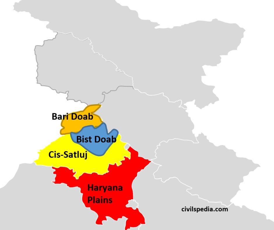
2.2 Punjab-Haryana Plains
These are fluvial plains of Ravi, Beas and Sutlej (tributaries of Indus). A large part of this plain is now in Pakistan.
The slope of this plain is towards the southwest.
Punjab Plains has numerous seasonal rivers originating from the Shivaliks during the rainy season known as Choes. These rivers are responsible for the ravine and gully erosion.
Delhi Ridge acts as the dividing line between the Indus River system (Punjab-Haryana Plains) and the Ganga River system.
It has the following divisions.
Bari Doab: Lie between Beas and Ravi rivers
Bist Doab: Area between Beas and Satluj rivers
Cis-Satluj / Malwa: Area of Punjab lying eastward of Malwa.
Plain of Haryana: Area between Ghaggar & Yamuna consisting mainly of present-day Haryana state. It has a ‘saucer-shaped topography’.
These plains are well irrigated but are now suffering problems due to over-irrigation leading to salination, over-use of fertilisers etc.
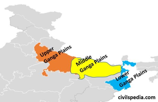
2.3 Gangetic Plains
Gangetic Plains extends from the Yamuna River to Bangladesh.
River Ganga and its tributariesconstitute this plain by their sediments and make a great plain in India.
It can be divided into three parts.
Upper Ganga Plains: Also known as Ganga-Yamuna Doab as it consists of the area between Yamuna in the west and Ganga in the east. Awadh and Rohilkhand plains also lie in them.
Middle Ganga Plains: Also known as the Bihar Plain or the Mithila Plain. It consists of the area between the Ghaghra River to Kosi River.
Lower Ganga Plains: It is a flat deltaic region lying between the gap in the Rajmahal and the Garo hill ranges. It is located in the state of West Bengal and Bangladesh. Duars of the Terai tract are found in its north, and the world’s largest Sundarbans Delta is located in its southern parts.
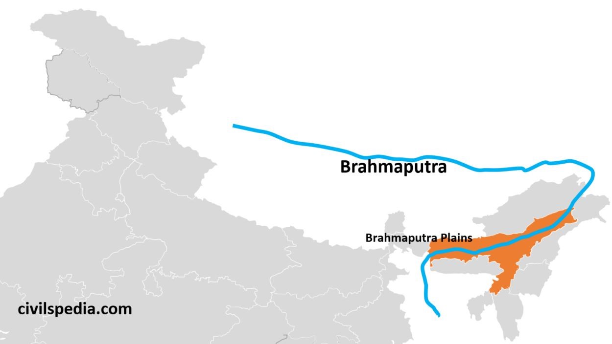
2.4 Brahmaputra Plains
Brahmaputra Plains is also known as Assam Plains or Assam Valley.
The Brahmaputra enters India as Dihang and debouches in the flat Assam region, where it is known as the Brahmaputra. On entering the Assam Valley, the speed of the river decreases, and it engages in a deposition which causes the river to shift its course and develop multiple channels. Such a river is called the ‘Braided River’. Brahmaputra River is highly braided and known for floods.
There are numerous riverine islands, out of which Majauli Island is the largest riverine island in the world.
Importance of Northern Plains
Granary of India
It is a region of very fertile plains. Therefore, it is the most important agricultural region.
Since it lies north of the Tropic of Cancer, Rabi and Kharif crops can be grown here.
Due to perennial rivers and underground water, canals and tubewell irrigation are well developed here.
Houses half of the Indian people
Northern Plains houses more than 50% of India’s population in one-fourth of the geographical area of India .’
Well developed Transportation
Due to flat topography and high population density, road and rail density is highest in the Northern plains.
Well-developed Food Processing Industry
Because of well-developed agriculture, the food processing industry dominates in this region.
Birthplace of Indian religions
All the main religious movements, from Vedic Hinduism to Buddhism, Jainism and Sikhism, were born in the Northern Plains. Hence, the Northern plains represent the soul of India.
This article deals with ‘The Coastal Plains(Geomorphology of India).’ This is part of our series on ‘Geography’, which is an important pillar of the GS-1 syllabus. For more articles, you canclick here.
Introduction
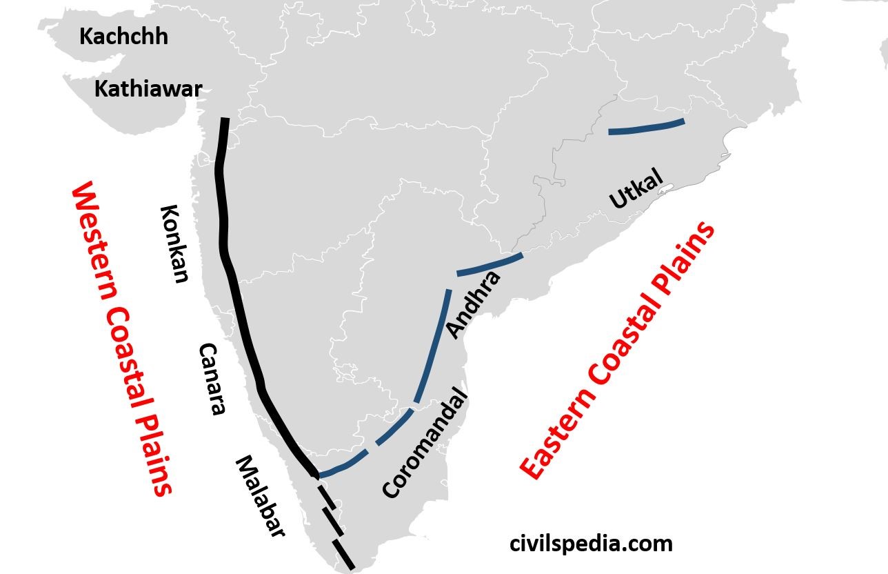
The narrow coastal strip between the edges of the Peninsular plateau and the coastline of India running for a distance of six thousand kilometres from the Rann of Kutch in the west to the Ganga-Brahmaputra delta in the east is called Coastal Plains.
Indian
Coastal Plains are of two types i.e.
West Coastal Plains
East Coastal Plains
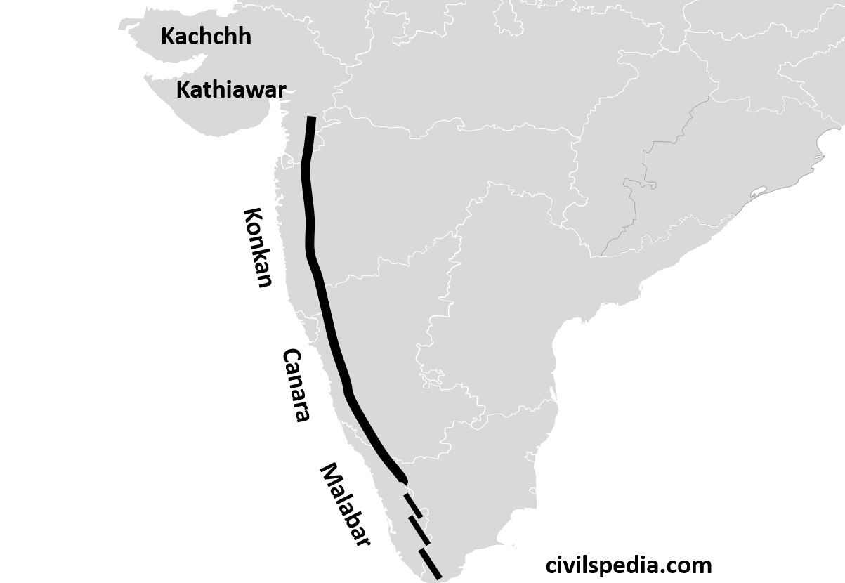
1. West Coastal Plains
It stretches from Rann of Kutch in the north to Kanyakumari in the south.
It is the coastline of Submergence except for the Kutch and Malabar regions.
These are very narrow (average width = 65 km). It is quite narrow in the middle and a bit broader in the north and south.
They receive very heavy rainfall, because of which laterite soil is found here. As a result, they are not very important for agriculture except for some plantation agriculture such as Cashewnut (Maharashtra and Karnataka), Coconut (Kerala), Tapioca and Rice.
They can be divided into the following parts
a. Kutch Peninsula
Kutch region is an emerged coast. It was an island surrounded by sea and lagoons. The sediments brought by the Indus River, which once flowed across this region, eventually filled these seas and lagoons.
It is an arid and semi-arid region receiving very less rainfall. The Arabian branch of the South-West monsoon passes by without causing any rain because of the absence of any obstruction to cause Orographic rainfall.
One of India’s busiest and most important ports, i.e. Kandla Port, lies in this region.
It is famous for salt mining.
The grassland in the Kutch region is known as Banni grasslands.
Kutch region is famous for Kharai camels which are swimming camels and facing threats due to salt mining and the destruction of mangroves.
The Kutch festival is celebrated every year, showing the unique landscape of white sands. Sands are white due to salt.
The most famous attraction is Mandvi Beach because of its white sand, purity of water and pearls.
b. Kathiawar Peninsula
It is a submerged coastline.
It is a region of black soil due to Deccan lava.
Due to black soil, it is famous for cultivating cotton, groundnut and tobacco.
Basaltic and volcanic mountains known as Gir Ranges are situated in this region. Gir ranges are also famous for Asiatic Lions.
c. Konkan Coast
It is a submerged coast extending from Daman to Goa, passing through Maharashtra.
India’s commercial capital lies in this region. Mumbai was an island, but parts of the sea lying between Mumbai and the mainland have been reclaimed in the recent past.
It is also rich in Petroleum resources. Bombay High lies here.
Famous west flowing river Mandovi or Mahadevi flows through the Konkan Coastal plains. Dudhsagar waterfall lies on the Mandovi River.
d. Canara Coast
It is a submerged coast lying in Karnataka.
It is famous for west flowing river Shravati. Jog Falls (271 m) lie on the Shravati River.
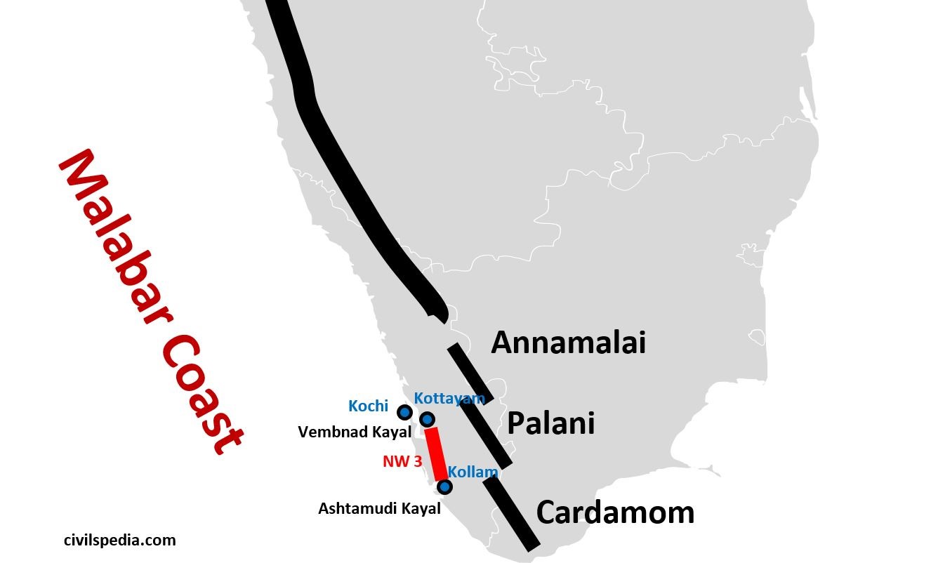
e. Malabar Coast
Malabar coast lies between Mangalore and Kanyakumari. It includes Southern Karnataka and Kerala.
It is a coastline of emergence and therefore has numerous lagoons and backwaters.
It is much wider as compared to the other parts of the western coast.
It is a low-lying plain with a height at no place exceeding 30 m above sea level.
Distinctive characteristics of the Malabar coast include lakes, lagoons, and “Kayals” (backwaters). Backwaters are shallow lagoons, and the largest among them is Vembanad Kayal or Vembanad Lake, which is 75 km long and 5-10 km wide. Kochi is situated on its opening.
Lake Vembanad is linked 4 other large lakes by canals and fed by 38 rivers to form National Waterway 3 from Kottayam to Kollam.
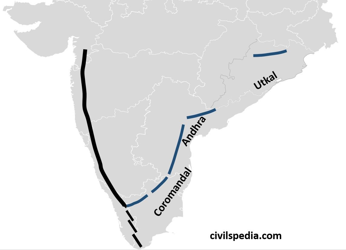
Eastern Coastal plains stretch from Subarnarekha river along West Bengal- Odisha border to Kanyakumari.
A major portion of the Eastern Coastal Plains has been formed by the depositional work of rivers Mahanadi, Godavari, Krishna and Kaveri, making some of the world’s largest deltas.
In contrast to the Western Ghats
They are wider, with an average width of 120 km.
They are coastlines of submergence.
They can be divided into the following parts
a. Utkal Plains
Utkal plains comprise coastal Odisha.
It includes the Mahanadi Delta with Cuttack at its head.
The most prominent physiographic feature of Utkal plains is Chilika Lake having the following features.
River Daya drains into the Chilika Lake (south of the Mahanadi delta).
It is the biggest lake in India.
It is famous for Olive Ridley Turtles, Salt Water Crocodiles and the largest number of migratory birds from Siberia, including Siberian Crane, Flamingos and White Bellied Eagles.
It is famous for an island known as Nalbana Island, which has Nalbana Bird Sanctuary.
Apart from that, Bhitarkanika is another important feature.
It is India’s second richest mangrove region located in the delta of the Baitarani, Brahmini and Mahanadi rivers.
The dense forests of Bhitarkanika have made it an important breeding ground for Olive Ridley Turtles and an important habitat for Indian saltwater crocodiles.
b. Andhra Plains
It extends from the south of the Utkal plains to Pulicat Lake (40 km north of Chennai).
It is drained by Godavari, Krishna and Penneru rivers.
Vishakhapatnam, the only natural port on the eastern coast, lies in Andhra coastal plains.
It is famous for Kolleru Lake and Pulicat Lake.
Kolleru Lake
– It is between the delta of Godavari and Krishna. – It was once a brackish water lake or lagoon. But due to the extension of the delta, it has now been converted into a freshwater lake.
Pulicat Lake
– It is the second-largest brackish water lake (or lagoon) in India. – It is shared by Andhra Pradesh and Tamil Nadu. – It is famous for an island in its mouth known as Sriharikota, the satellite launching centre of ISRO.
c. Coromandal Coast
It extends from Lake Pulicat to Kanyakumari along the Tamil Nadu coast.
It is drained by rivers Kaveri and Vaigai.
The Delta of the Kaveri River and large-scale irrigation facilities have made this region the granary of South India.
It is famous for rice cultivation.
Side Topic: Difference between Eastern & Western Coast
Western Coast
Eastern Coast
From Rann of Kutch
to Kanyakumari as a narrow strip of land between the Arabian Sea &
Western Ghats
From Kanyakumari to
Sundarbans, as relatively broader strip between Eastern Ghats & Bay of
Bengal
Highly influenced by South West monsoon.
Influenced by North
East monsoon, although it get monsoon from South West monsoon as well
Rivers form
estuaries
Deltas, long
beaches, salt marshes, lagoons etc., are
commonly formed
Example of Submergent coast
Example
of Emergent coast
Less
attacked by cyclones
More
attacked by cyclones
Why does the West Coast provide good ports than the East?
West Coast is Submergent Coast, whereas East Coast is Emergent Coast implying that Western Coast is deeper than Eastern Coast, providing favourable conditions for natural ports.
Western rivers form Estuaries, whereas Eastern rivers form Deltas, which require constant dredging to maintain the required depth necessary for the entry of ships.
Building excellent ports and harbours in the East is challenging since the continental shelf stretches 500 km into the ocean.
Due to the construction of the Suez Canal, the importance of the Western Coast increased as it provided a shorter route between India and Europe.
This article deals with ‘The Northern Mountains(Geomorphology of India).’ This is part of our series on ‘Geography’, which is an important pillar of the GS-1 syllabus. For more articles, you canclick here.
6 physiographic divisions of India
India
can be divided into 6 Physiographic features.
The Northern Mountains
The Great Northern Plains
The Peninsular plateau
The Indian Desert
The Coastal Plains
The Islands
The Northern Mountains
Himalayas extend ~2500 km in length, passing through 12 Indian states covering 17% of the Indian geographical area & consist of many valleys between them.
These mountains consist of the youngest and the loftiest mountain chains in the world because they were formed only a few million years ago due to the collision of the Indo-Australian and Eurasian plates.
The region is vast, rugged & versatile, supporting remarkable cultural, ethnic & biological diversity.
Formation of Himalayas
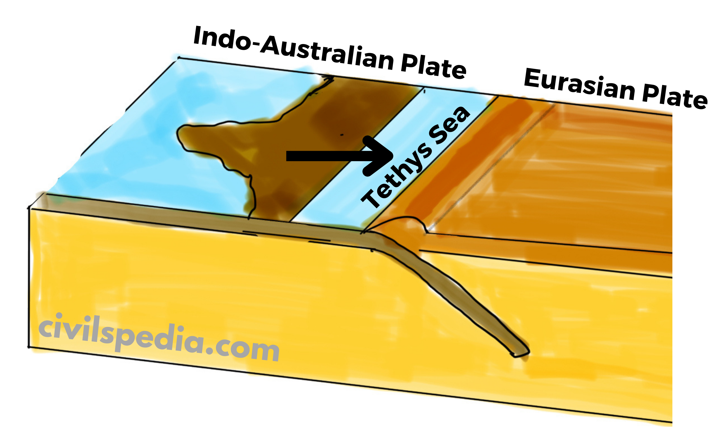
The Himalayas were formed due to the convergence of tectonic plates, i.e. Indo-Australian plate in the south and the Eurasian plate in the north.
The place where the Himalayas are situated today was occupied by the Tethys Sea. On its sea bed, sediments were deposited, brought by the then rivers from the Tibetan plateau in the north and Gondwana land (Deccan Plateau) in the south.
About 70 million years ago, the Indo-Australian plate separated from Gondwanaland and started to move towards the Eurasian plate at a speed of 12cm/year. As a result, Tethys Sea began to contract.
Since the Indian plate was made up of denser material than the Eurasian plate, the Indian plate started to subduct under the Eurasian plate causing the lateral compression and folding of sediments accumulated in the Tethys Sea. The Himalayas are thought to have formed as a result of the compression of sediments from the Tethys Sea over three distinct stages.
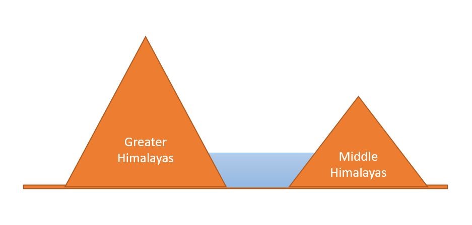
First Phase: Started about 50 million years ago and completed 30 million years ago with the formation of the Great Himalayas.
Second Phase: Took place between 30 to 25 million years ago, resulting in the formation of the Middle Himalayas.
Third Phase: Took place between 20 to 2 million years ago, resulting in the formation of Shivaliks.
The Indo-Australian plate is still moving northwards at 5 cm/year, and the Himalayas are still rising.
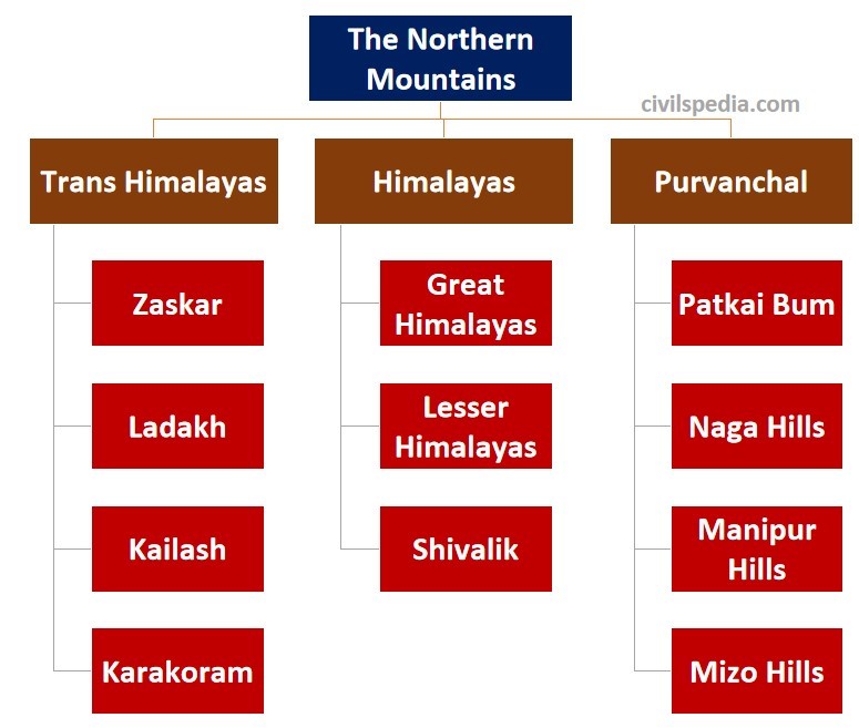
Divisions of Northern Mountains
The collision of the Indo-Australian plate with the Eurasian plate was not smooth. This collision led to the formation of a number of ranges. These ranges include Trans-Himalayas, Himalayas and Purvanchal. The Himalayas and other high peaks are joined by the Pamir Knot, also referred to as the “Roof of the Earth.”
In India, the Northern Mountains are grouped into three divisions. 1) The Trans-Himalayas, 2) the Himalayas, 3) the Eastern or Purvanchal Hills.
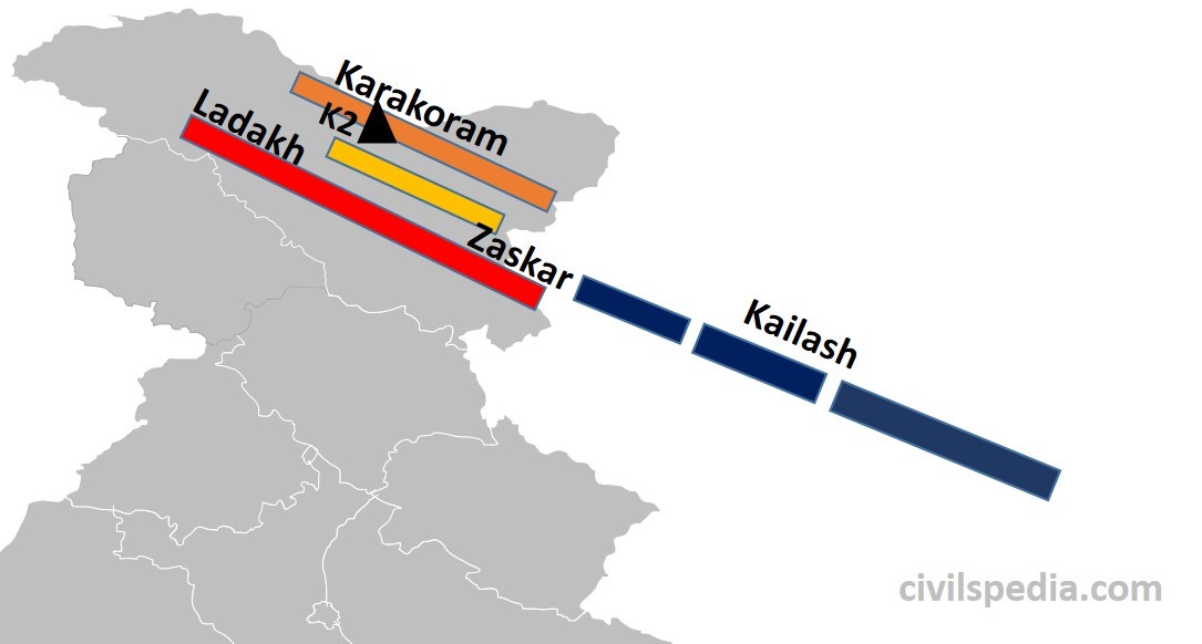
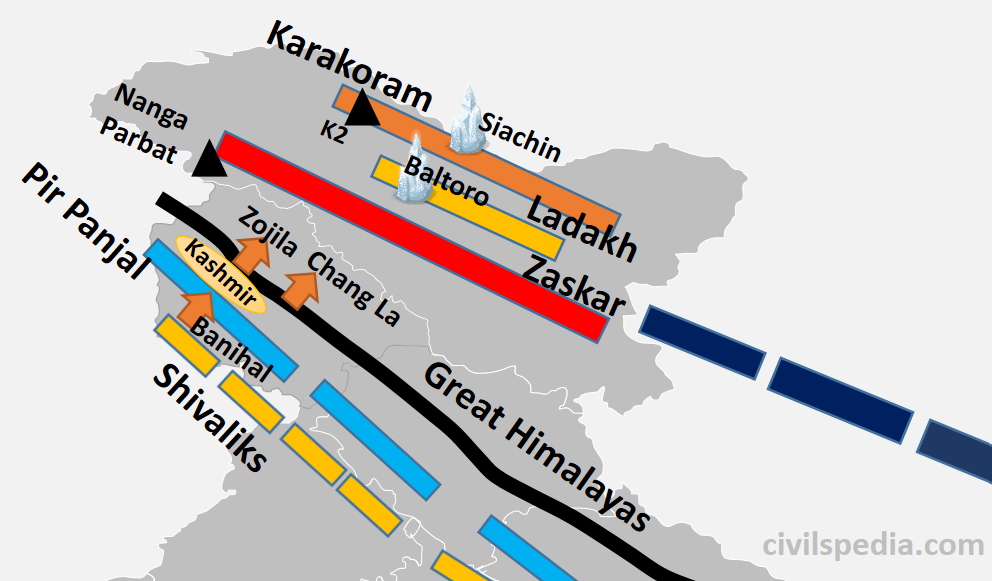
1.1 Trans Himalayas
It lies north of the great Himalayan range in Kashmir, Ladakh, and the Tibetan plateau.
They are of volcanic origin as they were formed by the volcanic eruption due to the initial interactions between the oceanic part of the Indo-Australian and Eurasian plates.
They also contain the Tethys sediments.
The prominent ranges of the Trans Himalayas are Karakoram, Ladakh, Zaskar and Kailash.
It has some of the highest peaks in the world, like K2 (the highest mountain peak in India and the second-highest peak in the world).
To the north of trans-Himalayas lies the heavily dissected, eroded, flat region known as the Tibet plateau. This region has numerous saline lakes like Salt Lake, Pangong Tso, Tso Moriri etc.
Karakoram-Ladakh region has India’s largest notified protected area (i.e. national park) known as Hemis National Park. It has the highest density of Snow Leopards in the world.
1.2 The Himalayas
The Himalayas are the core part of the northern mountains.
The Himalayas extend from the Indus Gorge in the west to Namcha Barwa (or Dihang Valley or Brahmaputra Gorge) in the east (~2500 km).
These are young fold mountains formed very recently in Earth’s geological history.
The shape of the Himalayas is like a convex curve towards our country, whose middle portion is sagged inwards India. Its reason lies in the process of its formation. When Indo-Australian Plate collided with Eurasian Plate, Aravalli and Shillong Plateaus were situated at the western and eastern edge of the colliding region where the Himalayas were formed. Hence, the western and eastern edge was strong, but the middle part was plain & therefore weak, which got sagged, resulting in the convex shape of the Himalayas.
The slope of these mountain ranges in the south towards India is very steep, whereas it has a gentle slope towards China in the north (due to the presence of the high Tibetan Plateau). That is why it is difficult to cross the Himalayas from the south.
Many Antecedent rivers reach plains after passing through the Himalayan mountains. Antecedent rivers are those that were present before the formation of the Himalayas, and their water source is beyond the Himalayas. Although their path was blocked due to the formation of the Himalayas, they gradually made their way after eroding the Himalayas. These include Indus, Sutlej, Brahmaputra etc.
The main divisions of the Himalayas are
Greater Himalayas
Lesser Himalayas
Shivaliks
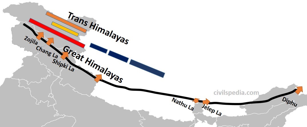
1.2.1 The Greater Himalayas
These are also known as Internal Himalaya or Himadri.
They are about 25 km wide.
The average height in this range is 6100 meters. Mount Everest (8,848 m), the highest peak in the world, is also situated in this range along with other high peaks like Kanchenjunga, Makalu, Dhaulagiri etc.
Due to their great heights, the peaks of almost all mountains remain snow-covered throughout the year. Since it is a region with permanent snow cover, it has many glaciers like Gangotri, Yamnotri, and Siachin.
It is the longest and most continuous sub-division of the Himalayas. Its length is 2400 km and extends from Nanga Parbat (or Indus Gorge) in north–west to Namcha Barwa (or Dihang Valley or Brahmaputra Gorge) in the east.
It contains sedimentary rocks (due to the folding of sediments of the Tethys Sea) as well as Metamorphic rocks (due to pressure created by the collision of two plates).
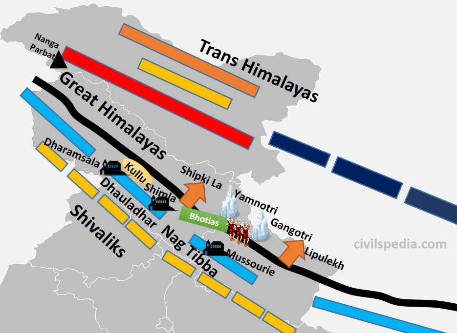
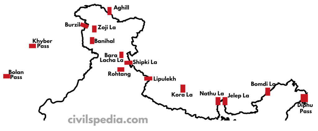
It contains many passes. Although, it is very difficult and dangerous to cross this mountainous subdivision. But still, many passes are found to cross this, like Burzil and Zojila in Kashmir, Chang La in Ladakh, Shipki La in Himachal Pradesh, Lipulekh in Uttarakhand, Nathula and Jelep La in Sikkim and Diphu pass in Arunachal Pradesh.
The Greater Himalayas receive less rainfall than the Lesser Himalayas and the Shivaliks.
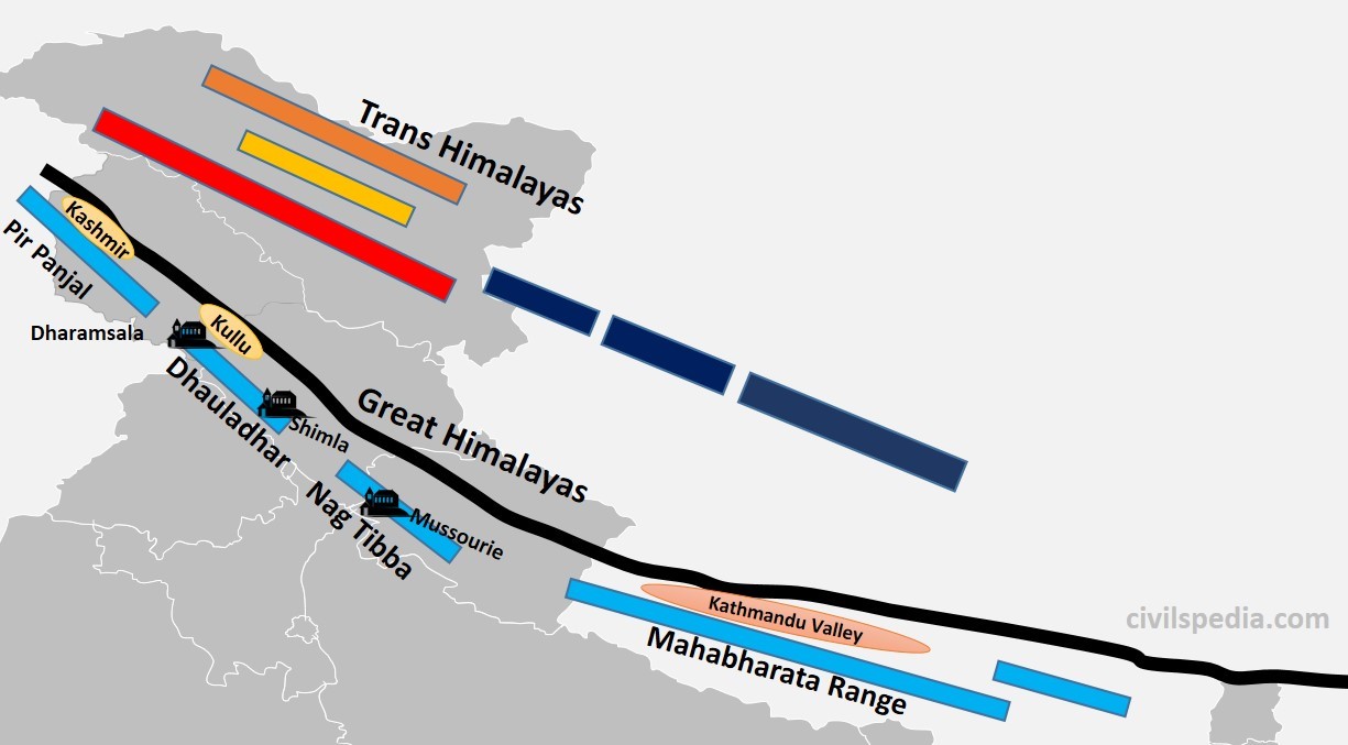
1.2.2 The Lesser Himalayas
They are also known as Himachal or Middle Himalayas.
The height of this range varies from 3,700 to 4,500 m.
Its width varies up to 80 km. (hence, it is lower in height but wider than Greater Himalayas)
Slate, limestone & quartzite are the major rocks found in this range.
This region is subjected to extensive erosion due to heavy rainfall, deforestation and urbanization.
It also contains famous hill stations of the Himalayas like Shimla, Mussourie, Nainital, Almora, Ranikhet and Darjeeling.
Lesser Himalayas are not a continuous range (unlike Greater Himalayas) and is divided into
Pirpanjal (J&K)
Dhauladhar (Himachal Pradesh)
Nag Tibba (Uttarakhand)- Mussourie & Kumaon ranges are part of Nag Tibba
Mahabharata Range (Nepal)
The region between Greater Himalayas and Lesser Himalayas contains many valleys like Kashmir Valley, Kangra Valley, Kullu Valley, Bhagirathi Valley and Mandakini Valley.
Many passes are also present, which provide passage through Lesser Himalayas to reach these valleys like Banihal and Qazigund, connecting Jammu with Kashmir.
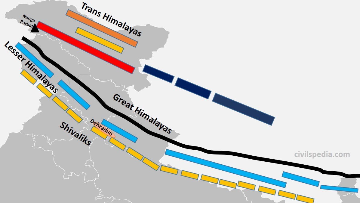
1.2.3 The Shivaliks
Also known as Outer Himalayas and Southern Himalayas
Siwaliks extend from Jammu and Kashmir to Assam.
Their average height varies between 900 to 1200 metres. Hence, they are the lowest among all Himalayas.
It is mainly made by the debris brought by the Himalayan rivers as they were geologically formed during the Tertiary period by the upliftment of the foothills of the Himalayas, where rivers have settled their sediments.
It is the most discontinuous range.
Longitudinal valleys are found between the Shivaliks and the Lesser Himalayas, which are called Duns. The most famous among these are Dehradun, Patlidun, Udhampur etc.
They are known by various names like
Jammu Hills (in J&K)
Dhang and Dundwa (in Uttaranchal)
Churia Ghat Hills (in Nepal)
Dafla, Miri, Abhor and Mishmi (in Arunachal)
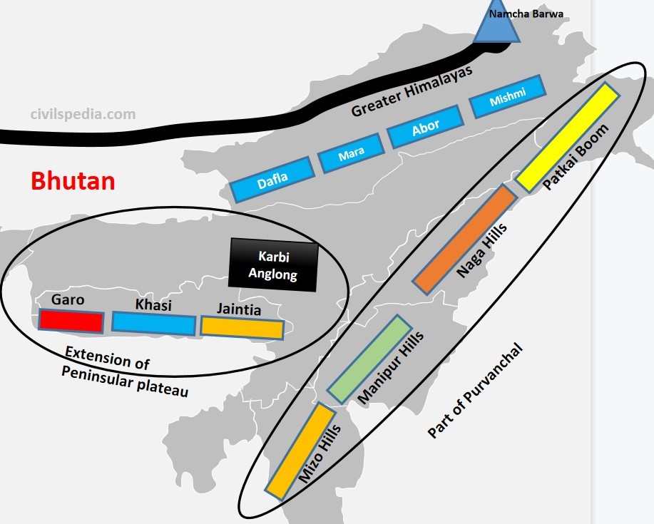
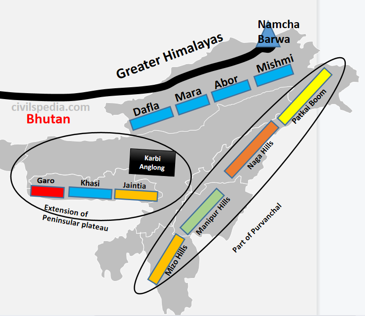
1.3 Purvanchal
After
crossing Dihang Gorge, the Himalayas bends southward (syntaxial bend), forming
a series of hills. They have the same progeny as that of the Himalayas &
are part of the Northern mountain system. They are aligned north to south and
are known by different local names.
Patkai Bum
Forms border between India and Myanmar
Naga Hills
Situated in Nagaland and forms the border between India and Myanmar
Manipur Hills
The physiography of Manipur is unique, represented by the presence of ‘Loktak’ lake in the centre and surrounded by mountains called Manipur Hills from all sides.
Mizo Hills
– They are also known as the Lusai Hills. – Mizoram is also known as the ‘Molasses Basin’as it is made up of soft unconsolidated deposits brought by small rivers originating in these hills.
Arakan Yoma
Purvanchal extends in Myanmar as Arakan Yoma, which further continues southwards as Andaman and Nicobar Islands.
Above ranges in the Purvanchal are separated from each other by numerous small rivers.
Note:
Garo, Khasi, and Jaintia hills of the Meghalaya plateau are not a part of
Purvanchal or the Himalayas in general. They are an extension of the Peninsular
Plateau.
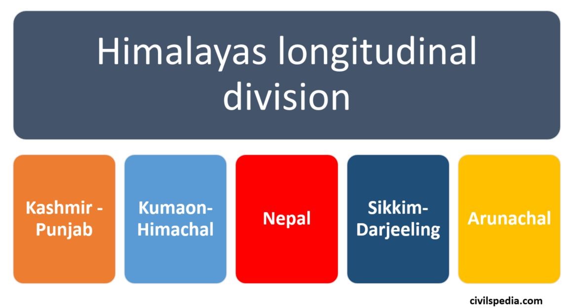
2. Longitudinal Divisions of Himalayas
There
is another way to divide the Himalayas longitudinally into Kashmir-Punjab
Himalayas, Kumaon Himalayas, Nepal Himalayas, Sikkim-Darjeeling Himalayas and
Assam Himalayas.
2.1 Kashmir-Punjab Himalayas
Major Characteristic of the Kashmir Himalayas is deep valleys, and high mountain passes like Zoji la, Bara Lacha La, Banihal and Qazigund.
Between Great Himalayas and the Pir Panjal range lies the world-famous valley of Kashmir
The Baltoro and Siachen glaciers, two significant glaciers in South Asia, can also be found here.
Kashmir Himalayas are famous for its Karewa formations, known for cultivating Zafran, a local variety of saffron.
Some of the important freshwater lakes like Dal & Wular and saltwater lakes like Pangong Tso & Tso Moriri are also in this region. ( Note: Dal Lake is Oxbow Lake).
Srinagar is located on the banks of the Jhelum River, and Dal Lake, situated in Srinagar, presents an interesting geographical feature. Jhelum River in Kashmir valley is still in its youth stage but forms a meander – a feature associated with the mature stage of rivers.
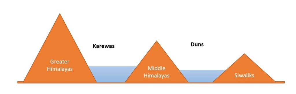
Side Topic: Karewas Formation
During the Quaternary period, when Pir Panjal Mountains were formed, the Kashmir valley, surrounded by Great Himalayan Range in the north & Pir Panjal Range in the south, was submerged under water, and a big lake of about 5000 sq km area was formed. All the sediments that rivers brought to this giant lake kept settling downwards.
Later, because of endogenic forces, Baramullah Gorge was created, and this vast lake was drained through the gorge leaving behind sediments. These deposits are called Karewas. Hence, Karewas are fluvio-lacustrine Plains
Examples of lacustrine plains include.
The Kashmir Valley of India.
The Imphal Basin in the Manipur hills
The watershed of the Red River in the USA and Canada
The Karewas are well suited for the cultivation of saffron, walnut, almond, and orchards.
Jhelum is still in its Youthful stage in Kashmir, but it forms Meanders, characteristic of the Mature Stage. Why?
Meanders are formed when moving water erodes the outer banks, whereas the inner part of the river, having less intensity, deposits silt and sediments, which results in a snake-like pattern of the water stream.
The main requirement for the Meander formation is the need for silt and sediments and the slow speed of river waters.
In Kashmir valley, these sediments are provided by local base levels of formerly existing Karewas.
It is the reason Jhelum meanders. Along with that, the formation of Wular Lake, which is an Oxbow lake, is also explained by this phenomenon.
Shivalik (locally called Dhang and Dundwa Range in Uttaranchal)
In Lesser/Middle Himalayas section of the Kumaon-Himachal Himalayas, the altitude between 1,000-2,000 m attracted the British colonial administration due to its moderate climate (resembling the British weather). Subsequently, important hill stations such as Dharamshala, Mussorie, Shimla, Kaosani etc., were developed in this region.
Dun formation is an important feature of this part. The largest of all the duns, Dehra Dun measures roughly 35–45 km in length and 22–25 km in width.
This section, too, has passes like Shipki La and Lipulekh pass. Lipulekh is used as a pathway to reach Kailash Mansarovar in Tibet.
In the Great Himalayan section of the Kumaon-Himachal Himalayas, the valleys are inhabited mainly by the Bhotias. The Bhotias is a nomadic tribe that moves to the higher ranges’ called “Bugyals” (summer grasslands) in the summer and return to the valleys in the winter.
Kumaon-Himachal Himalayas has many glaciers like Nandadevi, Badrinath, Kedarnath, Gangotri and Yamnotri, a source of rivers like Yamuna and Ganga. Many pilgrimages, such as the Gangotri, Yamnotri, Badrinath, Kedarnath and Hemkund Sahib, are also situated here.
Side Topic: Duns formation
Duns are the same as Karewas, i.e. they too are fluvio-lacustrine plains formed with sediments left behind by a former lake, with the only difference being that they are formed between Middle Himalayas and Siwaliks.
When Shivalik was formed, drainage of the region was impounded & the whole area was submerged in water between Shivalik & Middle Himalayas, creating a huge lake. The river gradually finds weak rocks to cut across mountains & flows through it. Lake dries up & duns are formed by the sediments left by the former lake.
E.g. Dehradun between Siwaliks and Mussoorie range, Jammu Dun between Pir Panjal and Shivaliks, Pathankot Dun between Siwaliks and Dhauladhar, Chandigarh-Kalka dun etc.
Some of the water remained in the depressions forming lakes known as Taals. Examples include Nainital, Bhimtal etc.
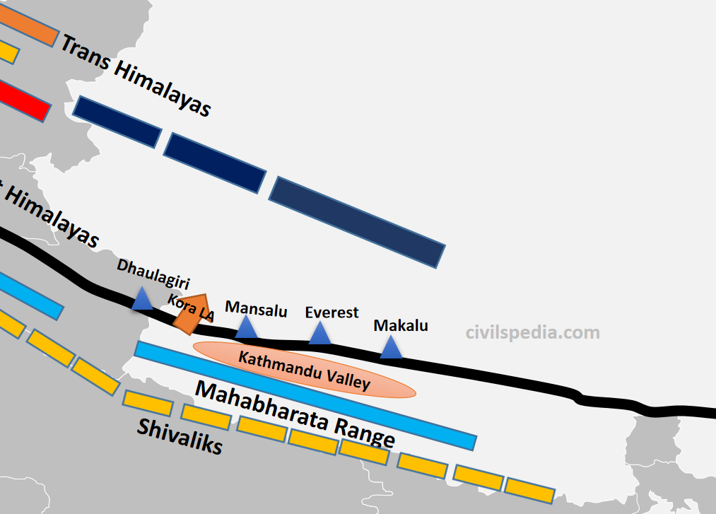
2.3 Nepal Himalayas
It is the tallest section of the Himalayas.
Mountain sections in it include
Great Himalayas containing peaks like Dhaulagiri, Annapurna, Mansalu, Everest, Makalu etc
Middle Himalayas: Mahabharata range
Shivaliks (locally called Churia Ghat Hills)
The famous and densely populated Kathmandu Valley is situated between Great Himalayas and Middle Himalayas.
Passes like Kora La connects Kathmandu valley with Tibet (will be used by China to build railways and roads and was in the news).
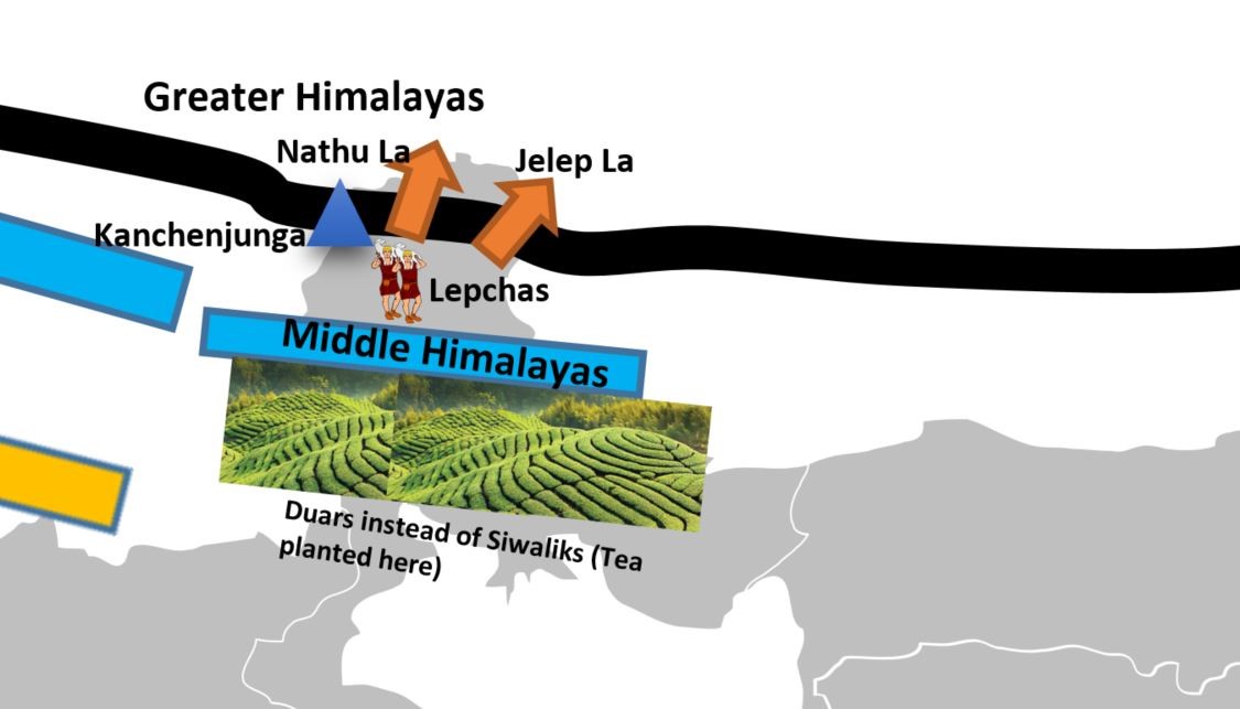
2.4 Sikkim/Darjeeling Himalayas
Sikkim Himalayas lies between Kosi & Teesta Rivers.
It is an area with deep valleys and lofty mountain peaks like Kanchenjunga (Kanchengiri).
Lepcha tribes inhabit the higher reaches of this region, while the southern part (Darjeeling) has a mixed population consisting of Bengalis, Nepalis and tribals from Central India.
The British established tea plantations in this area by taking advantage of the favourable physical circumstances, which included a moderate slope, thick soil cover with high organic content, evenly distributed rainfall throughout the year, and mild winters. They, together with the Arunachal Himalayas, stand out from the other Himalayan ranges due to the absence of the Shivalik formations. Here, the “duar formations” are significant—which have also been exploited to create tea gardens.
Sikkim & Darjeeling Himalayas are known for their scenic beauty & rich flora & fauna, particularly various orchids.
Sikkim Himalayas has passes like Jelep la ( forming a tri-junction of India-China-Bhutan) and Nathula.
Side Topic: Duars
Duars are floodplains on the foothills of the Himalayas in Assam and the northern part of West Bengal (Darjeeling).
They are made up of loose sediments brought down by Himalayan rivers and deposited each season. The streams often than not shift course and spread the load over broad tracts. Some streams disappear underground and re-emerge only later. It makes duars very damp regions.
Duars are not the peneplains (uniform and almost levelled plain). They may have considerable height. The altitude of this region varies widely, with as low as 90 m and as high as 1,750 m.
The British introduced tea plantations in this region due to the following physical conditions.
Moderate slope.
well-distributed rainfall throughout the year
Thick soil with high organic content
Mild winters (tea can’t withstand frost & snow)
2.5 Arunachal Himalayas
Arunachal Himalayas spans between Bhutan Himalayas (in the east) to the Namcha Barwa (in the west).
They have the following sections
Greater Himalayas
Middle Himalayas are absent
Shivaliks are known by the names Dafla, Miri, Abor and Mishmi.
Important mountain peaks of the Arunachal Himalayas include Kangtu & Namcha Barwa.
Rapidly moving rivers cut deep gorges in these mountain ranges. The Brahmaputra cuts a deep gorge after crossing Namcha Barwa called Dihang or Brahmaputra gorge. The Kameng, Subansiri, Dihang, Dibang, and Lohit are the other significant rivers of this region. They have huge hydroelectric power potential since they are perennial and have a high rate of fall.
Arunachal Himalayas are inhabited by numerous ethnic tribal communities. Some of the prominent ones are the Abor, Mishmi, Nyishi and Nagas. Primarily, they practise Jhumming agriculture.
Side Note: Important Passes in the Himalayas
As previously discussed, the Himalayas and associated mountains have many passes. These types of questions can be asked in the exam. Hence we are going to provide a list in concentrated form
Aghill pass
Ladakh
Connects
Ladakh with Xinjiang province.
Burzil Pas
Ladakh
Connecting link between India and Afghanistan and other Central Asian countries.
Zoji La
J&K and Ladakh
Connects Kashmir valley with Ladakh.
Bara Lacha La
Himachal
Connects Manali in Himachal Pradesh to Ladakh.
Shipki La
Himachal
River Satluj enters
India through it and it is the sole trade route between India and Tibet
Lipulekh
Uttarakhand
– It is at the trijunction of India (Uttaranchal), Nepal and China. – Kailash Mansarovar Yatra use this pass – It was in the news due to the Kalapani dispute with Nepal because Lipulekh sits at the top of Kalapani.
Jelep La
Sikkim
Tri
Junction of India, Bhutan and China
Nathu La
Sikkim
Important trade route between India and China
Bomdi La
Arunachal
Connects Arunachal with Lhasa.
Diphu Pass
Arunachal
Tri Junction of India, Myanmar and China
Khyber Pass
Pakistan
Connects Pakistan and Afghanistan (but important because in history, invaders used this to invade India, and traders used this for trade with Central Asia)
Bolan Pass
Pakistan
In Pakistan (has the same history as that of Khyber Pass)
Kora La
Nepal
Connects
Nepal and Tibet
Banihal & Qazigund
J&K
Connects Jammu to Kashmir & contains Jawahar Tunnel
Rohtang Pass
Himachal
Side Topic: Important Glaciers
Siachin Glacier
UT of Ladakh
In the Karakoram Ranges. It is the longest glacier outside the polar regions.
Baltoro
UT of Ladakh
Situated in the
Ladakh ranges
Gangotri Glacier
Uttarakhand
Source of Ganga river
Yamnotri Glacier
Uttarakhand
Source of Yamuna river
Pindar Glacier
Uttarakhand
Source of Pindar river
Zemu Glacier
Sikkim
Source of Teesta river
Importance of Himalayas
Climatic Importance
The Himalayas protect us from the extremely cold winds coming from the north.
The Himalayas also forces southwest monsoon winds to shed whole moisture in India.
Due to the obstruction of the Himalayas, the Westerly Jetstream shed rainfall and snowfall in winters, known as Western Disturbances.
Rivers
The Himalayas are the source of perennial rivers which has deposited large amount of alluvium, forming the Great Plains of India.
Various major rivers of India originate from the Himalayas. These rivers are a source of irrigation for a significant portion of agriculture in India.
They are the source of Hydroelectric power.
Biodiversity
Himalayas go through different bio-geographic and climatic zones. There is a succession of vegetation from topical to tundra. Hence, biodiversity is very high in the Himalayas with large endemism.
Many animals, including tigers, snow leopards, elephants, rhinoceros, etc., are found in the Himalayas.
A large number of herbs of medicinal value are also found in the Himalayas.
Tourism and Religious Importance
Tourists from all over the world visit the hill stations situated in the Himalayas. E.g. McLeod Ganj, Shimla, Nainital Mandi, Mussoorie, Darjeeling etc.
Various religious places are also part of the Himalayas, e.g. Kailash, Amarnath, Kedarnath, Vaishno Devi, Jawala Ji, Chintpurni, Gangotri, Yamnotri, Hemkund Sahib etc.
Mineral Resources
The Himalayas are rich in metallic minerals such as copper, lead, zinc and gold.
The Himalayan rock salt is used in traditional medicines and aromatherapy.
The Siwaliks are a very good source of limestone.
Coal is found in Jammu & Kashmir (Kalakot) and Arunachal Pradesh (Namchik-Namphuk)
Petroleum in India was first discovered in the Himalayas in the upper Assam region.
Factors responsible for the Location of Industries
This article deals with the Factors responsible for the Location of Industries.’ This is part of our series on ‘Geography’, which is an important pillar of the GS-1 syllabus. For more articles, you canclick here.
Introduction
The industrial sector refers to the part of the economy involved in producing goods through machinery, technology, and mass production methods.
Classification of Industries
Primary Industry
They use natural raw material
E.g., Agriculture, fishing, forestry etc.
Secondary Industry
Use material obtained from primary industries to produce complex products
E.g. Fibre to readymade garments
Tertiary Industry
It provides services (not related to manufacturing)
E.g. transport, consultancy, tourism, health services etc.
Factors responsible for the Location of Industries
Where
Industry can set up
1. Nature of Raw Material
Industries
using raw materials that lose weight are concentrated in the regions where raw
materials are found.
Sugar Industry: Conversion of sugarcane to raw sugar involves a lot of weight loss. Hence, the sugar industry is set up near raw materials.
Steel Industry: Both Iron ore and coal are weight-losing. Therefore, a suitable location for the iron & steel industry is near raw material sources.
2. Market
Markets serve as outlets for manufactured goods.
Heavy machines, machine tools, and heavy chemicals are located near the high-demand areas as these are market-oriented.
Similarly, Petroleum refineries are also located near the markets as crude oil can be transported easily compared to several products derived from it. Koyali, Barauni and Mathura refineries are typical examples.
3. Historical Factors
Mumbai, Calcutta & Madras are industrially developed due to various historical factors such as the presence of capital and its proximity to power during British times as they were Presidency towns.
The availability of coal in the region and the presence of navigable waterways provided the necessary resources and transportation routes for the growth of the textile industry in cities like Manchester and Liverpool.
The automobile industry developed in Detroit, Michigan, due to its proximity to raw materials like iron and coal and the Great Lakes waterway, which facilitated transportation. The establishment of the Ford Motor Company in Detroit in 1903 further solidified the city’s position as a hub for automobile manufacturing.
Once a particular industry develops in a certain area, the forward & backward linkages of the Industry in these areas become well-developed. It attracts new Industries to these cities.
4. Government policies
Government
policies become a major factor in deciding where the industry will be set up.
For example,
If a government offers tax breaks or other financial incentives to companies that locate in certain regions, those companies may be more likely to choose those locations. In India, tax breaks were provided to industries located in hilly areas like Himachal, and as a result, large industries from the Punjab-Himachal border shifted to Himachal.
Similarly, companies may be less likely to locate if a government imposes strict environmental regulations in certain areas.
5. Transport
The
industry is set up in an area where infrastructure is developed & area is
easily accessible.
Switzerland makes wristwatches & not bulldozers because of transport reasons.
The Great Lakes area (in North America) is highly industrialised because it is well connected via rail, road and ships.
6. Labour
Highly
skilled labour is required to run Industry. Due to this reason
African countries export rough diamonds because they don’t have skilled labour to finish them
Australia supplies raw wool & not woollen garments because there aren’t enough people.
7. Availability of Capital
The
term “capital” refers to the funds or financial resources
needed to start and operate an industry. It is an important factor in deciding
the location of an industry, illustrated by the following examples.
The industry is located in Mumbai and Chennai because the capital is easily available there.
Software companies, including Apple, Google, Facebook etc., are concentrated in California as many venture capital firms are present to fund startups.
8. Climate
Climate
can be an essential factor in deciding the location of industries, as certain
industries require specific environmental conditions to operate effectively,
Tech companies are located in San Francisco (Silicon Valley), and Bangalore (Silicon Valley of India) because of the mild climate in the region, which provides a comfortable environment for workers, and the lack of extreme heat or cold can prevent equipment malfunctions.
The Winter Sports equipment industry is located in Helsinki (Finland) because cold weather provides a natural testing environment for products, and snow and ice create demand for such products.
9. Electricity
Electricity is a major determinant as it powers the industry and is needed in many industrial processes.
E.g., in Aluminium Industry, massive electricity is required for Bauxite refining. Hence, Aluminium Industry will be set up where electricity is cheap.
With the increase in science and technology, geographical factors are becoming less relevant in deciding the industrial location.
Climate control is made possible for industrial purposes. For example, artificial humidifiers are used for climate control in dry areas.
Electricity as a source of energy is easily transmitted over a long distance; similarly, pipelines and improved transportation have increased the availability of petroleum fuel as a source of energy even at distant locations.
Rails and roads can now reach anywhere, breaching even the Himalayas and other mountains. E.g., China is building Industry in Xinjiang province, which was impossible earlier.
This article deals with ‘Monsoon Theories.’ This is part of our series on ‘Geography’, which is an important pillar of the GS-1 syllabus. For more articles, you canclick here.
Introduction
The Monsoon is traditionally defined as the seasonal reversal of winds and related changes in precipitation. Monsoon is a surface wind that blows in a particular direction in one season but reverses completely in the other season.
Monsoon is the main characteristic of the Indian Climate and requires special study. Hence, we will study that in detail.
Monsoon Theories
Monsoons are a complex meteorological phenomenon. Meteorologists have proposed numerous theories explaining the origin of monsoons.
1. Halley’s Thermal Theory
Mechanism of summer Monsoon
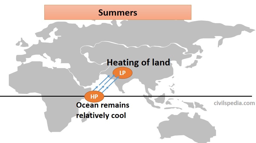
During summer, interior parts of the North Indian Plains covering Rajasthan, Punjab, Haryana etc., are heated strongly. As a result, low pressure develops, resulting in the formation of the monsoonal trough.
Temperature over the Indian Ocean is still low. Hence, high pressure prevails over the Indian Ocean.
Hence, the general movement of air in JUNE is from the South-West (Indian ocean) to North-East (Indian Subcontinent) (this direction is directly opposite to trade winds prevailing during Winter).
When these moist winds from the Indian Ocean pass over Indian Subcontinent, they cause widespread Monsoon from June to September.
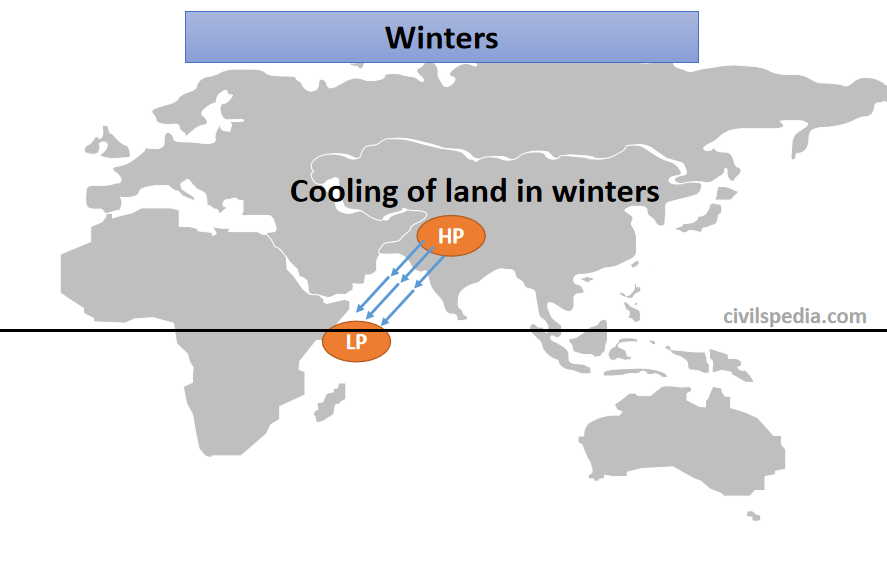
Winter Monsoon
During Winter, high pressure is developed over land, whereas low pressure prevails over oceans. Hence, winds start to blow from North-East towards South-West (North East Trade Winds).
These are dry & cold winds causing no rainfall except on the Coromandal Coast, where it gathers moisture after passing over the Bay of Bengal.
Shortfalls
But this presents a very simple picture and fails to explain the following:-
Why low-pressure areas on land are not stationary & suddenly change their location?
Why are there no anti-monsoon circulations in the upper-troposphere which must be there if they were thermally induced?
Low pressure in Northern India develops in April & May, but rain starts there in June. Why??
Monsoon rains are an amalgamation of convectional, orographic & cyclonic rainfall & the thermal concept fails to explain this.
2. Fohn Dynamic Concept of Monsoon
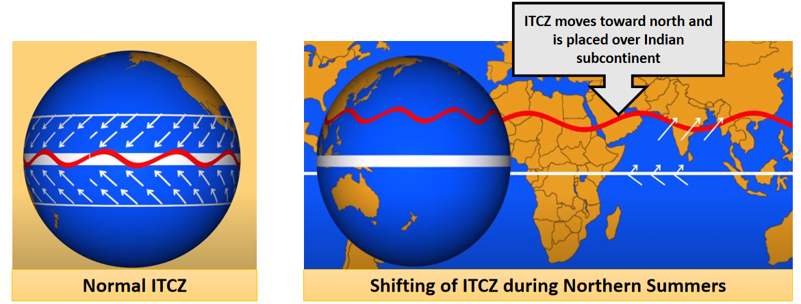
Fohn tried to explain the monsoons using shifting of ITCZ (Inter-Tropical Convergence Zone), i.e., where northern and southern Trade winds converge. This ITCZ zone keeps shifting towards the north and south according to the apparent movement of the sun.
According to this theory, Monsoon is the result of the seasonal migration of planetary winds & pressure belts around the Equator due to the apparent shifting of the sun during different seasons
During Summer, the sun moves directly above the Tropic of Cancer due to the apparent northward movement of the sun. As a result, all the pressure belts of the globe shift northwards. ITCZ moves up to 25° N & low pressure develops over the whole Indian Subcontinent. Trade winds blowing towards ITCZ need to pass through the Equator to reach ITCZ. Due to the Coriolis effect, while crossing the Equator, these winds get deflected and take the southwest direction, becoming a southwest Monsoon. Indian landmass gets rain due to these South-West winds as these winds carry moisture from the Indian Ocean to Indian Subcontinent.
During Winter, due to the apparent southward movement of the sun, all the pressure belts shift southwards. As a result, ITCZ moves southwards out of India, establishing the North-East Monsoon. Hence, during Winter, winds in India start to blow from North East to South West, creating a North-East monsoon.
3. Real Mechanism
But in reality, the mechanism is more complex than what even Fohn proposed. A large number of factors impact the Indian Monsoon & the exact mechanism is not known to date. Major factors which impact the Indian Monsoon are
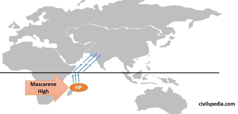
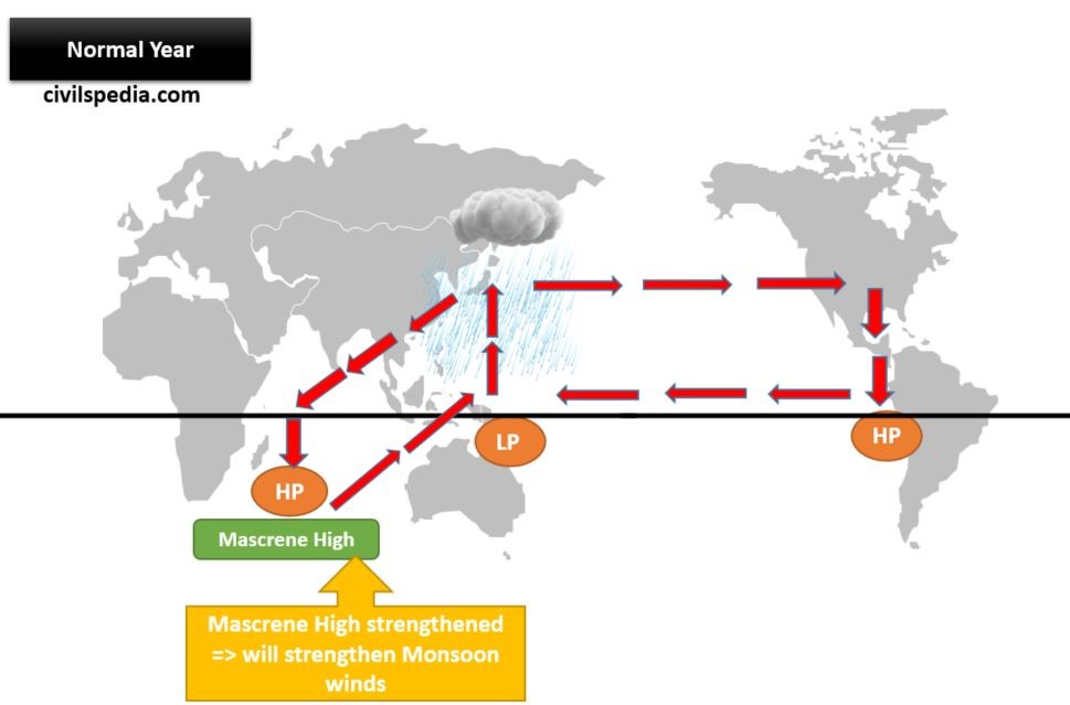
3.1 Maskarenes High
When there are summers in the North Hemisphere, there are winters in the Southern Hemisphere. As a result, a High-pressure zone develops near a small island in the Southern Hemisphere in the South Indian Ocean called Mascarene. Winds from this high-pressure area, termed as Mascarene High by scientists, start blowing towards low-pressure areas in the Northern Hemisphere, along the east Somalia coast.
The strength of Mascarene High is a crucial factor in determining the intensity of the Monsoon in India. Stronger is the Mascarene High, stronger will be the push caused by them and stronger will be the rainfall over Indian Subcontinent.
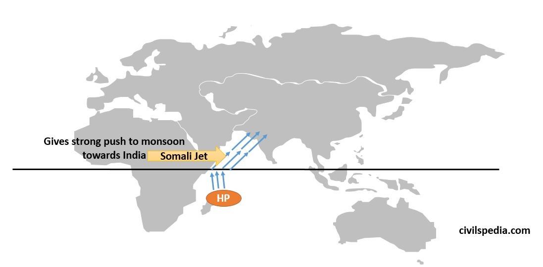
3.2 Somali Jet / Findlater’s Jet
The monsoon wind that is deflected to the east as it crosses the Equator (due to Coriolis Force) is further deflected to the east by the mountains of Africa on the Somalian Coast and Somali Jet. The Somali Jet transits Kenya and Somalia and exits the African coast at 9 degrees north at a low altitude at very high speed.
Hence, it gives a strong push to the Monsoon winds & also deflects them towards India.
(This Jetstream was discovered by J. Findlater, a British
meteorologist & it is most pronounced between 1.0 and 1.5 km above the
ground.)
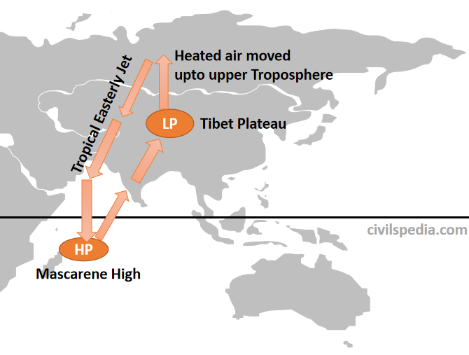
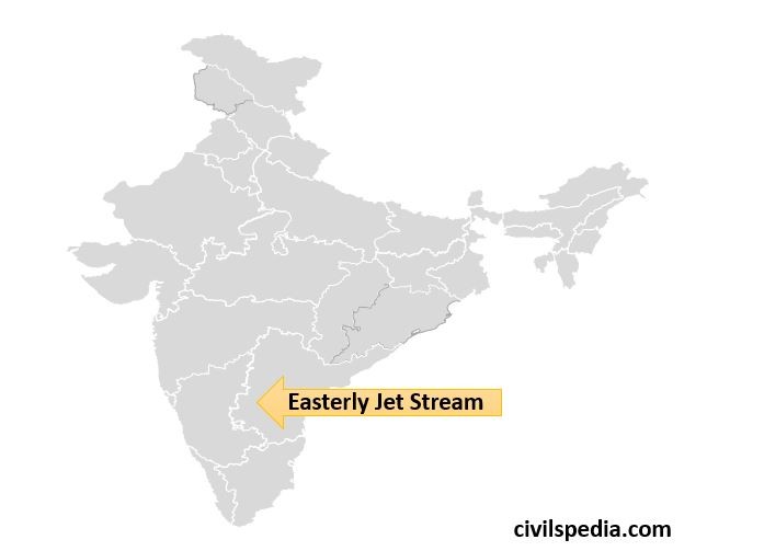
3.3 Tropical Easterly Jet / Role of Tibet Plateau
The first instance of the relationship between the Indian Monsoon and Tibet plateau came some 130 years ago, when Sir H.F. Blanford, Chief Reporter of the newly-established India Meteorological Department (IMD), noticed more Himalayan snow cover during the preceding Winter resulted in a poor monsoon. Hence, scientists began to study the relationship and reached the following explanation.
In summer, the apparent movement of the sun is northwards. Due to this, there is intense heating of land in Northern India & Tibet.
Since the Tibetan plateau is situated at a great height, it receives 2-3° C more insolation, and extreme low pressure develops there. As a result, air from Tibet Plateau rises to the Upper-Troposphere and starts moving towards Mascarene High in the form of a Tropical Easterly Jet. After reaching Mascarene high, it descends & further strengthens the Mascarene High-Pressure Cell.
More strength of Tropical Easterly Jet means stronger Mascarene High, which further means good rainfall in the Indian Subcontinent.
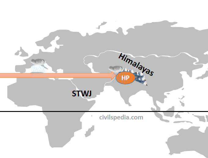
3.4 Sub Tropical Westerly Jet Stream
India is under the influence of Sub-Tropical Westerly Jet (STWJ). It impacts the Monsoon in the following ways
1. Winters
Due to the sun’s southward apparent movement during winters, all the earth’s pressure belts move southwards. As a result, STWJ also moves southwards & comes over North India (from the Himalayas).
These Jet streams create High-Pressure Zone over North India, so no rainfall occurs during Winter.
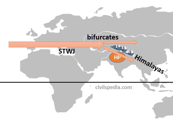
2. Summers
2.1 Early Summer
With the onset of summers, the sun starts to move northwards; as a result, pressure belts of the earth, along with STWJ, also starts to move northwards.
During early summers, half of the STWJ is over the Northern plains, while the other half moves north of the Himalayas. Hence, high pressure continues to be maintained over Northern India. Until the whole of STWJ doesn’t move out of North India, Monsoon cant strike Indian Subcontinent.
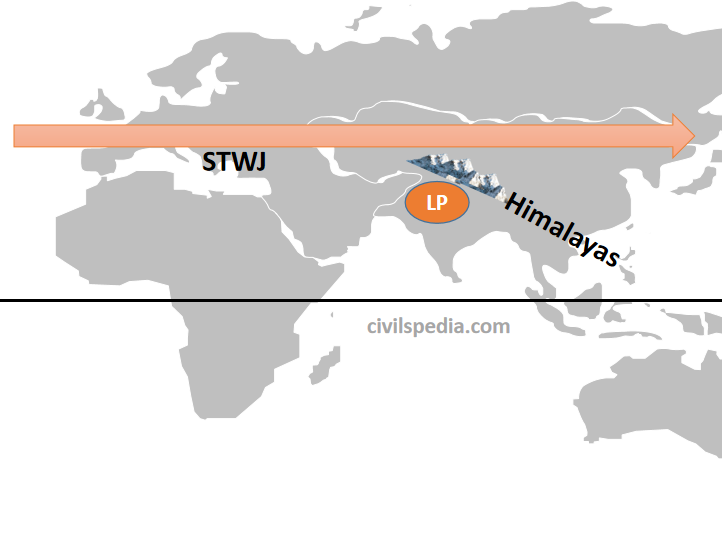
2.2 Late summer, near June
During late summer, STWJ entirely moves north of the Himalayas, and low pressure develops over North India. Hence, Monsoon strikes Indian Subcontinent in June.
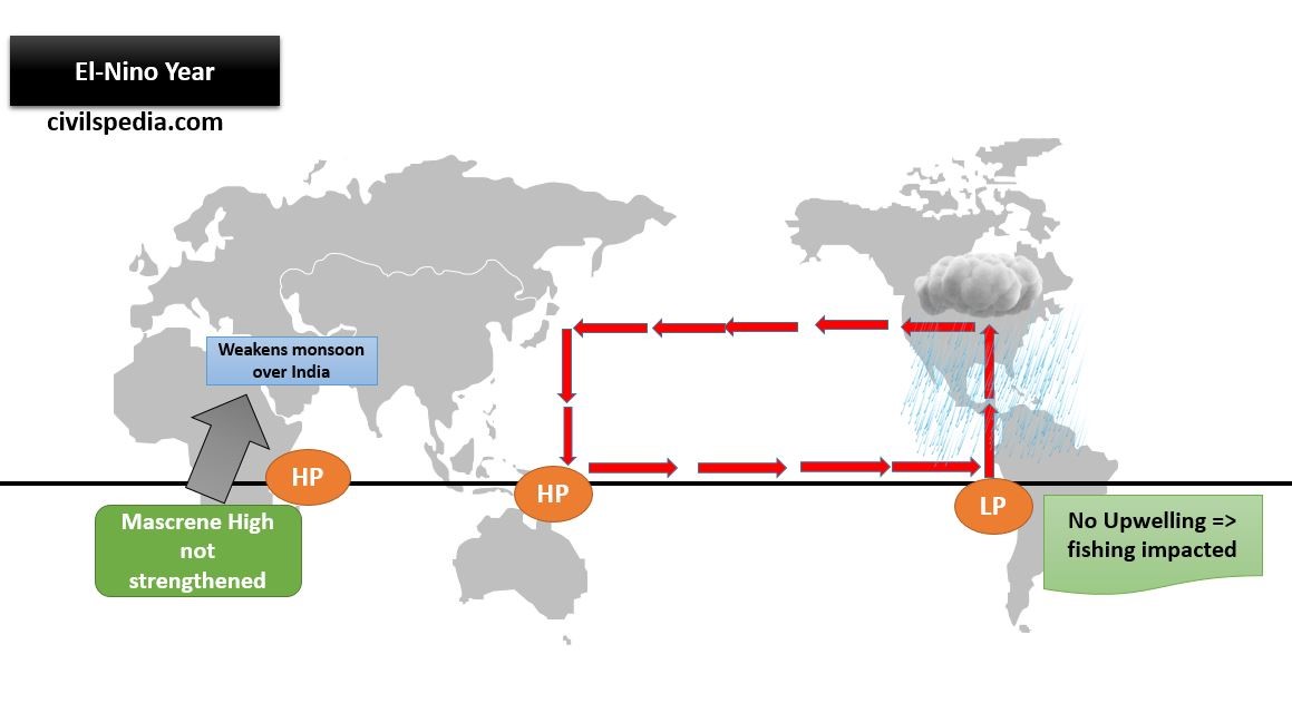
3.5 El Nino
El Nino creates High Pressure near Northern Australia & as a result, Walker Cell between Western Pacific Pool (WPP) and the Western Indian Ocean (Mascarene High) is altered. In normal conditions, this Walker Cell helps to strengthen the High Pressure in the Western Indian Ocean. But during El Nino, Mascarene High is not strengthened.
As Mascarene High helps push monsoon winds towards India, in case of weak Mascarene High during El-Nino years, the push would be weaker, resulting in lower rainfall in Indian Subcontinent.
La Nina
La Niña is the reverse of the El-Nino. Here, extreme Low Pressure prevails over Northern Australia. It strengthens the Mascarene High more than what happens in normal conditions.
La Niña years are infamous for frequent and intense hurricanes and cyclones in the Atlantic Ocean and the Bay of Bengal, likely due to multiple aiding factors, including high relative moisture and relatively low wind shear over the Bay of Bengal.
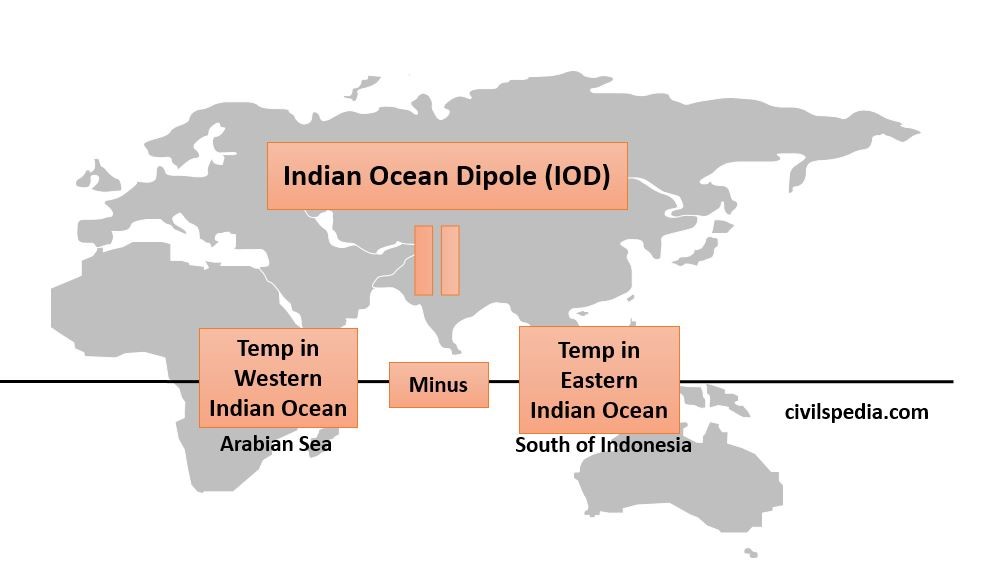
3.6 Indian Ocean Dipole (IOD)
In 1999, N H Saji of Japan’s University of Aizu and others discovered an El-Nino Southern Oscillation (ENSO) -like phenomenon in the Indian Ocean, which they named the Indian Ocean Dipole (IOD).
The Indian Ocean Dipole (IOD) is defined as the difference in the sea surface temperatures between two poles, i.e. Western pole in the Arabian Sea (western Indian Ocean) and the Eastern pole near Indonesia in the eastern Indian Ocean.
The IOD affects the climate of Australia, India and other countries surrounding the Indian Ocean and is a significant factor in deciding the rainfall variability in this region.
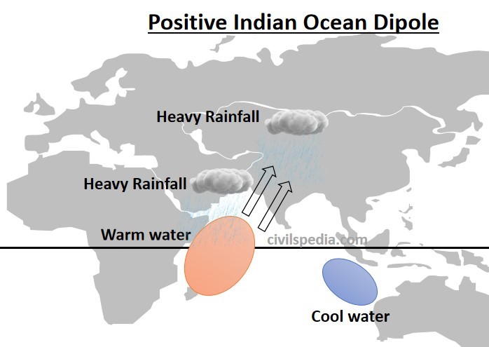
Case 1: Positive IOD
In this, waters in the Western Indian Ocean (Arabian Sea) become relatively warm compared to waters in the Eastern Indian Ocean (south of Indonesia).
Studies have shown that a positive IOD year sees more than normal rainfall in central India. It happened in 1994 and 1997.
Point to note: The Indian Ocean Dipole (IOD) and El Nino
are independent climatic phenomena but
often co-occur. When they co-occur (60% of the time), then two
competing factors come into play at the same time i.e.
El-Nino reduces high pressure at Mascarene high, which negatively impacts the Indian Monsoon.
But at the same time, positive IOD favours good rainfall over Indian Subcontinent.
This is the reason why we can’t say with certainty that El-Nino
will result in lower rainfall over Indian Subcontinent. In 1997, there was
intense El-Nino but above-average rainfall in India; in 2002, there was
moderate El-Nino but intense drought in India. The reason for this was in 1997,
there was a positive IOD which overpowered El-Nino, but in 2002 there was a
Negative IOD which exacerbated the impacts of El-Nino.
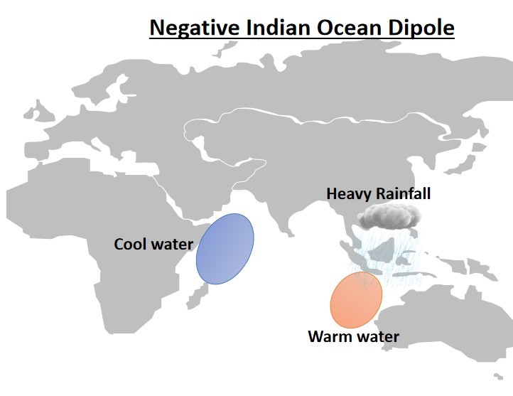
Case 2: Negative IOD
In this, waters in the Eastern Indian Ocean (south of Indonesia) become relatively warm compared to waters in the Western Indian Ocean (Arabian Sea).
In this case, more rainfall will happen in southern Indonesia and the eastern Indian Ocean.
Note: Worst drought occurs when El-Nino and Negative or Neutral IOD co-occur.
This article deals with ‘Introduction to Indian Climate.’ This is part of our series on ‘Geography’, which is an important pillar of the GS-1 syllabus. For more articles, you canclick here.
General Observation
India has an extraordinary variety of climates ranging from Tropical to Alpine.
The climate of India can be broadly described as Tropical Monsoon Type.
It is most affected by two seasonal winds.
South-West Monsoon
– Blow from sea to land after crossing the Indian ocean, Arabian sea & Bay of Bengal. – Bring most of the rainfall in the country.
North-East Monsoon
– They blow from land to sea. – Cause rainfall only on the Coromandal coast.
The whole of India can be broadly divided into two climatic zones.
North India
Continental Climate with winters freezingly cold & summers with extremely high temperature
South India
Equable Climate, i.e. same temperature throughout the year
Factors affecting Climate in India
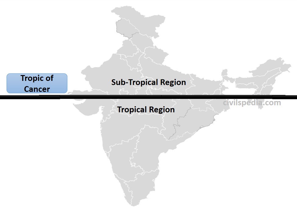
1. Longitudinal Extend
Since
the Tropic of Cancer passes through the middle of India. Hence,
Northern India lies in the subtropical & temperate zone
Southern India falls in the tropical zone.
2. Distance from Sea
Places situated near the sea have Equable Climates. A large area of India, especially the Peninsular region, is not very far from the sea. This part of the country does not have a very clearly marked winter, and the temperature is almost equal throughout the year. Kerala, situated on the coast, has an annual range of temperatures less than 3° C.
On the other hand, places situated away from the sea have Continental climates. In areas of central and north India, summers are hot, and winters are cold.
3. Altitude
Every 1000 metres of elevation gain results in a 6.5°C drop in temperature. Hence, places situated at higher altitudes are cooler than places on the plains.
4. Mountain Ranges
4.1 Himalayan Mountains
The Himalayas acts as a barrier to the freezing cold wind blowing from central Asia and keep the Indian subcontinent warm compared to Central Asia.
The Himalayas compel the South-West monsoon to shed whole rainfall in India.
4.2 Western Ghats
Significant rainfall happens on the western slopes of the Western Ghats. In contrast, the eastern slopes & Deccan plateau receive very little rain as they lie in the rainshadow region of Western Ghats.
5. Direction of Surface Winds
Summer: winds blow from sea to land, bringing widespread rain.
Winter: winds blow from land to sea, and hence, they are dry & cold.
6. Upper-Air Circulation
They affect Indian Climate in the following ways
The onset of the South-West Monsoon is driven by the shift of the Sub-Tropical Westerly Jet (STWJ) from the plains of India towards the Tibetan plateau (explained in the next article in detail).
Sub-Tropical Westerly Jet (STWJ) reaches India after passing over the Mediterranean Sea, where rainfall occurs during winters. These winds bring cyclonic disturbances to Northern India, causing rain in Northern India during winters known as Western Disturbances.
The Tropical Easterly jet streams that blow over Peninsular India (approx. 14° N during summer) cause tropical depressions during the South-West and retreating monsoon.
This article deals with ‘Introduction to Mineral Resources of India.’ This is part of our series on ‘Geography’, which is an important pillar of the GS-1 syllabus. For more articles, you canclick here.
Introduction
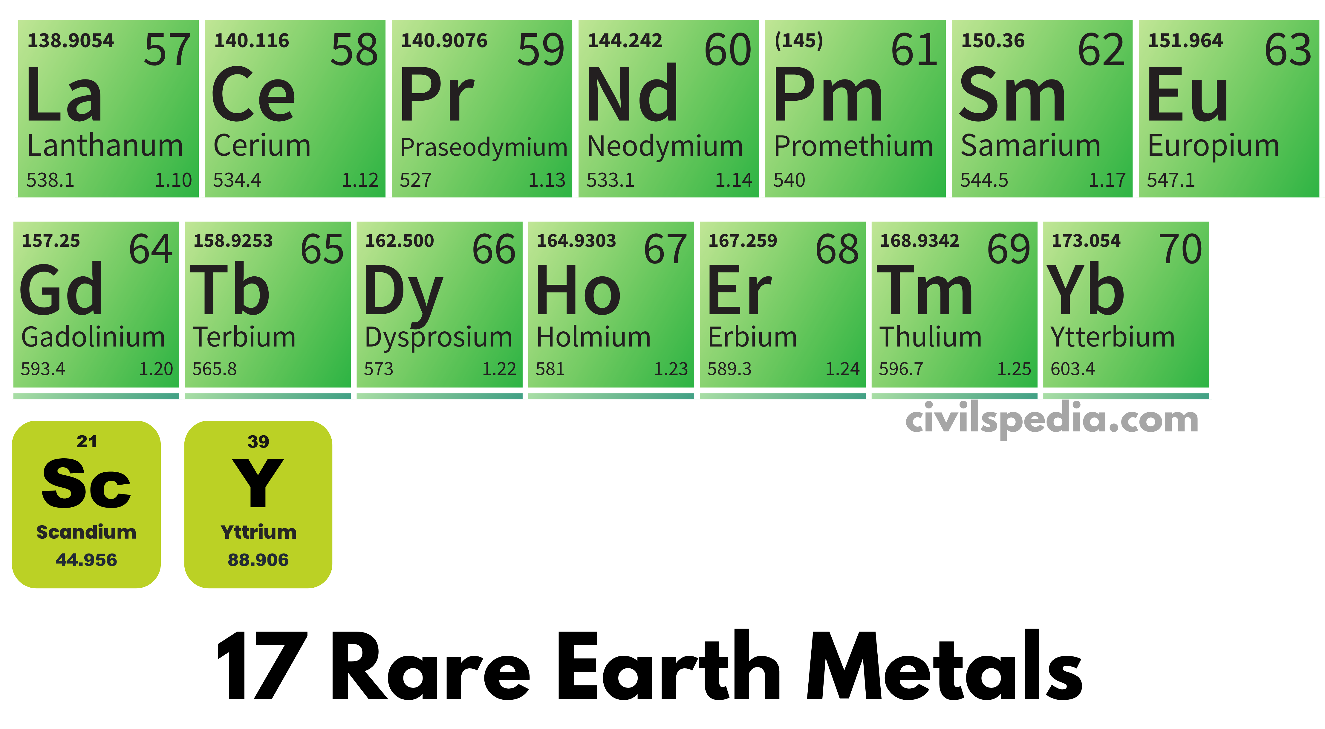
Rare Earth Metals include 15 lanthanides with Atomic numbers 57 to 71 and two non-lanthanide metals, i.e. Scandium and Yttrium.
As they frequently occur in the same ore deposits as the lanthanides and have comparable chemical characteristics, scandium and yttrium are also regarded as rare-earth elements. But they have different electronic and magnetic properties.
Although they are termed Rare Earth elements, they are not so rare in occurrence. However,
They tend to occur together and are difficult to separate from one another.
Along with that, they do not occur in concentrated form and are dispersed throughout the world. It makes their extraction difficult and economically unviable.
They are also hazardous to extract due to their radioactive nature.
Two main ores from which Rare Earth Metals can be extracted are Monazite and Bastansite.
Uses of Rare Earth Metals
Due to their useful magnetic, chemical, and spectroscopic properties, they are used in various high-end electronic devices, including smartphone chips, batteries, LCD screens, military equipment, etc.
They have the unique property to accept and discharge electrons, enabling them to be used in electronic devices, rechargeable batteries & fluorescent lighting.
Due to their spectroscopic properties, they are used as fluorescent and as the main component in night vision glasses.
Due to their magnetic properties, they are used in electromagnetic circuits and also to make powerful and stable magnets.
Military uses
They are used in night-vision glasses & precision-guided weapons.
They are the critical component in making ultra-hard alloys used in making armoured vehicles.
Some Rare Earth Metals and their uses
Scandium: Television and fluorescent lamps
Yttrium: Treat cancer and rheumatoid arthritis
Lanthanum: Night vision glasses
Neodymium: Guidance systems and wind turbine motors + making Neodymium-Iron-Boron Magnets crucial for EV manufacturing (motors of EVs)
Europium: Fluorescent lamps
Samarium: Powerful permanent magnets which are stable even at high temperature
Cerium: Space program, especially space shuttles
Global Distribution
There are two main sources
Bastnasite deposits in China and the United States constitute the largest percentage
Monazite deposits found in Australia, Brazil, China, India, Malaysia, South Africa, Sri Lanka and Thailand.
China is the world leader, accounting for around 97% of world production. India, Brazil, Australia, the USA, Russia, Thailand and Malaysia comprise the rest.
In 2023, large deposits of rare earth metals were found in Sweden. Until then, no rare earth deposits have been reported from the continent.
Rare earth metals are also being recycled from e-waste.
Indian Distribution
India has 3% of world reserves.
The main source in India is monazite which is found in the form of sand on the beaches of Kerala.
The Geological Survey of India recently found a high concentration of rare earth elements in western Rajasthan.
Hyderabad-based National Geophysical Research Institute has recently found large deposits of Rare Earth Elements in Andhra Pradesh‘s Anantapur district.
Note:
Minerals Security Finance Network (MSFN): It is a US-led initiative to strengthen cooperation between the member countries to secure the supply chains of critical minerals. India is part of the initiative.
Quad Critical Mineral Initiative: In 2025, Quad has initiated Quad Critical Mineral Initiative to strengthen, secure and diversify critical mineral supply chains (to counter China’s stranglehold).
Last Updated: July 2025 (Types of Vegetations in India)
Types of Vegetations in India
This article deals with ‘Types of Vegetations in India.’ This is part of our series on ‘Geography’, which is an important pillar of the GS-1 syllabus. For more articles, you canclick here.
Introduction
Natural vegetation refers to a plant community unaffected by man, directly or indirectly.
Climate, soil and landform characteristics are the important environmental controls of natural vegetation.
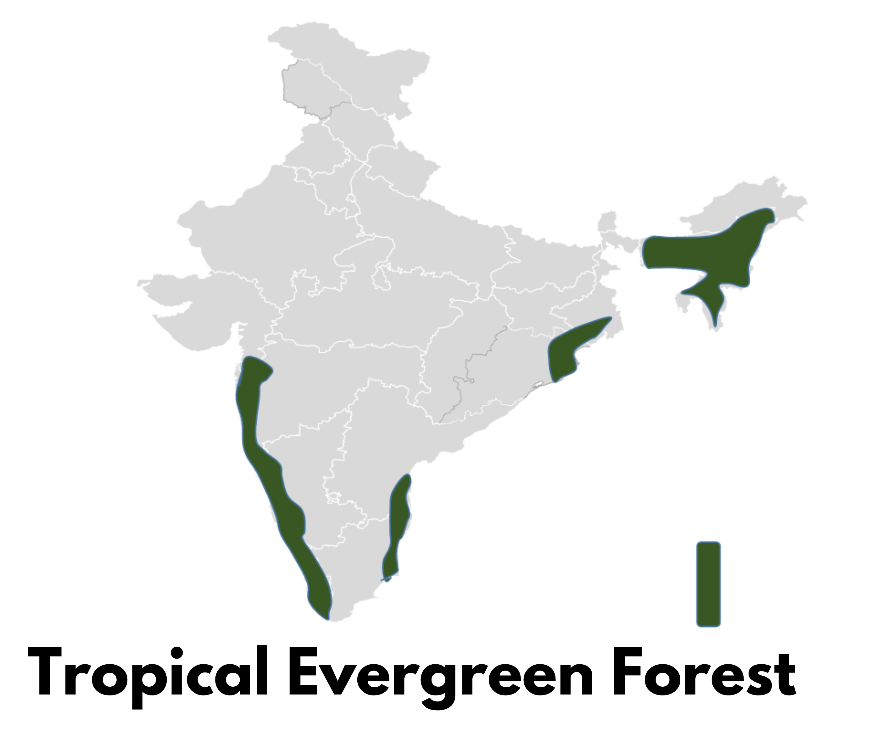
1. Tropical Evergreen Forest
Tropical Evergreen Forests are found in areas with
200 cm or more annual rainfall
Annual temperature of more than 22°C
Rainfall is distributed throughout the year.
These forests never shed their leaves; therefore, they are called evergreen forests.
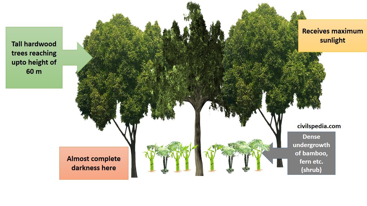
The temperatures in these regions are high enough to promote constant growth, and water is always sufficient. The only physical limitation for vegetation growth is light, which sets a competition between adjacent species for light. Due to this reason, Tropical evergreen forests are dense, vertically stratified and multi-layered.
The tallest trees, to ensure maximum sunlight goes up to the height of 60 meters and have a branched canopy. They receive maximum sunlight.
Vegetation layers closer to the ground consisting of shrubs and creepers receive very low sunlight due to darkness in this area.
Vegetation in this region consists of
Trees: Rosewood, Mahogany, Aini, Ebony,Ironwood, Cinchona (bark used to make quinine), and Cedar (all hardwoods). Their height is up to 60 meters, and their bark is up to 5 m thick.
Dense undergrowth: Bamboo, Fern, Canes & Climbers
Though this is a hardwood type of vegetation, due to high density, lack of pure strands and swampy ground conditions, it is not easy to exploit these forests. Also, due to the lack of transportation facilities, their full economic benefits have not yet been realised.
They are found in
Western Ghats in Maharashtra, Karnataka and Kerala
Parts of Tamil Nadu and Andhra
Andaman-Nicobar Islands
Plain areas of West Bengal and Odisha
North-Eastern states of Assam, Nagaland, Tripura, Mizoram, Manipur and Meghalaya
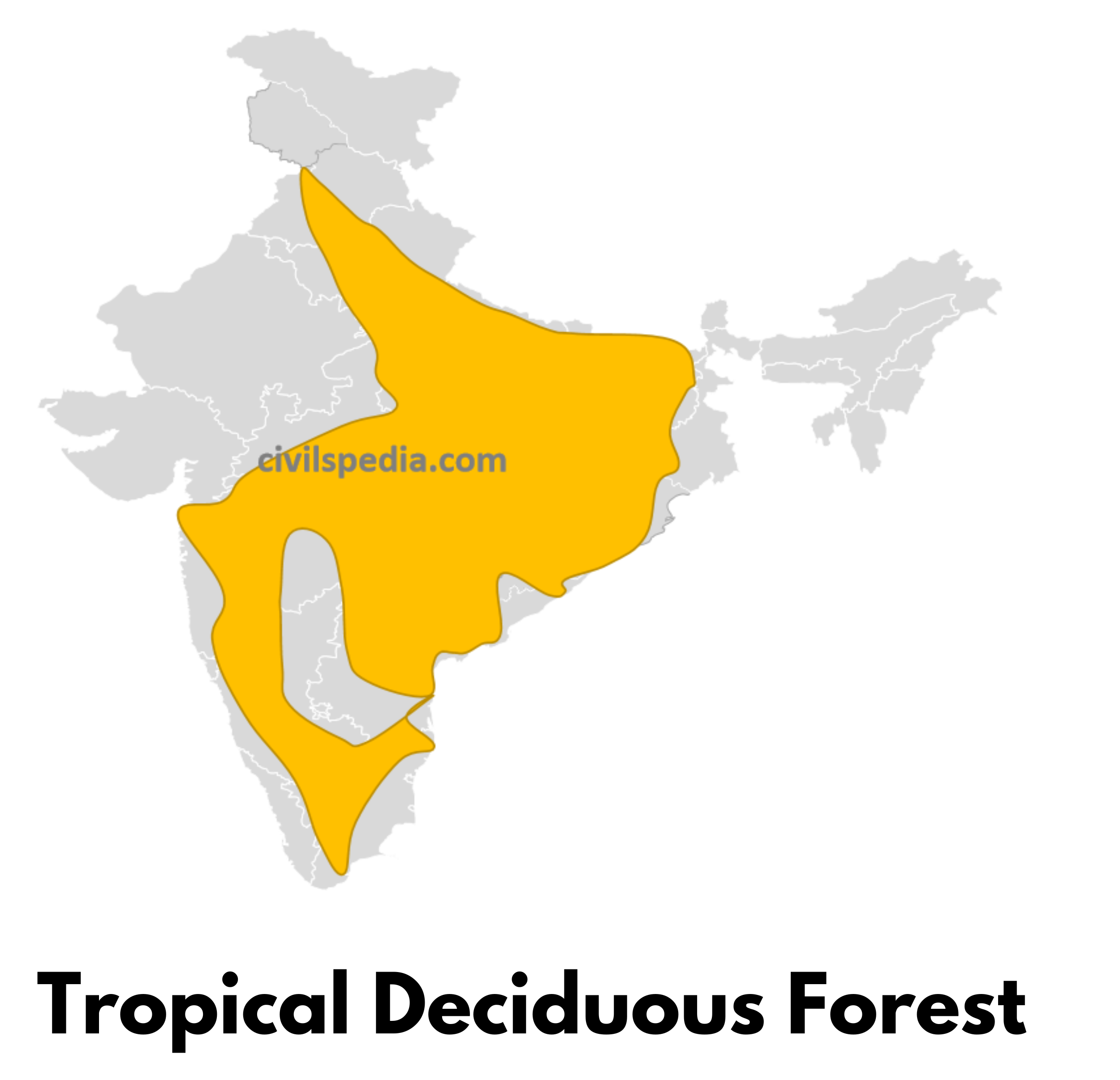
2. Tropical Deciduous Forest
Tropical Deciduous Forests develop in areas with
70 to 200 cm annual rainfall
Annual temperature of about 27°C
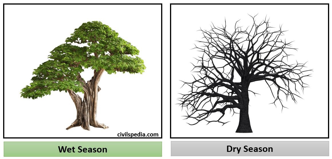
But there is a distinct dry and wet season.
The characteristic feature of the Deciduous forest: This vegetation sheds its leaves due to stress during the long dry season, which occurs at the time of low sun and cool temperatures.
Vegetation in this region consists of
Teak and Sal are the most important trees.
Rosewood, Kusum, Pipal, Neem, Teak, Eucalyptus, Mahua, Amla, and Tendu are also found.
They are found in regions having tropical monsoon climates i.e.
Great Plains: Punjab, Haryana, Uttar Pradesh, Bihar and West Bengal
Central India: Jharkhand, Madhya Pradesh, Chhattisgarh,
South India: Maharashtra, Karnataka, Telangana, Andhra Pradesh and Tamil Nadu
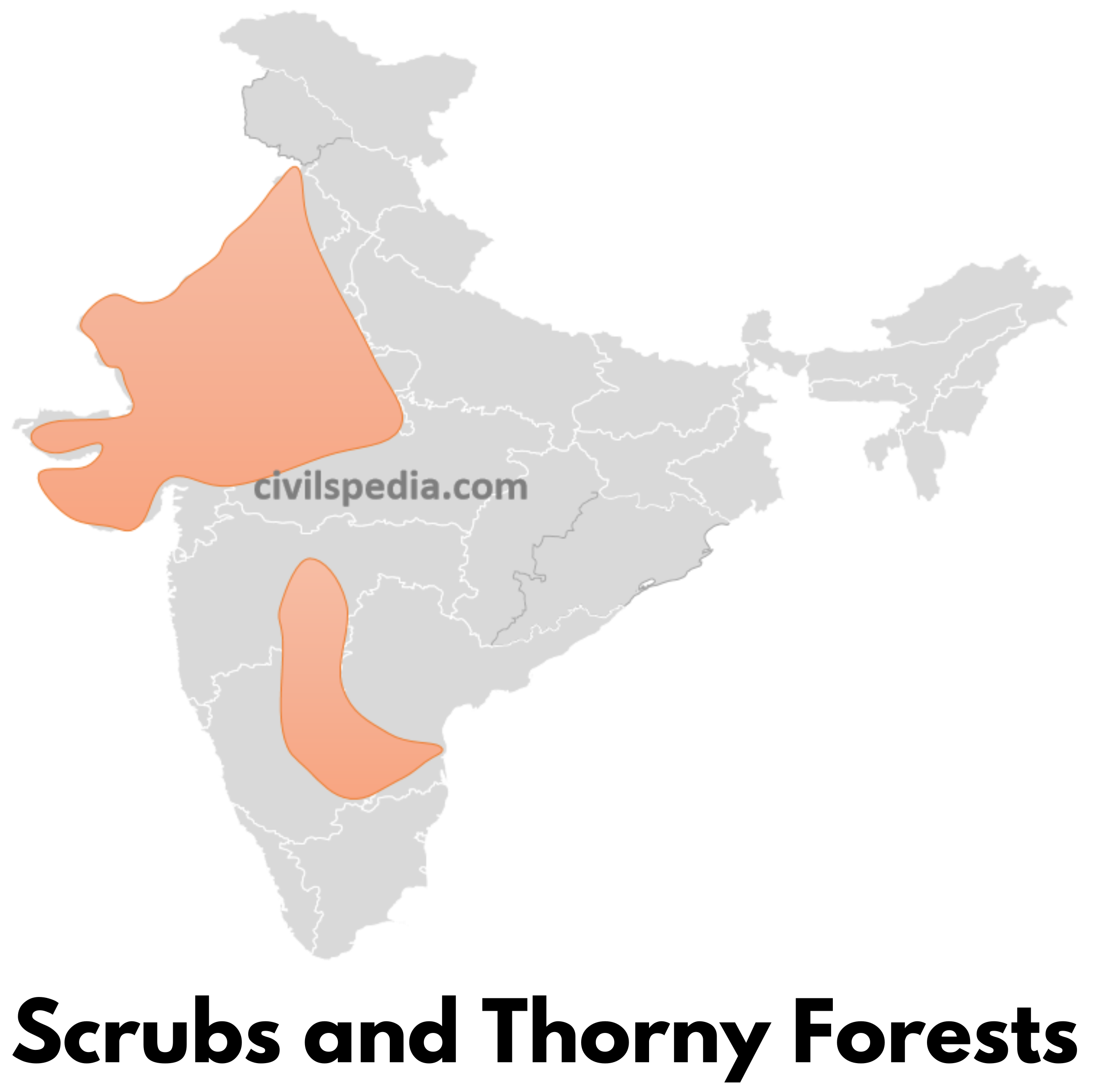
3. Scrubs and Thorny Forests
Scrubs and thorny forests are found in areas with
Annual rainfall of less than 70 cm.
Annual temperature of about 27°C
In such regions, Xerophytic vegetation is found, which has the following characteristic features to conserve moisture.
Long roots to extract moisture
Thick barks to store water
Waxy leaves, thorns and small leaves to avoid evapotranspiration
Vegetation in this region consists of
Trees: Kikar, Babul , Pipal, Palm, Khejri , Ber, Neem etc.
Xerophytes like Cactus
Grasses like Munj, Tussocky etc.
These forests are found in
West of Aravallis in Rajasthan
South Punjab and South Haryana
Gujarat
Interior rain shadow areas of the Deccan Plateau
4. Mountain or Montane Forest
This type of vegetation is found in India in the Himalayas in the north and Nilgiri hills in the south.
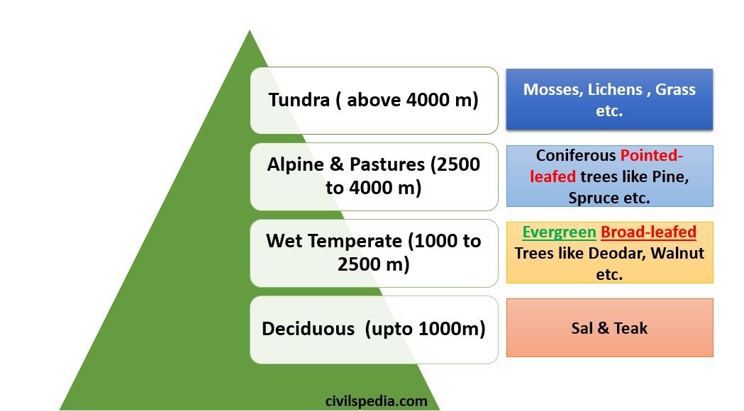
4.1 Himalayan Montane Forests
All type of vegetation available worldwide is found in the Himalayan region. The Himalayan mountains exhibit a succession of vegetation, ranging from tropical to tundra, with changes in altitude
The natural vegetation found on hill slopes is affected by the difference in temperature and rainfall with increasing height.
Upto 1000 m
Mixed trees of deciduous vegetation are found, like Sal and Teak.
1000 to 2500 m
There is a decrease in temperature and an increase in precipitation. Hence, wet-temperate vegetation is found here, which consists of evergreen broad-leaf trees such as Deodar (highly durable wood used in construction), Chinar and Walnut (in Kashmir and used in handicrafts) etc.
2500 to 4000 m
With an increase in temperature and a decrease in precipitation, this region contains Alpine vegetation and pastures. Pointed-leafed coniferous trees like pine, spruce, rhododendrons etc., are found here.
Pastures of this region are used extensively by tribes like Gujjars, Bakarwals, Bhotiyas and the Gaddis.
Above 4000 m
These areas are above the snowline, and Tundra vegetation is found in this region, containing mosses, lichens, natural grasses and flowers.
4.2 South Indian Montane Forests
These forests are found in three distinct regions of Peninsular India viz; the Vindhyas, the Western Ghats and the Nilgiri.
It is different from the Himalayas because
They are closer to the tropics
Their height is only 3000 m above the sea level at max
Two different types of vegetation are found in
accordance with increasing height
Lower regions
Subtropical vegetation is found in this region
Higher regions
Temperate vegetation is found here.
In Nilgiris, Annamalai and Palani Hills, these Temperate forests are known as Sholas.
Shola forest has a high degree of endemism, i.e. concentration of species that are not found anywhere else in the world.
Shola forests on the higher reaches of the Western Ghats are like “patches of forests floating in a sea of grassland.”
5. Littoral and Swamp Forests
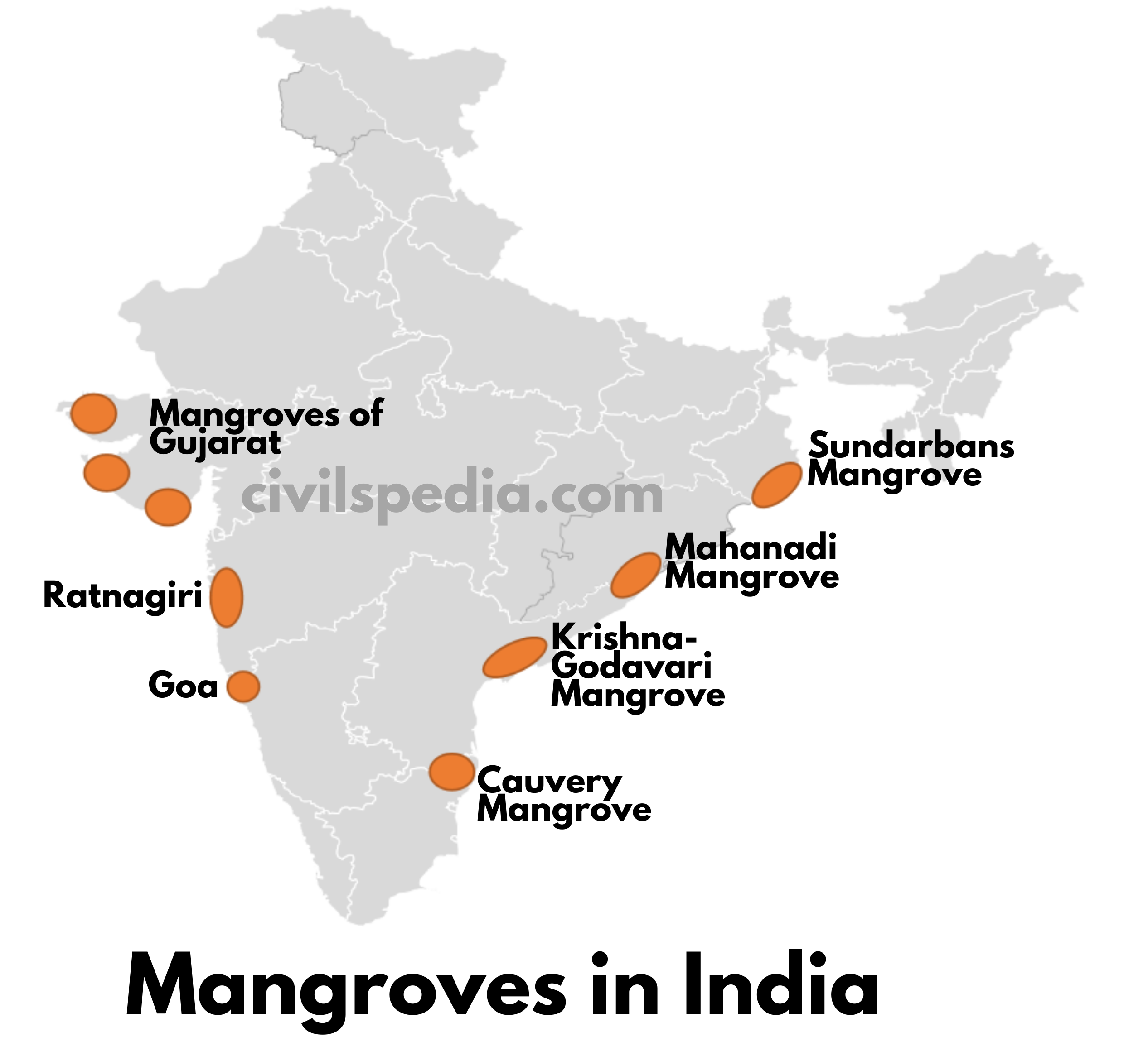
This vegetation is found in the deltaic areas of rivers like the Ganges, Brahmaputra, Krishna, Cauvery, Godavari and Mahanadi.
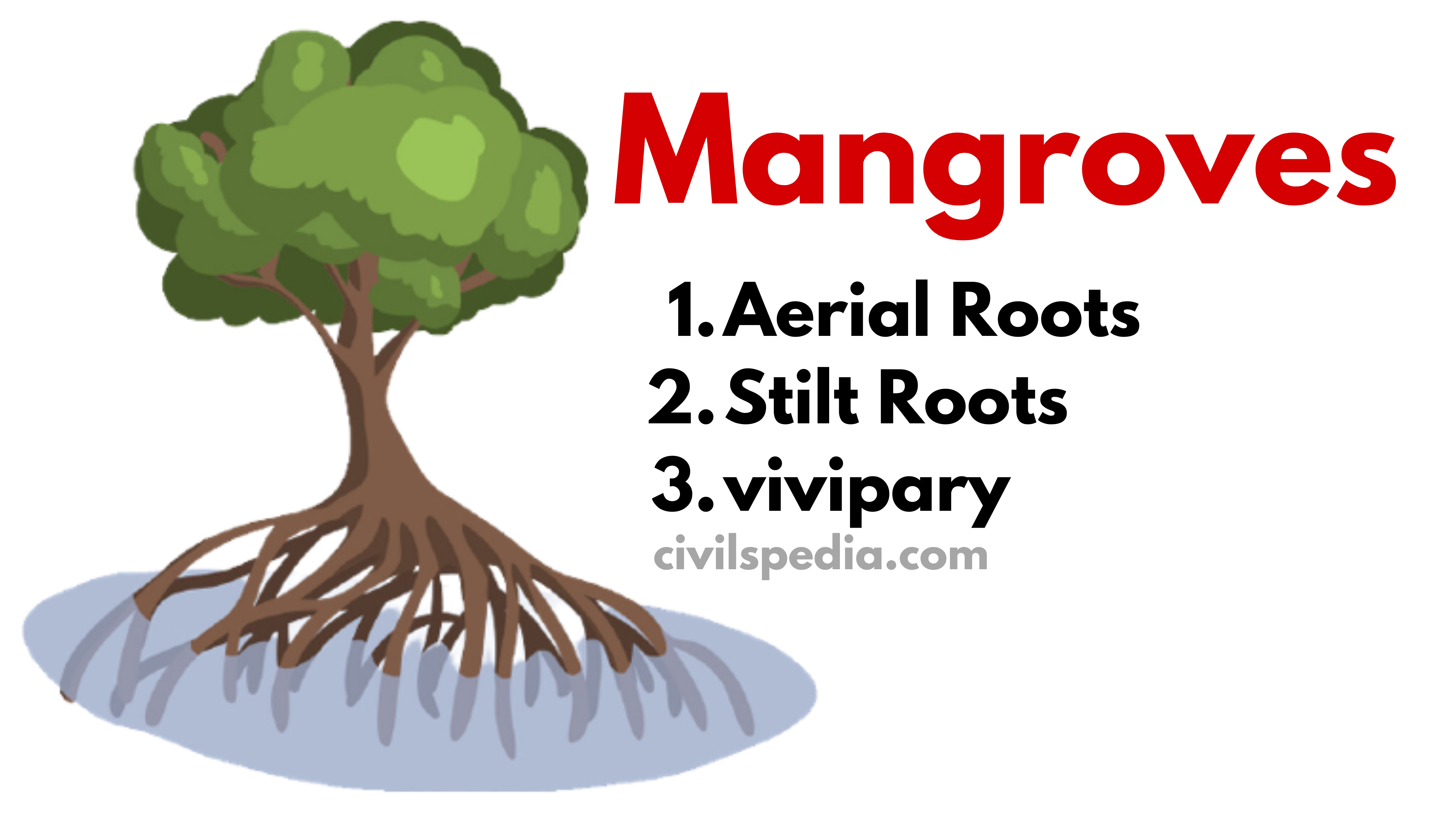
Here, seawater at the time of tides keeps entering the deltaic areas. Due to this, the soil becomes marshy and saline, and normal vegetation can’t survive there. A special type of salt-tolerant plant called Mangroves is found here, which has adapted itself to survive in these conditions with features like
aerial roots (roots above ground for breathing)
stilt roots (roots below water to hold the tree against the tides) and
vivipary (special technique of germination – The seeds actually germinate on the tree itself, and then fall of from the tree into the water, taking root only when encumbered by mud and sediment. This is very unique adaptation in the mangroves that helps them perpetuate in the harsh saline conditions.)
The Sundari tree is also found in abundance. Therefore, the Ganga-Yamuna delta is known as the Sundarbans delta. Sundari tree provides valuable timber for making boats.
This type of vegetation is also called Mangroves or Sundarbans vegetation.
West Bengal has the largest mangrove cover in India. Gujarat comes second with an estimated area of 1,177 sq km
Side Note: Importance of Mangroves
It provides a Buffer Zone between the land and sea.
Mangroves protect coastal land from erosion.
Mangroves serve as the natural defence against cyclones and other calamities that threaten the environment.
Supports Biodiversity: A wide range of living species, including invertebrates, fish, amphibians, reptiles, birds, and even mammals such as tigers, can be found in mangroves.
Carbon Sinks: Huge volumes of carbon dioxide are removed from the atmosphere by mangrove forests, and their preservation can help to control and combat climate change.
Mangroves clean the air by absorbing pollutants in the air and cleanse the water by absorbing contaminants and dangerous heavy metals.
Economic Significance:
Mangroves are a potential source of recreation and tourism.
Fishermen and Farmers depend on Mangroves for fish farming, timber forest produce, etc.
Side Note: Causes of degradation of Mangroves
1. Natural Causes
Cyclones, typhoons, and strong wave action damage mangroves
Attack of insect pests such as wood borers and caterpillars (which eat the mangrove foliage and damage the wood).
Global warming and subsequent sea-level rise have reduced the area fit for Mangroves.
2. Human Causes
Human Encroachment: The increasing human population in coastal areas results in increased pressure on mangrove ecosystems in many countries, including India.
Oil spills and other accidents: As happened recently in Sundarbans
Mangrove Alliance for Climate (MAC)
It was launched at CoP-27 (Sharm El-Sheikh, Egypt (2022)).
The initiative is led by the UAE and Indonesia. India is also one of its founding members.
It aims to raise awareness about the potential benefits of mangroves as a climate change solution and their role in reducing global warming.
Mangroves for the Future (MFF)
A regional initiative co-led by IUCN and UNDP to protect coastal ecosystems and livelihoods.
Initially focused on tsunami-hit countries (India, Sri Lanka, Indonesia, etc.), now expanded to include Bangladesh, Myanmar, Pakistan, etc.
Indian Initiatives for Mangrove Protection
MISHTI (Mangrove Initiative for Shoreline Habitats & Tangible Incomes)
Launched in 2023 by Ministry of Environment
Focus: Promote mangroves as bio-shields and carbon sinks.
Amrit Dharohar – Encourages wetland and mangrove conservation.
SAIME (West Bengal) – Sustainable aquaculture in mangroves.
Green Tamil Nadu Mission – Plantation drives in coastal regions.
Vana Samrakshana Samitis (Andhra Pradesh) – Community-led protection of mangrove areas.
This article deals with ‘Soil Erosion ’ This is part of our series on ‘Geography’ which is an important pillar of the GS-1 syllabus. For more articles, you canclick here
Introduction
The removal of the top 15 to 30 cm thick layer of soil by natural agents such as water, wind, glaciers and human activities is called soil erosion.
Agents of Soil Erosion
Wind
and water are the most powerful agents of soil erosion
Wind Erosion: It is the most potent agent of soil erosion in arid and semi-arid regions
Water Erosion: In areas with heavy rainfall and steep slopes, water erosion becomes significant
Types of Erosion
a. Sheet Erosion
In this type of erosion, a thin sheet (layer) of soil is eroded uniformly from a large area by wind or running water.
It is not easily noticeable but is harmful since it removes the finer and more fertile topsoil.
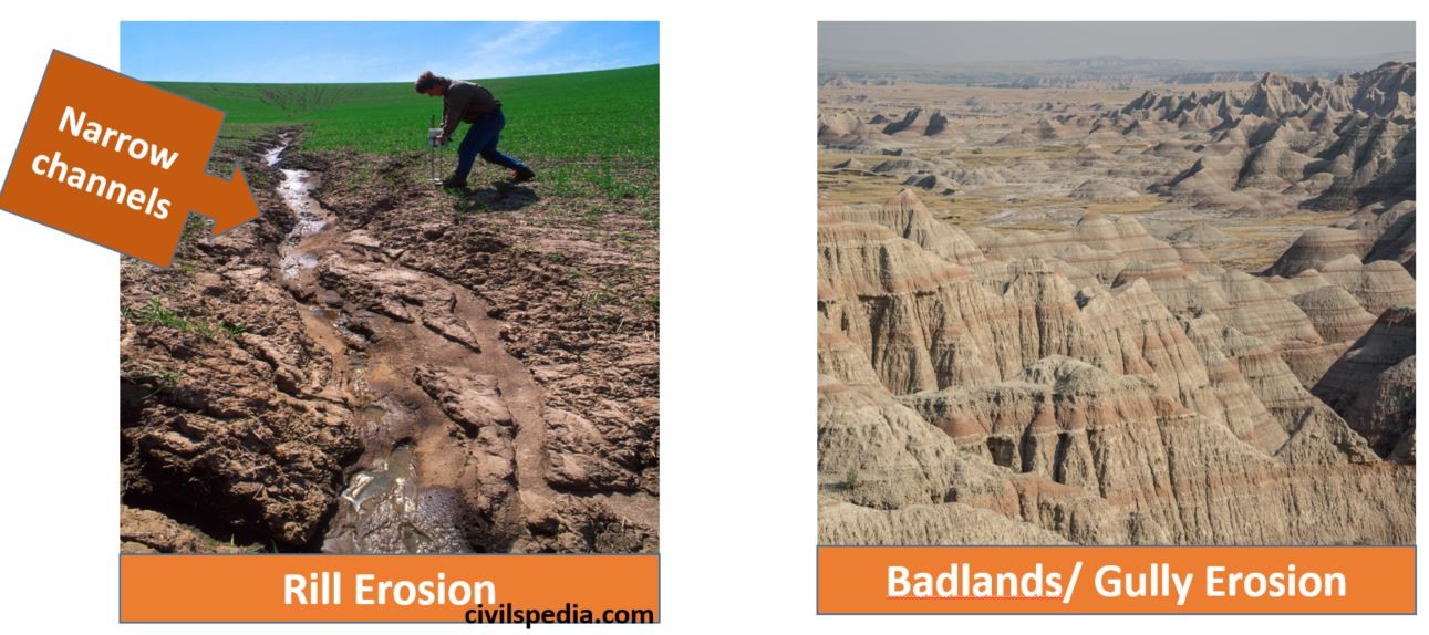
b. Rill Erosion
During heavy rainfall, water flows in the form of narrow channels along the slope of the land. Many finger-shaped grooves are formed over the surface.
c. Gully Erosion
It is an extreme type of rill erosion.
In areas of the steeper slope, Rills deepen with rainfall to form ravines, cut the agricultural lands into small fragments and make them unfit for cultivation.
A region with a large number of ravines is called a badland topography. It is widespread in theChambal basin.
Reasons of Erosion
Human-Induced Reasons
Deforestation: Deforestation is one of the major causes of soil erosion. Plants keep soils bound in locks of roots and, thus, prevent erosion.
Brick making: Top layer of soil used in making bricks.
Overgrazing: Loss of grass cover exposes soil to erosion.
Faulty Agro-practice: Like Shifting Agriculture or Ploughing along the slope with no barrier to the movement of loose soil particles by wind and water
Natural Reasons
Water & Wind erosion
Landslides, Volcanic eruptions and flooding
Side-cutting of river banks
Implications of Erosion
Eroded materials are carried down to rivers, lowering the river’s carrying capacity and causing frequent floods.
It leads to the loss of topsoil, which is the most fertile. Hence, the productivity of the soil is reduced.
Soil erosion from agricultural land causes eutrophication in ponds, tanks, oceans & other water bodies.
Events of landslide increase.
Natural hideouts to carry out nefarious activities are formed in the case of Gully Erosion (Chambal Valley is famous for dacoits).
Methods to prevent Soil Erosion
Methods to prevent
soil erosion can be divided into structural and non-structural solutions.
a. Structural Solutions
1. On the Slopes
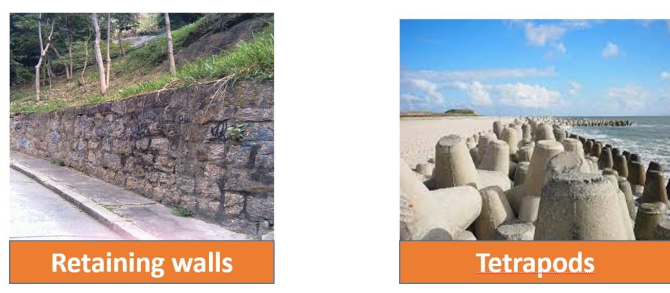
Construction of retaining wall along slopes.
2. On the Coastal Areas
Using Tripods & Tetrapods: Wave action is held back & erosion is prevented
3. On the Rivers
Strengthening slopes of river banks using stone pitching or wire netting.
b. Non-Structural Solutions
1. Afforestation
Vegetation holds the soil particles firmly and restricts soil erosion.
Creating windbreaks: Trees are planted in rows to create windbreaks to reduce the velocity of winds in Punjab, Haryana, Rajasthan, Gujarat, Uttaranchal and Uttar Pradesh.
Agroforestry: Tree plantations on the sides of agricultural field act as barriers to fast-moving winds
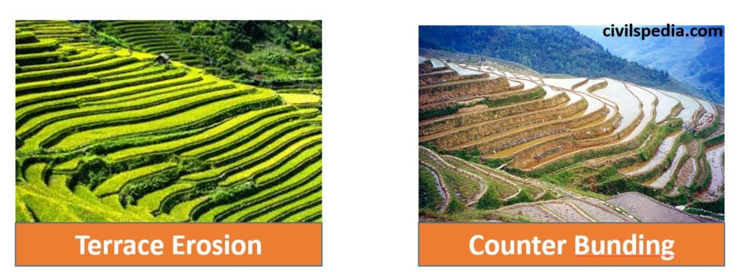
2. Along Slopes
Terrace farming: Slows the speed of the water
Contour bunding: Barriers at the edge of the slope are created to slow down water.
3. Agricultural practices
Relay farming: Multiple crops are grown in the same field, and the field is never left open. It is practised in Uttarakhand.
Strip farming: The field has a layer of one crop and then of another.
Avoiding overgrazing of grasslands
4. Other Solutions
Allowing indigenous plants to grow along the river banks.
Encouraging biological diversity by planting several different types of plants together.
This article deals with ‘Soils of India ’ This is part of our series on ‘Geography’ which is an important pillar of the GS-1 syllabus. For more articles, you canclick here
Introduction
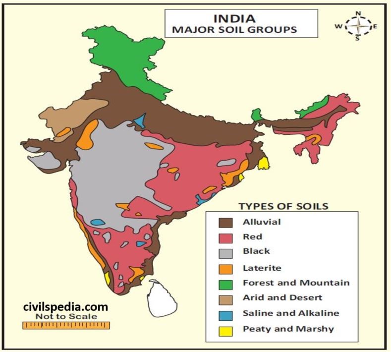
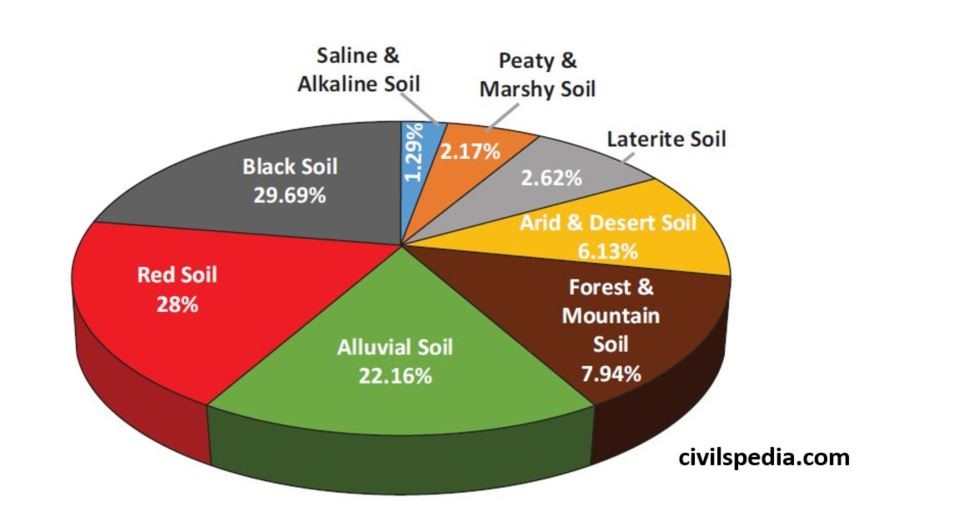
Indian Council of Agriculture Research (ICAR) divides the soils of
India into the following eight major groups
1. Alluvial Soil
22.16% of the total area of India consists of Alluvial soil.
Alluvial soil formation results from the deposition of soil carried downstream by rivers originating from the Himalayas and southern plateau
Their texture is sandy loam to clay.
Their colour varies from ash grey to light grey.
Their profile shows no marked differentiation
Chemical Composition
These soils are rich in potash, phosphoric acid, lime and carbon compounds
But they are deficient in nitrogen and humus. (they need urea for cultivation)
They are of two types
Khadar
– Found in the floodplains of the rivers and contain fresh alluvial. – They are rich in kankar or nodules of impure CaCO3.
Bhangar
They are found well above flood plains and contain old alluvial
They are found in
Plains of Ganga-Indus river valleys of Punjab, Haryana, Uttar Pradesh, Delhi, Eastern Rajasthan, Bihar, West Bengal
Brahmaputra and Surma valleys of Assam
Mahanadi valley of Orissa
Narmada and Tapti valleys of Madhya Pradesh
Deltaic areas of Godavari, Krishna and Cauvery in the South
Crops grown in it includes Rice, Wheat, Sugarcane and Oilseeds
2. Black Soil
29.69% of the total area of India consists of black soil.
They are also known as ‘Regur Soil’.
Black soil has formed due to the disintegration of basalt volcanic rocks of the Deccan Traps.
The black colour of these soils is due to the presence of iron and aluminium.
Their texture is clayey.
Chemical composition
They are rich in iron, potash, aluminium, lime and magnesium.
But they are deficient in nitrogen, phosphorus and organic matter.
They have two unique properties.
Self-Ploughing Nature: It has high clay content & as a result, cracks are developed when it is dry & becomes sticky when wet. Cracks allow air to reach depth. Aeration, usually done by ploughing the field, happens naturally.
It has a high water retention ability. Hence, it is suitable for cotton cultivation. (Note: cotton grows in dry areas because a dry climate is required for boll formation, but roots need a good water supply, which is ensured by the high clay content of black soil) .
They are found in
Maharashtra and Malwa plateaus,
Kathiawar peninsula
Kaimur hills
Telangana and Rayalaseema region of Andhra Pradesh
Northern part of Karnataka
Crops grown in it include Cotton (most important), Millet, Tobacco and Sugarcane.
3. Red Soil
28% of the total area of India consists of Red soil.
These soils have been formed by the disintegration of ancient crystalline and metamorphic rocks like granites and gneisses.
The red colour of these soils is due to the presence of iron.
Their texture is sandier and less clayey.
Chemical composition
They are rich in iron, magnesium, aluminium and potash.
But they are deficient in humus, nitrogen and phosphorous.
They practically encircle the entire black soil region of the Deccan plateau on all sides and are found in
Whole of Tamil-Nadu,
Parts of Karnataka
North-east Andhra Pradesh
Orissa
South Bihar,
eastern Madhya Pradesh
North-eastern hilly states.
Aravalli mountain regions of Rajasthan.
They are found in arid regions with low rainfall. But under irrigation, these soils provide good production with the application of ammonia, superphosphate, and compost fertilizers.
Since they are rich in magnesium, iron and aluminium, so can produce excellent crops like bajra, pulses, cotton, tobacco, jowar and fruits.
4. Laterite Soil
2.62% of the total area of India consists of laterite soil.
These are soils of warm wet tropical regions, where due to heavy rain (more than 200 cm), lime, silica and salts are leached away, and oxides of iron and aluminium are left behind.
The word laterite means brick type. It is named so because it hardens like Brick when dry. However, it is soft when it’s wet.
They are red in colour due to the presence of Iron oxide.
Their texture is heavy loam and clay.
Chemical Composition
They are rich in Iron and Aluminium oxides and hence are acidic.
But they are poor in nitrogen, lime, potash, phosphorus and organic matter. The Humus content of the soil is removed fast by bacteria that thrive well in high temperatures.
These are found on
Hills of Satpura and Vindhya
Eastern Ghats region of Orissa,
Hills of Western Ghats of Karnataka
South Maharashtra
Malabar in Kerala
North & Eastern parts of the Shillong plateau in the northeastern states
It is not very suitable for agriculture because of its high iron content. But it is suitable for crops that need iron for growth, i.e. Tapioca, Cashew nuts, Coffee and Rubber.
5. Arid and Desert Soils
6.13% of the total area of India consists of Arid and Desert Soils.
They are also called Sierozem soils.
They are formed under arid & semi-arid conditions, high temperatures and accelerated evaporation when the soil becomes dry.
Their texture is sandy.
Chemical Composition
They contain a high proportion of salts
But they are deficient in humus, nitrogen & moisture.
As a result of the “Kankar” layer formation in the bottom layers, water infiltration doesn’t happen. But in case water is made available by irrigation, the soil moisture is easily accessible to the plants their sustained plant growth
They are found in
Rajasthan
Northern Gujarat
Southern Punjab and Haryana (Desert soil reaches here from Rajasthan under the influence of sand storms, in the form of ‘Bhur’ soils)
With irrigation facilities, crops like bajra, jowar, cotton, wheat, sugarcane, and some vegetables can be grown.
6. Forest and Mountain Soils
7.94% of the total area of India consists of Forest and Mountain soil.
As the name suggests, this type of soil is found in the mountains.
The thickness of the upper layer is very low on mountain slopes, although it can be up to 2 metres in valleys and gently sloping hillsides. These are less developed immature soils.
Their colour and character change with height.
Up to an elevation of 1800 metres: brown-coloured, acidic forest soils are found due to the decomposition of deciduous vegetation.
Between 1800 and 3000 metres: Low temperatures andpoorly decomposed coniferous vegetation convert these soils into grey-brown podzolic soils.
Above 3000 m: Alpine meadow soils occur above the timberline. These are shallow, dark in colour and sandy-loam or sandy-silica in texture. The organic matter is not decomposed in these soils due to a sharp fall in temperature.
These are found in
Lower and middle ranges of the Himalayas, especially in Assam, Ladakh, Lahaul –Spiti, Kinnaur, Darjeeling, Dehradun, Almora, Garhwal etc
Nilgiri hills in the south.
These soils can be used to grow Coffee, tea, maize, potato, fruits and various types of spices
Apart from that, forestry and lumbering activities are also done here.
7. Saline and Alkaline Soils
1.29% of the total area of India consists of Saline and Alkaline soil.
They are also known as Usara soils.
These soils can be formed due to many reasons in
In the interior areas, saline soils originate due to bad drainage, over-irrigation or canal seepage. It causes water logging, and the capillary action transfers injurious salts from the subsurface to the topsoil.
In dry agricultural areas, relying on excessive irrigation. Such conditions promote capillary action resulting in the deposition of salts in the top layer.
In coastal areas, saline soils form due to Sea water intrusion.
Their structure ranges from sandy to loamy.
Chemical Composition
They have excessive amounts of sodium, potassium & magnesium. It makes such soils infertile, and they can’t support vegetative growth.
They lack nitrogen and calcium.
They are found in
Deltas of the Eastern coast,Sundarbans of West Bengal and Western Gujarat due to seawater intrusions
Areas of Green Revolution like Punjab (locally called Kallar or Thur), Haryana and Uttar Pradesh
8. Peaty and Marshy Soil
2.17% of the total area of India consists of Peaty and Marshy soil.
Such soils are found in areas with heavy rainfall, high humidity, and good vegetation growth. Hence, excessive dead organic matter is present in such areas, providing humus and organic content to the soil. Organic matter in such soils can range between 40 to 50 per cent.