Generations of Wireless Communication
This article deals with ‘Generations of Wireless Communication .’ This is part of our series on ‘Science and Technology’ which is an important pillar of the GS-3 syllabus. For more articles, you can click here
Introduction
Mobile Generations is a system used by cellular telephone manufacturers and service providers to classify wireless communication into several generations; each generation is characterized by new frequency bands, higher data rates and non–backwards-compatible transmission technology. In the recent past, mobile wireless technologies have undergone technology evolution from 0G TO 5G.
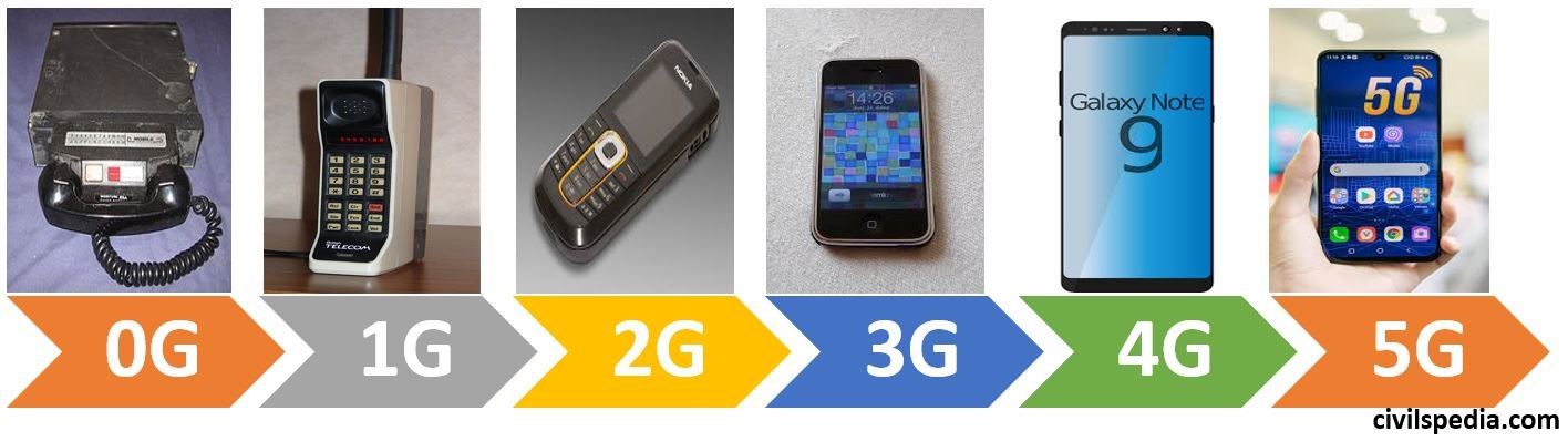
0G
- It is also known as Mobile Radio Telephone or Pre-Cellular.
- It was usually mounted in cars & trucks although briefcase models were also available.
- Motorola in conjugation with Mobile Telephone System (MTS) introduced it in the US in 1946.
1G
- 1G technology was Analog Telecommunication standard.
- It was introduced in the 1980s.
- Main Use: Voice Calls.
- Limitations: Limited capacity, not secure and background interference.
- Speed: 2 Kbps
2G
- It was commercially launched as GSM standard in Finland in 1991.
- It uses Digital Technology (Main difference between 1G & 2G is 1G was analog and 2G was digital).
- 2G has two technologies i.e. TDMA (GSM) & CDMA.
- Main Uses: Voice calls, short messages and browsing .
- Limitations: Low network range and slow data rates due to which it can’t handle complex data such as videos .
- Speed: 64 Kbps
2.5G
- 2G cellular technology with GPRS (General Packet Data Service) is called 2.5G.
- It provides the usage of e-mails, MMS, web browsing and camera facilities.
- Speed: 144 Kbps
EDGE or 2.75G
- EDGE = Enhanced Data Rule for GSM Evolution
- It has the same network design, but the data speed was increased noticeably (3 times that of GPRS) .
- It had the added advantage that there was no need to install additional hardware by the telecom companies.
3G
- 3G was introduced in 2000.
- Improvements over 2G: Clarity in Voice calls, digital broadband and increment in speed.
- Main Uses: Text and high speed internet.
- Limitations: High power consumption, Low network coverage and High cost of spectrum licence.
- Speed: 2 Mbps
- Introduction of 3G technology gave rise to applications not previously available like
- Mobile TV
- Telemedicine
- Video on Demand
- Videoconferencing
- Location based services
4G
- Benefits over 3G : Very high speeds at lower price than 3G.
- Main Uses: High speed applications, IP Telephony , Video Calling , gaming services, HD Tv, 3D TV and Wearable devices.
- Limitations: LTE supported mobiles and complicated hardware required to use 4G mobile technologies.
- Speed: 1 Gbps
LTE (Long Term Evolution)
- 4th Generation Network is called LTE (Long Term Evolution).
- LTE was designed only as data network.
- LTE has brought very high bandwidth to mobile devices and data transfer has become very fast.
VoLTE (Voice Over LTE)
- VoLTE is a voice technology that works over the LTE data connection.
- It has extremely high voice quality. It also includes the ability to make video calls.
5G
- 5G technology has ultra High Speeds and presents a big leap forward from the present 4G technology.
- Main Use :
- Internet of Things (5G System will be intelligent enough to allocate resources. Eg: Driverless car which needs to take a decision in a fraction of seconds will be given greater bandwidth than ordinary user).
- Hologram TV
- Augmented reality
- Limitations: It is not Net Neutral and involves high costs.
- It will use drones and balloons to provide internet everywhere.
- Speed: more than 20 Gbps.
Advantages of 5G Technology
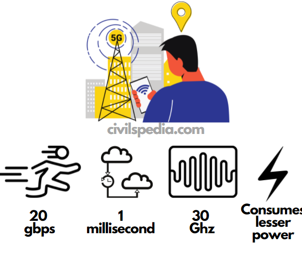
- Faster data speed of more than 20 Gbps.
- Ultra-low latency: Latency refers to the time it takes for one device to send a packet of data to another device. In 4G the latency rate is around 50 milliseconds but 5G will reduce that to about 1 millisecond. Hence, it can be used in driverless cars where such things are required.
- 5G has 30 GHz of available spectrum in comparison to lesser 3 GHz for 4G.
- 5G antennae consume very little power compared to existing technology. Hence, it will make 5G handsets energy efficient.
- With higher speed, 5G will improve the quality of remote learning by allowing real-time interactivity and transporting students to virtual classrooms.
- As per the OECD Committee on Digital Economic Policy, 5G technologies rollout will help in increasing GDP, creating employment and digitizing the economy.
- It will help to incorporate technologies such as the Internet of Things (IoT) & Artificial Intelligence in our lives. It is said that 5G is the foundation for realising the full potential of IoT.
- Agriculture: 5G can enable improvement in the entire value chain, from precision farming, smart irrigation, improved soil and crop monitoring, to livestock management.
Challenges in rolling out 5G
- 5G will not be net neutral.
- Integration of various standards of 5G: There are already multiple groups working to come up with standards around interoperability, backward compatibility with older technologies etc. Thus standardisation becomes a major challenge
- Building Infrastructure: It is a huge task, with issues around spectrum and installing new antennas.
- Expensive Spectrum in India than other countries.
- Lack of skilled professionals who can advance 5G technology.
- The reluctance of people to adopt and support the technology due to unaddressed rumours related to possible health hazards posed by 5G radiations.
- Obstacles like buildings, trees and even bad weather can cause interruptions which would require more base stations to be built to ensure better connections.
Other information
- South Korea has become the world’s first country to launch 5th-Generation (5G) networks.
- Shanghai has become the World’s First City With 5G Network Coverage.
Indian readiness to adopt 5G
- In India, Steering Committee, headed by AJ Paulraj has submitted a report titled ‘Making India 5G Ready’.
- Jan 2021: Bharti Airtel successfully demonstrated its live 5G service in Hyderabad, the first in India showcasing its readiness for the 5G technology.
- Department of Telecommunication (DoT) has given permission to 4 Telecom Service Providers (TSPs) i.e. Jio, Airtel, Vi and MTNL for conducting trials for the use of and applications of 5G technology (May 2021).
- D10 Club: “D10″ club is the group of 10 Democratic countries– UK, US, Italy, Germany, France, Japan and Canada plus Australia, South Korea and India with aim of creating alternative suppliers of 5G equipment and other technologies to avoid relying on China.
2019 Huawei Issue
Chinese company Huawei is the frontrunner in 5 G Technology. But the US is against the operations of Huawei because of the following reasons:-
- Huawei’s founder is an ex-PLA Officer & Huawei indulge in cyber espionage & leaking data to the Chinese government.
- Other Reason – The US doesn’t want that monopoly of its tech giants like IBM, Google etc is threatened. Until now, rules of the game were written by US firms but Huawei is challenging it (whoever writes the rules will have inherent benefit in future).