The Northern Mountains
This article deals with ‘The Northern Mountains (Geomorphology of India).’ This is part of our series on ‘Geography’, which is an important pillar of the GS-1 syllabus. For more articles, you can click here.
6 physiographic divisions of India
India can be divided into 6 Physiographic features.
- The Northern Mountains
- The Great Northern Plains
- The Peninsular plateau
- The Indian Desert
- The Coastal Plains
- The Islands
The Northern Mountains
- Himalayas extend ~2500 km in length, passing through 12 Indian states covering 17% of the Indian geographical area & consist of many valleys between them.
- These mountains consist of the youngest and the loftiest mountain chains in the world because they were formed only a few million years ago due to the collision of the Indo-Australian and Eurasian plates.
- The region is vast, rugged & versatile, supporting remarkable cultural, ethnic & biological diversity.
Formation of Himalayas
- The Himalayas were formed due to the convergence of tectonic plates, i.e. Indo-Australian plate in the south and the Eurasian plate in the north.
- The place where the Himalayas are situated today was occupied by the Tethys Sea. On its sea bed, sediments were deposited, brought by the then rivers from the Tibetan plateau in the north and Gondwana land (Deccan Plateau) in the south.
- About 70 million years ago, the Indo-Australian plate separated from Gondwanaland and started to move towards the Eurasian plate at a speed of 12cm/year. As a result, Tethys Sea began to contract.
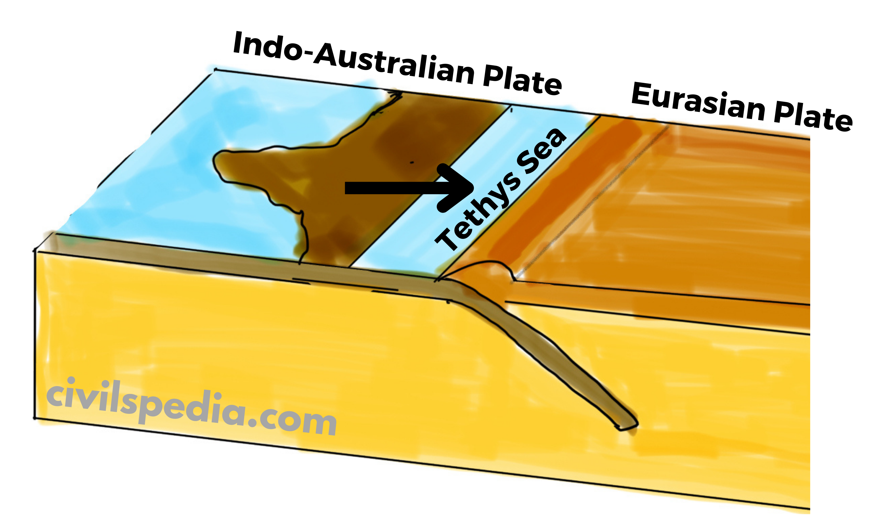
- Since the Indian plate was made up of denser material than the Eurasian plate, the Indian plate started to subduct under the Eurasian plate causing the lateral compression and folding of sediments accumulated in the Tethys Sea. The Himalayas are thought to have formed as a result of the compression of sediments from the Tethys Sea over three distinct stages.
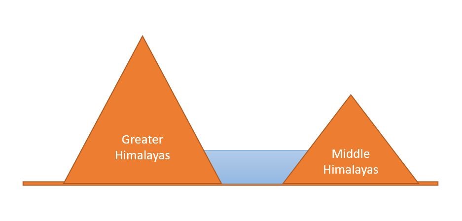
- First Phase: Started about 50 million years ago and completed 30 million years ago with the formation of the Great Himalayas.
- Second Phase: Took place between 30 to 25 million years ago, resulting in the formation of the Middle Himalayas.
- Third Phase: Took place between 20 to 2 million years ago, resulting in the formation of Shivaliks.
- The Indo-Australian plate is still moving northwards at 5 cm/year, and the Himalayas are still rising.
Divisions of Northern Mountains
- The collision of the Indo-Australian plate with the Eurasian plate was not smooth. This collision led to the formation of a number of ranges. These ranges include Trans-Himalayas, Himalayas and Purvanchal. The Himalayas and other high peaks are joined by the Pamir Knot, also referred to as the “Roof of the Earth.”
- In India, the Northern Mountains are grouped into three divisions. 1) The Trans-Himalayas, 2) the Himalayas, 3) the Eastern or Purvanchal Hills.
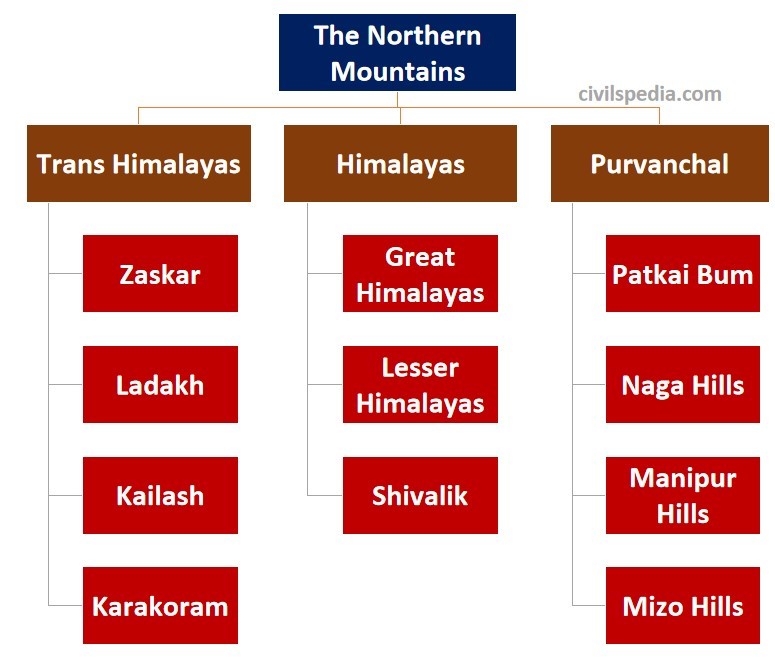
1.1 Trans Himalayas
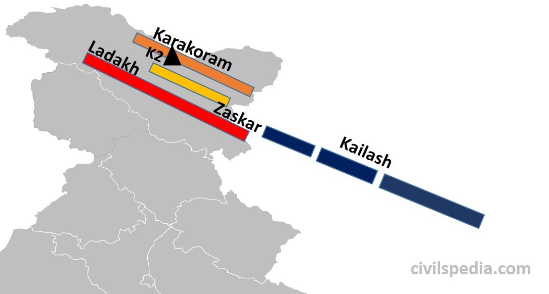
- It lies north of the great Himalayan range in Kashmir, Ladakh, and the Tibetan plateau.
- They are of volcanic origin as they were formed by the volcanic eruption due to the initial interactions between the oceanic part of the Indo-Australian and Eurasian plates.
- They also contain the Tethys sediments.
- The prominent ranges of the Trans Himalayas are Karakoram, Ladakh, Zaskar and Kailash.
- It has some of the highest peaks in the world, like K2 (the highest mountain peak in India and the second-highest peak in the world).
- To the north of trans-Himalayas lies the heavily dissected, eroded, flat region known as the Tibet plateau. This region has numerous saline lakes like Salt Lake, Pangong Tso, Tso Moriri etc.
- Karakoram-Ladakh region has India’s largest notified protected area (i.e. national park) known as Hemis National Park. It has the highest density of Snow Leopards in the world.
1.2 The Himalayas
- The Himalayas are the core part of the northern mountains.
- The Himalayas extend from the Indus Gorge in the west to Namcha Barwa (or Dihang Valley or Brahmaputra Gorge) in the east (~2500 km).
- These are young fold mountains formed very recently in Earth’s geological history.
- The shape of the Himalayas is like a convex curve towards our country, whose middle portion is sagged inwards India. Its reason lies in the process of its formation. When Indo-Australian Plate collided with Eurasian Plate, Aravalli and Shillong Plateaus were situated at the western and eastern edge of the colliding region where the Himalayas were formed. Hence, the western and eastern edge was strong, but the middle part was plain & therefore weak, which got sagged, resulting in the convex shape of the Himalayas.
- The slope of these mountain ranges in the south towards India is very steep, whereas it has a gentle slope towards China in the north (due to the presence of the high Tibetan Plateau). That is why it is difficult to cross the Himalayas from the south.
- Many Antecedent rivers reach plains after passing through the Himalayan mountains. Antecedent rivers are those that were present before the formation of the Himalayas, and their water source is beyond the Himalayas. Although their path was blocked due to the formation of the Himalayas, they gradually made their way after eroding the Himalayas. These include Indus, Sutlej, Brahmaputra etc.
- The main divisions of the Himalayas are
- Greater Himalayas
- Lesser Himalayas
- Shivaliks
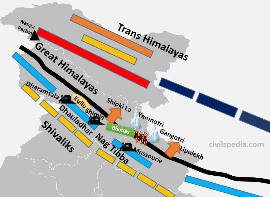
1.2.1 The Greater Himalayas
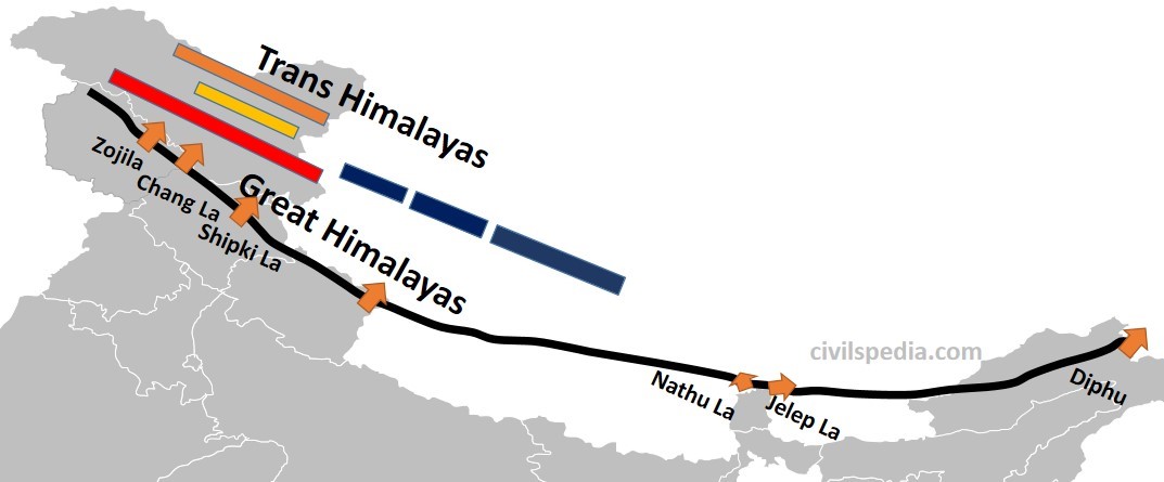
- These are also known as Internal Himalaya or Himadri.
- They are about 25 km wide.
- The average height in this range is 6100 meters. Mount Everest (8,848 m), the highest peak in the world, is also situated in this range along with other high peaks like Kanchenjunga, Makalu, Dhaulagiri etc.
- Due to their great heights, the peaks of almost all mountains remain snow-covered throughout the year. Since it is a region with permanent snow cover, it has many glaciers like Gangotri, Yamnotri, and Siachin.
- It is the longest and most continuous sub-division of the Himalayas. Its length is 2400 km and extends from Nanga Parbat (or Indus Gorge) in north–west to Namcha Barwa (or Dihang Valley or Brahmaputra Gorge) in the east.
- It contains sedimentary rocks (due to the folding of sediments of the Tethys Sea) as well as Metamorphic rocks (due to pressure created by the collision of two plates).
- It contains many passes. Although, it is very difficult and dangerous to cross this mountainous subdivision. But still, many passes are found to cross this, like Burzil and Zojila in Kashmir, Chang La in Ladakh, Shipki La in Himachal Pradesh, Lipulekh in Uttarakhand, Nathula and Jelep La in Sikkim and Diphu pass in Arunachal Pradesh.
- The Greater Himalayas receive less rainfall than the Lesser Himalayas and the Shivaliks.
1.2.2 The Lesser Himalayas
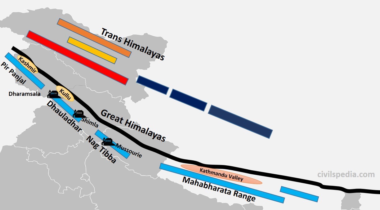
- They are also known as Himachal or Middle Himalayas.
- The height of this range varies from 3,700 to 4,500 m.
- Its width varies up to 80 km. (hence, it is lower in height but wider than Greater Himalayas)
- Slate, limestone & quartzite are the major rocks found in this range.
- This region is subjected to extensive erosion due to heavy rainfall, deforestation and urbanization.
- It also contains famous hill stations of the Himalayas like Shimla, Mussourie, Nainital, Almora, Ranikhet and Darjeeling.
- Lesser Himalayas are not a continuous range (unlike Greater Himalayas) and is divided into
- Pirpanjal (J&K)
- Dhauladhar (Himachal Pradesh)
- Nag Tibba (Uttarakhand)- Mussourie & Kumaon ranges are part of Nag Tibba
- Mahabharata Range (Nepal)
- The region between Greater Himalayas and Lesser Himalayas contains many valleys like Kashmir Valley, Kangra Valley, Kullu Valley, Bhagirathi Valley and Mandakini Valley.
- Many passes are also present, which provide passage through Lesser Himalayas to reach these valleys like Banihal and Qazigund, connecting Jammu with Kashmir.
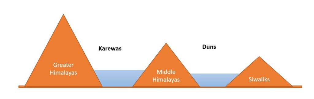
1.2.3 The Shivaliks
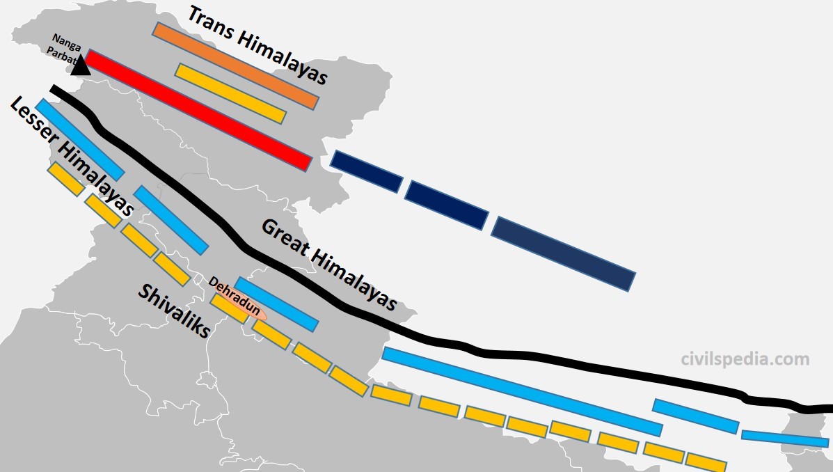
- Also known as Outer Himalayas and Southern Himalayas
- Siwaliks extend from Jammu and Kashmir to Assam.
- Their average height varies between 900 to 1200 metres. Hence, they are the lowest among all Himalayas.
- It is mainly made by the debris brought by the Himalayan rivers as they were geologically formed during the Tertiary period by the upliftment of the foothills of the Himalayas, where rivers have settled their sediments.
- It is the most discontinuous range.
- Longitudinal valleys are found between the Shivaliks and the Lesser Himalayas, which are called Duns. The most famous among these are Dehradun, Patlidun, Udhampur etc.
- They are known by various names like
- Jammu Hills (in J&K)
- Dhang and Dundwa (in Uttaranchal)
- Churia Ghat Hills (in Nepal)
- Dafla, Miri, Abhor and Mishmi (in Arunachal)
1.3 Purvanchal
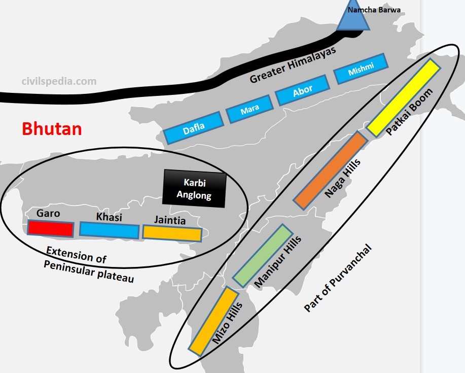
After crossing Dihang Gorge, the Himalayas bends southward (syntaxial bend), forming a series of hills. They have the same progeny as that of the Himalayas & are part of the Northern mountain system. They are aligned north to south and are known by different local names.
| Patkai Bum | Forms border between India and Myanmar |
| Naga Hills | Situated in Nagaland and forms the border between India and Myanmar |
| Manipur Hills | The physiography of Manipur is unique, represented by the presence of ‘Loktak’ lake in the centre and surrounded by mountains called Manipur Hills from all sides. |
| Mizo Hills | – They are also known as the Lusai Hills. – Mizoram is also known as the ‘Molasses Basin’ as it is made up of soft unconsolidated deposits brought by small rivers originating in these hills. |
| Arakan Yoma | Purvanchal extends in Myanmar as Arakan Yoma, which further continues southwards as Andaman and Nicobar Islands. |
Above ranges in the Purvanchal are separated from each other by numerous small rivers.
Note: Garo, Khasi, and Jaintia hills of the Meghalaya plateau are not a part of Purvanchal or the Himalayas in general. They are an extension of the Peninsular Plateau.
2. Longitudinal Divisions of Himalayas
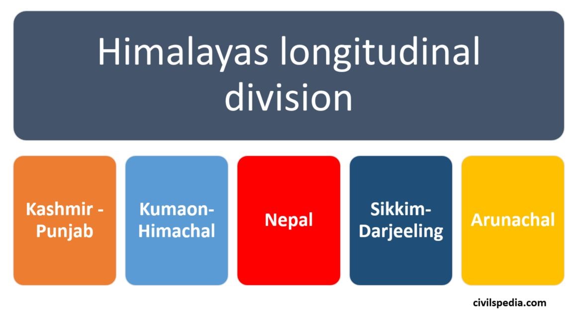
There is another way to divide the Himalayas longitudinally into Kashmir-Punjab Himalayas, Kumaon Himalayas, Nepal Himalayas, Sikkim-Darjeeling Himalayas and Assam Himalayas.
2.1 Kashmir-Punjab Himalayas
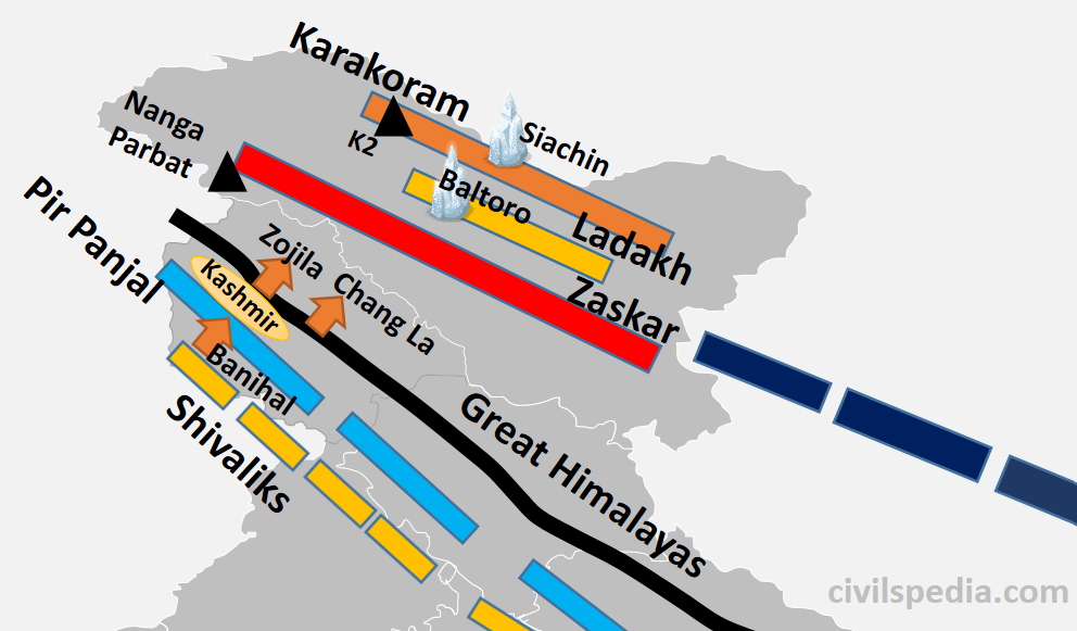
- Major Characteristic of the Kashmir Himalayas is deep valleys, and high mountain passes like Zoji la, Bara Lacha La, Banihal and Qazigund.
- Between Great Himalayas and the Pir Panjal range lies the world-famous valley of Kashmir
- The Baltoro and Siachen glaciers, two significant glaciers in South Asia, can also be found here.
- Kashmir Himalayas are famous for its Karewa formations, known for cultivating Zafran, a local variety of saffron.
- Some of the important freshwater lakes like Dal & Wular and saltwater lakes like Pangong Tso & Tso Moriri are also in this region. ( Note: Dal Lake is Oxbow Lake).
- Srinagar is located on the banks of the Jhelum River, and Dal Lake, situated in Srinagar, presents an interesting geographical feature. Jhelum River in Kashmir valley is still in its youth stage but forms a meander – a feature associated with the mature stage of rivers.
Side Topic: Karewas Formation
- During the Quaternary period, when Pir Panjal Mountains were formed, the Kashmir valley, surrounded by Great Himalayan Range in the north & Pir Panjal Range in the south, was submerged under water, and a big lake of about 5000 sq km area was formed. All the sediments that rivers brought to this giant lake kept settling downwards.
- Later, because of endogenic forces, Baramullah Gorge was created, and this vast lake was drained through the gorge leaving behind sediments. These deposits are called Karewas. Hence, Karewas are fluvio-lacustrine Plains
- Examples of lacustrine plains include.
- The Kashmir Valley of India.
- The Imphal Basin in the Manipur hills
- The watershed of the Red River in the USA and Canada
- The Karewas are well suited for the cultivation of saffron, walnut, almond, and orchards.
Jhelum is still in its Youthful stage in Kashmir, but it forms Meanders, characteristic of the Mature Stage. Why?
- Meanders are formed when moving water erodes the outer banks, whereas the inner part of the river, having less intensity, deposits silt and sediments, which results in a snake-like pattern of the water stream.
- The main requirement for the Meander formation is the need for silt and sediments and the slow speed of river waters.
- In Kashmir valley, these sediments are provided by local base levels of formerly existing Karewas.
- It is the reason Jhelum meanders. Along with that, the formation of Wular Lake, which is an Oxbow lake, is also explained by this phenomenon.
2.2 Kumaon-Himachal Himalayas
- Mountains in Kumaun Himalayas are
- Great Himalayas
- Middle Himalayas – Dhauladhar & Nag Tibha (Garhwal & Kumaon Ranges ).
- Shivalik (locally called Dhang and Dundwa Range in Uttaranchal)
- In Lesser/Middle Himalayas section of the Kumaon-Himachal Himalayas, the altitude between 1,000-2,000 m attracted the British colonial administration due to its moderate climate (resembling the British weather). Subsequently, important hill stations such as Dharamshala, Mussorie, Shimla, Kaosani etc., were developed in this region.
- Dun formation is an important feature of this part. The largest of all the duns, Dehra Dun measures roughly 35–45 km in length and 22–25 km in width.
- This section, too, has passes like Shipki La and Lipulekh pass. Lipulekh is used as a pathway to reach Kailash Mansarovar in Tibet.
- In the Great Himalayan section of the Kumaon-Himachal Himalayas, the valleys are inhabited mainly by the Bhotias. The Bhotias is a nomadic tribe that moves to the higher ranges’ called “Bugyals” (summer grasslands) in the summer and return to the valleys in the winter.
- Kumaon-Himachal Himalayas has many glaciers like Nandadevi, Badrinath, Kedarnath, Gangotri and Yamnotri, a source of rivers like Yamuna and Ganga. Many pilgrimages, such as the Gangotri, Yamnotri, Badrinath, Kedarnath and Hemkund Sahib, are also situated here.
Side Topic: Duns formation
- Duns are the same as Karewas, i.e. they too are fluvio-lacustrine plains formed with sediments left behind by a former lake, with the only difference being that they are formed between Middle Himalayas and Siwaliks.
- When Shivalik was formed, drainage of the region was impounded & the whole area was submerged in water between Shivalik & Middle Himalayas, creating a huge lake. The river gradually finds weak rocks to cut across mountains & flows through it. Lake dries up & duns are formed by the sediments left by the former lake.
- E.g. Dehradun between Siwaliks and Mussoorie range, Jammu Dun between Pir Panjal and Shivaliks, Pathankot Dun between Siwaliks and Dhauladhar, Chandigarh-Kalka dun etc.
- Some of the water remained in the depressions forming lakes known as Taals. Examples include Nainital, Bhimtal etc.
2.3 Nepal Himalayas
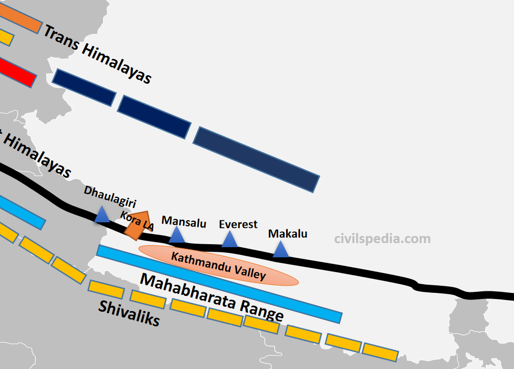
- It is the tallest section of the Himalayas.
- Mountain sections in it include
- Great Himalayas containing peaks like Dhaulagiri, Annapurna, Mansalu, Everest, Makalu etc
- Middle Himalayas: Mahabharata range
- Shivaliks (locally called Churia Ghat Hills)
- The famous and densely populated Kathmandu Valley is situated between Great Himalayas and Middle Himalayas.
- Passes like Kora La connects Kathmandu valley with Tibet (will be used by China to build railways and roads and was in the news).
2.4 Sikkim/Darjeeling Himalayas
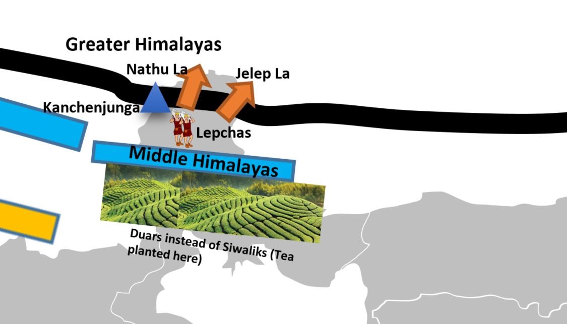
- Sikkim Himalayas lies between Kosi & Teesta Rivers.
- It is an area with deep valleys and lofty mountain peaks like Kanchenjunga (Kanchengiri).
- Lepcha tribes inhabit the higher reaches of this region, while the southern part (Darjeeling) has a mixed population consisting of Bengalis, Nepalis and tribals from Central India.
- The British established tea plantations in this area by taking advantage of the favourable physical circumstances, which included a moderate slope, thick soil cover with high organic content, evenly distributed rainfall throughout the year, and mild winters. They, together with the Arunachal Himalayas, stand out from the other Himalayan ranges due to the absence of the Shivalik formations. Here, the “duar formations” are significant—which have also been exploited to create tea gardens.
- Sikkim & Darjeeling Himalayas are known for their scenic beauty & rich flora & fauna, particularly various orchids.
- Sikkim Himalayas has passes like Jelep la ( forming a tri-junction of India-China-Bhutan) and Nathula.
Side Topic: Duars
- Duars are floodplains on the foothills of the Himalayas in Assam and the northern part of West Bengal (Darjeeling).
- They are made up of loose sediments brought down by Himalayan rivers and deposited each season. The streams often than not shift course and spread the load over broad tracts. Some streams disappear underground and re-emerge only later. It makes duars very damp regions.
- Duars are not the peneplains (uniform and almost levelled plain). They may have considerable height. The altitude of this region varies widely, with as low as 90 m and as high as 1,750 m.
- The British introduced tea plantations in this region due to the following physical conditions.
- Moderate slope.
- well-distributed rainfall throughout the year
- Thick soil with high organic content
- Mild winters (tea can’t withstand frost & snow)
2.5 Arunachal Himalayas
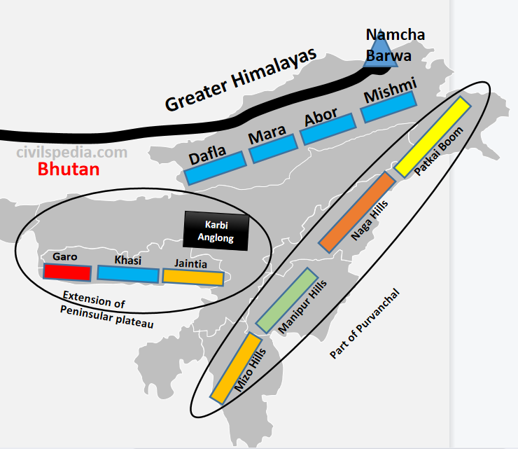
- Arunachal Himalayas spans between Bhutan Himalayas (in the east) to the Namcha Barwa (in the west).
- They have the following sections
- Greater Himalayas
- Middle Himalayas are absent
- Shivaliks are known by the names Dafla, Miri, Abor and Mishmi.
- Important mountain peaks of the Arunachal Himalayas include Kangtu & Namcha Barwa.
- Rapidly moving rivers cut deep gorges in these mountain ranges. The Brahmaputra cuts a deep gorge after crossing Namcha Barwa called Dihang or Brahmaputra gorge. The Kameng, Subansiri, Dihang, Dibang, and Lohit are the other significant rivers of this region. They have huge hydroelectric power potential since they are perennial and have a high rate of fall.
- Arunachal Himalayas are inhabited by numerous ethnic tribal communities. Some of the prominent ones are the Abor, Mishmi, Nyishi and Nagas. Primarily, they practise Jhumming agriculture.
Side Note: Important Passes in the Himalayas
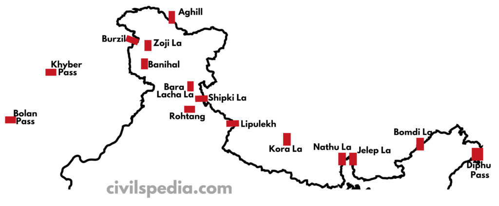
As previously discussed, the Himalayas and associated mountains have many passes. These types of questions can be asked in the exam. Hence we are going to provide a list in concentrated form
| Aghill pass | Ladakh | Connects Ladakh with Xinjiang province. |
| Burzil Pas | Ladakh | Connecting link between India and Afghanistan and other Central Asian countries. |
| Zoji La | J&K and Ladakh | Connects Kashmir valley with Ladakh. |
| Bara Lacha La | Himachal | Connects Manali in Himachal Pradesh to Ladakh. |
| Shipki La | Himachal | River Satluj enters India through it and it is the sole trade route between India and Tibet |
| Lipulekh | Uttarakhand | – It is at the trijunction of India (Uttaranchal), Nepal and China. – Kailash Mansarovar Yatra use this pass – It was in the news due to the Kalapani dispute with Nepal because Lipulekh sits at the top of Kalapani. |
| Jelep La | Sikkim | Tri Junction of India, Bhutan and China |
| Nathu La | Sikkim | Important trade route between India and China |
| Bomdi La | Arunachal | Connects Arunachal with Lhasa. |
| Diphu Pass | Arunachal | Tri Junction of India, Myanmar and China |
| Khyber Pass | Pakistan | Connects Pakistan and Afghanistan (but important because in history, invaders used this to invade India, and traders used this for trade with Central Asia) |
| Bolan Pass | Pakistan | In Pakistan (has the same history as that of Khyber Pass) |
| Kora La | Nepal | Connects Nepal and Tibet |
| Banihal & Qazigund | J&K | Connects Jammu to Kashmir & contains Jawahar Tunnel |
| Rohtang Pass | Himachal |
Side Topic: Important Glaciers
| Siachin Glacier | UT of Ladakh | In the Karakoram Ranges. It is the longest glacier outside the polar regions. |
| Baltoro | UT of Ladakh | Situated in the Ladakh ranges |
| Gangotri Glacier | Uttarakhand | Source of Ganga river |
| Yamnotri Glacier | Uttarakhand | Source of Yamuna river |
| Pindar Glacier | Uttarakhand | Source of Pindar river |
| Zemu Glacier | Sikkim | Source of Teesta river |
Importance of Himalayas
Climatic Importance
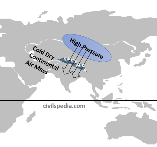
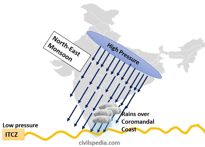
- The Himalayas protect us from the extremely cold winds coming from the north.
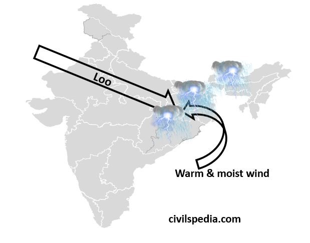
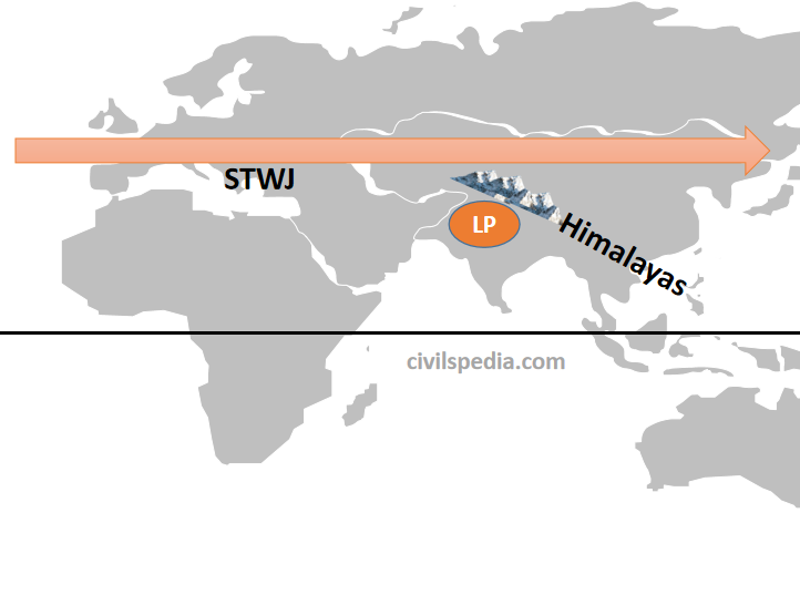
- The Himalayas also forces southwest monsoon winds to shed whole moisture in India.
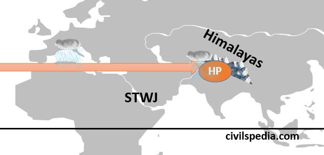
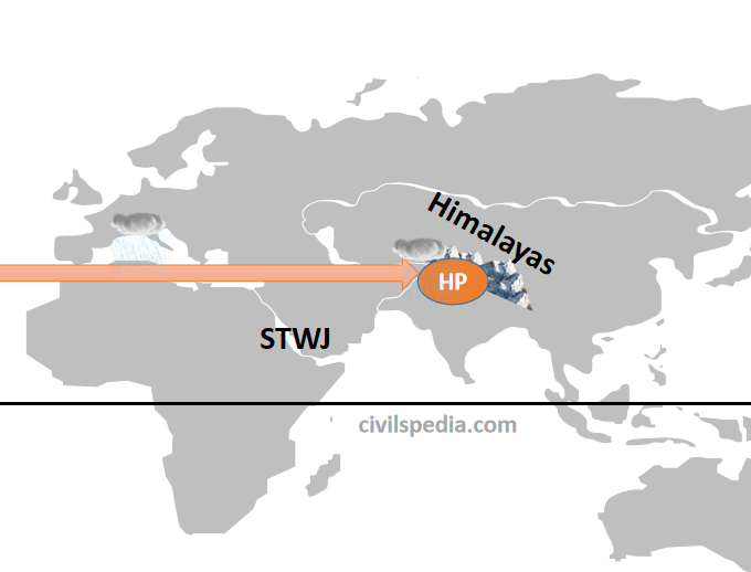
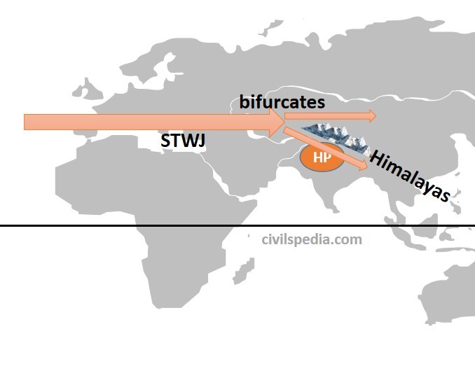
- Due to the obstruction of the Himalayas, the Westerly Jetstream shed rainfall and snowfall in winters, known as Western Disturbances.
Rivers
- The Himalayas are the source of perennial rivers which has deposited large amount of alluvium, forming the Great Plains of India.
- Various major rivers of India originate from the Himalayas. These rivers are a source of irrigation for a significant portion of agriculture in India.
- They are the source of Hydroelectric power.
Biodiversity
- Himalayas go through different bio-geographic and climatic zones. There is a succession of vegetation from topical to tundra. Hence, biodiversity is very high in the Himalayas with large endemism.
- Many animals, including tigers, snow leopards, elephants, rhinoceros, etc., are found in the Himalayas.
- A large number of herbs of medicinal value are also found in the Himalayas.
Tourism and Religious Importance
- Tourists from all over the world visit the hill stations situated in the Himalayas. E.g. McLeod Ganj, Shimla, Nainital Mandi, Mussoorie, Darjeeling etc.
- Various religious places are also part of the Himalayas, e.g. Kailash, Amarnath, Kedarnath, Vaishno Devi, Jawala Ji, Chintpurni, Gangotri, Yamnotri, Hemkund Sahib etc.
Mineral Resources
- The Himalayas are rich in metallic minerals such as copper, lead, zinc and gold.
- The Himalayan rock salt is used in traditional medicines and aromatherapy.
- The Siwaliks are a very good source of limestone.
- Coal is found in Jammu & Kashmir (Kalakot) and Arunachal Pradesh (Namchik-Namphuk)
- Petroleum in India was first discovered in the Himalayas in the upper Assam region.
Defence against Hostile Powers
- The Himalayas act as a natural border with China.