Last Updated: July 2025 (Impacts of Climate Change)
Impacts of Climate Change
This article deals with ‘Impacts of Climate Change – UPSC.’ This is part of our series on ‘Environment’, an important pillar of the GS-3 syllabus. For more articles on Science and technology, you can click here.
Introduction
The Climate Change we will talk about in this article pertains to the change in the climate because of human-induced factors.
Even before humans, the Earth’s climate has changed throughout history. In the last 6.5 lakh years, Earth has passed through 7 ice ages. The last ice age ended approx. 7000 years ago, also marking the beginning of human civilization.
But the climate change that we are witnessing now is entirely different. The earlier changes were primarily attributed to minor variations in the Earth’s orbit, which changed the amount of solar insolation received by Earth’s atmosphere or volcanic eruptions.
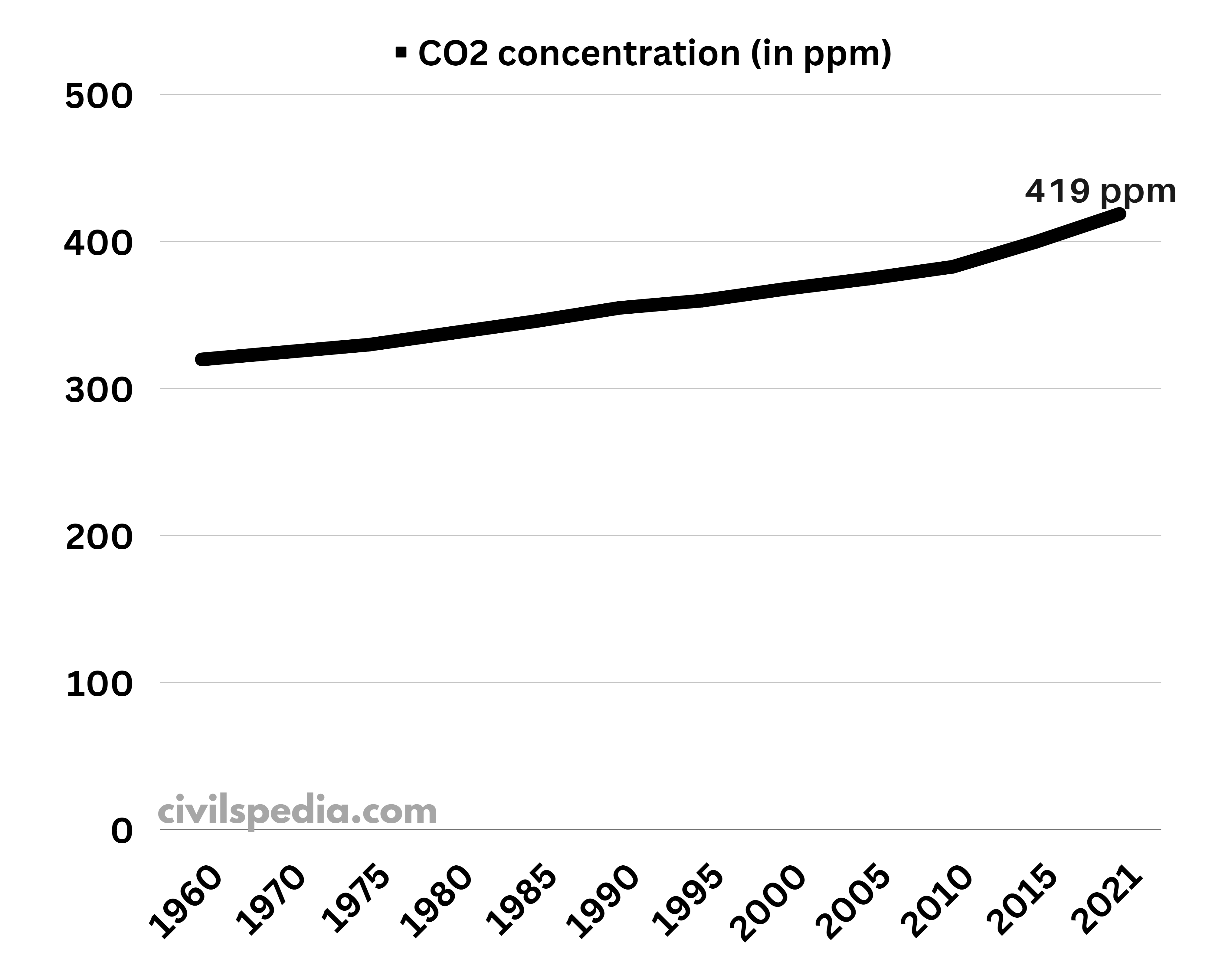
The reason for the present climate change is the increase in the concentration of heat-trapping gases (or Green House Gases) in the Earth’s atmosphere due to the increase in the rate of burning of fossil fuels.
Mauna Loa Atmospheric Baseline Observatory (Hawaii) has been recording the CO2 concentration since 1958. The concentration reached dangerous levels of 415 ppm in 2019 and 420 ppm in 2023.
Many people, especially from countries like the USA, UK etc., known as Climate Sceptics, don’t accept that Global Warming and Climate Change are real. After fighting for years against denialism, scientists have now been successful in making world leaders realize that we need to act against climate change if we want to avoid the potentially huge cost to the economy and society worldwide caused by the “irreversible build-up of greenhouse gases (GHGs) and warming of the globe.”
Evidences and Impacts of Climate Change
1. Glacier Retreats
- Glaciers have been melting rapidly due to global warming, leading to a phenomenon known as Glacier Retreat. The examples include Hindukush – Karakoram – Himalayan Glacier Retreat and Kaskawulsh Glacier Retreat (Kaskawulsh is Canada’s one of the largest glacier).
- The breakdown of Larsen C Glacier (in the Antarctic) is the result of Climate Change and Global Warming.
Impact of Glacier Retreat
- Shortage of Water: The glacier retreat can result in a water shortage in the river streams fed by the glaciers. Therefore, it will negatively impact the lives of people living in those river basins.
- River Piracy: Climate Change has resulted in the retreat of one of Canada’s largest glaciers (Kaskawulsh Glacier). It led to an incident called ‘River Piracy’ by the researchers.
- Earlier (Before Retreat): The glacier was feeding Slims River (taking water to the Bering Sea)
- Now (After Retreat): The glacier feeds Alsek River (taking water to the Gulf of Alaska)
- Habitat Loss: Animals that dwell on or near glaciers may be pushed towards extinction—for example, tiny ice worms.
- Contaminants: Persistent Organic Pollutants (POPs) such as PCBs (Polychlorinated Biphenyls) are transported in the air from their source to cooler areas where they condense and are deposited in glacial ice. Rapid melting has begun to release them back into the environment. For example, in some Canadian lakes, glacial meltwater is the source of 50-97% of the various POPs entering the lake.
- Flooding: Rapid melting of glaciers can lead to flooding in rivers.
- Sea Level Rise: Sea-level rise will affect coastal regions worldwide, causing erosion and saltwater intrusion into aquifers and freshwater habitats.
2. Climate Change and Oceans
Climate Change and global warming have impacted the oceans negatively in various ways.
1. Ocean Acidification
- As CO2 concentration in the atmosphere has increased, more CO2 is being dissolved in Ocean Waters, leading to the formation of Carbonic Acid. It increases the pH of Ocean Water (i.e. makes it acidic), which harms the calcifying animals.
2. Ocean Warming
- According to the IPCC Report, the world’s oceans have absorbed 90% of the temperature rise caused by man-made GHG emissions.
- Ocean warming creates anoxic (i.e., waters with no dissolved oxygen) and hypoxic (i.e. waters with low oxygen concentration) zones. It leads to the destruction of the ecosystem in those zones.
3. Sea Level Rise
- Sea Level rise happens due to two reasons
- Glaciers melting at a faster pace
- The density of warm water is lower (leading to higher volume)
- Impact of Sea Level Rise is as follows
- Large-Scale Displacement: 10% of the world’s population lives on the coast, which faces the danger of getting displaced. Additionally, many islands will disappear (like Kiribati, Maldives, Tuvalu, etc.)
- The saltwater intrusion into surface waters will exacerbate the issue of drinking water shortage.
- Increasingly severe storm surges will cause damage to property situated on coasts.
- International Conflicts: Sea Level Rise will change nations’ exclusive economic zones, potentially creating conflicts between neighbouring nations.
4. Changes in Ocean Current Patterns
- Oceans are now receiving more fresh water due to climate change. It is changing the patterns of Ocean Currents, thus resulting in strange weather phenomena. E.g., increase in the frequency of tropical cyclones and El-Nino.
- It is disrupting the marine food chains.
5. Negative Impact on Food Security
- Rainfall Patterns Affected: Precipitation patterns in a number of areas have changed, resulting from large-scale atmospheric teleconnections with ocean warming.
- Due to Ocean Warming, more rain happens over the ocean and rainfall on land decreases. It impacts agriculture negatively.
- Due to Ocean Warming, the size of fish is decreasing. The experiment showed that fish raised in warm waters weighed less and had lower metabolic performance than those raised in lower temperatures.
6. Deoxygenation (Creation of Dead Zones)
- Ocean warming leads to deoxygenation, i.e., reduced dissolved oxygen in ocean water. It negatively impacts the marine species, ecosystems and fundamental benefits humans derive from the ocean.
7. Migration of Animals
- Ocean Warming is leading to the migration of tropical marine creatures towards temperate areas, thus disturbing the food chain, food availability and biodiversity of a region.
3. Climate Change and Island Submergence
- Island states such as Tuvalu, Mauritius etc., are on the verge of submergence.
- Kiribati is on the verge of drowning and will become the first country to drown due to sea level rise due to climate change
- A World Bank report stated that some of these states, including the Marshall Islands and Tuvalu, may lose their status as a nation if sea levels continue to rise at this rate.
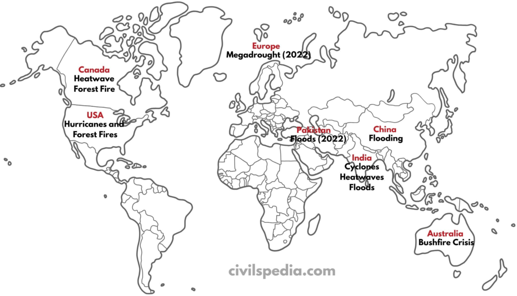
4. Increase in frequency of Extreme Events
- As per the Sixth Assessment Report (AR6) of the Intergovernmental Panel on Climate Change (IPCC), human-induced climate change has likely increased the frequency and intensity of extreme events since pre-industrial times, including heatwaves, extreme precipitation events, marine heatwaves, etc.
- For example, since 2020, we have seen a large number of extreme events like
- Heatwave in Canada and parts of the USA. Temperatures in Canada have reached as high as 49.4 °C.
- Floods in Germany, New South Wales (Australia), Pakistan (2022) and India (2023).
- Forest Fires in Canada and Europe (2022, 2023 and 2024) and Bushfires in Australia (2020).
5. Impact on Flora and Fauna
- Rapid climate change is more than the ability of animals to adjust. In 1999, the death of the last Golden Toad in Central America marked the first documented species extinction driven by climate change. Experts opine that one-fourth of Earth’s species will face extinction by 2050 due to climate change.
- Animal and plant species are responding to earlier springs—E.g, earlier frog breeding, bird nesting, flowering, and migration of birds and butterflies.
- Increased Frequency of Wildfires: As the Earth gets warmer and droughts increase, wildfires are expected to occur more often and be more destructive. Wildfires do occur naturally, but the extremely dry conditions resulting from droughts allow fires to start more easily, spread faster, and burn longer.
- The distribution of tree lines, plants, birds, mammals, insects, fish, reptiles, and marine invertebrates is shifting towards the poles.
- The distribution of plants is shifting to higher elevations.
- Tropical reef corals are expanding poleward.
6. Impact on Health
- Global Warming has led to greater frequency & severity of heat waves. In 2003, for example, extreme heat waves caused more than 20,000 deaths in Europe and more than 1,500 deaths in India.
- Malaria is now being reported from countries like Bhutan for the first time.
- Climate Change has increased the spread of infectious diseases, mainly because warmer temperatures allow disease-carrying insects, animals and microbes to survive in areas where they were once blocked by cold weather.
- According to the Lancet Report, Climate Change will lead to undernutrition and obesity.
- Undernutrition: Global Warming will lead to lower yields, thus resulting in undernutrition.
- Obesity: Climate Change will reduce the production of fruits & vegetables, making them expensive and forcing people to move towards processed food (high in fats, sugars, and sodium).
7. Impact on Security
Climate Change is leading to environmental degradation, food shortages, and unfair distribution of resources, likely leading to tension and conflict. The civil war in Syria has had successive droughts as one of the most important issues.
Climate Change is a security issue because
- Local Resource Competition: Due to Climate Change, pressure on local resources like water is increasing, leading to instability and violent conflict. Transboundary river water issues will become violent due to water shortage.
- Forced Migrations: World Bank Report points toward the fact that by 2050, 140 million people from South Asia & Latin America will be forced to migrate due to climate change.
- Volatile food prices heighten the risk of protest, rioting and civil conflict.
- Sea level rise and coastal degradation will lead to social disruption and disagreement over maritime boundaries (change in EEZ) and ocean resources.
Keeping this in mind, United Nations Security Council deliberated on the impacts of climate-related disasters on international peace and security.
8. Impact on Women
Women are impacted by climate change disproportionately.
- Patriarchal norms: Socio-cultural factors like regulations on movement, childcare and elderly care responsibilities, gendered cultural codes of dress etc., limit their mobility and heighten vulnerability and exposure to climate change-related extreme weather events.
- Dependence on natural resources: Women increasingly rely on natural resources for their livelihood, which is threatened by climate change. E.g., 75.7% of women in rural India are engaged in agriculture (PLFS, 2019-20).
- Public measures lack a gender equality perspective: Most policy documents lack explicit provisions for addressing the specific vulnerabilities of women across sectors.
- Inadequate access to and control over finance and productive resources: It affects women’s contribution to climate efforts and ability to recover from climate-related disasters or loss of livelihood economically.
- Lack of gendered data: The scale and scope of women’s burden related to climate change are not well understood due to inadequate data.
9. Impact on Health
- Global Warming will lead to greater frequency & severity of heat waves and extreme weather events. In 2003, for example, extreme heat waves caused more than 20,000 deaths in Europe and more than 1,500 deaths in India.
- Malaria is now being reported from countries like Bhutan for the first time.
- In 2023, Crimean-Congo Haemorrhagic Fever (CCHF) endemic to Africa started to spread in Europe.
- Climate Change increases the spread of infectious diseases, mainly because warmer temperatures allow disease-carrying insects, animals and microbes to survive in areas once blocked by cold weather.
- Climate Change will lead to undernutrition and obesity (Lancet Report) as
- Global Warming will lead to lower yields.
- Global Warming might reduce protein and other micronutrients in plants.
- Climate Change will reduce the production of fruits & vegetables, making them expensive and forcing people to move towards processed food, which is high in fats, sugars, and sodium.
10. Other Impacts
- Increased Insurance Cost: Extreme weather events influenced by climate change are causing ever greater destruction, forcing insurers to increase their premiums. The major insurance company has stopped selling insurance policies in California, citing the growing risk of catastrophes, steep construction costs and a challenging reinsurance market.
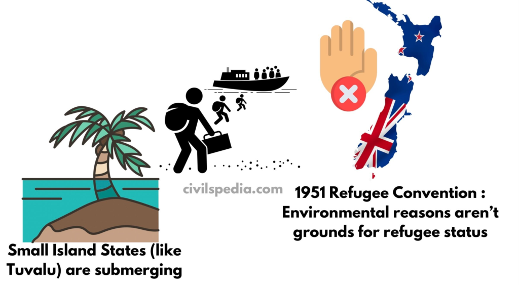
Side Topic: Climate Refugees
- Definition: People forced to migrate due to climate-induced disasters like rising sea levels, droughts, or floods.
- The issue has become more important because Nations like Kiribati, Tuvalu, Maldives face existential threats due to rising sea levels and their citizens may lose homes without refugee rights or legal resettlement options.
- Legal Gap:
- The 1951 Refugee Convention does not recognize environmental reasons as grounds for refugee status. For Example: In 2015, New Zealand rejected asylum to Ioane Teitiota from Kiribati, citing the absence of “persecution” required under the Refugee Convention.
Side Topic: Anthropocene Epoch
For the last 12,000 years, we’ve lived in the Holocene Epoch — a stable period where all human civilizations flourished. But something changed after 1950s — humans began to reshape the Earth like never before.
How Humans Changed the Planet:
- We triggered mass extinction — 75% of species may vanish in coming centuries.
- Our fertilizers doubled nitrogen & phosphorus levels in soils.
- We left permanent pollution traces in sediments and glaciers.
Scientists Take Notice
- In 2000, Nobel Laureate Paul Crutzen coined the term Anthropocene — meaning “age of humans.”
- In 2016, experts at the World Geological Congress suggested officially declaring it a new epoch.
- By 2019, a global panel voted in favour (29-4) of calling it the Anthropocene Epoch.